Long Range Thread 12.0
+30
StatenWx
Dunnzoo
weatherwatchermom
Quietace
dkodgis
mwilli5783
jrollins628
devsman
skinsfan1177
billg315
jmanley32
Snow88
chief7
Dtone
Isotherm
sroc4
docstox12
CPcantmeasuresnow
frank 638
track17
NjWeatherGuy
HectorO
SNOW MAN
rb924119
Math23x7
algae888
snow247
amugs
nutleyblizzard
Frank_Wx
34 posters
Page 32 of 40
Page 32 of 40 •  1 ... 17 ... 31, 32, 33 ... 36 ... 40
 Re: Long Range Thread 12.0
Isotherm wrote:Agreed, Frank. Not much to add at this point. We'll see how the next week progresses. I'm not optimistic about this pattern. There's always a chance that a transient block develops, and we sneak in an event within an overall poor pattern.
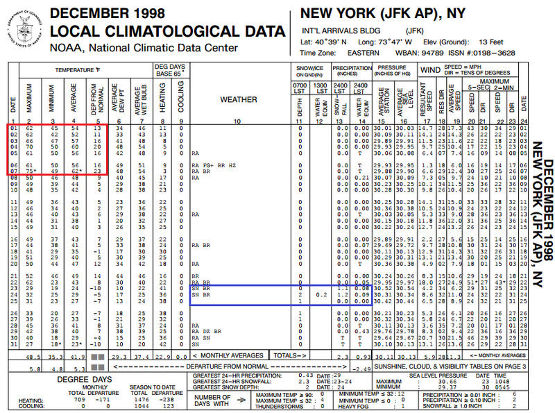
I was looking through Ray's archive. 1998-99, a terrible snow year, managed to pull off a white Christmas it appears for my area with 2-4":
http://www.raymondcmartinjr.com/weather/1999/24-Dec-98.html
Talk about lucky timing. My hopes were not high going into this winter, but if we managed a white Christmas, that would provide some satisfaction. Last one was 2009 (near miss 2010).
I remember that well. In fact, that was actually the first winter after which I became interested in weather. I remember on this day that December (the 4th), I was home sick. That afternoon, my mother said to me (I was 8 years old at the time) that it was 70 degrees. It was stunning for me to hear that it could get that warm in December in New York. In fact, much of that month was warm, at the time the second warmest December on record (It has since dropped to 6th warmest). Then I woke up the morning of December 24th to see the beautiful snow on the ground. It felt like a Christmas miracle that we had a white Christmas after all! The next day,, Christmas morning, had sunshine over a winter wonderland! Of course, the snow would melt away days later. But we did had two other snow events that winter which I remember playing in the snow: 1/8/99 and 3/15/99, the latter featuring the heaviest snow of the winter. So while it may not have been a big winter climatologically speaking, those three events were enough to fulfill me as a kid.
A lot of comparisons were made to this winter, mainly because we're coming off a Strong El Nino, but since we may not get the La Nina, I'm not sure if this can be a 1998-99 redux.
By the way, here was December 1998 for JFK airport (the NWS station closest to me) which illustrates the wild December we had:
Math23x7- Wx Statistician Guru

- Posts : 2382
Join date : 2013-01-08
 Re: Long Range Thread 12.0
Seems like the 12th now looks like a huge cuter along with every other storm the next 16 days. I hope tgats not the case. Are you no longer thinking good storm around 12th frank?
jmanley32- Senior Enthusiast

- Posts : 20646
Join date : 2013-12-12
 Re: Long Range Thread 12.0
Their seems to be a lot of uncertainty Jman going forward

skinsfan1177- Senior Enthusiast

- Posts : 4485
Reputation : 35
Join date : 2013-01-07
Age : 47
Location : Point Pleasant Boro
 Re: Long Range Thread 12.0
jmanley32 wrote:Seems like the 12th now looks like a huge cuter along with every other storm the next 16 days. I hope tgats not the case. Are you no longer thinking good storm around 12th frank?
The Pacific energy has trended too strong on the models. This causes H5 to close off and allows heights to rise along the east coast. This is why models trended to a cutter. If the energy sampled out of the Pacific is weaker, it will not cut and keep the cold air in place. Still too early to write it off.

That said - look how much this energy digs in the SW CONUS. Heights are already rising along the EC by the 11th. There is a piece of the PV in western Canada that is not helping matters either. My gut tells me this morning we will not see a storm on the 12th. Pattern does not look as favorable as it once did. I'll give it 2 more days.

_________________
_______________________________________________________________________________________________________
CLICK HERE to view NJ Strong Snowstorm Classifications
 Re: Long Range Thread 12.0
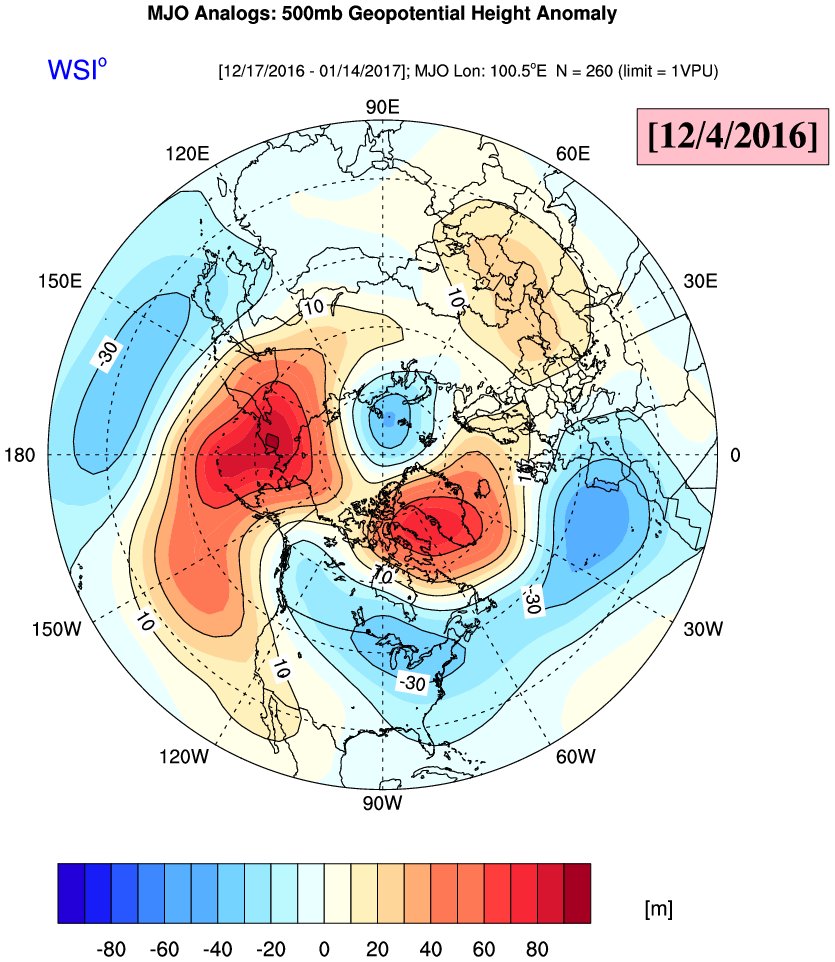
Ventrice MJO analog map for the next 3 -6 weeks. Interesting.........
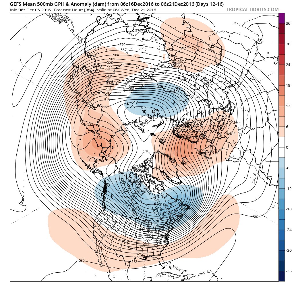
ANd GEFS saying cross polar flow here to stay until the 20th
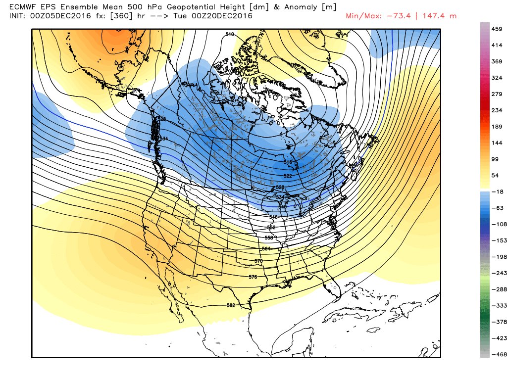
EPS says warm up huh??? AND might I add teh EPS saw this cold back before Turkey day and teh 500mb pattern evolution.
WPO by the EURO


ANd GEFS saying cross polar flow here to stay until the 20th

EPS says warm up huh??? AND might I add teh EPS saw this cold back before Turkey day and teh 500mb pattern evolution.

WPO by the EURO


_________________
Mugs
AKA:King: Snow Weenie
Self Proclaimed
WINTER 2014-15 : 55.12" +.02 for 6 coatings (avg. 35")
WINTER 2015-16 Total - 29.8" (Avg 35")
WINTER 2016-17 : 39.5" so far

amugs- Advanced Forecaster - Mod

- Posts : 15156
Reputation : 213
Join date : 2013-01-07
Age : 54
Location : Hillsdale,NJ
 Re: Long Range Thread 12.0
CFSv2 steadfast with January cold


_________________
Mugs
AKA:King: Snow Weenie
Self Proclaimed
WINTER 2014-15 : 55.12" +.02 for 6 coatings (avg. 35")
WINTER 2015-16 Total - 29.8" (Avg 35")
WINTER 2016-17 : 39.5" so far

amugs- Advanced Forecaster - Mod

- Posts : 15156
Reputation : 213
Join date : 2013-01-07
Age : 54
Location : Hillsdale,NJ
 Re: Long Range Thread 12.0
amugs wrote:CFSv2 steadfast with January cold
I hope so mugs

skinsfan1177- Senior Enthusiast

- Posts : 4485
Reputation : 35
Join date : 2013-01-07
Age : 47
Location : Point Pleasant Boro
 Re: Long Range Thread 12.0
CMC and GFS got rid of the cutters. Lets see if this storm trends south as colder air comes rushing in.

Snow88- Senior Enthusiast

- Posts : 2193
Reputation : 4
Join date : 2013-01-09
Age : 36
Location : Brooklyn, NY
 Re: Long Range Thread 12.0
Very cold pattern developing in the long range

Snow88- Senior Enthusiast

- Posts : 2193
Reputation : 4
Join date : 2013-01-09
Age : 36
Location : Brooklyn, NY
 Re: Long Range Thread 12.0
Glad to see the GFS trend colder with the system on the 12th. I still feel like that's a pretty good storm opportunity for us since cold air is already in place. What's key for this system is for H5 not to close off over the Lakes. Keep it an open wave as it tracks east. Will be interesting to see how this unfolds on guidance. It would not be a major event, maybe a SECS or low-end storm.
_________________
_______________________________________________________________________________________________________
CLICK HERE to view NJ Strong Snowstorm Classifications
 Re: Long Range Thread 12.0
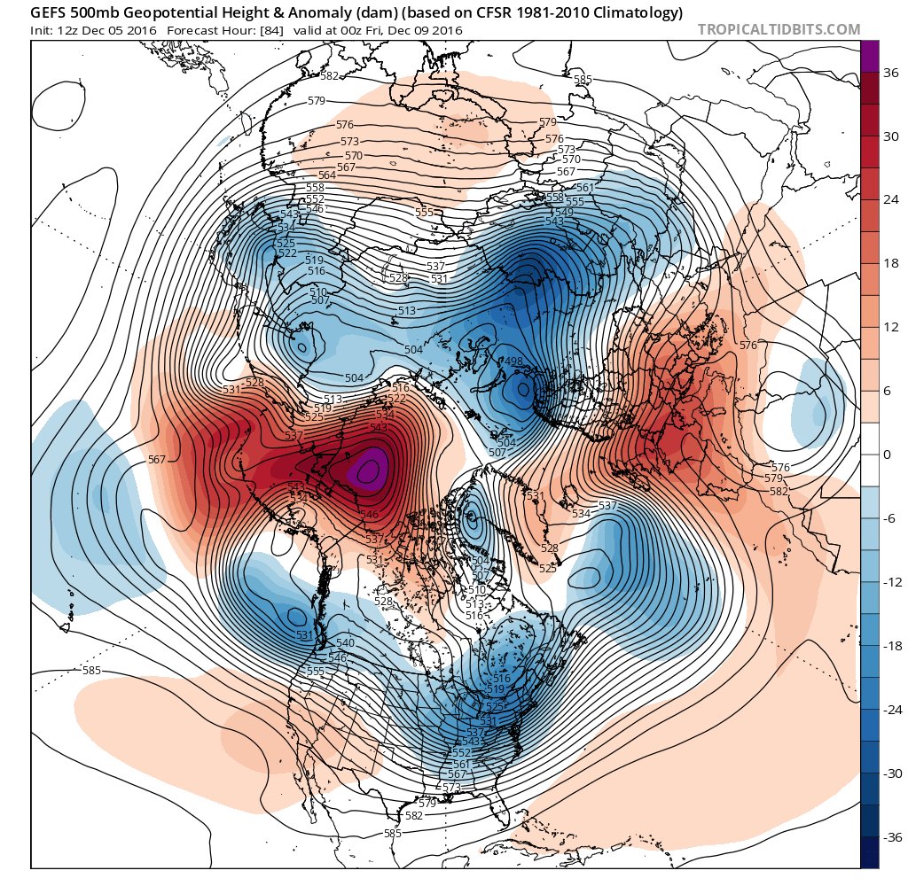
12Z GEFS barking shiver me timbers!! Look at that poleward ridge built over Alaska- that is the WPO which will be the driver of the pattern for cold.

_________________
Mugs
AKA:King: Snow Weenie
Self Proclaimed
WINTER 2014-15 : 55.12" +.02 for 6 coatings (avg. 35")
WINTER 2015-16 Total - 29.8" (Avg 35")
WINTER 2016-17 : 39.5" so far

amugs- Advanced Forecaster - Mod

- Posts : 15156
Reputation : 213
Join date : 2013-01-07
Age : 54
Location : Hillsdale,NJ
 Re: Long Range Thread 12.0
Euro has a lakes cutter for the 11-12th ( for now )

Snow88- Senior Enthusiast

- Posts : 2193
Reputation : 4
Join date : 2013-01-09
Age : 36
Location : Brooklyn, NY
 Re: Long Range Thread 12.0
MOMMA MIA this is cold air - Negtive 20's in the Northern Plains plus!!
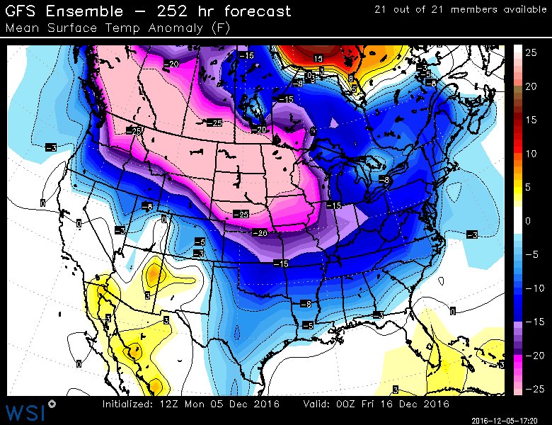
Look at what is on its heels for round 2 YIKES!!


Look at what is on its heels for round 2 YIKES!!

_________________
Mugs
AKA:King: Snow Weenie
Self Proclaimed
WINTER 2014-15 : 55.12" +.02 for 6 coatings (avg. 35")
WINTER 2015-16 Total - 29.8" (Avg 35")
WINTER 2016-17 : 39.5" so far

amugs- Advanced Forecaster - Mod

- Posts : 15156
Reputation : 213
Join date : 2013-01-07
Age : 54
Location : Hillsdale,NJ
 Re: Long Range Thread 12.0
EPO on the Euro looks great
The graphic from Wxbell has it crashing next week

Snow88- Senior Enthusiast

- Posts : 2193
Reputation : 4
Join date : 2013-01-09
Age : 36
Location : Brooklyn, NY
 Re: Long Range Thread 12.0
Regarding 12z EURO for storm on the 12th, it does some weird things with the upper energy in south central Canada. Tries to phase then it does not. Leading energy rides into NE CA and heights rise as a result along the EC. Need to see that energy dig more and track east, remain separate of the polar energy (no phasing)
_________________
_______________________________________________________________________________________________________
CLICK HERE to view NJ Strong Snowstorm Classifications
 Re: Long Range Thread 12.0
Our window of opportunity for wintry weather remains the 12th to 18th, and it can probably be shaved down to the 16th. I explained that for the system on the 12th we need the H5 energy to remain weak - dig into the CONUS - then track east bringing us a light to moderate snow event. GFS somewhat does it, EURO not so much. We track.
Beyond that, it begins to look very bleak again. The November QBO came out with a value of +14, suggesting westerly winds are fairly potent and will energize the Strat PV. EPS show exactly that in the LR over the Pole.

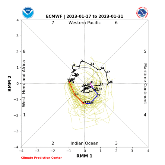
We see the AAM headed to negatives phases which points to the return of a La Nina-like pattern developing again after the 15th through Christmas. The MJO is already showing signs of going into phases 2, 3, then maybe 4 depending how strong the wave is. A phase 2 MJO during cold ENSO years brings back the Aleutian ridging, -PNA, +AO/NAO, SE Ridge pattern we saw at some point this season.

One positive is that -WPO/Nina ridge is not going to fade quickly. It's very strong and cut-off from the jet, so it will take its sweet time which is why I think our "cold" pattern could go until the 17th or so. But the cold Stratosphere will keep the AO/NAO positive regardless what happens with that ridge, and like I've said before, we need more than just that ridge in the west Arctic to help us out with a wintry event to the coast.
In sum, a good winter period between the 12th and 18th (+/- a day) but a return to above normal after that.
Beyond that, it begins to look very bleak again. The November QBO came out with a value of +14, suggesting westerly winds are fairly potent and will energize the Strat PV. EPS show exactly that in the LR over the Pole.

We see the AAM headed to negatives phases which points to the return of a La Nina-like pattern developing again after the 15th through Christmas. The MJO is already showing signs of going into phases 2, 3, then maybe 4 depending how strong the wave is. A phase 2 MJO during cold ENSO years brings back the Aleutian ridging, -PNA, +AO/NAO, SE Ridge pattern we saw at some point this season.


One positive is that -WPO/Nina ridge is not going to fade quickly. It's very strong and cut-off from the jet, so it will take its sweet time which is why I think our "cold" pattern could go until the 17th or so. But the cold Stratosphere will keep the AO/NAO positive regardless what happens with that ridge, and like I've said before, we need more than just that ridge in the west Arctic to help us out with a wintry event to the coast.
In sum, a good winter period between the 12th and 18th (+/- a day) but a return to above normal after that.
_________________
_______________________________________________________________________________________________________
CLICK HERE to view NJ Strong Snowstorm Classifications
 Re: Long Range Thread 12.0
The euro weeklies show a nice winter pattern through week 2 of December. By week 3, an abrupt flip to warmer than normal pattern.
Looks like it's going to be a normal to above normal Christmas.
Looks like it's going to be a normal to above normal Christmas.
_________________
_______________________________________________________________________________________________________
CLICK HERE to view NJ Strong Snowstorm Classifications
 Re: Long Range Thread 12.0
Disregard my last post. Was looking at the wrong thing. Weeklies are actually cold through all of December. Weeklies week of Xmas look cold. I wish I could buy that ridge in the NE PAC. Game changer is accurate. Ignore the orange shading in east U.S. Contours show a trough over the area
[Img]http://www.usa-wx.com/forum/uploads/monthly_2016_12/tmp_18414-eps_z500_168h_nh_72121753006.png.3f1978d1caa06dea04e9c4acc5f10959.png[img]
[Img]http://www.usa-wx.com/forum/uploads/monthly_2016_12/tmp_18414-eps_z500_168h_nh_72121753006.png.3f1978d1caa06dea04e9c4acc5f10959.png[img]
_________________
_______________________________________________________________________________________________________
CLICK HERE to view NJ Strong Snowstorm Classifications
 Re: Long Range Thread 12.0
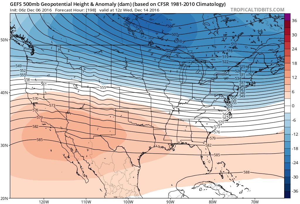
This is a nice gradient setting up here on the 12z GEFS

_________________
Mugs
AKA:King: Snow Weenie
Self Proclaimed
WINTER 2014-15 : 55.12" +.02 for 6 coatings (avg. 35")
WINTER 2015-16 Total - 29.8" (Avg 35")
WINTER 2016-17 : 39.5" so far

amugs- Advanced Forecaster - Mod

- Posts : 15156
Reputation : 213
Join date : 2013-01-07
Age : 54
Location : Hillsdale,NJ
 Re: Long Range Thread 12.0
MY GOD this is cold next week- we may see such since we have a reinforcing arctic shot of air that will NOT modify as the first one due to teh snow pack that will be built by the first arctic shot - teh ground will act as refrigerant to this air mass.


_________________
Mugs
AKA:King: Snow Weenie
Self Proclaimed
WINTER 2014-15 : 55.12" +.02 for 6 coatings (avg. 35")
WINTER 2015-16 Total - 29.8" (Avg 35")
WINTER 2016-17 : 39.5" so far

amugs- Advanced Forecaster - Mod

- Posts : 15156
Reputation : 213
Join date : 2013-01-07
Age : 54
Location : Hillsdale,NJ
 Re: Long Range Thread 12.0
amugs wrote:MY GOD this is cold next week- we may see such since we have a reinforcing arctic shot of air that will NOT modify as the first one due to teh snow pack that will be built by the first arctic shot - teh ground will act as refrigerant to this air mass.
Wow mugsy ok got the cold just need the white gold!

skinsfan1177- Senior Enthusiast

- Posts : 4485
Reputation : 35
Join date : 2013-01-07
Age : 47
Location : Point Pleasant Boro
 Re: Long Range Thread 12.0
We are finally getting into a cold and stormy pattern is there any snow chances during the weeks to come I am hoping we get a white Christmas
frank 638- Senior Enthusiast

- Posts : 2882
Reputation : 37
Join date : 2016-01-01
Age : 41
Location : bronx ny
 Re: Long Range Thread 12.0
The cold will come (piano, piano ... si va lutano) and when it does, BAM!

dkodgis- Senior Enthusiast

- Posts : 2693
Reputation : 98
Join date : 2013-12-29
 Re: Long Range Thread 12.0
dkodgis wrote:The cold will come (piano, piano ... si va lutano) and when it does, BAM!
That is my favorite saying by the way
_________________
_______________________________________________________________________________________________________
CLICK HERE to view NJ Strong Snowstorm Classifications
 Re: Long Range Thread 12.0
High temps on December 15th
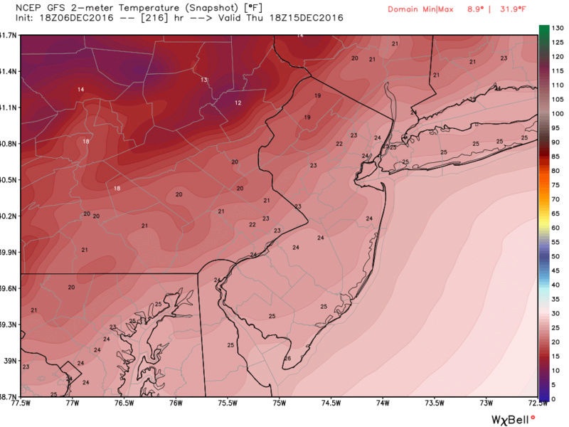

_________________
_______________________________________________________________________________________________________
CLICK HERE to view NJ Strong Snowstorm Classifications
 Re: Long Range Thread 12.0
Between this week and next, there's lots of cold weather coming but I'm having trouble finding a snowstorm in this pattern.The threat I've been speaking about on the 12th is fading but I remain intrigued. The sad news is this could go to waste because it should warm up again by the 20th through Christmas and New Years. So if we don't take advantage of the cold these next 10 to 13 days then we may not see snow until next month at some point, and I'm not even thrilled about January at this moment
_________________
_______________________________________________________________________________________________________
CLICK HERE to view NJ Strong Snowstorm Classifications
 Re: Long Range Thread 12.0
isn't that also when u said u feel there may be a storm? Wow cold for highs.Frank_Wx wrote:High temps on December 15th

jmanley32- Senior Enthusiast

- Posts : 20646
Reputation : 108
Join date : 2013-12-12
Age : 43
Location : Yonkers, NY
Page 32 of 40 •  1 ... 17 ... 31, 32, 33 ... 36 ... 40
Page 32 of 40
Permissions in this forum:
You cannot reply to topics in this forum
 Home
Home