June Obs & Discussion
+12
docstox12
frank 638
dkodgis
weatherwatchermom
essexcountypete
Dunnzoo
Frank_Wx
sroc4
jmanley32
aiannone
billg315
amugs
16 posters
Page 1 of 5 • 1, 2, 3, 4, 5 
 June Obs & Discussion
Peeps - the official meteorological summer has begun.
What a way to begin this with temps hitting a low of 44* here this morning.
Looks to be warm at the end of this weekend with temps in the mid to upper 80's with some areas of Central NJ hitting 90 or getting close to it then another cool shot swing in from Canada.
Wed

Thursday

Sunday and trough swings in

We have the MJO wave driving the pattern in phases 2 and then possibly 3 - for the 1000000x where were you in this phase for WINTER!!!
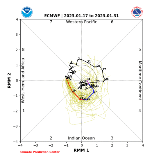

Phase 2 is chilly and 3 is warm -- this is the opposite of winter for phase 3.
Warmth returns again beginning of next week

What a way to begin this with temps hitting a low of 44* here this morning.
Looks to be warm at the end of this weekend with temps in the mid to upper 80's with some areas of Central NJ hitting 90 or getting close to it then another cool shot swing in from Canada.
Wed

Thursday

Sunday and trough swings in

We have the MJO wave driving the pattern in phases 2 and then possibly 3 - for the 1000000x where were you in this phase for WINTER!!!


Phase 2 is chilly and 3 is warm -- this is the opposite of winter for phase 3.
Warmth returns again beginning of next week

_________________
Mugs
AKA:King: Snow Weenie
Self Proclaimed
WINTER 2014-15 : 55.12" +.02 for 6 coatings (avg. 35")
WINTER 2015-16 Total - 29.8" (Avg 35")
WINTER 2016-17 : 39.5" so far

amugs- Advanced Forecaster - Mod

- Posts : 15156
Reputation : 213
Join date : 2013-01-07
Age : 54
Location : Hillsdale,NJ
 Re: June Obs & Discussion
Grand Solar Minimum
Spotless Days
Current Stretch: 30 days
2020 total: 121 days (79%)
2019 total: 281 days (77%)
2018 total: 221 days (61%)
2017 total: 104 days (28%)
Notilucent clouds are on the rise and purplish sunsets are too due to these puffers and the low solar/no sunspots. Jet stream is extreme and very steep, wavy .
We have areas in the Middle East adn Africa that are seeing historic cold, snow this past winter and now rains and flooding.
Geomagnetic poles are shifting and on the move which in the past resulted in natural disasters.
24,000, 12,000, 8,000, 4000, 2000, 1000, 800, 440, 220, 100, 22, & 11 year natural sun cycles and planetary alignments are converging.
Some are level 2 eruptions - minor but a very active period since 2018!!!!
Volcano Activity Summary for 31 May 2020:
Currently erupting:
Aso (central Kyushu, Japan): Volcanic Ash Advisory (updated 14 May 2020)
Dukono (Halmahera): Volcanic Ash Advisory (updated 26 May 2020)
Ebeko (Paramushir Island): Volcanic Ash Advisory (updated 12 May 2020)
Erebus (Antarctica): active lava lake in summit crater (updated 8 Dec 2014)
Erta Ale (Danakil depression, Ethiopia): new fissure vent on lower ESE flank with new lava flows (updated 19 Aug 2019)
Etna (Sicily, Italy): strombolian activity continues (updated 22 May 2020)
Fuego (Guatemala): Volcanic Ash Advisory (updated 25 May 2020)
Ibu (Halmahera, Indonesia): Volcanic Ash Advisory (updated 18 May 2020)
Karangetang (Siau Island, Sangihe Islands, Indonesia): Volcanic Ash Advisory (updated 2 Apr 2020)
Klyuchevskoy (Kamchatka): Volcanic Ash Advisory (updated 20 May 2020)
Masaya (Nicaragua): minor ashfall (updated 24 Oct 2019)
Merapi (Central Java, Indonesia): intermittent vulcanian explosions, slow lava dome growth with incandescent avalanches in summit crater (updated 4 May 2020)
Nishino-shima (Volcano Islands, Japan): effusion of lava flows from summit vent, reaching the sea (updated 29 Jan 2020)
Nyiragongo (DRCongo): new vent on crater floor (updated 7 Aug 2019)
Pacaya (Guatemala): strombolian activity continues (updated 25 May 2020)
Popocatépetl (Central Mexico): Volcanic Ash Advisory (updated 22 May 2020)
Reventador (Ecuador): Volcanic Ash Advisory (updated 28 May 2020)
Sabancaya (Peru): Volcanic Ash Advisory (updated 20 May 2020)
Sakurajima (Kyushu, Japan): explosive activity continues; emissions to 14,000 ft (updated 27 May 2020)
Sangay (Ecuador): Volcanic Ash Advisory (updated 12 May 2020)
Santiaguito (Guatemala): actively growing lava dome (updated 11 May 2020)
Semeru (East Java, Indonesia): Volcanic Ash Advisory (updated 18 May 2020)
Shiveluch (Kamchatka): Volcanic Ash Advisory (updated 29 May 2020)
Stromboli (Eolian Islands, Italy): lava overflow on Sciara del Fuoco, frequent strombolian explosions (updated 15 Apr 2020)
Yasur (Tanna Island, Vanuatu): minor ash emissions (updated 21 May 2020)
Eruption warning / minor activity:
Barren Island (Indian Ocean): mild explosive activity from summit cone (updated 6 Nov 2019)
Karymsky (Kamchatka): Volcanic Ash Advisory (updated 27 May 2020)
Kerinci (Sumatra): activity resumes (updated 16 Apr 2020)
Krakatau (Sunda Strait, Indonesia): Volcanic Ash Advisory (updated 8 May 2020)
Kuchinoerabu-jima (Ryukyu Islands): Volcanic Ash Advisory (updated 8 May 2020)
Nevado del Ruiz (Colombia): explosive activity continues (updated 1 May 2020)
Nevados de Chillán (Central Chile): Volcanic Ash Advisory (updated 19 May 2020)
Nyamuragira (DRCongo): the eruption continues (updated 12 Nov 2019)
Rincón de la Vieja (Costa Rica): phreatic eruptions this week (updated 28 May 2020)
Sangeang Api (Indonesia): Volcanic Ash Advisory (updated 28 Dec 2019)
Suwanose-jima (Ryukyu Islands): Volcanic Ash Advisory (updated 22 May 2020)
Villarrica (Central Chile): Alert level raised to Orange (updated 30 Jan 2020)
_________________
Mugs
AKA:King: Snow Weenie
Self Proclaimed
WINTER 2014-15 : 55.12" +.02 for 6 coatings (avg. 35")
WINTER 2015-16 Total - 29.8" (Avg 35")
WINTER 2016-17 : 39.5" so far

amugs- Advanced Forecaster - Mod

- Posts : 15156
Reputation : 213
Join date : 2013-01-07
Age : 54
Location : Hillsdale,NJ
 Re: June Obs & Discussion
Strong T’Storm rolling through my area right now. No wind but heavy rain and LOTS of lightning and thunder. Just woke me up. Radar shows a line of cells moving training over this part of the state so may last a while here.

billg315- Advanced Forecaster - Mod

- Posts : 4564
Reputation : 185
Join date : 2015-01-24
Age : 50
Location : Flemington, NJ

billg315- Advanced Forecaster - Mod

- Posts : 4564
Reputation : 185
Join date : 2015-01-24
Age : 50
Location : Flemington, NJ

aiannone- Senior Enthusiast - Mod

- Posts : 4828
Reputation : 92
Join date : 2013-01-07
Location : Saint James, LI (Northwest Suffolk Co.)
 Re: June Obs & Discussion
Yeah we are in enhanced spc risk today which isn't common 30% wor winds over 60mph, 15% chance hail and 2% chance tornado (these all within 25 mile radius of a single point) Never really understood that so that's basically any area? lol Just say that then.

jmanley32- Senior Enthusiast

- Posts : 20646
Reputation : 108
Join date : 2013-12-12
Age : 43
Location : Yonkers, NY
 Re: June Obs & Discussion
Looks like the line is aimed much further south and is quite small, doesnt look to effect northern NJ or NY/LI, or might it expand more north (the line) Watch up already and does not include any of NY but just to the south.

jmanley32- Senior Enthusiast

- Posts : 20646
Reputation : 108
Join date : 2013-12-12
Age : 43
Location : Yonkers, NY
 Re: June Obs & Discussion
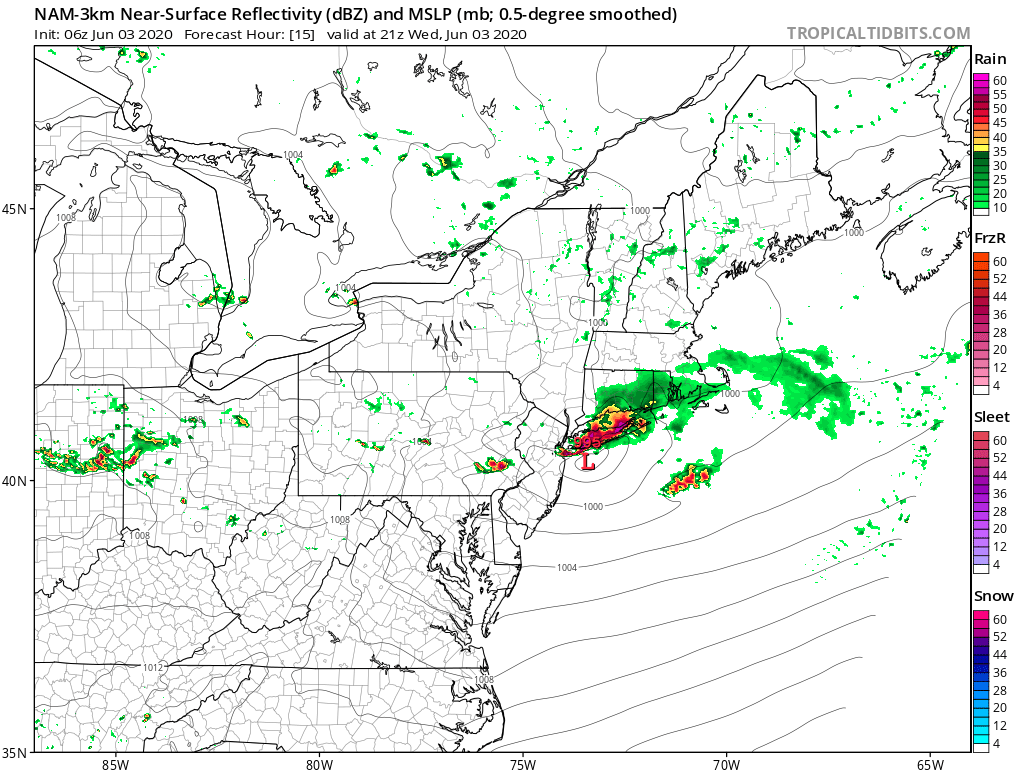
Appears the NAM even at 12z is way off with the actual placement of the line, oh well that sux, was hoping for some severe storms. The HRRR has the placement where it actually shows the line on radar now so I would discount the NAm completely.

jmanley32- Senior Enthusiast

- Posts : 20646
Reputation : 108
Join date : 2013-12-12
Age : 43
Location : Yonkers, NY
 Re: June Obs & Discussion
jmanley32 wrote:Appears the NAM even at 12z is way off with the actual placement of the line, oh well that sux, was hoping for some severe storms. The HRRR has the placement where it actually shows the line on radar now so I would discount the NAm completely.
Discounted completely?
_________________
"In weather and in life, there's no winning and losing; there's only winning and learning."
WINTER 2012/2013 TOTALS 43.65"WINTER 2017/2018 TOTALS 62.85" WINTER 2022/2023 TOTALS 4.9"
WINTER 2013/2014 TOTALS 64.85"WINTER 2018/2019 TOTALS 14.25" WINTER 2023/2024 TOTALS 13.1"
WINTER 2014/2015 TOTALS 71.20"WINTER 2019/2020 TOTALS 6.35" WINTER 2024/2025 TOTALS 0.00
WINTER 2015/2016 TOTALS 35.00"WINTER 2020/2021 TOTALS 37.75"
WINTER 2016/2017 TOTALS 42.25"WINTER 2021/2022 TOTALS 31.65"

sroc4- Admin

- Posts : 8458
Reputation : 302
Join date : 2013-01-07
Location : Wading River, LI
 Re: June Obs & Discussion
Well look at the placement of the current line and the placement on the NAM, and the placement on the HRRR and the current radar. I dont think the line is suddenly going to jump to where the NAM is do you? LOLsroc4 wrote:jmanley32 wrote:Appears the NAM even at 12z is way off with the actual placement of the line, oh well that sux, was hoping for some severe storms. The HRRR has the placement where it actually shows the line on radar now so I would discount the NAm completely.
Discounted completely?

jmanley32- Senior Enthusiast

- Posts : 20646
Reputation : 108
Join date : 2013-12-12
Age : 43
Location : Yonkers, NY
 Re: June Obs & Discussion
Jesus is that a Derecho!? Holy wow, that line is moving nearly 90mph in partS!! And all the warnings have winds from 70-85 mph, if it isn't a derecho it certainly will pack a similar punch, any one getting word of the severity behind it? Be safe people that are central to southern Jersey it's knocking on your door!! Why is it so unstable out there? Its not that hot and its been cloudy.

jmanley32- Senior Enthusiast

- Posts : 20646
Reputation : 108
Join date : 2013-12-12
Age : 43
Location : Yonkers, NY
 Re: June Obs & Discussion
billg315 wrote:Strong T’Storm rolling through my area right now. No wind but heavy rain and LOTS of lightning and thunder. Just woke me up. Radar shows a line of cells moving training over this part of the state so may last a while here.
Wow
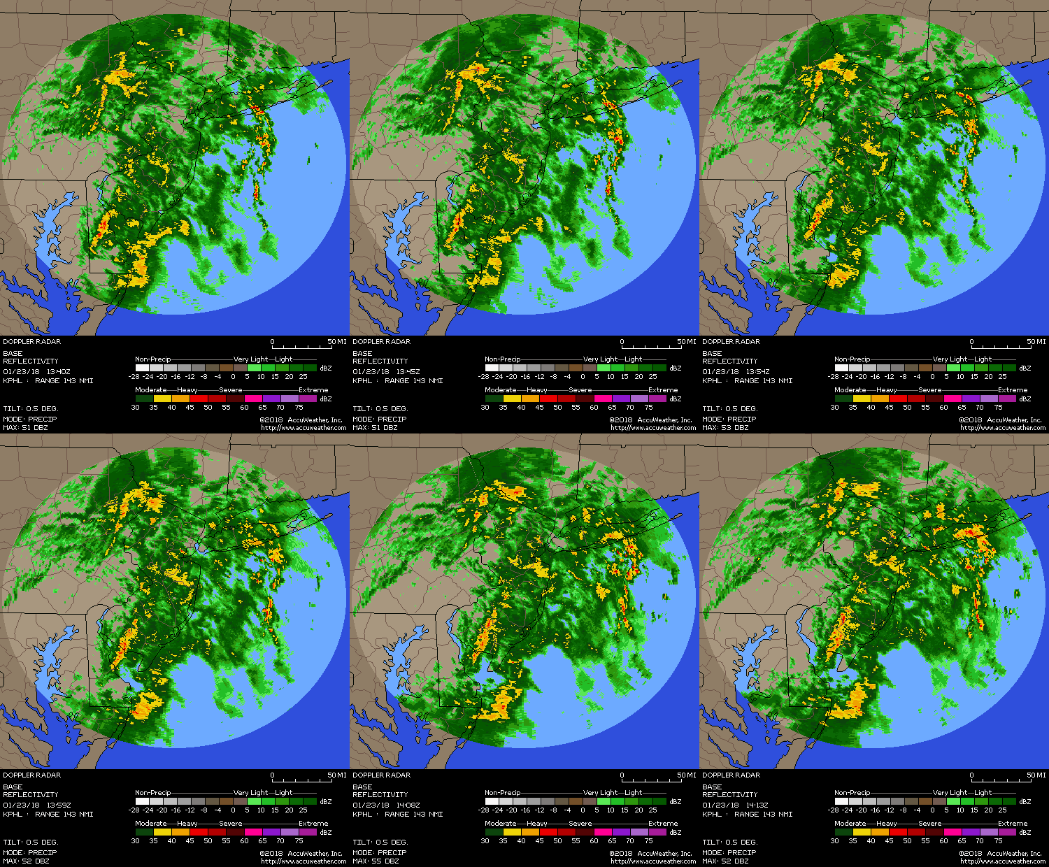
Let us know their intensity when they get to ya
_________________
_______________________________________________________________________________________________________
CLICK HERE to view NJ Strong Snowstorm Classifications
 Re: June Obs & Discussion
https://radar.weather.gov/Conus/Loop/northeast_loop.gif
_________________
_______________________________________________________________________________________________________
CLICK HERE to view NJ Strong Snowstorm Classifications
 Re: June Obs & Discussion
Frank_Wx wrote:billg315 wrote:Strong T’Storm rolling through my area right now. No wind but heavy rain and LOTS of lightning and thunder. Just woke me up. Radar shows a line of cells moving training over this part of the state so may last a while here.
Wow
Let us know their intensity when they get to ya
What radar is that? Thats not current radar, its not raining here.

jmanley32- Senior Enthusiast

- Posts : 20646
Reputation : 108
Join date : 2013-12-12
Age : 43
Location : Yonkers, NY
 Re: June Obs & Discussion
haha the date on that radar says 1/23/18!
_________________
Janet
Snowfall winter of 2023-2024 17.5"
Snowfall winter of 2022-2023 6.0"
Snowfall winter of 2021-2022 17.6" 1" sleet 2/25/22
Snowfall winter of 2020-2021 51.1"
Snowfall winter of 2019-2020 8.5"
Snowfall winter of 2018-2019 25.1"
Snowfall winter of 2017-2018 51.9"
Snowfall winter of 2016-2017 45.6"
Snowfall winter of 2015-2016 29.5"
Snowfall winter of 2014-2015 50.55"
Snowfall winter of 2013-2014 66.5"
Dunnzoo- Senior Enthusiast - Mod

- Posts : 4937
Reputation : 68
Join date : 2013-01-11
Age : 62
Location : Westwood, NJ
 Re: June Obs & Discussion
Is the line to the south it or is there more to come further north? They just released updated SPC.

jmanley32- Senior Enthusiast

- Posts : 20646
Reputation : 108
Join date : 2013-12-12
Age : 43
Location : Yonkers, NY
 Re: June Obs & Discussion
Dunnzoo wrote:haha the date on that radar says 1/23/18!
WTH Peeps - fake news has infiltrated here here as well?? NOOOOOOO!!
In CNJ Battin' down the hatches peeps - INCOMING
Image/radar doesn't load on here properly - something is awry with this. Here is the link
http://sirocco.accuweather.com/nxssa_r1_h_500x620d/r1h/inxr1Kphla_h.gif
_________________
Mugs
AKA:King: Snow Weenie
Self Proclaimed
WINTER 2014-15 : 55.12" +.02 for 6 coatings (avg. 35")
WINTER 2015-16 Total - 29.8" (Avg 35")
WINTER 2016-17 : 39.5" so far

amugs- Advanced Forecaster - Mod

- Posts : 15156
Reputation : 213
Join date : 2013-01-07
Age : 54
Location : Hillsdale,NJ
 Re: June Obs & Discussion
Wider view


_________________
Mugs
AKA:King: Snow Weenie
Self Proclaimed
WINTER 2014-15 : 55.12" +.02 for 6 coatings (avg. 35")
WINTER 2015-16 Total - 29.8" (Avg 35")
WINTER 2016-17 : 39.5" so far

amugs- Advanced Forecaster - Mod

- Posts : 15156
Reputation : 213
Join date : 2013-01-07
Age : 54
Location : Hillsdale,NJ

billg315- Advanced Forecaster - Mod

- Posts : 4564
Reputation : 185
Join date : 2015-01-24
Age : 50
Location : Flemington, NJ
 Re: June Obs & Discussion
Rain is heavy here with gusty winds, but there was much more lightning and thunder with last night’s storms that came through around 1 am. That was a noisy one. Lol. I imagine there is more lightning with the storms south of here from Princeton to Philly.

billg315- Advanced Forecaster - Mod

- Posts : 4564
Reputation : 185
Join date : 2015-01-24
Age : 50
Location : Flemington, NJ
 Re: June Obs & Discussion
I am hearing about very bad damage behind this....

jmanley32- Senior Enthusiast

- Posts : 20646
Reputation : 108
Join date : 2013-12-12
Age : 43
Location : Yonkers, NY
 Re: June Obs & Discussion
jmanley32 wrote:Jesus is that a Derecho!? Holy wow, that line is moving nearly 90mph in partS!! And all the warnings have winds from 70-85 mph, if it isn't a derecho it certainly will pack a similar punch, any one getting word of the severity behind it? Be safe people that are central to southern Jersey it's knocking on your door!! Why is it so unstable out there? Its not that hot and its been cloudy.
First thing I thought when I saw the radar, then I came here. Wow.
Am I crazy or is this a path we've seen from a Derecho previously?

essexcountypete- Pro Enthusiast

- Posts : 783
Reputation : 12
Join date : 2013-12-09
Location : Bloomfield, NJ
 Re: June Obs & Discussion
amugs wrote:Dunnzoo wrote:haha the date on that radar says 1/23/18!
WTH Peeps - fake news has infiltrated here here as well?? NOOOOOOO!!
In CNJ Battin' down the hatches peeps - INCOMING
Image/radar doesn't load on here properly - something is awry with this. Here is the link
http://sirocco.accuweather.com/nxssa_r1_h_500x620d/r1h/inxr1Kphla_h.gif
yes was outside gardening and got very dark..secured everything and came in raining right now winds picking up

weatherwatchermom- Senior Enthusiast

- Posts : 3895
Reputation : 78
Join date : 2014-11-25
Location : Hazlet Township, NJ
 Re: June Obs & Discussion
jmanley32 wrote:Well look at the placement of the current line and the placement on the NAM, and the placement on the HRRR and the current radar. I dont think the line is suddenly going to jump to where the NAM is do you? LOLsroc4 wrote:jmanley32 wrote:Appears the NAM even at 12z is way off with the actual placement of the line, oh well that sux, was hoping for some severe storms. The HRRR has the placement where it actually shows the line on radar now so I would discount the NAm completely.
Discounted completely?
Totally different entities moving through at diff times. 2pm ish HRRR vs 5pm is on the NAM
_________________
"In weather and in life, there's no winning and losing; there's only winning and learning."
WINTER 2012/2013 TOTALS 43.65"WINTER 2017/2018 TOTALS 62.85" WINTER 2022/2023 TOTALS 4.9"
WINTER 2013/2014 TOTALS 64.85"WINTER 2018/2019 TOTALS 14.25" WINTER 2023/2024 TOTALS 13.1"
WINTER 2014/2015 TOTALS 71.20"WINTER 2019/2020 TOTALS 6.35" WINTER 2024/2025 TOTALS 0.00
WINTER 2015/2016 TOTALS 35.00"WINTER 2020/2021 TOTALS 37.75"
WINTER 2016/2017 TOTALS 42.25"WINTER 2021/2022 TOTALS 31.65"

sroc4- Admin

- Posts : 8458
Reputation : 302
Join date : 2013-01-07
Location : Wading River, LI
 Re: June Obs & Discussion
sroc4 wrote:jmanley32 wrote:Well look at the placement of the current line and the placement on the NAM, and the placement on the HRRR and the current radar. I dont think the line is suddenly going to jump to where the NAM is do you? LOLsroc4 wrote:jmanley32 wrote:Appears the NAM even at 12z is way off with the actual placement of the line, oh well that sux, was hoping for some severe storms. The HRRR has the placement where it actually shows the line on radar now so I would discount the NAm completely.
Discounted completely?
Totally different entities moving through at diff times. 2pm ish HRRR vs 5pm is on the NAM
So there may be a similar line like on the NAM in a few hours? But the NAM did NOT show the morning line at all is why i thought that.

jmanley32- Senior Enthusiast

- Posts : 20646
Reputation : 108
Join date : 2013-12-12
Age : 43
Location : Yonkers, NY
Page 1 of 5 • 1, 2, 3, 4, 5 
Permissions in this forum:
You cannot reply to topics in this forum
 Home
Home
