Long Range Discussion 20(20) (Ha!)
+43
toople
TheAresian
Koroptim
Bkdude
essexcountypete
chief7
GreyBeard
crippo84
hyde345
lglickman1
Zhukov1945
bloc1357
SENJsnowman
Snow88
CPcantmeasuresnow
bobjohnsonforthehall
weatherwatchermom
skinsfan1177
billg315
SoulSingMG
phil155
aiannone
nutleyblizzard
Math23x7
Wheezer
Irish
Frank_Wx
mwilli
Grselig
Isotherm
heehaw453
jimv45
frank 638
docstox12
rb924119
sroc4
HectorO
algae888
dkodgis
Radz
jmanley32
amugs
Dunnzoo
47 posters
Page 1 of 30
Page 1 of 30 • 1, 2, 3 ... 15 ... 30 
 Long Range Discussion 20(20) (Ha!)
Ready, set, go!
_________________
Janet
Snowfall winter of 2023-2024 17.5"
Snowfall winter of 2022-2023 6.0"
Snowfall winter of 2021-2022 17.6" 1" sleet 2/25/22
Snowfall winter of 2020-2021 51.1"
Snowfall winter of 2019-2020 8.5"
Snowfall winter of 2018-2019 25.1"
Snowfall winter of 2017-2018 51.9"
Snowfall winter of 2016-2017 45.6"
Snowfall winter of 2015-2016 29.5"
Snowfall winter of 2014-2015 50.55"
Snowfall winter of 2013-2014 66.5"
Dunnzoo- Senior Enthusiast - Mod

- Posts : 4938
Reputation : 68
Join date : 2013-01-11
Age : 62
Location : Westwood, NJ
 Re: Long Range Discussion 20(20) (Ha!)
POST #2
AO LR on EURO
.png)
GEFS

NEW GEFS EXTENDED
EPO - WOOP WOOP - neutral to Negative allows for cooler conditions and colder conditions to enter from teh arctic into the Central and Eastern US
EURO WEEKLEIS says I concur but ia m slightly positive


PNA GEFS Keeps it positive

SUN SOLAR HIT 200 SPOTLESS DAYS!!! The two new solar sunspots are very weak and one doesn't even have dark spots but has the polarity so they are classifying them as sunspots. This si 5-6th time this year they have done this. I call BS.
Daily Sun: 10 Oct 20
Sunspots AR2774 and AR2775 belong to new Solar Cycle 25, but they are small and pose no threat for strong solar flares. Credit: SDO/HMI
Sunspot number: 24
What is the sunspot number?
Updated 10 Oct 2020
Spotless Days
Current Stretch: 0 days
2020 total: 203 days (72%)
2019 total: 281 days (77%)
2018 total: 221 days (61%)
2017 total: 104 days (28%)
2016 total: 32 days (9%)
2015 total: 0 days (0%)
2014 total: 1 day (<1%)
2013 total: 0 days (0%)
2012 total: 0 days (0%)
2011 total: 2 days (<1%)
2010 total: 51 days (14%)
2009 total: 260 days (71%)
2008 total: 268 days (73%)
2007 total: 152 days (42%)
2006 total: 70 days (19%)
Updated 10 Oct 2020
We'll see who is better and more right in late Oct and then mid Nov!!
This means cooler, colder weather shots. Below Normal temps overall.
AO LR on EURO
.png)
GEFS

NEW GEFS EXTENDED
EPO - WOOP WOOP - neutral to Negative allows for cooler conditions and colder conditions to enter from teh arctic into the Central and Eastern US
EURO WEEKLEIS says I concur but ia m slightly positive


PNA GEFS Keeps it positive

SUN SOLAR HIT 200 SPOTLESS DAYS!!! The two new solar sunspots are very weak and one doesn't even have dark spots but has the polarity so they are classifying them as sunspots. This si 5-6th time this year they have done this. I call BS.
Daily Sun: 10 Oct 20
Sunspots AR2774 and AR2775 belong to new Solar Cycle 25, but they are small and pose no threat for strong solar flares. Credit: SDO/HMI
Sunspot number: 24
What is the sunspot number?
Updated 10 Oct 2020
Spotless Days
Current Stretch: 0 days
2020 total: 203 days (72%)
2019 total: 281 days (77%)
2018 total: 221 days (61%)
2017 total: 104 days (28%)
2016 total: 32 days (9%)
2015 total: 0 days (0%)
2014 total: 1 day (<1%)
2013 total: 0 days (0%)
2012 total: 0 days (0%)
2011 total: 2 days (<1%)
2010 total: 51 days (14%)
2009 total: 260 days (71%)
2008 total: 268 days (73%)
2007 total: 152 days (42%)
2006 total: 70 days (19%)
Updated 10 Oct 2020
We'll see who is better and more right in late Oct and then mid Nov!!
This means cooler, colder weather shots. Below Normal temps overall.
_________________
Mugs
AKA:King: Snow Weenie
Self Proclaimed
WINTER 2014-15 : 55.12" +.02 for 6 coatings (avg. 35")
WINTER 2015-16 Total - 29.8" (Avg 35")
WINTER 2016-17 : 39.5" so far

amugs- Advanced Forecaster - Mod

- Posts : 15157
Reputation : 213
Join date : 2013-01-07
Age : 54
Location : Hillsdale,NJ
 Re: Long Range Discussion 20(20) (Ha!)
_________________
Janet
Snowfall winter of 2023-2024 17.5"
Snowfall winter of 2022-2023 6.0"
Snowfall winter of 2021-2022 17.6" 1" sleet 2/25/22
Snowfall winter of 2020-2021 51.1"
Snowfall winter of 2019-2020 8.5"
Snowfall winter of 2018-2019 25.1"
Snowfall winter of 2017-2018 51.9"
Snowfall winter of 2016-2017 45.6"
Snowfall winter of 2015-2016 29.5"
Snowfall winter of 2014-2015 50.55"
Snowfall winter of 2013-2014 66.5"

Dunnzoo- Senior Enthusiast - Mod

- Posts : 4938
Reputation : 68
Join date : 2013-01-11
Age : 62
Location : Westwood, NJ
 Re: Long Range Discussion 20(20) (Ha!)
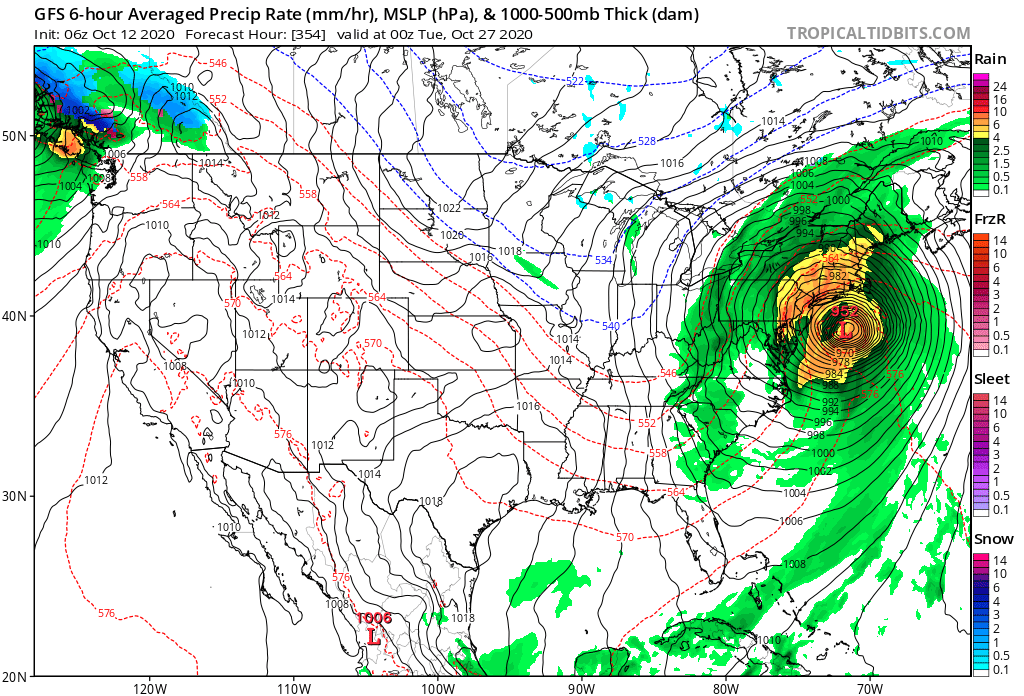
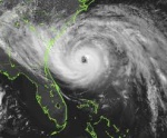
Yeah thats the morph of the hurricane from down south, whatever the "E" name is. Note the date and the size of that storm, hopefully not another Sandy, originates from the same place too...I highely doubt any kind of sandy turn but might be following a big storm come mid next week. (Fl looks in for it on many runs)

jmanley32- Senior Enthusiast

- Posts : 20648
Reputation : 108
Join date : 2013-12-12
Age : 43
Location : Yonkers, NY
 Re: Long Range Discussion 20(20) (Ha!)
Just read an article about the recently formed polar vortex being historically weak for this time of year, coupled with a weak La Niña, could spell an early active winter like December- fingers crossed! Maybe 2020 will deliver some good news for us winter weather weanies! Yeah I know it’s only October 
Radz- Pro Enthusiast

- Posts : 1028
Reputation : 17
Join date : 2013-01-12
Location : Cortlandt Manor NY
HectorO likes this post
 Re: Long Range Discussion 20(20) (Ha!)
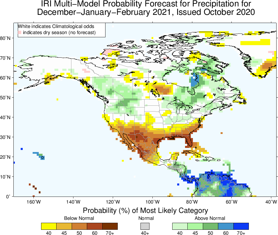
Looks much better than last winter so far if it is right


_________________
Mugs
AKA:King: Snow Weenie
Self Proclaimed
WINTER 2014-15 : 55.12" +.02 for 6 coatings (avg. 35")
WINTER 2015-16 Total - 29.8" (Avg 35")
WINTER 2016-17 : 39.5" so far

amugs- Advanced Forecaster - Mod

- Posts : 15157
Reputation : 213
Join date : 2013-01-07
Age : 54
Location : Hillsdale,NJ
 Re: Long Range Discussion 20(20) (Ha!)
_________________
Mugs
AKA:King: Snow Weenie
Self Proclaimed
WINTER 2014-15 : 55.12" +.02 for 6 coatings (avg. 35")
WINTER 2015-16 Total - 29.8" (Avg 35")
WINTER 2016-17 : 39.5" so far

amugs- Advanced Forecaster - Mod

- Posts : 15157
Reputation : 213
Join date : 2013-01-07
Age : 54
Location : Hillsdale,NJ
 Re: Long Range Discussion 20(20) (Ha!)
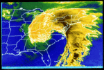
GFS honking on a storm for days now the week of the 25th, if the set up is correct it could be very interesting coastal.
Hybrid Coastal off the coast

Spawns the backside Coastal

Hybrid Coastal off the coast

Spawns the backside Coastal

_________________
Mugs
AKA:King: Snow Weenie
Self Proclaimed
WINTER 2014-15 : 55.12" +.02 for 6 coatings (avg. 35")
WINTER 2015-16 Total - 29.8" (Avg 35")
WINTER 2016-17 : 39.5" so far

amugs- Advanced Forecaster - Mod

- Posts : 15157
Reputation : 213
Join date : 2013-01-07
Age : 54
Location : Hillsdale,NJ
 Re: Long Range Discussion 20(20) (Ha!)
THIS WOUDL SHOCK PEEPS - FROST AND FREEZE to the GULF COAST - IF its true


_________________
Mugs
AKA:King: Snow Weenie
Self Proclaimed
WINTER 2014-15 : 55.12" +.02 for 6 coatings (avg. 35")
WINTER 2015-16 Total - 29.8" (Avg 35")
WINTER 2016-17 : 39.5" so far

amugs- Advanced Forecaster - Mod

- Posts : 15157
Reputation : 213
Join date : 2013-01-07
Age : 54
Location : Hillsdale,NJ
 Re: Long Range Discussion 20(20) (Ha!)
amugs wrote:THIS WOUDL SHOCK PEEPS - FROST AND FREEZE to the GULF COAST - IF its true
That rough has been delayed a couple of days but still on the maps.
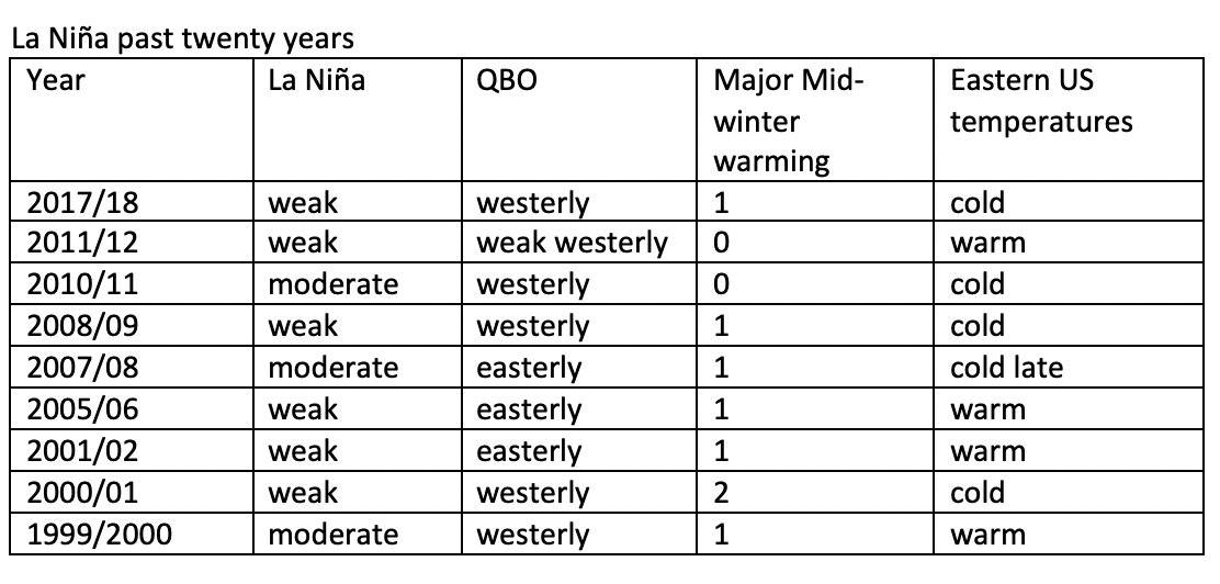
This is a very interesting to see. WE are in a weak Nina, with a westerly QBO and look at the winters with those 2 factors over the past 20 years. Doesn't mean cold winter is a lock but raises a brow for sure:
_________________
Mugs
AKA:King: Snow Weenie
Self Proclaimed
WINTER 2014-15 : 55.12" +.02 for 6 coatings (avg. 35")
WINTER 2015-16 Total - 29.8" (Avg 35")
WINTER 2016-17 : 39.5" so far

amugs- Advanced Forecaster - Mod

- Posts : 15157
Reputation : 213
Join date : 2013-01-07
Age : 54
Location : Hillsdale,NJ
 Re: Long Range Discussion 20(20) (Ha!)
_________________
Mugs
AKA:King: Snow Weenie
Self Proclaimed
WINTER 2014-15 : 55.12" +.02 for 6 coatings (avg. 35")
WINTER 2015-16 Total - 29.8" (Avg 35")
WINTER 2016-17 : 39.5" so far

amugs- Advanced Forecaster - Mod

- Posts : 15157
Reputation : 213
Join date : 2013-01-07
Age : 54
Location : Hillsdale,NJ
 Re: Long Range Discussion 20(20) (Ha!)
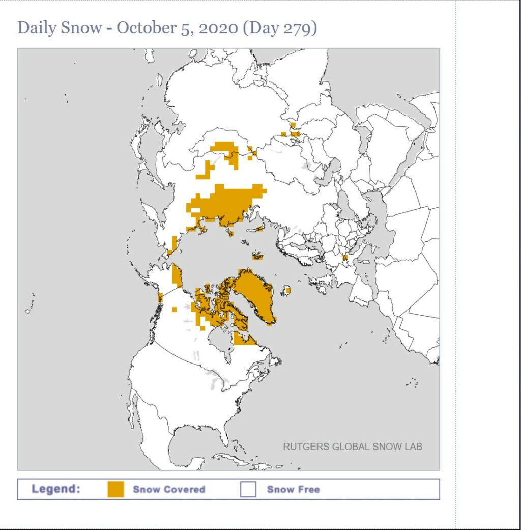
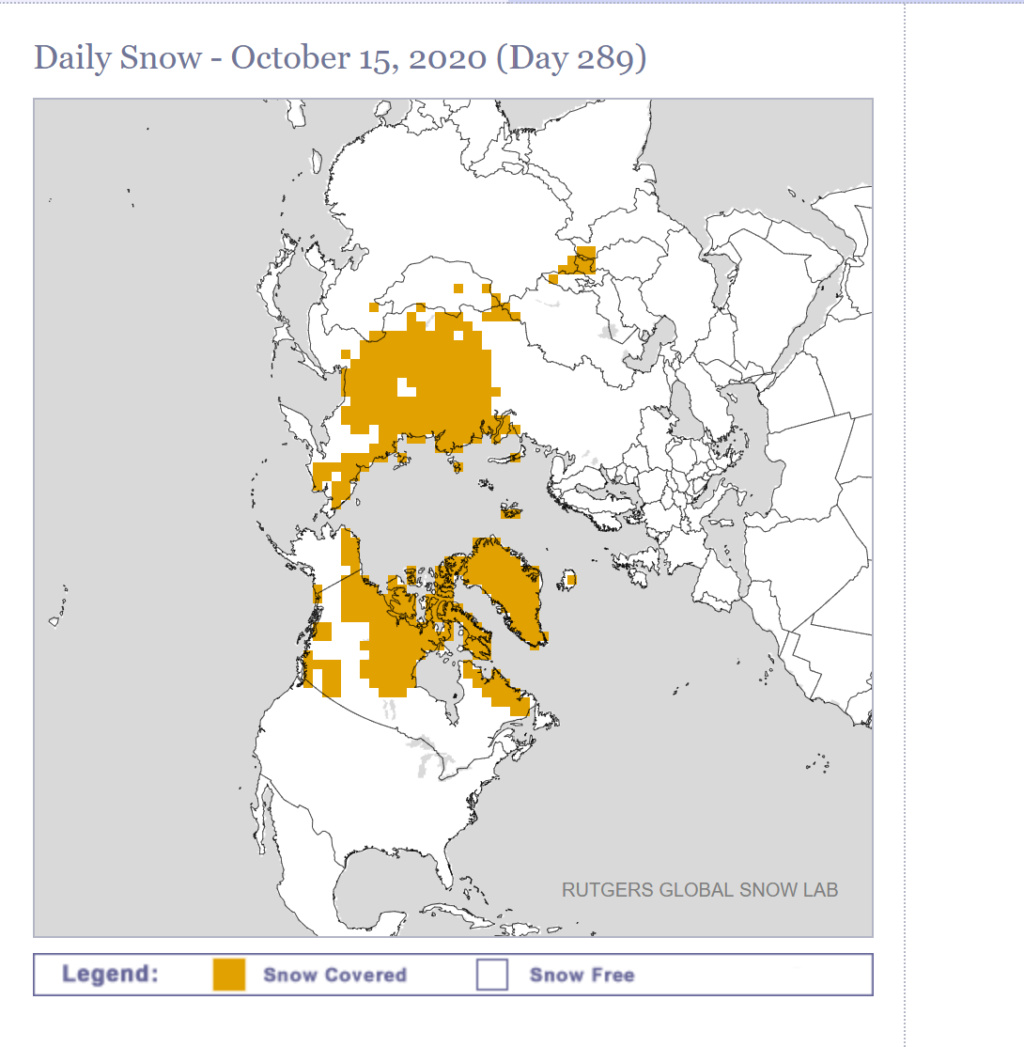
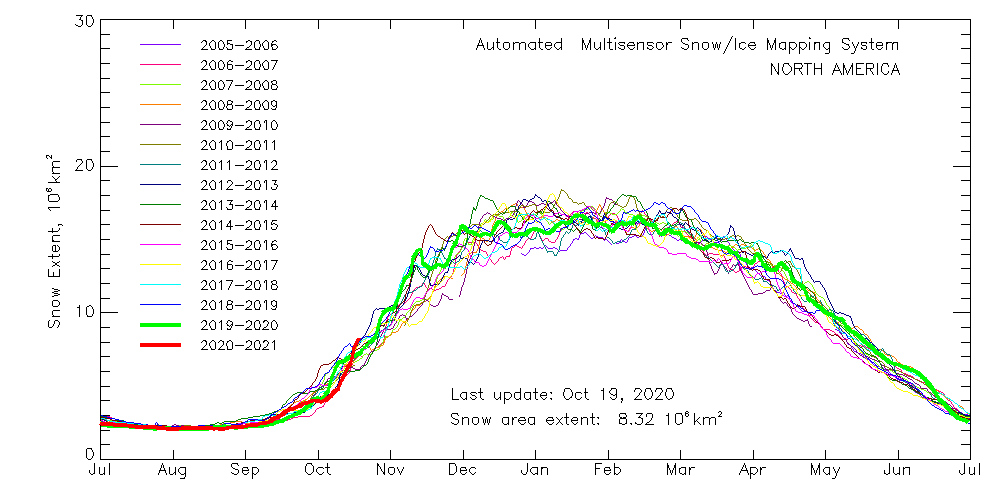
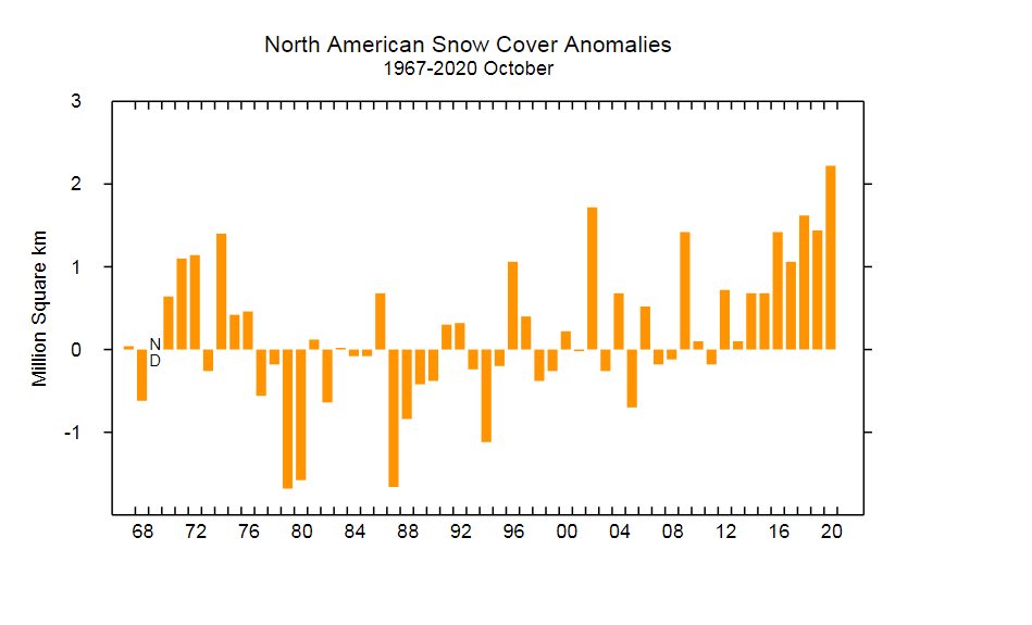
For the visual among us when it comes to snow covers here there everywhere
https://www.eldoradoweather.com/snow-ice-cover.html
https://www.eldoradoweather.com/snow-ice-cover.html

dkodgis- Senior Enthusiast

- Posts : 2694
Reputation : 98
Join date : 2013-12-29
 Re: Long Range Discussion 20(20) (Ha!)
A few thoughts as we are heading closer to Winter. Region 3.4 is now at -1.6 which is a moderate la nina and could approach -2 in December which would make it a strong La Nina. The waters off the California coast are extremely warm which is unprecedented with this strong of a la nina so I would be cautious using any analogs for past years. Also I am hearing the mjo could more often than not end up in phases 8 1 and 2 rather than the maritime continent this year do not know the effects of the mjo this winter with such a strong la nina. So far about 90% of winter forecast that I have seen are warm and snowless for our area

algae888- Advanced Forecaster

- Posts : 5311
Reputation : 46
Join date : 2013-02-05
Age : 62
Location : mt. vernon, new york
 Re: Long Range Discussion 20(20) (Ha!)
algae888 wrote:A few thoughts as we are heading closer to Winter. Region 3.4 is now at -1.6 which is a moderate la nina and could approach -2 in December which would make it a strong La Nina. The waters off the California coast are extremely warm which is unprecedented with this strong of a la nina so I would be cautious using any analogs for past years. Also I am hearing the mjo could more often than not end up in phases 8 1 and 2 rather than the maritime continent this year do not know the effects of the mjo this winter with such a strong la nina. So far about 90% of winter forecast that I have seen are warm and snowless for our area
Yeah, haven't seen any cold & snowy forecasts for this winter, but the way the squirrels are eating every pumpkin and stealing Halloween candy, they look like they are getting ready to hunker down for a long cold winter!
_________________
Janet
Snowfall winter of 2023-2024 17.5"
Snowfall winter of 2022-2023 6.0"
Snowfall winter of 2021-2022 17.6" 1" sleet 2/25/22
Snowfall winter of 2020-2021 51.1"
Snowfall winter of 2019-2020 8.5"
Snowfall winter of 2018-2019 25.1"
Snowfall winter of 2017-2018 51.9"
Snowfall winter of 2016-2017 45.6"
Snowfall winter of 2015-2016 29.5"
Snowfall winter of 2014-2015 50.55"
Snowfall winter of 2013-2014 66.5"

Dunnzoo- Senior Enthusiast - Mod

- Posts : 4938
Reputation : 68
Join date : 2013-01-11
Age : 62
Location : Westwood, NJ
 Re: Long Range Discussion 20(20) (Ha!)
Dunnzoo wrote:algae888 wrote:A few thoughts as we are heading closer to Winter. Region 3.4 is now at -1.6 which is a moderate la nina and could approach -2 in December which would make it a strong La Nina. The waters off the California coast are extremely warm which is unprecedented with this strong of a la nina so I would be cautious using any analogs for past years. Also I am hearing the mjo could more often than not end up in phases 8 1 and 2 rather than the maritime continent this year do not know the effects of the mjo this winter with such a strong la nina. So far about 90% of winter forecast that I have seen are warm and snowless for our area
Yeah, haven't seen any cold & snowy forecasts for this winter, but the way the squirrels are eating every pumpkin and stealing Halloween candy, they look like they are getting ready to hunker down for a long cold winter!
Really? There were quite a few snowy and cold prediction back in the first week or so of September. Now, it's just the opposite. I really don't get the whole Nino and Nina. On this board I've heard people say we need a La Nina for a good winter and others say El Nino.

HectorO- Pro Enthusiast

- Posts : 977
Reputation : 27
Join date : 2013-01-11
 Re: Long Range Discussion 20(20) (Ha!)
AND BOOM FROM LC - Interesting due to SST as Algae - pointed out above
found this on another sight...Cosgroves thoughts....
MONTHLY FORECASTS
NOVEMBER
Most of the analog years present a fairly standard +PNA signature with a warm West vs. cool Central, East alignment. But a recurrent issue is that all model guidance is solidly warmer than normal over most of North America. Given that the comparison test looks almost exactly like the same September 1 - October 16 of this year, I kept the temperature forecast very close to the twelve-year mean.
If shortwave injections into the Mid-Continent mean trough are as strong as what is shown now over the northern Pacific Ocean, potential for high wind events will be high from the Rocky Mountains into the Mississippi Valley and Great Lakes in November.
DECEMBER
A more difficult forecast, since there is a prominent warm-up across the Old South and Mid-Atlantic regions which may not be viable. Note the positive height anomaly in the -NAO position (Baffin Island and Greenland) which in many cases could be construed as a block that triggers southward deviation of the jet stream. That said, the numerical model guidance is very aggressive in presenting a Southeast ridge. That feature is normally linked to very warm conditions east of the Rocky Mountains. The gradient set-up between recurrent storms over MT and WY vs. the ridging implies repeated high surface wind potential from the Great Plains and Texas into the Corn Belt.
Caveat: Should the high-latitude anticyclone be the stronger of the two ridges, temperatures will be much colder across the Midwest and Northeast than what is shown here.
JANUARY
A much colder outlook than the previous attempt. The presence of ridging in the -EPO, -AO, and -NAO positions normally favors relocation of the cA vortex at 500MB into Ontario and James Bay. Indeed, with the core negative height anomaly aloft centered roughly over MN and W ON cold pooling will probably relocate to between the Rocky Mountains and Appalachia. The surface storm track may stay inland over the Piedmont and Atlantic Coastal Plain, so the major cities may have cases of rain and not snow. All things considered, there will likely be some very wintry moments in the Midwest and Great Lakes. The western states seem warmer and drier than normal outside of a few frontal passages along the Pacific Coast.
Caveat: It would not take much, with the widespread ridging at higher latitudes, to turn the Eastern Seaboard into a winter wonderland as we start 2021.
FEBRUARY
Similar in many ways to the January upper air pattern, but with more extensive cyclonic curvature and cold air through the eastern two-thirds of the nation. If there is going to be a major snowstorm along the East Coast, it probably will be in February. Note the stability of the blocking ridge complex above the Arctic Circle.
Caveats: If ridging builds into British Columbia, we could see cases of severe cold and more frequent frozen precipitation from the Great Plains to the East Coast. Conversely, if the blocking signature is weaker, there may be some merit in the very warm outlooks posted by the CFS and ECMWF series.
MARCH
Yet another example of a back-ended winter forecast. Note that there is very little change in high-latitude ridge position and strength. In theory, if this forecast verifies, abundant snow in the Great Lakes, Mid-Atlantic, and New England could help to maintain substantial cold to the right of the Continental Divide.
Caveats: The very warm numerical models continue to concern me, and are a reason that I moderated temperatures somewhat from the Mid-Atlantic to the Eastern Seaboard.
Curiously, all analog and modeled guidance suggests a turn to much warmer weather nationally as we enter April. But March should be cold.
SUMMARY
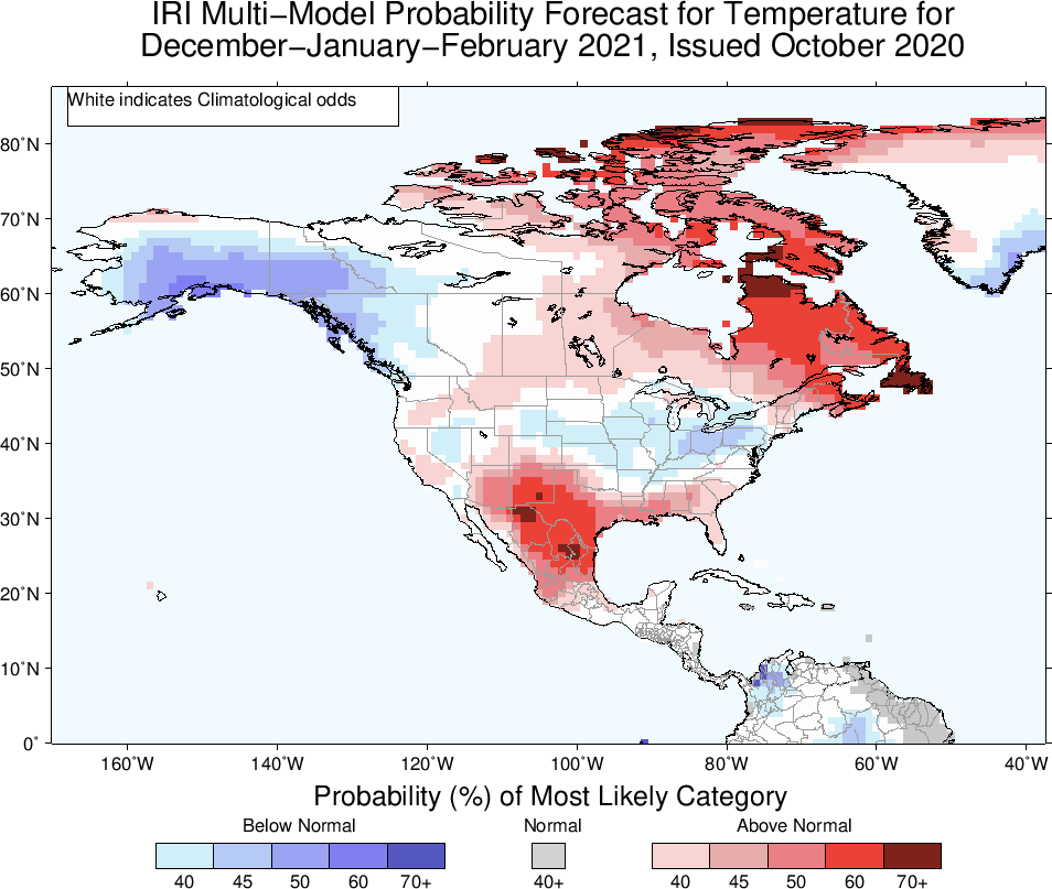
Snow cover in the Northern Hemisphere does not look like anything special now. But given time, and ridging spaced about the North Pole and Arctic Circle, the strong polar westerlies acting in concert with a La Nina signal should produce vigorous storms in the middle latitudes. The dryness in the middle of the continent could limit snow in the Great Plains and Rocky Mountains. But if the analog predictions verify for the winter months, there will be a great deal of snow in the Great Lakes and Appalachia. The best odds on snow impacts along the Interstate 95 corridor appear to be for February and March. The two most active storm track threats: Alberta Clippers and "Miller B" Hatteras Lows (one of which could be a memorable winter storm).
A colder winter, overall, than the five most recent DJFM period
ME:
These SST are very interesting and are going to give forecasters a very trying time this year. We await Isotherms winter dissertation in the coming 2 weeks. Where the HP sets up over the warm blob remains to be seen. That is a cold Southern Pac. Indian Ocean looks to be settled in Central to Eastern region.
.jpg)
Phases
[img] [/img]
found this on another sight...Cosgroves thoughts....
MONTHLY FORECASTS
NOVEMBER
Most of the analog years present a fairly standard +PNA signature with a warm West vs. cool Central, East alignment. But a recurrent issue is that all model guidance is solidly warmer than normal over most of North America. Given that the comparison test looks almost exactly like the same September 1 - October 16 of this year, I kept the temperature forecast very close to the twelve-year mean.
If shortwave injections into the Mid-Continent mean trough are as strong as what is shown now over the northern Pacific Ocean, potential for high wind events will be high from the Rocky Mountains into the Mississippi Valley and Great Lakes in November.
DECEMBER
A more difficult forecast, since there is a prominent warm-up across the Old South and Mid-Atlantic regions which may not be viable. Note the positive height anomaly in the -NAO position (Baffin Island and Greenland) which in many cases could be construed as a block that triggers southward deviation of the jet stream. That said, the numerical model guidance is very aggressive in presenting a Southeast ridge. That feature is normally linked to very warm conditions east of the Rocky Mountains. The gradient set-up between recurrent storms over MT and WY vs. the ridging implies repeated high surface wind potential from the Great Plains and Texas into the Corn Belt.
Caveat: Should the high-latitude anticyclone be the stronger of the two ridges, temperatures will be much colder across the Midwest and Northeast than what is shown here.
JANUARY
A much colder outlook than the previous attempt. The presence of ridging in the -EPO, -AO, and -NAO positions normally favors relocation of the cA vortex at 500MB into Ontario and James Bay. Indeed, with the core negative height anomaly aloft centered roughly over MN and W ON cold pooling will probably relocate to between the Rocky Mountains and Appalachia. The surface storm track may stay inland over the Piedmont and Atlantic Coastal Plain, so the major cities may have cases of rain and not snow. All things considered, there will likely be some very wintry moments in the Midwest and Great Lakes. The western states seem warmer and drier than normal outside of a few frontal passages along the Pacific Coast.
Caveat: It would not take much, with the widespread ridging at higher latitudes, to turn the Eastern Seaboard into a winter wonderland as we start 2021.
FEBRUARY
Similar in many ways to the January upper air pattern, but with more extensive cyclonic curvature and cold air through the eastern two-thirds of the nation. If there is going to be a major snowstorm along the East Coast, it probably will be in February. Note the stability of the blocking ridge complex above the Arctic Circle.
Caveats: If ridging builds into British Columbia, we could see cases of severe cold and more frequent frozen precipitation from the Great Plains to the East Coast. Conversely, if the blocking signature is weaker, there may be some merit in the very warm outlooks posted by the CFS and ECMWF series.
MARCH
Yet another example of a back-ended winter forecast. Note that there is very little change in high-latitude ridge position and strength. In theory, if this forecast verifies, abundant snow in the Great Lakes, Mid-Atlantic, and New England could help to maintain substantial cold to the right of the Continental Divide.
Caveats: The very warm numerical models continue to concern me, and are a reason that I moderated temperatures somewhat from the Mid-Atlantic to the Eastern Seaboard.
Curiously, all analog and modeled guidance suggests a turn to much warmer weather nationally as we enter April. But March should be cold.
SUMMARY
Snow cover in the Northern Hemisphere does not look like anything special now. But given time, and ridging spaced about the North Pole and Arctic Circle, the strong polar westerlies acting in concert with a La Nina signal should produce vigorous storms in the middle latitudes. The dryness in the middle of the continent could limit snow in the Great Plains and Rocky Mountains. But if the analog predictions verify for the winter months, there will be a great deal of snow in the Great Lakes and Appalachia. The best odds on snow impacts along the Interstate 95 corridor appear to be for February and March. The two most active storm track threats: Alberta Clippers and "Miller B" Hatteras Lows (one of which could be a memorable winter storm).
A colder winter, overall, than the five most recent DJFM period
ME:
These SST are very interesting and are going to give forecasters a very trying time this year. We await Isotherms winter dissertation in the coming 2 weeks. Where the HP sets up over the warm blob remains to be seen. That is a cold Southern Pac. Indian Ocean looks to be settled in Central to Eastern region.
.jpg)
Phases
[img]
 [/img]
Last edited by amugs on Sun Nov 01, 2020 8:01 pm; edited 1 time in total
_________________
Mugs
AKA:King: Snow Weenie
Self Proclaimed
WINTER 2014-15 : 55.12" +.02 for 6 coatings (avg. 35")
WINTER 2015-16 Total - 29.8" (Avg 35")
WINTER 2016-17 : 39.5" so far

amugs- Advanced Forecaster - Mod

- Posts : 15157
Reputation : 213
Join date : 2013-01-07
Age : 54
Location : Hillsdale,NJ
 Re: Long Range Discussion 20(20) (Ha!)
HectorO wrote:Dunnzoo wrote:algae888 wrote:A few thoughts as we are heading closer to Winter. Region 3.4 is now at -1.6 which is a moderate la nina and could approach -2 in December which would make it a strong La Nina. The waters off the California coast are extremely warm which is unprecedented with this strong of a la nina so I would be cautious using any analogs for past years. Also I am hearing the mjo could more often than not end up in phases 8 1 and 2 rather than the maritime continent this year do not know the effects of the mjo this winter with such a strong la nina. So far about 90% of winter forecast that I have seen are warm and snowless for our area
Yeah, haven't seen any cold & snowy forecasts for this winter, but the way the squirrels are eating every pumpkin and stealing Halloween candy, they look like they are getting ready to hunker down for a long cold winter!
Really? There were quite a few snowy and cold prediction back in the first week or so of September. Now, it's just the opposite. I really don't get the whole Nino and Nina. On this board I've heard people say we need a La Nina for a good winter and others say El Nino.
Hector I believe this is the second time you asked this question this fall. I don’t believe anyone responded the first time. Every year one of the first drivers that gets focused on is the status of ENSO. The reason it’s talked about Is because it involves one of the largest regions in the largest body of water the planet has to offer. Also every year there are always MANY other factors that either work with or against how the temperature anomalies in the tropical pacific affect the jet streams as they head towards North America which the sum of all the moving parts is what leads to the final outcome. . In years when ENSO status is a main driver one might make an inference as to how winter might play out based on just how strong or weak or neutral the Nino/Nina is. But IMO as we transition the solar cycle from decades of solar maximum to now periods of low solar activity my guess is what we think we know about how things should happen will need to be modified. The sun affects all the players from the troposphere all the way up through the stratosphere as well as the SSTemps in all major oceans. Another decade or so of low solar and we will really see some changes.
Mugs I haven’t been on any of the other sites in some time. Have you seen any info on when Tom(Isotherm) is going to post his LR forecast for winter? In my humble opinion until he speaks no LR forecast has any traction.
_________________
"In weather and in life, there's no winning and losing; there's only winning and learning."
WINTER 2012/2013 TOTALS 43.65"WINTER 2017/2018 TOTALS 62.85" WINTER 2022/2023 TOTALS 4.9"
WINTER 2013/2014 TOTALS 64.85"WINTER 2018/2019 TOTALS 14.25" WINTER 2023/2024 TOTALS 13.1"
WINTER 2014/2015 TOTALS 71.20"WINTER 2019/2020 TOTALS 6.35" WINTER 2024/2025 TOTALS 0.00
WINTER 2015/2016 TOTALS 35.00"WINTER 2020/2021 TOTALS 37.75"
WINTER 2016/2017 TOTALS 42.25"WINTER 2021/2022 TOTALS 31.65"

sroc4- Admin

- Posts : 8459
Reputation : 302
Join date : 2013-01-07
Location : Wading River, LI
HectorO likes this post
 Re: Long Range Discussion 20(20) (Ha!)
Sorry mugs, we can't see any of your images!
_________________
Janet
Snowfall winter of 2023-2024 17.5"
Snowfall winter of 2022-2023 6.0"
Snowfall winter of 2021-2022 17.6" 1" sleet 2/25/22
Snowfall winter of 2020-2021 51.1"
Snowfall winter of 2019-2020 8.5"
Snowfall winter of 2018-2019 25.1"
Snowfall winter of 2017-2018 51.9"
Snowfall winter of 2016-2017 45.6"
Snowfall winter of 2015-2016 29.5"
Snowfall winter of 2014-2015 50.55"
Snowfall winter of 2013-2014 66.5"

Dunnzoo- Senior Enthusiast - Mod

- Posts : 4938
Reputation : 68
Join date : 2013-01-11
Age : 62
Location : Westwood, NJ
 Re: Long Range Discussion 20(20) (Ha!)
SROC,
He said mid November so in about 2 weeks. Going to be very interesting.
Zoo let me try and re upload them and post again.
He said mid November so in about 2 weeks. Going to be very interesting.
Zoo let me try and re upload them and post again.
_________________
Mugs
AKA:King: Snow Weenie
Self Proclaimed
WINTER 2014-15 : 55.12" +.02 for 6 coatings (avg. 35")
WINTER 2015-16 Total - 29.8" (Avg 35")
WINTER 2016-17 : 39.5" so far

amugs- Advanced Forecaster - Mod

- Posts : 15157
Reputation : 213
Join date : 2013-01-07
Age : 54
Location : Hillsdale,NJ
sroc4 likes this post
 Re: Long Range Discussion 20(20) (Ha!)
sroc4 wrote:HectorO wrote:Dunnzoo wrote:algae888 wrote:A few thoughts as we are heading closer to Winter. Region 3.4 is now at -1.6 which is a moderate la nina and could approach -2 in December which would make it a strong La Nina. The waters off the California coast are extremely warm which is unprecedented with this strong of a la nina so I would be cautious using any analogs for past years. Also I am hearing the mjo could more often than not end up in phases 8 1 and 2 rather than the maritime continent this year do not know the effects of the mjo this winter with such a strong la nina. So far about 90% of winter forecast that I have seen are warm and snowless for our area
Yeah, haven't seen any cold & snowy forecasts for this winter, but the way the squirrels are eating every pumpkin and stealing Halloween candy, they look like they are getting ready to hunker down for a long cold winter!
Really? There were quite a few snowy and cold prediction back in the first week or so of September. Now, it's just the opposite. I really don't get the whole Nino and Nina. On this board I've heard people say we need a La Nina for a good winter and others say El Nino.
Hector I believe this is the second time you asked this question this fall. I don’t believe anyone responded the first time. Every year one of the first drivers that gets focused on is the status of ENSO. The reason it’s talked about Is because it involves one of the largest regions in the largest body of water the planet has to offer. Also every year there are always MANY other factors that either work with or against how the temperature anomalies in the tropical pacific affect the jet streams as they head towards North America which the sum of all the moving parts is what leads to the final outcome. . In years when ENSO status is a main driver one might make an inference as to how winter might play out based on just how strong or weak or neutral the Nino/Nina is. But IMO as we transition the solar cycle from decades of solar maximum to now periods of low solar activity my guess is what we think we know about how things should happen will need to be modified. The sun affects all the players from the troposphere all the way up through the stratosphere as well as the SSTemps in all major oceans. Another decade or so of low solar and we will really see some changes.
Mugs I haven’t been on any of the other sites in some time. Have you seen any info on when Tom(Isotherm) is going to post his LR forecast for winter? In my humble opinion until he speaks no LR forecast has any traction.
Thanks! I appreciate it!

HectorO- Pro Enthusiast

- Posts : 977
Reputation : 27
Join date : 2013-01-11
sroc4 likes this post
 Re: Long Range Discussion 20(20) (Ha!)
_________________
Mugs
AKA:King: Snow Weenie
Self Proclaimed
WINTER 2014-15 : 55.12" +.02 for 6 coatings (avg. 35")
WINTER 2015-16 Total - 29.8" (Avg 35")
WINTER 2016-17 : 39.5" so far

amugs- Advanced Forecaster - Mod

- Posts : 15157
Reputation : 213
Join date : 2013-01-07
Age : 54
Location : Hillsdale,NJ
 Re: Long Range Discussion 20(20) (Ha!)
Ripped from one of my posts elsewhere, in response to blocking trying to show up in the extended from several days ago:
“Personally, I would not hang my hat on this, at all. November, much like @donsutherland1’s analogs, is looking pretty warm to me, with any cold intrusions being short lived. The standing wave over and near the Maritime Continent is a back breaker, as it will work to keep the MJO trapped in phases 3-7, which largely result in above-average temperatures for us as we head into our cold season. Unless we see an alteration in the tropics that can shake the standing wave, and/or get a PV shakeup, my hopes for this entire winter are not too high overall (though I can see how could manage a few BIG events amongst the warmth). I’m not too well-versed long-range/seasonal forecasting, admittedly, but I’m being honest based on what I’m seeing now. We may be able to somewhat salvage the last third of Winter if the PV cooperates, which I believe somebody posted about having historical tendency in La Niña/QBO west years beginning in February, but until I see physical signs of that and/or the tropical alteration, I will remain skeptical of any prolonged below-average regime.”
“Personally, I would not hang my hat on this, at all. November, much like @donsutherland1’s analogs, is looking pretty warm to me, with any cold intrusions being short lived. The standing wave over and near the Maritime Continent is a back breaker, as it will work to keep the MJO trapped in phases 3-7, which largely result in above-average temperatures for us as we head into our cold season. Unless we see an alteration in the tropics that can shake the standing wave, and/or get a PV shakeup, my hopes for this entire winter are not too high overall (though I can see how could manage a few BIG events amongst the warmth). I’m not too well-versed long-range/seasonal forecasting, admittedly, but I’m being honest based on what I’m seeing now. We may be able to somewhat salvage the last third of Winter if the PV cooperates, which I believe somebody posted about having historical tendency in La Niña/QBO west years beginning in February, but until I see physical signs of that and/or the tropical alteration, I will remain skeptical of any prolonged below-average regime.”
rb924119- Meteorologist

- Posts : 7116
Reputation : 195
Join date : 2013-02-06
Age : 32
Location : Greentown, Pa
sroc4 likes this post
 Re: Long Range Discussion 20(20) (Ha!)
Wow, almost a full week in November with temps in the 60's??? Years ago, we would get maybe a day or two.This torch bodes ill , not liking it at all.Meanwhile, the Central and North Central states have been getting all the snow.Hope I am wrong, but this looks like a pattern setting up here.

docstox12- Wx Statistician Guru

- Posts : 8617
Reputation : 222
Join date : 2013-01-07
Age : 74
Location : Monroe NY
 Re: Long Range Discussion 20(20) (Ha!)
docstox12 wrote:Wow, almost a full week in November with temps in the 60's??? Years ago, we would get maybe a day or two.This torch bodes ill , not liking it at all.Meanwhile, the Central and North Central states have been getting all the snow.Hope I am wrong, but this looks like a pattern setting up here.
I feel like this has happened before. Back in the 2011/12.... although that was an awful winter.

HectorO- Pro Enthusiast

- Posts : 977
Reputation : 27
Join date : 2013-01-11
 Re: Long Range Discussion 20(20) (Ha!)
Hi all,
Larry Cosgrove will be joining the Joe (Cioffi) and Joe (Rao) show tonight on Youtube at 7:30 pm. Just search for Joe Cioffi's channel. Larry will be talking about his winter outlook, will be interesting for sure!
Larry Cosgrove will be joining the Joe (Cioffi) and Joe (Rao) show tonight on Youtube at 7:30 pm. Just search for Joe Cioffi's channel. Larry will be talking about his winter outlook, will be interesting for sure!
_________________
Janet
Snowfall winter of 2023-2024 17.5"
Snowfall winter of 2022-2023 6.0"
Snowfall winter of 2021-2022 17.6" 1" sleet 2/25/22
Snowfall winter of 2020-2021 51.1"
Snowfall winter of 2019-2020 8.5"
Snowfall winter of 2018-2019 25.1"
Snowfall winter of 2017-2018 51.9"
Snowfall winter of 2016-2017 45.6"
Snowfall winter of 2015-2016 29.5"
Snowfall winter of 2014-2015 50.55"
Snowfall winter of 2013-2014 66.5"

Dunnzoo- Senior Enthusiast - Mod

- Posts : 4938
Reputation : 68
Join date : 2013-01-11
Age : 62
Location : Westwood, NJ
Page 1 of 30 • 1, 2, 3 ... 15 ... 30 
Page 1 of 30
Permissions in this forum:
You cannot reply to topics in this forum
 Home
Home