December 14th Wintry Wave
+18
brownie
Dunnzoo
crippo84
jimv45
docstox12
GreyBeard
algae888
weatherwatchermom
aiannone
CPcantmeasuresnow
Irish
dkodgis
jmanley32
heehaw453
sroc4
billg315
amugs
Frank_Wx
22 posters
Page 1 of 4 • 1, 2, 3, 4 
 December 14th Wintry Wave
It’s officially the start of silly season when two admins of this forum get to create two new storm topics for the same week. Scott took the liberty in starting a topic for Wednesday’s possible BIG storm, but I did not want to overlook the first wave which is forecasted to
hit Monday. This storm is going to act as the 50/50 low for Wednesday’s storm.

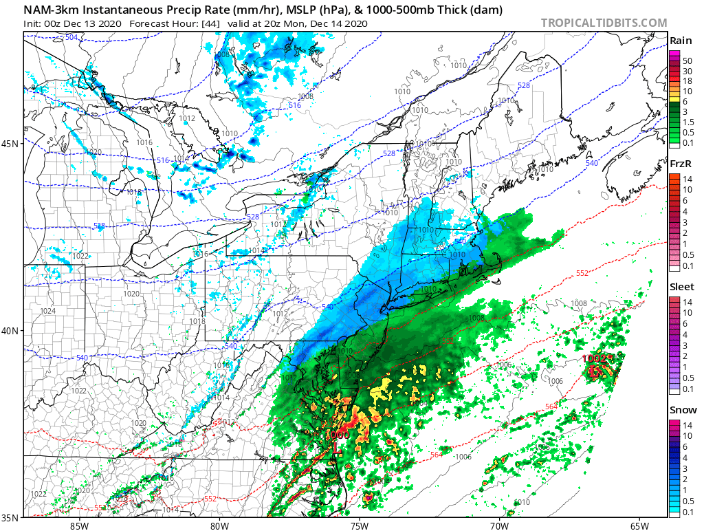
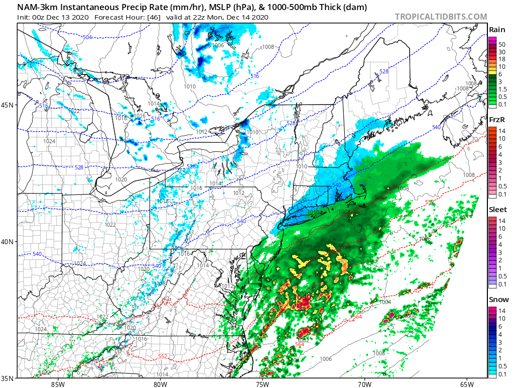
500mb heights ahead of this wave are not favorable for cold temps. As you can see, they are rising over the coast which suggests temps being above freezing. The baroclinic zone, or rain/snow line, is likely running thru I-95 or just N&W of there.

The GFS tries to bring snow all the way down to central NJ and the shore, but it’s important to examine the boundary level temperatures since we’re not currently under a cold air mass. It is a mild weekend, and as shown, heights ahead of the storm are rising. In order to pull the cold air that is to our north down to the coast, we need the storm to intensify and draw those north westerly winds to the coast. A phase is not currently forecasted to occur, therefore keeping this storm on the weaker side and acting more as a “wave” then a big storm.


Nevertheless, the NAM has impressive dynamics that would on paper lead to heavy snowfall falling over portions of this area on Monday. Strong H5 vort energy coupled with a 150Kt jet steak to the north, is a recipe for increased vertical velocity or moderate to heavy snow over areas that will be cold enough.
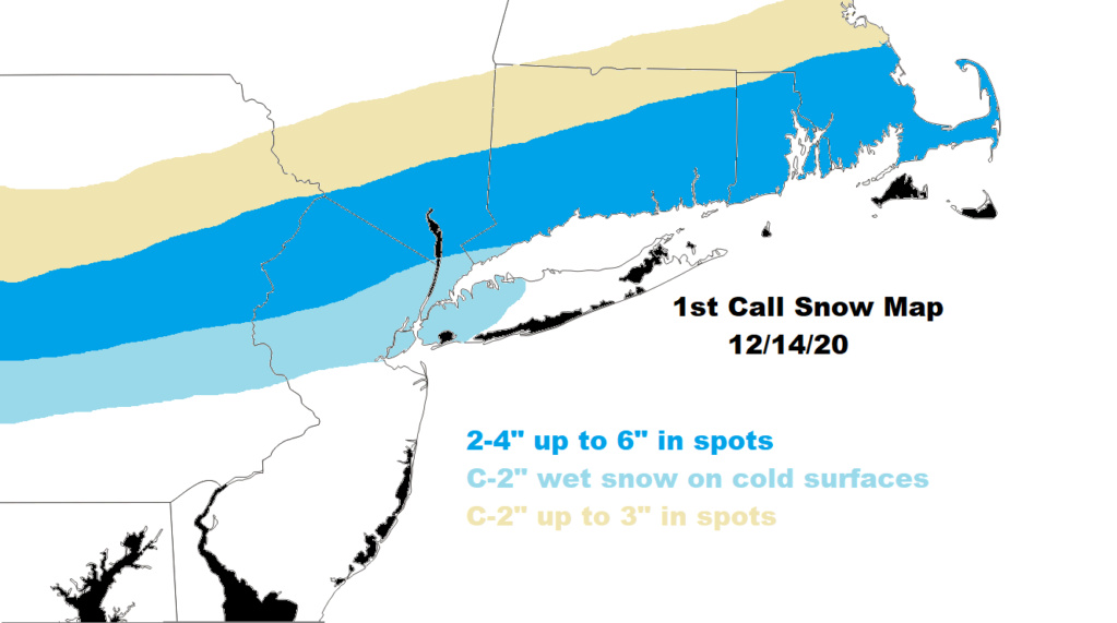
The last few words of that statement are key: over areas that will be cold enough. 700mb-850mb temps look to be cold for nearly the entire area but the shore and eastern parts of Long Island, however, 925mb temps are very warm. This looks to me like 5-10 inches of show might actually fall but only a few inches is what will actually stick type of event. That may not be the case for those N&W of NYC, but the concern there is you may not get enough precip to fall since the storm is taking a track pretty far south.
I will have a snow map out today in the early evening to better show you my thoughts.
hit Monday. This storm is going to act as the 50/50 low for Wednesday’s storm.

500mb heights ahead of this wave are not favorable for cold temps. As you can see, they are rising over the coast which suggests temps being above freezing. The baroclinic zone, or rain/snow line, is likely running thru I-95 or just N&W of there.

The GFS tries to bring snow all the way down to central NJ and the shore, but it’s important to examine the boundary level temperatures since we’re not currently under a cold air mass. It is a mild weekend, and as shown, heights ahead of the storm are rising. In order to pull the cold air that is to our north down to the coast, we need the storm to intensify and draw those north westerly winds to the coast. A phase is not currently forecasted to occur, therefore keeping this storm on the weaker side and acting more as a “wave” then a big storm.


Nevertheless, the NAM has impressive dynamics that would on paper lead to heavy snowfall falling over portions of this area on Monday. Strong H5 vort energy coupled with a 150Kt jet steak to the north, is a recipe for increased vertical velocity or moderate to heavy snow over areas that will be cold enough.
The last few words of that statement are key: over areas that will be cold enough. 700mb-850mb temps look to be cold for nearly the entire area but the shore and eastern parts of Long Island, however, 925mb temps are very warm. This looks to me like 5-10 inches of show might actually fall but only a few inches is what will actually stick type of event. That may not be the case for those N&W of NYC, but the concern there is you may not get enough precip to fall since the storm is taking a track pretty far south.
I will have a snow map out today in the early evening to better show you my thoughts.
Last edited by Frank_Wx on Sat Dec 12, 2020 10:04 pm; edited 1 time in total
_________________
_______________________________________________________________________________________________________
CLICK HERE to view NJ Strong Snowstorm Classifications
 Re: December 14th Wintry Wave
Frank MOMMA MIA my man a Monthrazilla!!
I was seeing a 3" plus but your better at this than me much in this case!!
Those who thought I was crazy when I posted Thursday about this coming N and pattern recognition - now I have the Supreme leaders stamp of approval and ups the ante!!
I was seeing a 3" plus but your better at this than me much in this case!!
Those who thought I was crazy when I posted Thursday about this coming N and pattern recognition - now I have the Supreme leaders stamp of approval and ups the ante!!
_________________
Mugs
AKA:King: Snow Weenie
Self Proclaimed
WINTER 2014-15 : 55.12" +.02 for 6 coatings (avg. 35")
WINTER 2015-16 Total - 29.8" (Avg 35")
WINTER 2016-17 : 39.5" so far

amugs- Advanced Forecaster - Mod

- Posts : 15157
Reputation : 213
Join date : 2013-01-07
Age : 54
Location : Hillsdale,NJ
 Re: December 14th Wintry Wave
I think mothrazilla is a premature call on my part for the city and points south, but I do think a 6 inch snowfall is in the cards for some N&W. It’s a pretty intense piece of upper energy! Let’s see what happens today
_________________
_______________________________________________________________________________________________________
CLICK HERE to view NJ Strong Snowstorm Classifications
 Re: December 14th Wintry Wave
Yes the more this storm gets the better and stronger 50/50 low it makes - for those who do not know what a 50/50 low is:
A low pressure system that parks itself over Newfoundland at 50 degrees both longitude and latitude hence a 50/50 low. This forms a block to the jet stream and the storms the try to come up thus locking them up the coast, slowing them down and causing a CAD signature pf cold air damming out over the Atlantic and into/down the coast.
The stronger this becomes then the more blocking and colder air gets injected into teh coastal plain and slows the whole downstream of weather.
What causes a 50/50 low? Usually a Block over teh North Atlantic region or just a back up of Low Pressure systems too.
Hope this helps!
An Impressive mean for snow on the ENS

_________________
Mugs
AKA:King: Snow Weenie
Self Proclaimed
WINTER 2014-15 : 55.12" +.02 for 6 coatings (avg. 35")
WINTER 2015-16 Total - 29.8" (Avg 35")
WINTER 2016-17 : 39.5" so far

amugs- Advanced Forecaster - Mod

- Posts : 15157
Reputation : 213
Join date : 2013-01-07
Age : 54
Location : Hillsdale,NJ
Grselig likes this post
 Re: December 14th Wintry Wave
We want this storm to be as strong as possible, even if it means we all rain. That’s the sacrifice we need in order to make the mid week storm extremely snowy for all.
_________________
_______________________________________________________________________________________________________
CLICK HERE to view NJ Strong Snowstorm Classifications
 Re: December 14th Wintry Wave
Frank_Wx wrote:We want this storm to be as strong as possible, even if it means we all rain. That’s the sacrifice we need in order to make the mid week storm extremely snowy for all.
I concur Frank but if yuo notice one its passes us it somewhat phases with Northern Jet energy dropping in and bombs out.

969 WOWZA

_________________
Mugs
AKA:King: Snow Weenie
Self Proclaimed
WINTER 2014-15 : 55.12" +.02 for 6 coatings (avg. 35")
WINTER 2015-16 Total - 29.8" (Avg 35")
WINTER 2016-17 : 39.5" so far

amugs- Advanced Forecaster - Mod

- Posts : 15157
Reputation : 213
Join date : 2013-01-07
Age : 54
Location : Hillsdale,NJ
 Re: December 14th Wintry Wave
SOB NAM!!!!!!!!!!!!!!!!!!!!! COME TO POPPA BABY!!!


_________________
Mugs
AKA:King: Snow Weenie
Self Proclaimed
WINTER 2014-15 : 55.12" +.02 for 6 coatings (avg. 35")
WINTER 2015-16 Total - 29.8" (Avg 35")
WINTER 2016-17 : 39.5" so far

amugs- Advanced Forecaster - Mod

- Posts : 15157
Reputation : 213
Join date : 2013-01-07
Age : 54
Location : Hillsdale,NJ
 Re: December 14th Wintry Wave
ITS DEEPR BY ABOUT 6 MB FROM PERVIOUS RUNS = STRONG 50/50 LOW??
_________________
Mugs
AKA:King: Snow Weenie
Self Proclaimed
WINTER 2014-15 : 55.12" +.02 for 6 coatings (avg. 35")
WINTER 2015-16 Total - 29.8" (Avg 35")
WINTER 2016-17 : 39.5" so far

amugs- Advanced Forecaster - Mod

- Posts : 15157
Reputation : 213
Join date : 2013-01-07
Age : 54
Location : Hillsdale,NJ
 Re: December 14th Wintry Wave
I have to say Mugs, you've been on this one and it seems the models are caving to Mugs! lol. I thought this was going to be just some light rain and snow mixed, but I'm now coming around to thinking that in the areas right on that border where the heavy precip cuts off, could see some decent snows out of this. My guess would be the areas where its cold enough to stay snow and stick, will be relatively light in the precipitation intensity category, and most of those with heavier precipitation will be in the "a bit too warm category." But there could be a sweet spot where its just heavy enough to overcome the warmth and give those folks some decent snow with some stickage.
Either way, if this acts as the 50/50 for Wednesday, it will serve its greater purpose in life.
Either way, if this acts as the 50/50 for Wednesday, it will serve its greater purpose in life.

billg315- Advanced Forecaster - Mod

- Posts : 4564
Reputation : 185
Join date : 2015-01-24
Age : 50
Location : Flemington, NJ
 Re: December 14th Wintry Wave
billg315 wrote:I have to say Mugs, you've been on this one and it seems the models are caving to Mugs! lol. I thought this was going to be just some light rain and snow mixed, but I'm now coming around to thinking that in the areas right on that border where the heavy precip cuts off, could see some decent snows out of this. My guess would be the areas where its cold enough to stay snow and stick, will be relatively light in the precipitation intensity category, and most of those with heavier precipitation will be in the "a bit too warm category." But there could be a sweet spot where its just heavy enough to overcome the warmth and give those folks some decent snow with some stickage.
Either way, if this acts as the 50/50 for Wednesday, it will serve its greater purpose in life.
That last line Bill. Love it. Might need to add that the need your signature. Lol
_________________
"In weather and in life, there's no winning and losing; there's only winning and learning."
WINTER 2012/2013 TOTALS 43.65"WINTER 2017/2018 TOTALS 62.85" WINTER 2022/2023 TOTALS 4.9"
WINTER 2013/2014 TOTALS 64.85"WINTER 2018/2019 TOTALS 14.25" WINTER 2023/2024 TOTALS 13.1"
WINTER 2014/2015 TOTALS 71.20"WINTER 2019/2020 TOTALS 6.35" WINTER 2024/2025 TOTALS 0.00
WINTER 2015/2016 TOTALS 35.00"WINTER 2020/2021 TOTALS 37.75"
WINTER 2016/2017 TOTALS 42.25"WINTER 2021/2022 TOTALS 31.65"

sroc4- Admin

- Posts : 8459
Reputation : 302
Join date : 2013-01-07
Location : Wading River, LI
 Re: December 14th Wintry Wave
sroc4 wrote:billg315 wrote:I have to say Mugs, you've been on this one and it seems the models are caving to Mugs! lol. I thought this was going to be just some light rain and snow mixed, but I'm now coming around to thinking that in the areas right on that border where the heavy precip cuts off, could see some decent snows out of this. My guess would be the areas where its cold enough to stay snow and stick, will be relatively light in the precipitation intensity category, and most of those with heavier precipitation will be in the "a bit too warm category." But there could be a sweet spot where its just heavy enough to overcome the warmth and give those folks some decent snow with some stickage.
Either way, if this acts as the 50/50 for Wednesday, it will serve its greater purpose in life.
That last line Bill. Love it. Might need to add that the need your signature. Lol
LOL! I figured someone would appreciate it. Took your advice, it's now my signature (for the time being). lol

billg315- Advanced Forecaster - Mod

- Posts : 4564
Reputation : 185
Join date : 2015-01-24
Age : 50
Location : Flemington, NJ
sroc4 likes this post
 Re: December 14th Wintry Wave
amugs wrote:ITS DEEPR BY ABOUT 6 MB FROM PERVIOUS RUNS = STRONG 50/50 LOW??
GFS is getting very bullish on Monday. BL temps would be only thing holding this back from deep snow.
heehaw453- Advanced Forecaster

- Posts : 3941
Reputation : 86
Join date : 2014-01-20
Location : Bedminster Township, PA Elevation 600' ASL
 Re: December 14th Wintry Wave
heehaw453 wrote:amugs wrote:ITS DEEPR BY ABOUT 6 MB FROM PERVIOUS RUNS = STRONG 50/50 LOW??
GFS is getting very bullish on Monday. BL temps would be only thing holding this back from deep snow.
Yup but I'll take whatever white gold big Momma wants to bring our way.
12Z says gidde up Euro - have to say Euro has been all over this and so many where like say what?? I told our NJWO on Zoom Thursday night that Monday has legs and potential to be a plowable snow fall - they all laughed and said yeah right, many old timers - this from a 50 year old man!

Bell maps

925 Crash on GFS but maybe a bit to warm? The UEO and NAM are this as it starts - we'll see

850's plenty cold

BL crashes with it

Moderate to Heavy snow in teh area at this time which will bring teh BL - surface temp down

Starts as white rain then when darkness settle in we have stick age easily I say.
_________________
Mugs
AKA:King: Snow Weenie
Self Proclaimed
WINTER 2014-15 : 55.12" +.02 for 6 coatings (avg. 35")
WINTER 2015-16 Total - 29.8" (Avg 35")
WINTER 2016-17 : 39.5" so far

amugs- Advanced Forecaster - Mod

- Posts : 15157
Reputation : 213
Join date : 2013-01-07
Age : 54
Location : Hillsdale,NJ
CPcantmeasuresnow likes this post
 Re: December 14th Wintry Wave
Looks good, even potentially for the coast, from what I am reading us at the coast can't take the snow map verbatim, if I do I am around 4-5 which is awesome, when mugs you said or someone said 3 inches I was happy to hear that. Just catching up onto the wed thread cannot wait to read that : )

jmanley32- Senior Enthusiast

- Posts : 20648
Reputation : 108
Join date : 2013-12-12
Age : 43
Location : Yonkers, NY
 Re: December 14th Wintry Wave
I am looking forward to the snow and Mugs...you are 50? I could be your dad


dkodgis- Senior Enthusiast

- Posts : 2694
Reputation : 98
Join date : 2013-12-29
 Re: December 14th Wintry Wave
So, in looking at weather.com and it shows me a all rain for Monday. I'm in central Jersey, southern Middlesex county. Is that basically where the snow/ rain cutoff is?

Irish- Pro Enthusiast

- Posts : 788
Reputation : 19
Join date : 2019-01-16
Age : 46
Location : Old Bridge, NJ
 Re: December 14th Wintry Wave
Irish wrote:So, in looking at weather.com and it shows me a all rain for Monday. I'm in central Jersey, southern Middlesex county. Is that basically where the snow/ rain cutoff is?
Yes right around The Driscoll Bridge
_________________
Mugs
AKA:King: Snow Weenie
Self Proclaimed
WINTER 2014-15 : 55.12" +.02 for 6 coatings (avg. 35")
WINTER 2015-16 Total - 29.8" (Avg 35")
WINTER 2016-17 : 39.5" so far

amugs- Advanced Forecaster - Mod

- Posts : 15157
Reputation : 213
Join date : 2013-01-07
Age : 54
Location : Hillsdale,NJ
 Re: December 14th Wintry Wave
amugs wrote:Irish wrote:So, in looking at weather.com and it shows me a all rain for Monday. I'm in central Jersey, southern Middlesex county. Is that basically where the snow/ rain cutoff is?
Yes right around The Driscoll Bridge
Thx mugs, if the storm setup is helpful for Wednesdays' I'll take it.

Irish- Pro Enthusiast

- Posts : 788
Reputation : 19
Join date : 2019-01-16
Age : 46
Location : Old Bridge, NJ
 Re: December 14th Wintry Wave
dkodgis wrote:I am looking forward to the snow and Mugs...you are 50? I could be your dad

Yeah Damian, that's a bit of a stretch isn't it?

CPcantmeasuresnow- Wx Statistician Guru

- Posts : 7288
Reputation : 230
Join date : 2013-01-07
Age : 103
Location : Eastern Orange County, NY
 Re: December 14th Wintry Wave
Ha ha, yeah. It is 

dkodgis- Senior Enthusiast

- Posts : 2694
Reputation : 98
Join date : 2013-12-29

aiannone- Senior Enthusiast - Mod

- Posts : 4828
Reputation : 92
Join date : 2013-01-07
Location : Saint James, LI (Northwest Suffolk Co.)
 Re: December 14th Wintry Wave
_________________
_______________________________________________________________________________________________________
CLICK HERE to view NJ Strong Snowstorm Classifications
CPcantmeasuresnow likes this post
 Re: December 14th Wintry Wave
Thanks Frank - I'll take this and run!!!
_________________
Mugs
AKA:King: Snow Weenie
Self Proclaimed
WINTER 2014-15 : 55.12" +.02 for 6 coatings (avg. 35")
WINTER 2015-16 Total - 29.8" (Avg 35")
WINTER 2016-17 : 39.5" so far

amugs- Advanced Forecaster - Mod

- Posts : 15157
Reputation : 213
Join date : 2013-01-07
Age : 54
Location : Hillsdale,NJ
heehaw453- Advanced Forecaster

- Posts : 3941
Reputation : 86
Join date : 2014-01-20
Location : Bedminster Township, PA Elevation 600' ASL
 Re: December 14th Wintry Wave
amugs wrote:Thanks Frank - I'll take this and run!!!
Enjoy! I will have my snowflake projectors on!

weatherwatchermom- Senior Enthusiast

- Posts : 3895
Reputation : 78
Join date : 2014-11-25
Location : Hazlet Township, NJ
Page 1 of 4 • 1, 2, 3, 4 
Permissions in this forum:
You cannot reply to topics in this forum
 Home
Home