February 2022 Obs & Discussions
+30
SoulSingMG
dsix85
rb924119
hyde345
jmanley32
frank 638
RJB8525
essexcountypete
mmanisca
Coachgriff
Snow88
Grselig
CPcantmeasuresnow
brownie
Vinnydula
dkodgis
sroc4
SENJsnowman
TheAresian
nutleyblizzard
Frank_Wx
heehaw453
phil155
weatherwatchermom
Radz
docstox12
Dunnzoo
aiannone
billg315
amugs
34 posters
Page 2 of 12
Page 2 of 12 •  1, 2, 3, ... 10, 11, 12
 Re: February 2022 Obs & Discussions
TheAresian wrote:I'm at 17 measurable inches for the winter. The total with the number of snows that didn't cover the ground is maybe 19 or so. Seasonal average is supposed to be either 35 or 37 depending on which site I check. It's gonna take quite a few nickels and dimes to reach that.
Aresian I'm a bit surprised that your specific area averages < 40" per year, no actually shocked. BGM NWS average is 82"/year and elevation in that area is > 1000' ASL on average. I realize BGM sometimes gets enhanced snow from the Lakes, but I would think your area is at least 70" even being 70 miles west.
heehaw453- Advanced Forecaster

- Posts : 3938
Join date : 2014-01-20
 Re: February 2022 Obs & Discussions
heehaw453 wrote:TheAresian wrote:I'm at 17 measurable inches for the winter. The total with the number of snows that didn't cover the ground is maybe 19 or so. Seasonal average is supposed to be either 35 or 37 depending on which site I check. It's gonna take quite a few nickels and dimes to reach that.
Aresian I'm a bit surprised that your specific area averages < 40" per year, no actually shocked. BGM NWS average is 82"/year and elevation in that area is > 1000' ASL on average. I realize BGM sometimes gets enhanced snow from the Lakes, but I would think your area is at least 70" even being 70 miles west.
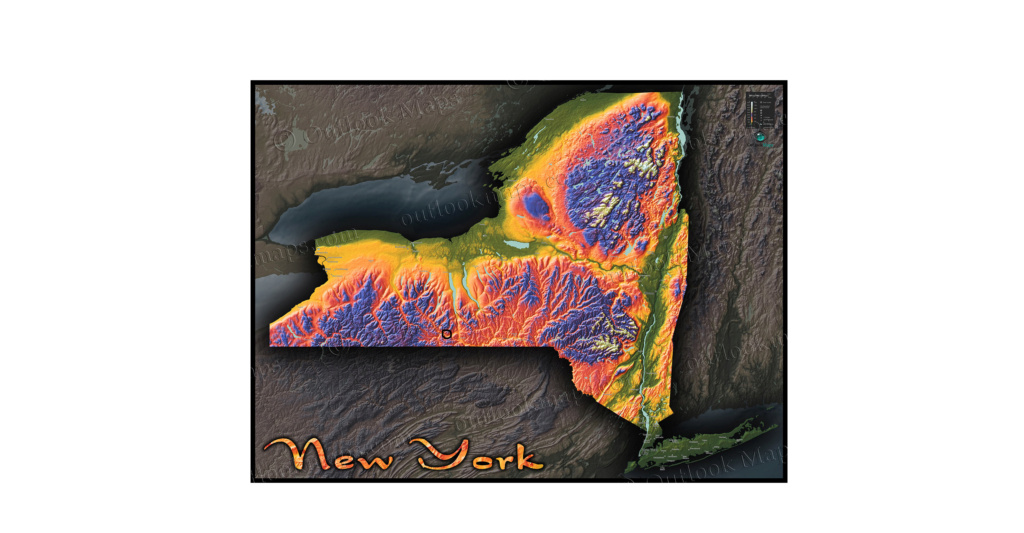
If the map violates some kind of rule let me know and I'll remove it. Either way, I live in the black circle. You can see I have some peculiar geography to deal with. I live in a sort of valley about 900' ASL on the Allegheny plateau. Systems coming from the west transfer off the coast. Systems that do well for you are too far east for me. Mountains to the north and northwest block enhancement from the Great Lakes. It takes an unusual storm track for me to jackpot. Either that or a storm like '93 where a good chunk of the eastern US was buried.
TheAresian- Senior Enthusiast

- Posts : 145
Join date : 2019-11-13
 Re: February 2022 Obs & Discussions
TheAresian wrote:heehaw453 wrote:TheAresian wrote:I'm at 17 measurable inches for the winter. The total with the number of snows that didn't cover the ground is maybe 19 or so. Seasonal average is supposed to be either 35 or 37 depending on which site I check. It's gonna take quite a few nickels and dimes to reach that.
Aresian I'm a bit surprised that your specific area averages < 40" per year, no actually shocked. BGM NWS average is 82"/year and elevation in that area is > 1000' ASL on average. I realize BGM sometimes gets enhanced snow from the Lakes, but I would think your area is at least 70" even being 70 miles west.
If the map violates some kind of rule let me know and I'll remove it. Either way, I live in the black circle. You can see I have some peculiar geography to deal with. I live in a sort of valley about 900' ASL on the Allegheny plateau. Systems coming from the west transfer off the coast. Systems that do well for you are too far east for me. Mountains to the north and northwest block enhancement from the Great Lakes. It takes an unusual storm track for me to jackpot. Either that or a storm like '93 where a good chunk of the eastern US was buried.
Oh wow so you are out there on teh frontier my man!! I have gone to Cayuga Lake a couple of times but you are past that brother.
_________________
Mugs
AKA:King: Snow Weenie
Self Proclaimed
WINTER 2014-15 : 55.12" +.02 for 6 coatings (avg. 35")
WINTER 2015-16 Total - 29.8" (Avg 35")
WINTER 2016-17 : 39.5" so far

amugs- Advanced Forecaster - Mod

- Posts : 15156
Reputation : 213
Join date : 2013-01-07
Age : 54
Location : Hillsdale,NJ
 Re: February 2022 Obs & Discussions
On the storm thread, sroc told me that I'm 250 miles from him as the crow flies. I'm about 22 miles SSW of the southern tip of Seneca Lake, the largest of the Finger Lakes. (Cayuga is longer, but Seneca is wider and deeper)
I had typed out a bunch more stuff but then deleted it because it ended up sounding like a tourism ad.
I had typed out a bunch more stuff but then deleted it because it ended up sounding like a tourism ad.
TheAresian- Senior Enthusiast

- Posts : 145
Reputation : 10
Join date : 2019-11-13
Location : Painted Post, NY
heehaw453- Advanced Forecaster

- Posts : 3938
Reputation : 86
Join date : 2014-01-20
Location : Bedminster Township, PA Elevation 600' ASL
 Re: February 2022 Obs & Discussions
I have been saying that since the first snowstorm in January, everything big going S and E of the HV NY.Let's see how the next 8 weeks, possible snow event time up here, plays out.My gut tells me this S and E pattern will play out the entire winter.
As the old Brooklyn Dodgers used to say....."wait until next year!",LOL.
PS..I hope I am all wrong,LOL.

docstox12- Wx Statistician Guru

- Posts : 8617
Reputation : 222
Join date : 2013-01-07
Age : 74
Location : Monroe NY
heehaw453 likes this post
 Re: February 2022 Obs & Discussions
26 degrees, precip went spotty a few hours ago and had turned to sleet, so even though we had some freezing rain, it was not the disaster it could have been with power outages in the 20's..Radar looks like just some spotty areas but the bulk is over.
Roads salted and clear here.
Just read a report most of Boston's 23.8 inches has melted away due to mild temps and heavy rains.( CP breaks into his happy dance,LOL).
Roads salted and clear here.
Just read a report most of Boston's 23.8 inches has melted away due to mild temps and heavy rains.( CP breaks into his happy dance,LOL).

docstox12- Wx Statistician Guru

- Posts : 8617
Reputation : 222
Join date : 2013-01-07
Age : 74
Location : Monroe NY
CPcantmeasuresnow likes this post
 Re: February 2022 Obs & Discussions
docstox12 wrote:
I have been saying that since the first snowstorm in January, everything big going S and E of the HV NY.Let's see how the next 8 weeks, possible snow event time up here, plays out.My gut tells me this S and E pattern will play out the entire winter.
As the old Brooklyn Dodgers used to say....."wait until next year!",LOL.
PS..I hope I am all wrong,LOL.
Doc, for the past 2-3 yrs you have been spotting and riding the storm track pattern to perfection. I'm thinking I started tuning in to it during that big bust winter 3 yrs ago, when the real pattern was that the future/imminent pattern flip never happened. By the time I caught on to that, it was like mid-Feb already and winter was just dead in the water. But looking back on it, after the 2nd delay in the 'pattern flip', our real pattern had been established.
I still think a switch to a more inland track is inevitable, but obviously, I hope Doc's gut is right for this year. After the last three winters (totals imby I wanna say were 5", 6", and 16"), I have ZERO interest in a futures market for Jersey Shore snow...lol
SENJsnowman- Senior Enthusiast

- Posts : 1201
Reputation : 61
Join date : 2017-01-06
Age : 51
Location : Long Branch, NJ
 Re: February 2022 Obs & Discussions
SENJsnowman wrote:docstox12 wrote:
I have been saying that since the first snowstorm in January, everything big going S and E of the HV NY.Let's see how the next 8 weeks, possible snow event time up here, plays out.My gut tells me this S and E pattern will play out the entire winter.
As the old Brooklyn Dodgers used to say....."wait until next year!",LOL.
PS..I hope I am all wrong,LOL.
Doc, for the past 2-3 yrs you have been spotting and riding the storm track pattern to perfection. I'm thinking I started tuning in to it during that big bust winter 3 yrs ago, when the real pattern was that the future/imminent pattern flip never happened. By the time I caught on to that, it was like mid-Feb already and winter was just dead in the water. But looking back on it, after the 2nd delay in the 'pattern flip', our real pattern had been established.
I still think a switch to a more inland track is inevitable, but obviously, I hope Doc's gut is right for this year. After the last three winters (totals imby I wanna say were 5", 6", and 16"), I have ZERO interest in a futures market for Jersey Shore snow...lol
There will be more chances from 2/10-2/20 as the cold will be established. I wouldn't be at all surprised if there is at least one more sig event down there before you close the curtains. AC snowfall record of 60" in a given season though I believe is safe.
heehaw453- Advanced Forecaster

- Posts : 3938
Reputation : 86
Join date : 2014-01-20
Location : Bedminster Township, PA Elevation 600' ASL
 Re: February 2022 Obs & Discussions
SENJsnowman wrote:docstox12 wrote:
I have been saying that since the first snowstorm in January, everything big going S and E of the HV NY.Let's see how the next 8 weeks, possible snow event time up here, plays out.My gut tells me this S and E pattern will play out the entire winter.
As the old Brooklyn Dodgers used to say....."wait until next year!",LOL.
PS..I hope I am all wrong,LOL.
Doc, for the past 2-3 yrs you have been spotting and riding the storm track pattern to perfection. I'm thinking I started tuning in to it during that big bust winter 3 yrs ago, when the real pattern was that the future/imminent pattern flip never happened. By the time I caught on to that, it was like mid-Feb already and winter was just dead in the water. But looking back on it, after the 2nd delay in the 'pattern flip', our real pattern had been established.
I still think a switch to a more inland track is inevitable, but obviously, I hope Doc's gut is right for this year. After the last three winters (totals imby I wanna say were 5", 6", and 16"), I have ZERO interest in a futures market for Jersey Shore snow...lol
SE, I have been watching winters in the tri state since 1960-1961, purely observations, but patterns do repeat.That's how I make my living as a trader/investor by following "the trend is your friend!"....until it isn't, but it will give you clues.
You were due for a kick arse mean reversion and now you are collecting on it.So glad for that because your enthusiasm and loyalty to the board is outstanding. Heehaw is right, don't put away the snow shovel yet, until we north crew gets a big one, your still in play.

docstox12- Wx Statistician Guru

- Posts : 8617
Reputation : 222
Join date : 2013-01-07
Age : 74
Location : Monroe NY
heehaw453- Advanced Forecaster

- Posts : 3938
Reputation : 86
Join date : 2014-01-20
Location : Bedminster Township, PA Elevation 600' ASL
 Re: February 2022 Obs & Discussions
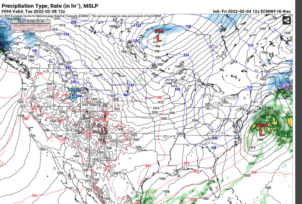
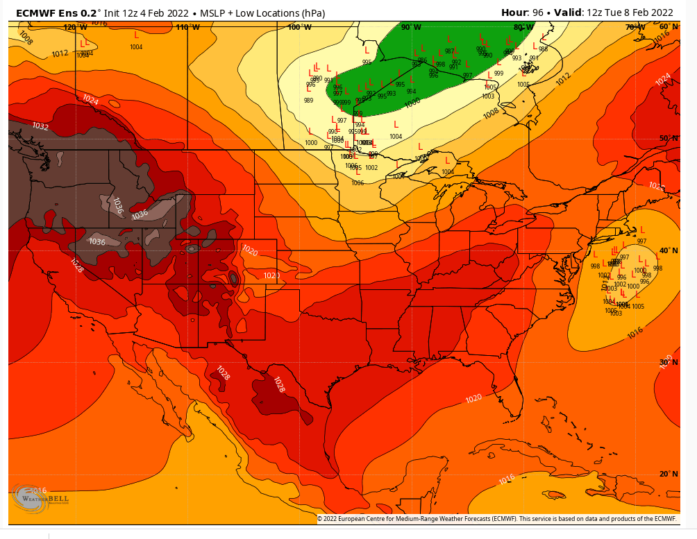
Regarding 2/8 Canadian GEPS is showing similar to ^^^ Euro EPS FWIW.
heehaw453- Advanced Forecaster

- Posts : 3938
Reputation : 86
Join date : 2014-01-20
Location : Bedminster Township, PA Elevation 600' ASL
heehaw453- Advanced Forecaster

- Posts : 3938
Reputation : 86
Join date : 2014-01-20
Location : Bedminster Township, PA Elevation 600' ASL
 Re: February 2022 Obs & Discussions
docstox12 wrote:SENJsnowman wrote:docstox12 wrote:
I have been saying that since the first snowstorm in January, everything big going S and E of the HV NY.Let's see how the next 8 weeks, possible snow event time up here, plays out.My gut tells me this S and E pattern will play out the entire winter.
As the old Brooklyn Dodgers used to say....."wait until next year!",LOL.
PS..I hope I am all wrong,LOL.
Doc, for the past 2-3 yrs you have been spotting and riding the storm track pattern to perfection. I'm thinking I started tuning in to it during that big bust winter 3 yrs ago, when the real pattern was that the future/imminent pattern flip never happened. By the time I caught on to that, it was like mid-Feb already and winter was just dead in the water. But looking back on it, after the 2nd delay in the 'pattern flip', our real pattern had been established.
I still think a switch to a more inland track is inevitable, but obviously, I hope Doc's gut is right for this year. After the last three winters (totals imby I wanna say were 5", 6", and 16"), I have ZERO interest in a futures market for Jersey Shore snow...lol
SE, I have been watching winters in the tri state since 1960-1961, purely observations, but patterns do repeat.That's how I make my living as a trader/investor by following "the trend is your friend!"....until it isn't, but it will give you clues.
You were due for a kick arse mean reversion and now you are collecting on it. So glad for that because your enthusiasm and loyalty to the board is outstanding. Heehaw is right, don't put away the snow shovel yet, until we north crew gets a big one, your still in play.
Thanks so much for the kind words. I don't know much about how this weather stuff works, so all I really have to offer is some optimistic energy and corny stories! lol. These mets on here are not only superb weather folk, but they also give lessons daily on structured disciplined thinking and mature problem solving. Those qualities are especially refreshing to see since they are now freakishly scarce in society today. Add to that the deep and practical wisdom that seems to emanate from the whole LHV crew and the board makes the enthusiasm hard for me to resist.
And notice what else heehaw said about the maybe threat for next week. The exact same thing he's being saying all month (bless his heart for it too!): The coast has a shot...so the trend is still in firmly in place as of now...
And the 'trend is your friend...until it isn't'. I'm guessing, that's the rub in the trading world, right? Getting out before the 'until it isn't' comes to pass. You seem to have a very keenly trained eye for the early off-ramps.
SENJsnowman- Senior Enthusiast

- Posts : 1201
Reputation : 61
Join date : 2017-01-06
Age : 51
Location : Long Branch, NJ
 Re: February 2022 Obs & Discussions
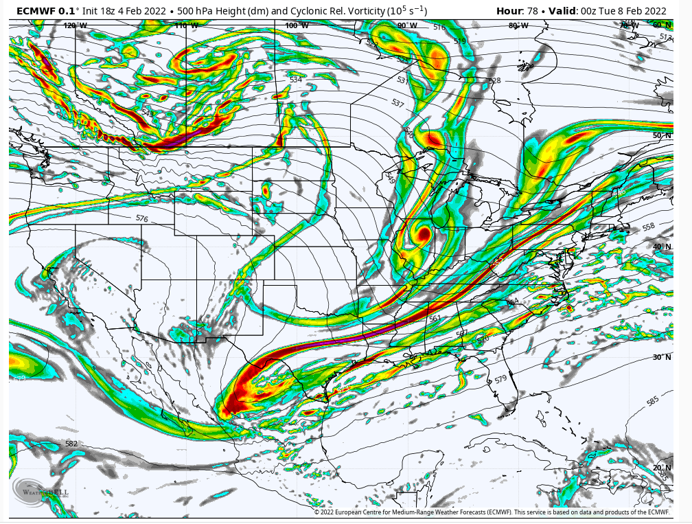
A storm be brewin' for 2/8 for eastern coastal folks. As is usual practice this winter interior areas could be fringed.
Couple of issues
1/ boundary layers are marginal at the surface/low levels
2/ does it get close enough which will be based on phasing
If this can deepen more quickly it'll be able to offset that boundary layer issues especially in E LI. Basically, if this n/s energy drops into the backside of the trough a few hours more quickly, then I think this could be a decent storm as you have a subtropical feed. That means this will be moist. Probably won't work out but it's interesting...

heehaw453- Advanced Forecaster

- Posts : 3938
Reputation : 86
Join date : 2014-01-20
Location : Bedminster Township, PA Elevation 600' ASL
 Re: February 2022 Obs & Discussions
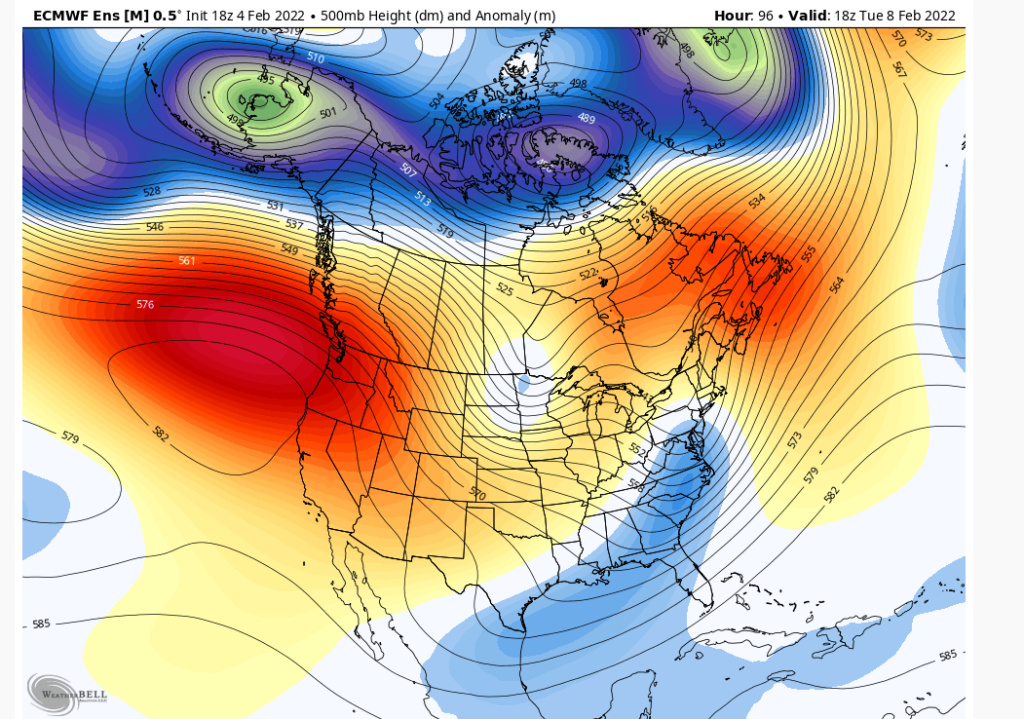
Don't think issue will be with EC heights. Note the pull of the through on this as it's sandwiched between two ridges. Like I mentioned many times with progressive patterns (no high latitude blocking) all this stuff has minimal time to develop for our latitude. It's got to be money right from the get go, otherwise it matures too late and becomes a GOM (Gulf of Maine) special. It's one of the main reason why I think interior folks will struggle to get anything but nickel and dime.

heehaw453- Advanced Forecaster

- Posts : 3938
Reputation : 86
Join date : 2014-01-20
Location : Bedminster Township, PA Elevation 600' ASL
 Re: February 2022 Obs & Discussions
heehaw453 wrote:A storm be brewin' for 2/8 for eastern coastal folks. As is usual practice this winter interior areas could be fringed.
Couple of issues
1/ boundary layers are marginal at the surface/low levels
2/ does it get close enough which will be based on phasing
If this can deepen more quickly it'll be able to offset that boundary layer issues especially in E LI. Basically, if this n/s energy drops into the backside of the trough a few hours more quickly, then I think this could be a decent storm as you have a subtropical feed. That means this will be moist. Probably won't work out but it's interesting...
In general the track as been trending fairly favorable for myself and my Suffolk county and coastal crew, (on or just outside the bench mark), to sneak in some QPF here, but looks like not only boundary/surface layers marginal, but mid levels look like garbage as well. There is a southerly surge of air out of the deep southeast Atlantic at 925-850 as the Low forms off the Carolina coast line. Like you said the timing of the n/s just isnt there. Im becoming more optimistic at perhaps seeing 0.3-0.5"(+/-) of QPF but I am not optimistic it will fall in the form of snow. Ill give it another day or two because the antecedent air mass is pretty cold, but this as a snow threat is waning fast for me. I need to see that low trend stronger to drag in the cold air quicker into the mid levels.
_________________
"In weather and in life, there's no winning and losing; there's only winning and learning."
WINTER 2012/2013 TOTALS 43.65"WINTER 2017/2018 TOTALS 62.85" WINTER 2022/2023 TOTALS 4.9"
WINTER 2013/2014 TOTALS 64.85"WINTER 2018/2019 TOTALS 14.25" WINTER 2023/2024 TOTALS 13.1"
WINTER 2014/2015 TOTALS 71.20"WINTER 2019/2020 TOTALS 6.35" WINTER 2024/2025 TOTALS 0.00
WINTER 2015/2016 TOTALS 35.00"WINTER 2020/2021 TOTALS 37.75"
WINTER 2016/2017 TOTALS 42.25"WINTER 2021/2022 TOTALS 31.65"

sroc4- Admin

- Posts : 8458
Reputation : 302
Join date : 2013-01-07
Location : Wading River, LI
 Re: February 2022 Obs & Discussions
Watch out today y’all. That black ice looks bad by me, And I imagine it’s worse the more north you go.
SENJsnowman- Senior Enthusiast

- Posts : 1201
Reputation : 61
Join date : 2017-01-06
Age : 51
Location : Long Branch, NJ
weatherwatchermom likes this post
 Re: February 2022 Obs & Discussions
sroc4 wrote:heehaw453 wrote:A storm be brewin' for 2/8 for eastern coastal folks. As is usual practice this winter interior areas could be fringed.
Couple of issues
1/ boundary layers are marginal at the surface/low levels
2/ does it get close enough which will be based on phasing
If this can deepen more quickly it'll be able to offset that boundary layer issues especially in E LI. Basically, if this n/s energy drops into the backside of the trough a few hours more quickly, then I think this could be a decent storm as you have a subtropical feed. That means this will be moist. Probably won't work out but it's interesting...
In general the track as been trending fairly favorable for myself and my Suffolk county and coastal crew, (on or just outside the bench mark), to sneak in some QPF here, but looks like not only boundary/surface layers marginal, but mid levels look like garbage as well. There is a southerly surge of air out of the deep southeast Atlantic at 925-850 as the Low forms off the Carolina coast line. Like you said the timing of the n/s just isnt there. Im becoming more optimistic at perhaps seeing 0.3-0.5"(+/-) of QPF but I am not optimistic it will fall in the form of snow. Ill give it another day or two because the antecedent air mass is pretty cold, but this as a snow threat is waning fast for me. I need to see that low trend stronger to drag in the cold air quicker into the mid levels.
Yeah I'd say a no go on this one. I think due to progressive pattern coupled with marginal air mass makes this very untenable. If a good antecedent air mass was in place then you'd have potential for several inches IMO.
heehaw453- Advanced Forecaster

- Posts : 3938
Reputation : 86
Join date : 2014-01-20
Location : Bedminster Township, PA Elevation 600' ASL
 Re: February 2022 Obs & Discussions
Antecedent air mass should have been much better. Less than 24 hrs out all levels are plenty cold. But the cold air gets kicked out like a crumb being flicked off the kitchen table. It is what it is.
_________________
"In weather and in life, there's no winning and losing; there's only winning and learning."
WINTER 2012/2013 TOTALS 43.65"WINTER 2017/2018 TOTALS 62.85" WINTER 2022/2023 TOTALS 4.9"
WINTER 2013/2014 TOTALS 64.85"WINTER 2018/2019 TOTALS 14.25" WINTER 2023/2024 TOTALS 13.1"
WINTER 2014/2015 TOTALS 71.20"WINTER 2019/2020 TOTALS 6.35" WINTER 2024/2025 TOTALS 0.00
WINTER 2015/2016 TOTALS 35.00"WINTER 2020/2021 TOTALS 37.75"
WINTER 2016/2017 TOTALS 42.25"WINTER 2021/2022 TOTALS 31.65"

sroc4- Admin

- Posts : 8458
Reputation : 302
Join date : 2013-01-07
Location : Wading River, LI
weatherwatchermom likes this post
 Re: February 2022 Obs & Discussions
low of 22 this morning..currently 27 with winds out of the nw @18 we had a couple of gusts almost 30..can see the whitecaps in the bay this morning.

weatherwatchermom- Senior Enthusiast

- Posts : 3895
Reputation : 78
Join date : 2014-11-25
Location : Hazlet Township, NJ
 Re: February 2022 Obs & Discussions
2/8 system cannot rule out a c-1" for NW of 95. Will be fringed most likely as this develops too late, but good enough boundary layer may provide a path to some snow. A slightly earlier n/s drop in to the backside of the trough brings this closer and more of a threat.
heehaw453- Advanced Forecaster

- Posts : 3938
Reputation : 86
Join date : 2014-01-20
Location : Bedminster Township, PA Elevation 600' ASL
 Re: February 2022 Obs & Discussions
3 degrees waking up. Still ice-coated trees. If I ever figure out how to post a few pictures, I will put those in the 4th thread before it gets locked. It’s 12 degrees warmer in Buffalo right now.

dkodgis- Senior Enthusiast

- Posts : 2693
Reputation : 98
Join date : 2013-12-29
 Re: February 2022 Obs & Discussions
6 degrees ,clear calm wind and 6 inches of concrete on the ground.Same here, Damian, trees ice covered as well.Maybe a little snow early this week but temps getting to around 40 as the week progresses.Think this will be a below average snow year here, lack of southern energy to phase and progressive pattern are the causes.

docstox12- Wx Statistician Guru

- Posts : 8617
Reputation : 222
Join date : 2013-01-07
Age : 74
Location : Monroe NY
 Re: February 2022 Obs & Discussions
Hit 9 degrees with snowfall only in piles. Good radiational cooling.
heehaw453- Advanced Forecaster

- Posts : 3938
Reputation : 86
Join date : 2014-01-20
Location : Bedminster Township, PA Elevation 600' ASL
 Re: February 2022 Obs & Discussions
It’s cold as heck out
Wish we had something to track. Still thinking there’s a SB/Val storm lurking…
Wish we had something to track. Still thinking there’s a SB/Val storm lurking…
_________________
_______________________________________________________________________________________________________
CLICK HERE to view NJ Strong Snowstorm Classifications
amugs likes this post
 Re: February 2022 Obs & Discussions
_________________
Mugs
AKA:King: Snow Weenie
Self Proclaimed
WINTER 2014-15 : 55.12" +.02 for 6 coatings (avg. 35")
WINTER 2015-16 Total - 29.8" (Avg 35")
WINTER 2016-17 : 39.5" so far

amugs- Advanced Forecaster - Mod

- Posts : 15156
Reputation : 213
Join date : 2013-01-07
Age : 54
Location : Hillsdale,NJ
Page 2 of 12 •  1, 2, 3, ... 10, 11, 12
Page 2 of 12
Permissions in this forum:
You cannot reply to topics in this forum
 Home
Home