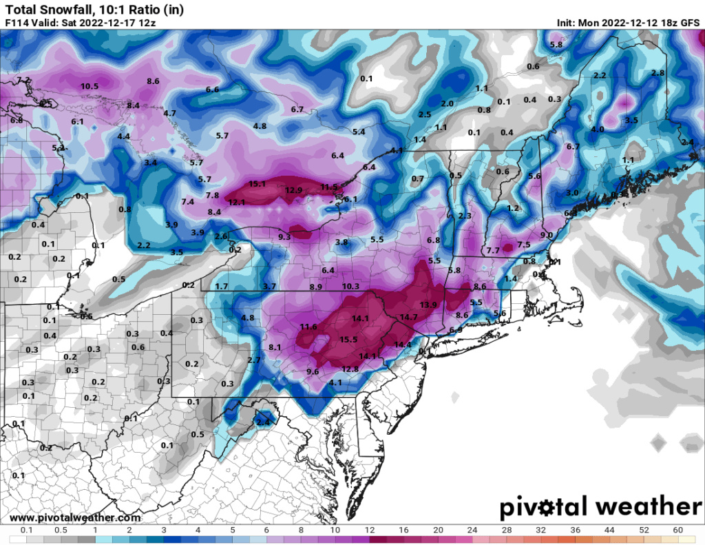
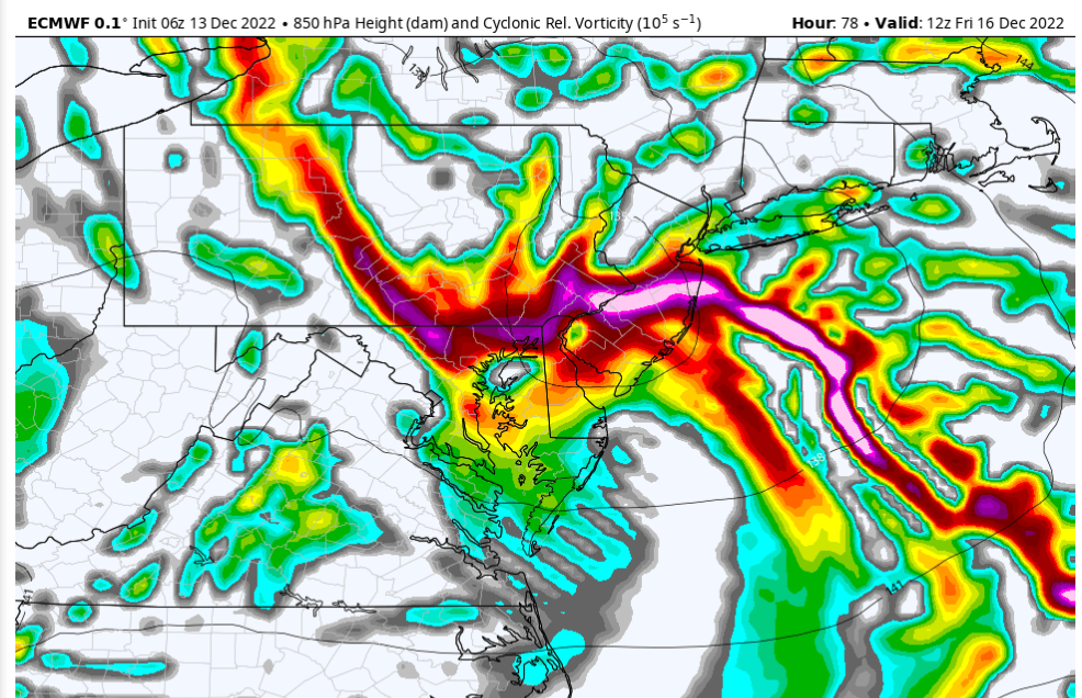
Dec 16 Just a little change can make the difference
Page 2 of 8 •  1, 2, 3, 4, 5, 6, 7, 8
jmanley32- Senior Enthusiast

- Posts : 20646
Join date : 2013-12-12
heehaw453- Advanced Forecaster

- Posts : 3939
Join date : 2014-01-20
 Re: Dec 16 Just a little change can make the difference
_________________
Mugs
AKA:King: Snow Weenie
Self Proclaimed
WINTER 2014-15 : 55.12" +.02 for 6 coatings (avg. 35")
WINTER 2015-16 Total - 29.8" (Avg 35")
WINTER 2016-17 : 39.5" so far

amugs- Advanced Forecaster - Mod

- Posts : 15156
Reputation : 213
Join date : 2013-01-07
Age : 54
Location : Hillsdale,NJ
heehaw453- Advanced Forecaster

- Posts : 3939
Reputation : 86
Join date : 2014-01-20
Location : Bedminster Township, PA Elevation 600' ASL
 Re: Dec 16 Just a little change can make the difference
amugs wrote:CMC and EPS are noticeably SE and colder. Again, DON'T DOUBT CAD NOR THE BLOCK.
I do not doubt it, but I do think these features will protect N&W more so than help S&E. In my mind N&W is a lock for snow, and likely significant at that. Certainly a storm that will warrant its first snow map of the season!
For S&E I need to see more. MORE MUGS MORE
_________________
_______________________________________________________________________________________________________
CLICK HERE to view NJ Strong Snowstorm Classifications
sroc4, SENJsnowman and MattyICE like this post
 Re: Dec 16 Just a little change can make the difference
The immediate coast is going be tough. If this thing bombs a bit though and stalls off the coast it would crash the mid-levels. The 50/50 is there to block things up and the ULL the storm comes from is pretty vigorous. Never know...Frank_Wx wrote:amugs wrote:CMC and EPS are noticeably SE and colder. Again, DON'T DOUBT CAD NOR THE BLOCK.
I do not doubt it, but I do think these features will protect N&W more so than help S&E. In my mind N&W is a lock for snow, and likely significant at that. Certainly a storm that will warrant its first snow map of the season!
For S&E I need to see more. MORE MUGS MORE
heehaw453- Advanced Forecaster

- Posts : 3939
Reputation : 86
Join date : 2014-01-20
Location : Bedminster Township, PA Elevation 600' ASL
 Re: Dec 16 Just a little change can make the difference
_________________
Mugs
AKA:King: Snow Weenie
Self Proclaimed
WINTER 2014-15 : 55.12" +.02 for 6 coatings (avg. 35")
WINTER 2015-16 Total - 29.8" (Avg 35")
WINTER 2016-17 : 39.5" so far

amugs- Advanced Forecaster - Mod

- Posts : 15156
Reputation : 213
Join date : 2013-01-07
Age : 54
Location : Hillsdale,NJ
Frank_Wx and MattyICE like this post
 Re: Dec 16 Just a little change can make the difference
Frank_Wx wrote:amugs wrote:CMC and EPS are noticeably SE and colder. Again, DON'T DOUBT CAD NOR THE BLOCK.
Frank it will but the CAD will be stronger
that will aid in overcoming the warmth as well as a weaker primary.
This is me with this storm and last one!!
I do not doubt it, but I do think these features will protect N&W more so than help S&E. In my mind N&W is a lock for snow, and likely significant at that. Certainly a storm that will warrant its first snow map of the season!
For S&E I need to see more. MORE MUGS MORE
_________________
Mugs
AKA:King: Snow Weenie
Self Proclaimed
WINTER 2014-15 : 55.12" +.02 for 6 coatings (avg. 35")
WINTER 2015-16 Total - 29.8" (Avg 35")
WINTER 2016-17 : 39.5" so far

amugs- Advanced Forecaster - Mod

- Posts : 15156
Reputation : 213
Join date : 2013-01-07
Age : 54
Location : Hillsdale,NJ
 Re: Dec 16 Just a little change can make the difference
NEW 18z euro also leaps SE w/ coastal low development. pic.twitter.com/6P63sqFjjV
— Mike Masco (@MikeMasco) December 13, 2022
_________________
Mugs
AKA:King: Snow Weenie
Self Proclaimed
WINTER 2014-15 : 55.12" +.02 for 6 coatings (avg. 35")
WINTER 2015-16 Total - 29.8" (Avg 35")
WINTER 2016-17 : 39.5" so far

amugs- Advanced Forecaster - Mod

- Posts : 15156
Reputation : 213
Join date : 2013-01-07
Age : 54
Location : Hillsdale,NJ
 Re: Dec 16 Just a little change can make the difference
I would take that snowmap with a grain of salt. It's the GFS after all and I posted 10:1 ratio map and it's going to be less than that. I'm hoping for a decent front end dump but It's going to be nothing like the GFS portrays IMO.
hyde345- Pro Enthusiast

- Posts : 1084
Reputation : 48
Join date : 2013-01-08
Location : Hyde Park, NY
 Re: Dec 16 Just a little change can make the difference

docstox12- Wx Statistician Guru

- Posts : 8617
Reputation : 222
Join date : 2013-01-07
Age : 74
Location : Monroe NY
 Re: Dec 16 Just a little change can make the difference
_________________
"In weather and in life, there's no winning and losing; there's only winning and learning."
WINTER 2012/2013 TOTALS 43.65"WINTER 2017/2018 TOTALS 62.85" WINTER 2022/2023 TOTALS 4.9"
WINTER 2013/2014 TOTALS 64.85"WINTER 2018/2019 TOTALS 14.25" WINTER 2023/2024 TOTALS 13.1"
WINTER 2014/2015 TOTALS 71.20"WINTER 2019/2020 TOTALS 6.35" WINTER 2024/2025 TOTALS 0.00
WINTER 2015/2016 TOTALS 35.00"WINTER 2020/2021 TOTALS 37.75"
WINTER 2016/2017 TOTALS 42.25"WINTER 2021/2022 TOTALS 31.65"

sroc4- Admin

- Posts : 8458
Reputation : 302
Join date : 2013-01-07
Location : Wading River, LI
kalleg and heehaw453 like this post
 Re: Dec 16 Just a little change can make the difference
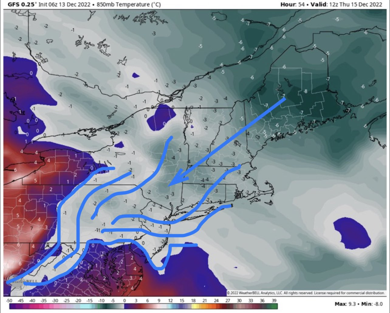
_________________
Mugs
AKA:King: Snow Weenie
Self Proclaimed
WINTER 2014-15 : 55.12" +.02 for 6 coatings (avg. 35")
WINTER 2015-16 Total - 29.8" (Avg 35")
WINTER 2016-17 : 39.5" so far

amugs- Advanced Forecaster - Mod

- Posts : 15156
Reputation : 213
Join date : 2013-01-07
Age : 54
Location : Hillsdale,NJ
heehaw453- Advanced Forecaster

- Posts : 3939
Reputation : 86
Join date : 2014-01-20
Location : Bedminster Township, PA Elevation 600' ASL
 Re: Dec 16 Just a little change can make the difference
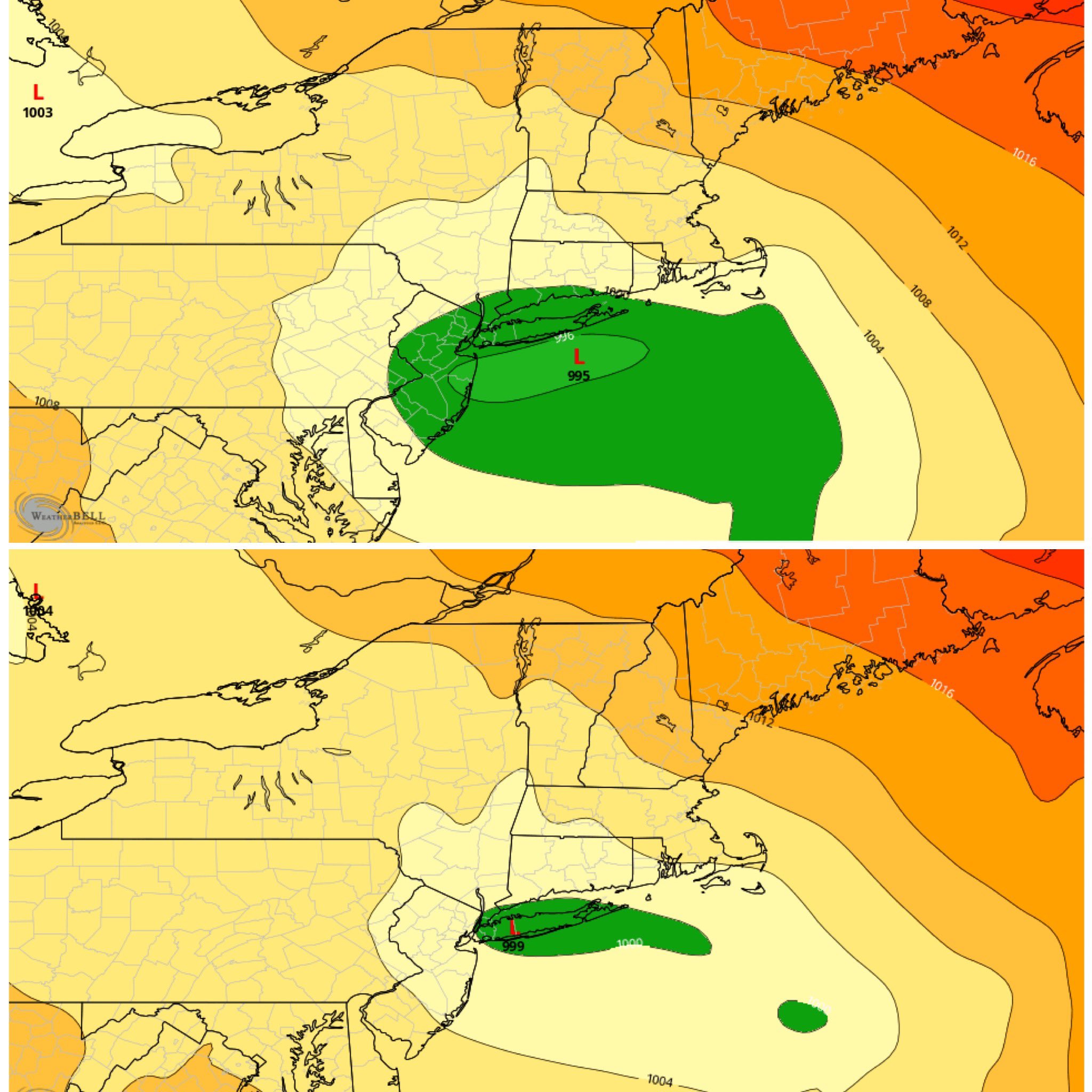
_________________
Mugs
AKA:King: Snow Weenie
Self Proclaimed
WINTER 2014-15 : 55.12" +.02 for 6 coatings (avg. 35")
WINTER 2015-16 Total - 29.8" (Avg 35")
WINTER 2016-17 : 39.5" so far

amugs- Advanced Forecaster - Mod

- Posts : 15156
Reputation : 213
Join date : 2013-01-07
Age : 54
Location : Hillsdale,NJ
 Re: Dec 16 Just a little change can make the difference
dsix85- Pro Enthusiast

- Posts : 351
Reputation : 8
Join date : 2014-01-01
Location : New York
sroc4 likes this post
 Re: Dec 16 Just a little change can make the difference
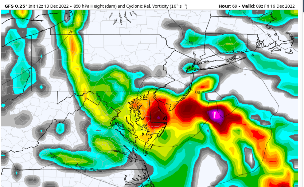
heehaw453- Advanced Forecaster

- Posts : 3939
Reputation : 86
Join date : 2014-01-20
Location : Bedminster Township, PA Elevation 600' ASL
sroc4 and weatherwatchermom like this post
 Re: Dec 16 Just a little change can make the difference
GEFS show this, is it onto something?? Man this is a hard forecast for sure. 25 -50 mile jogs mean a big difference (more rain, slop or snow depending) for a good many peeps on this board.
From Qtown over at 33nRain

_________________
Mugs
AKA:King: Snow Weenie
Self Proclaimed
WINTER 2014-15 : 55.12" +.02 for 6 coatings (avg. 35")
WINTER 2015-16 Total - 29.8" (Avg 35")
WINTER 2016-17 : 39.5" so far

amugs- Advanced Forecaster - Mod

- Posts : 15156
Reputation : 213
Join date : 2013-01-07
Age : 54
Location : Hillsdale,NJ
 Re: Dec 16 Just a little change can make the difference
amugs wrote:GEFS have a sweet look - Norm MacDonlad Rule at play here - wher eteh storm enters the West Coast latitude location is where it will exit on the East Coast = Norfolk, Va.
GEFS show this, is it onto something?? Man this is a hard forecast for sure. 25 -50 mile jogs mean a big difference (more rain, slop or snow depending) for a good many peeps on this board.
From Qtown over at 33nRain
The rain/snow line is still a little north of me in edison
phil155- Pro Enthusiast

- Posts : 497
Reputation : 4
Join date : 2019-12-16
 Re: Dec 16 Just a little change can make the difference
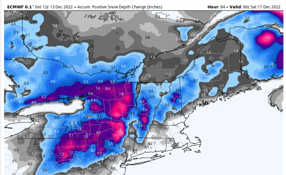
heehaw453- Advanced Forecaster

- Posts : 3939
Reputation : 86
Join date : 2014-01-20
Location : Bedminster Township, PA Elevation 600' ASL
 Re: Dec 16 Just a little change can make the difference
[Dec 13] We know a lot of people are excited about the potential late week winter storm. BUT it is still premature for any specific snowfall amounts. Check out the model error 3 days ahead of time. Stay tuned & be sure to get your forecast from official sources. #vtwx #nywx #snow pic.twitter.com/S4CndNtgm4
— NWS Burlington (@NWSBurlington) December 13, 2022
_________________
Mugs
AKA:King: Snow Weenie
Self Proclaimed
WINTER 2014-15 : 55.12" +.02 for 6 coatings (avg. 35")
WINTER 2015-16 Total - 29.8" (Avg 35")
WINTER 2016-17 : 39.5" so far

amugs- Advanced Forecaster - Mod

- Posts : 15156
Reputation : 213
Join date : 2013-01-07
Age : 54
Location : Hillsdale,NJ
heehaw453 likes this post
 Re: Dec 16 Just a little change can make the difference
ya I think I'm checking out on this one wasn't too hopeful to.begin with. If there's a sudden change I'll be happily surprised.heehaw453 wrote:Based on where the models are at this is probably a good expectation of actual snowfall from this event for the immediate area. Kinda makes me giggle a bit, but it is what it is. It won't take a dramatic change to track, but I think 100 miles or so SE is needed which would shift the 2-4" towards I95. At this range it's possible, but probably going to need to start seeing that on tomorrow's guidance, but I get those that have checked out of this one...

jmanley32- Senior Enthusiast

- Posts : 20646
Reputation : 108
Join date : 2013-12-12
Age : 43
Location : Yonkers, NY
heehaw453 and phil155 like this post
 Re: Dec 16 Just a little change can make the difference
jmanley32 wrote:ya I think I'm checking out on this one wasn't too hopeful to.begin with. If there's a sudden change I'll be happily surprised.heehaw453 wrote:Based on where the models are at this is probably a good expectation of actual snowfall from this event for the immediate area. Kinda makes me giggle a bit, but it is what it is. It won't take a dramatic change to track, but I think 100 miles or so SE is needed which would shift the 2-4" towards I95. At this range it's possible, but probably going to need to start seeing that on tomorrow's guidance, but I get those that have checked out of this one...
Watch it be all rain...

mikeypizano- Pro Enthusiast

- Posts : 1118
Reputation : 66
Join date : 2017-01-05
Age : 35
Location : Wilkes-Barre/Scranton, PA
RJB8525 likes this post
 Re: Dec 16 Just a little change can make the difference
heehaw453 wrote:Based on where the models are at this is probably a good expectation of actual snowfall from this event for the immediate area. Kinda makes me giggle a bit, but it is what it is. It won't take a dramatic change to track, but I think 100 miles or so SE is needed which would shift the 2-4" towards I95. At this range it's possible, but probably going to need to start seeing that on tomorrow's guidance, but I get those that have checked out of this one...
This is what I would expect as well.
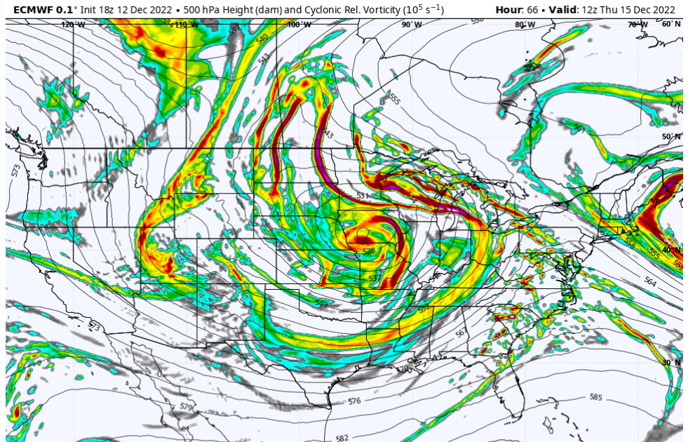
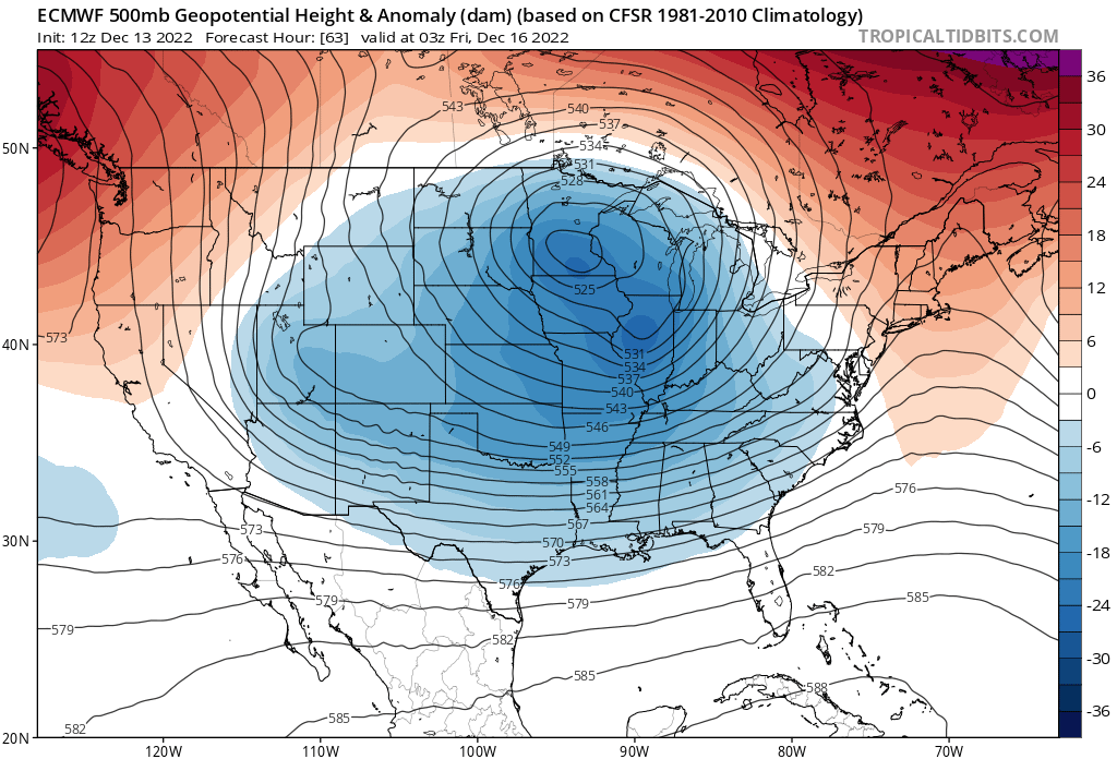
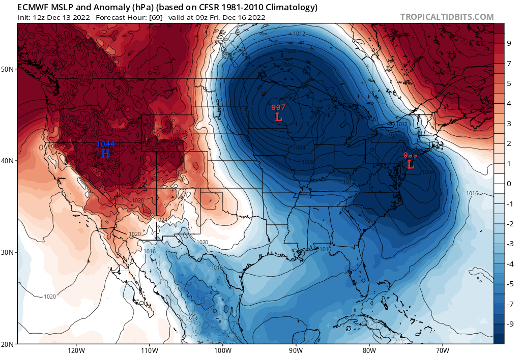
We have to stay true to basics sometimes. Here's the 500mb map valid for Thursday morning. We have heights rising ahead of the big and mighty ULL in the Midwest. The 500mb energy circulating around it has space to bring a primary low and cut it into the Lakes, thus torching all our mid-levels. The CAD is simply not strong enough to pop the secondary low south enough to bring the cold air back in.
_________________
_______________________________________________________________________________________________________
CLICK HERE to view NJ Strong Snowstorm Classifications
heehaw453 likes this post
 Re: Dec 16 Just a little change can make the difference

hyde345- Pro Enthusiast

- Posts : 1084
Reputation : 48
Join date : 2013-01-08
Location : Hyde Park, NY
SENJsnowman likes this post
 Re: Dec 16 Just a little change can make the difference
FRIDAY AFTERNOON...
* WHAT...Heavy mixed precipitation possible. Total snow
accumulations of 4 to 9 inches and ice accumulations up to
around two tenths of an inch possible. Winds could gust as high
as 35 mph.
* WHERE...In New York, Northern Oneida, Steuben, Schuyler,
Chemung, Tompkins, Madison, Southern Oneida, Cortland,
Chenango, Otsego, Tioga, Broome, Delaware and Sullivan
counties. In Pennsylvania, Bradford, Susquehanna, Northern
Wayne, Wyoming, Lackawanna, Luzerne, Pike and Southern Wayne
counties.
* WHEN...From Thursday morning through Friday afternoon.
* IMPACTS...Travel could be very difficult. The hazardous
conditions could impact the morning or evening commute.
* ADDITIONAL DETAILS...Snow and ice amounts will vary greatly
depending on location and elevation.
PRECAUTIONARY/PREPAREDNESS ACTIONS...
Monitor the latest forecasts for updates on this situation. Winter
storm warnings could be issued as the storm gets closer and
confidence increases.

mikeypizano- Pro Enthusiast

- Posts : 1118
Reputation : 66
Join date : 2017-01-05
Age : 35
Location : Wilkes-Barre/Scranton, PA
heehaw453 likes this post
 Re: Dec 16 Just a little change can make the difference
I-81 corridor is the place to be for this one. Either that or be over 1500' ASL.mikeypizano wrote:...WINTER STORM WATCH IN EFFECT FROM THURSDAY MORNING THROUGH
FRIDAY AFTERNOON...
* WHAT...Heavy mixed precipitation possible. Total snow
accumulations of 4 to 9 inches and ice accumulations up to
around two tenths of an inch possible. Winds could gust as high
as 35 mph.
* WHERE...In New York, Northern Oneida, Steuben, Schuyler,
Chemung, Tompkins, Madison, Southern Oneida, Cortland,
Chenango, Otsego, Tioga, Broome, Delaware and Sullivan
counties. In Pennsylvania, Bradford, Susquehanna, Northern
Wayne, Wyoming, Lackawanna, Luzerne, Pike and Southern Wayne
counties.
* WHEN...From Thursday morning through Friday afternoon.
* IMPACTS...Travel could be very difficult. The hazardous
conditions could impact the morning or evening commute.
* ADDITIONAL DETAILS...Snow and ice amounts will vary greatly
depending on location and elevation.
PRECAUTIONARY/PREPAREDNESS ACTIONS...
Monitor the latest forecasts for updates on this situation. Winter
storm warnings could be issued as the storm gets closer and
confidence increases.
heehaw453- Advanced Forecaster

- Posts : 3939
Reputation : 86
Join date : 2014-01-20
Location : Bedminster Township, PA Elevation 600' ASL
Page 2 of 8 •  1, 2, 3, 4, 5, 6, 7, 8

 Home
Home