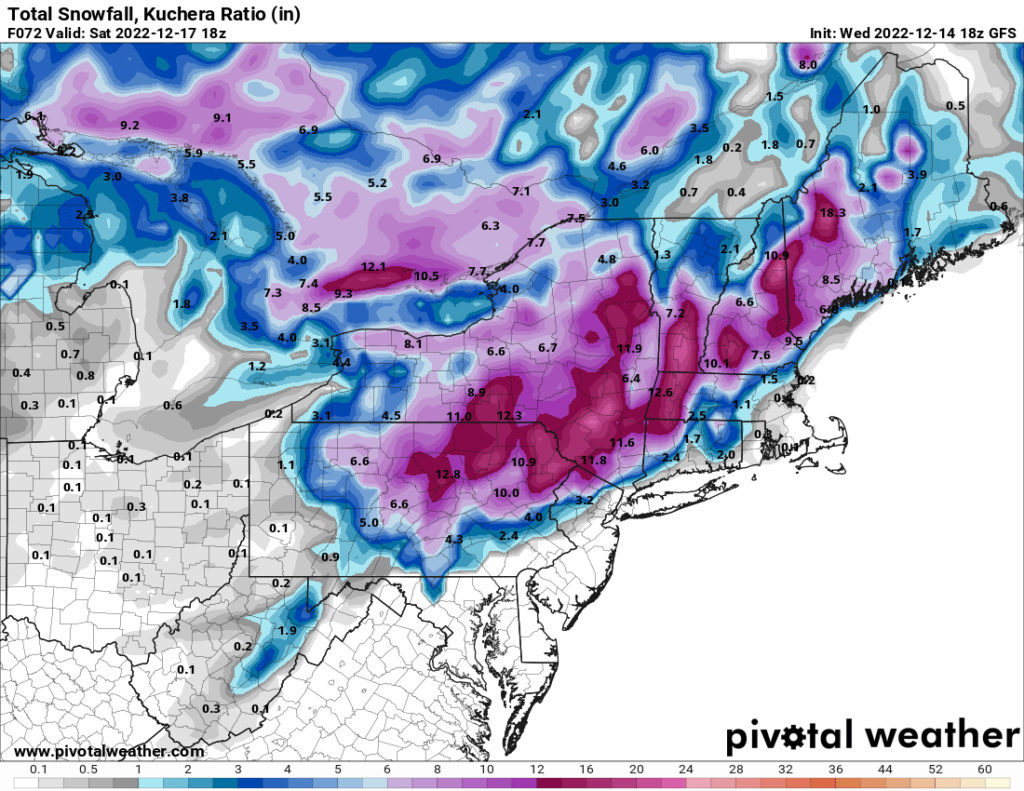
Dec 16 Just a little change can make the difference
Page 4 of 8 •  1, 2, 3, 4, 5, 6, 7, 8
 Re: Dec 16 Just a little change can make the difference
amugs- Advanced Forecaster - Mod

- Posts : 15156
Join date : 2013-01-07
heehaw453 likes this post
 Re: Dec 16 Just a little change can make the difference

amugs- Advanced Forecaster - Mod

- Posts : 15156
Join date : 2013-01-07
heehaw453- Advanced Forecaster

- Posts : 3939
Reputation : 86
Join date : 2014-01-20
Location : Bedminster Township, PA Elevation 600' ASL
 Re: Dec 16 Just a little change can make the difference
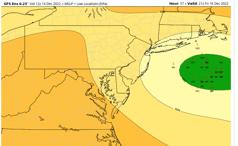
The NAM shifted SE as well, is more in line withGFS. The 6Z Euro held onto the CAD more as well giving a SE bump to snow,mix boundary. I am not disocunting the GFS at this time and has been advertising this SE trajectory off Norfolk Va for a couple days now. From 33nRain wx board pic.twitter.com/ZDZxw1OXIy
— Al Mugno (@MugnoaAl) December 14, 2022
_________________
Mugs
AKA:King: Snow Weenie
Self Proclaimed
WINTER 2014-15 : 55.12" +.02 for 6 coatings (avg. 35")
WINTER 2015-16 Total - 29.8" (Avg 35")
WINTER 2016-17 : 39.5" so far

amugs- Advanced Forecaster - Mod

- Posts : 15156
Reputation : 213
Join date : 2013-01-07
Age : 54
Location : Hillsdale,NJ
 Re: Dec 16 Just a little change can make the difference

Have to look at 500, mid level centers to see whats what.
_________________
Mugs
AKA:King: Snow Weenie
Self Proclaimed
WINTER 2014-15 : 55.12" +.02 for 6 coatings (avg. 35")
WINTER 2015-16 Total - 29.8" (Avg 35")
WINTER 2016-17 : 39.5" so far

amugs- Advanced Forecaster - Mod

- Posts : 15156
Reputation : 213
Join date : 2013-01-07
Age : 54
Location : Hillsdale,NJ
 Re: Dec 16 Just a little change can make the difference
Need about 2 more tics. If the GFS is truly leading the way it seems feasible for I95 and points NW for some accumulations. Synoptically it makes sense for SE push.amugs wrote:12Z EURO takes a slight tick SE
Have to look at 500, mid level centers to see whats what.
heehaw453- Advanced Forecaster

- Posts : 3939
Reputation : 86
Join date : 2014-01-20
Location : Bedminster Township, PA Elevation 600' ASL
 Re: Dec 16 Just a little change can make the difference

_________________
Mugs
AKA:King: Snow Weenie
Self Proclaimed
WINTER 2014-15 : 55.12" +.02 for 6 coatings (avg. 35")
WINTER 2015-16 Total - 29.8" (Avg 35")
WINTER 2016-17 : 39.5" so far

amugs- Advanced Forecaster - Mod

- Posts : 15156
Reputation : 213
Join date : 2013-01-07
Age : 54
Location : Hillsdale,NJ
 Re: Dec 16 Just a little change can make the difference
heehaw453 wrote:Need about 2 more tics. If the GFS is truly leading the way it seems feasible for I95 and points NW for some accumulations. Synoptically it makes sense for SE push.amugs wrote:12Z EURO takes a slight tick SE
Have to look at 500, mid level centers to see whats what.
I vehemently agree we have about abother 20-25 miles jog left maybe more. Th emid level torch I have not looked at yet for EURO but seeing the SLP heading East is better news for those who were fringe a day ago and true slop. Still have some time peeps.
Again beyond day 6 GFS is mal but is better at Miller B's with teh newest upgrade? We'll see but I know they have been tweaking this model since the upgrade a couple of weeks ago.
_________________
Mugs
AKA:King: Snow Weenie
Self Proclaimed
WINTER 2014-15 : 55.12" +.02 for 6 coatings (avg. 35")
WINTER 2015-16 Total - 29.8" (Avg 35")
WINTER 2016-17 : 39.5" so far

amugs- Advanced Forecaster - Mod

- Posts : 15156
Reputation : 213
Join date : 2013-01-07
Age : 54
Location : Hillsdale,NJ
 Re: Dec 16 Just a little change can make the difference
amugs wrote:heehaw453 wrote:Need about 2 more tics. If the GFS is truly leading the way it seems feasible for I95 and points NW for some accumulations. Synoptically it makes sense for SE push.amugs wrote:12Z EURO takes a slight tick SE
Have to look at 500, mid level centers to see whats what.
I vehemently agree we have about abother 20-25 miles jog left maybe more. Th emid level torch I have not looked at yet for EURO but seeing the SLP heading East is better news for those who were fringe a day ago and true slop. Still have some time peeps.
Again beyond day 6 GFS is mal but is better at Miller B's with teh newest upgrade? We'll see but I know they have been tweaking this model since the upgrade a couple of weeks ago.
When we do start taking the NAM into consideration?

mikeypizano- Pro Enthusiast

- Posts : 1118
Reputation : 66
Join date : 2017-01-05
Age : 35
Location : Wilkes-Barre/Scranton, PA
 Re: Dec 16 Just a little change can make the difference
mikeypizano wrote:amugs wrote:heehaw453 wrote:Need about 2 more tics. If the GFS is truly leading the way it seems feasible for I95 and points NW for some accumulations. Synoptically it makes sense for SE push.amugs wrote:12Z EURO takes a slight tick SE
Have to look at 500, mid level centers to see whats what.
I vehemently agree we have about abother 20-25 miles jog left maybe more. Th emid level torch I have not looked at yet for EURO but seeing the SLP heading East is better news for those who were fringe a day ago and true slop. Still have some time peeps.
Again beyond day 6 GFS is mal but is better at Miller B's with teh newest upgrade? We'll see but I know they have been tweaking this model since the upgrade a couple of weeks ago.
When we do start taking the NAM into consideration?
I would say this coming 18z run/tonight’s 00z - as it’ll be within 24ish hours of start time, generally.
MattyICE- Advanced Forecaster

- Posts : 250
Reputation : 6
Join date : 2017-11-10
Age : 39
Location : Clifton, NJ (Eastern Passaic County)
 Re: Dec 16 Just a little change can make the difference
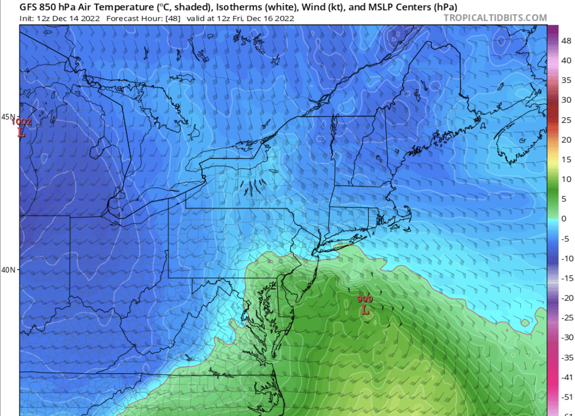
850's plenty cold
7
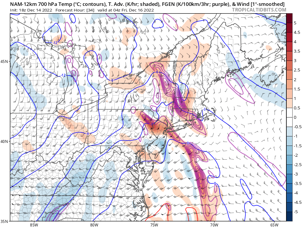
700 Too
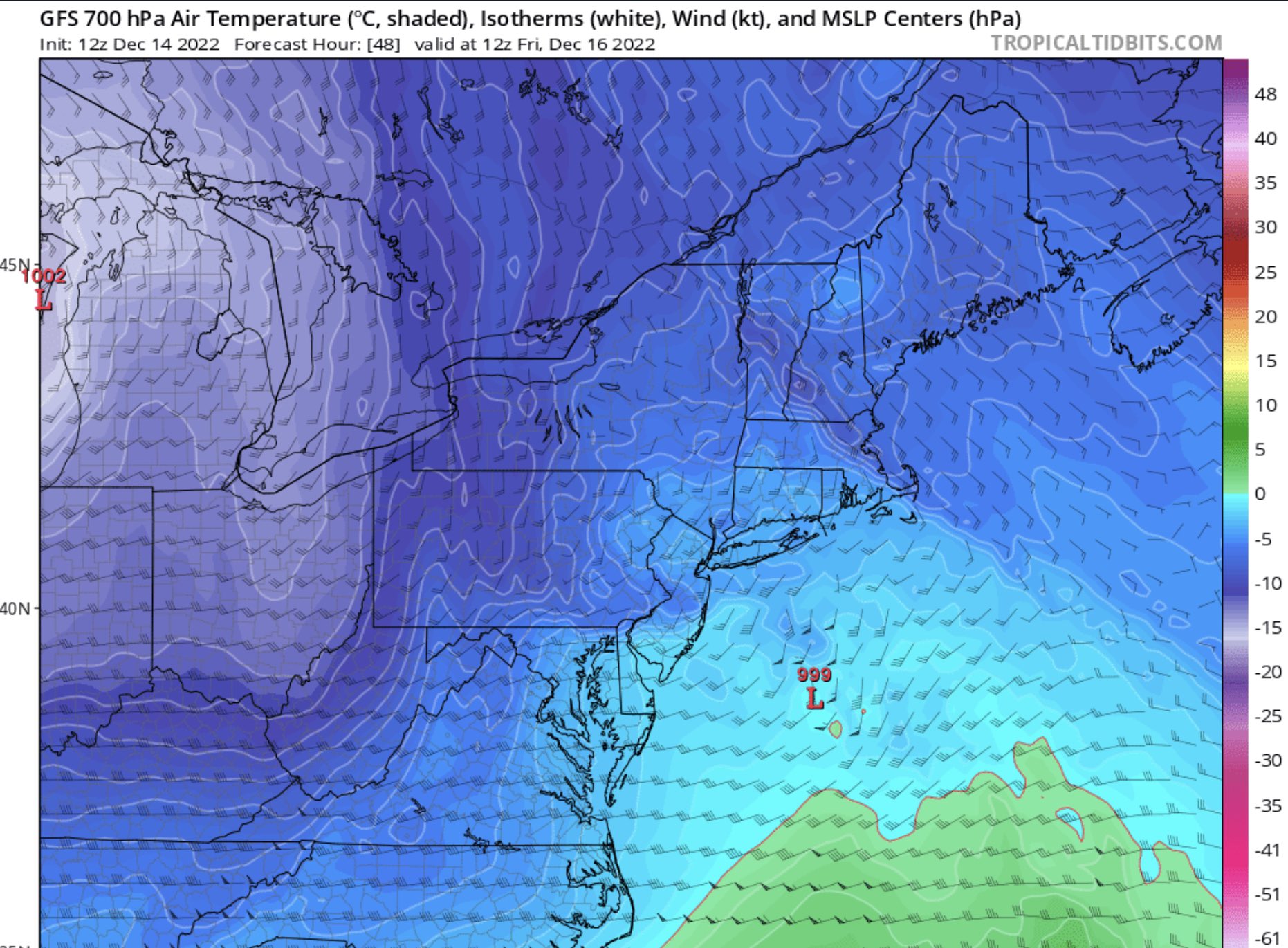
Now Euro - but again it has a stupidly wrong double barrel Low that is screwing up these maps so I say pull these 50 miles SE and there you have it
N wind as well at 700

850
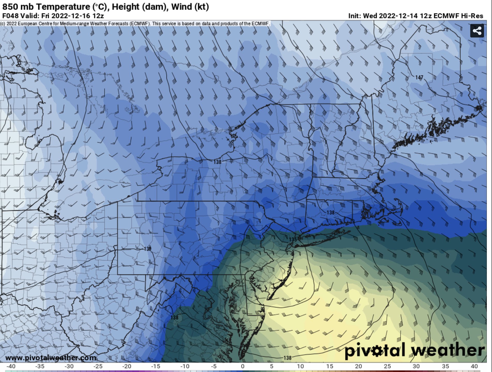
This is where i'd say this line should be (heavy black line), between warm and cold air that supports wintry precip.

Problem is the boundary layer, surface temps are above freezing but with heavier precip and darkness we at 33* can overcome this with heavier rates.
Also the further east this torm gets it allows more cold air to come in, less resistance.
_________________
Mugs
AKA:King: Snow Weenie
Self Proclaimed
WINTER 2014-15 : 55.12" +.02 for 6 coatings (avg. 35")
WINTER 2015-16 Total - 29.8" (Avg 35")
WINTER 2016-17 : 39.5" so far

amugs- Advanced Forecaster - Mod

- Posts : 15156
Reputation : 213
Join date : 2013-01-07
Age : 54
Location : Hillsdale,NJ
CPcantmeasuresnow likes this post
 Re: Dec 16 Just a little change can make the difference
Still a decent track difference between the Euro and GFS for tomorrow night & Friday. But for all the bashing the GFS takes (often deservedly so), the Euro has trended more offshore and closer the GFS solution. pic.twitter.com/9cmTyGKLqf
— eweather (@Eweather13) December 14, 2022
_________________
Mugs
AKA:King: Snow Weenie
Self Proclaimed
WINTER 2014-15 : 55.12" +.02 for 6 coatings (avg. 35")
WINTER 2015-16 Total - 29.8" (Avg 35")
WINTER 2016-17 : 39.5" so far

amugs- Advanced Forecaster - Mod

- Posts : 15156
Reputation : 213
Join date : 2013-01-07
Age : 54
Location : Hillsdale,NJ
 Re: Dec 16 Just a little change can make the difference
The GFS track would bring snow accumulations to the I95 IMO. Especially if it starts to deepen as it moves towards the BM, then it can drag in colder air faster. I've seen worse setups bring snow to I95 before...amugs wrote:@HAWStill a decent track difference between the Euro and GFS for tomorrow night & Friday. But for all the bashing the GFS takes (often deservedly so), the Euro has trended more offshore and closer the GFS solution. pic.twitter.com/9cmTyGKLqf
— eweather (@Eweather13) December 14, 2022
heehaw453- Advanced Forecaster

- Posts : 3939
Reputation : 86
Join date : 2014-01-20
Location : Bedminster Township, PA Elevation 600' ASL
phil155 likes this post
 Re: Dec 16 Just a little change can make the difference
heehaw453 wrote:The GFS track would bring snow accumulations to the I95 IMO. Especially if it starts to deepen as it moves towards the BM, then it can drag in colder air faster. I've seen worse setups bring snow to I95 before...amugs wrote:@HAWStill a decent track difference between the Euro and GFS for tomorrow night & Friday. But for all the bashing the GFS takes (often deservedly so), the Euro has trended more offshore and closer the GFS solution. pic.twitter.com/9cmTyGKLqf
— eweather (@Eweather13) December 14, 2022
And about 25 miles more SE would be even better
_________________
Mugs
AKA:King: Snow Weenie
Self Proclaimed
WINTER 2014-15 : 55.12" +.02 for 6 coatings (avg. 35")
WINTER 2015-16 Total - 29.8" (Avg 35")
WINTER 2016-17 : 39.5" so far

amugs- Advanced Forecaster - Mod

- Posts : 15156
Reputation : 213
Join date : 2013-01-07
Age : 54
Location : Hillsdale,NJ
CPcantmeasuresnow and phil155 like this post
 Re: Dec 16 Just a little change can make the difference
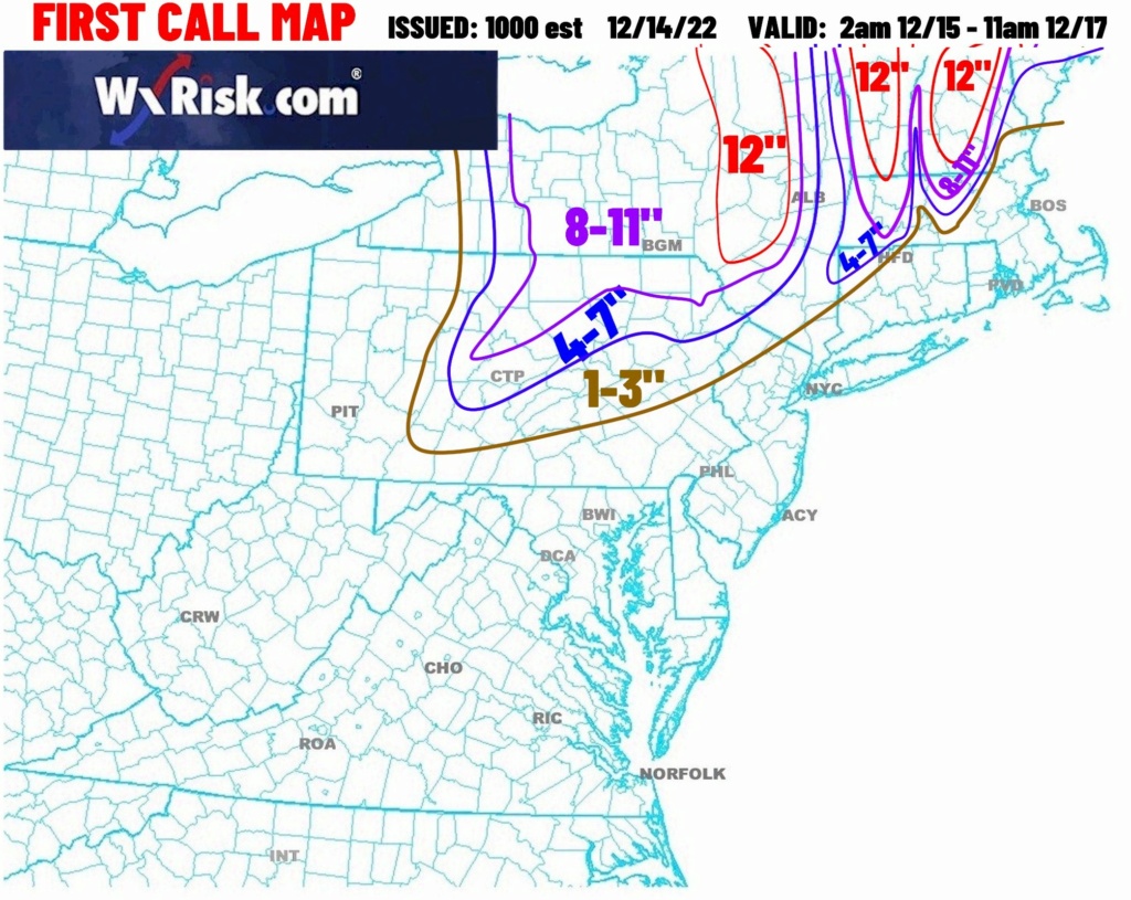
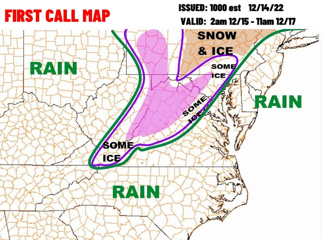
FIRST CALL MAPS
"The main change in the FIRST CALL forecast in the lower Middle Atlantic, the northern Mid-Atlantic, and in New England is that the model data last night and early this morning is actually a couple of degrees warmer. This is not a surprise given the fact that the Coastal LOW is going to be tracking in land which produces an easterly wind. And since the ocean water temperatures in mid-December are still relatively mild, easterly winds bring in mild faster. Parenthetically, if we had the exact same storm track and set up during the early or mid-March this would be primarily a snow event for much of the middle Atlantic and New England since the ocean water temperatures in March would be much colder.
In the Shenandoah Valley, western Maryland, the eastern panhandle of West Virginia the short-range model data shows temperatures DO NOT drop down to 28 degrees early Thursday morning. The new model data is a few degrees warmer, so temperatures stay around 31 or 32 degrees from 2 am to noon on Thursday. This significantly reduces the threat of major ice buildup. If you look at the ICE forecast map you will see that we have removed the term HEAVY ICE because of these slightly milder temperatures.
Further to the north, the lightly milder temperatures at the surface and the mid-levels of the atmosphere has increased the threat of this being a snow elevation event. By that we mean the precipitation might be a snow rain mix at 500 or 800 foot elevation, but it could be mostly also above 1000 ft or 1500 foot elevation. This means that the snowfall amounts in places such as the Hudson River Valley and the Connecticut River Valley could end up being several inches LESS than the immediate mountains and hills on either side of these river valleys. More information on waiting times and everything else."
_________________
-Alex Iannone-

aiannone- Senior Enthusiast - Mod

- Posts : 4828
Reputation : 92
Join date : 2013-01-07
Location : Saint James, LI (Northwest Suffolk Co.)
 Re: Dec 16 Just a little change can make the difference
The river towns in orange county or as low as 150 feet whereas the northern and western parts of the county run upwards of 1000 to 1200 feet. Where Doc and I are about 5 miles apart is about 6 to 700 feet above sea level I don’t see us getting in on those higher amounts but I hope I’m wrong. Now where Damien is in northern orange I could definitely see it

CPcantmeasuresnow- Wx Statistician Guru

- Posts : 7288
Reputation : 230
Join date : 2013-01-07
Age : 103
Location : Eastern Orange County, NY
Frank_Wx, heehaw453 and SENJsnowman like this post
 Re: Dec 16 Just a little change can make the difference
Yesterdays EPS 12z
Todays 12z
_________________
"In weather and in life, there's no winning and losing; there's only winning and learning."
WINTER 2012/2013 TOTALS 43.65"WINTER 2017/2018 TOTALS 62.85" WINTER 2022/2023 TOTALS 4.9"
WINTER 2013/2014 TOTALS 64.85"WINTER 2018/2019 TOTALS 14.25" WINTER 2023/2024 TOTALS 13.1"
WINTER 2014/2015 TOTALS 71.20"WINTER 2019/2020 TOTALS 6.35" WINTER 2024/2025 TOTALS 0.00
WINTER 2015/2016 TOTALS 35.00"WINTER 2020/2021 TOTALS 37.75"
WINTER 2016/2017 TOTALS 42.25"WINTER 2021/2022 TOTALS 31.65"

sroc4- Admin

- Posts : 8458
Reputation : 302
Join date : 2013-01-07
Location : Wading River, LI
 Re: Dec 16 Just a little change can make the difference
CPcantmeasuresnow wrote:Winter storm watch just posted for orange county in Southeast New York. Calling for a possible 7 inches with heavier amounts possible. Not sure I see that in the lower elevation river towns of orange county but I can see the western and northern areas getting into totals like that.
The river towns in orange county or as low as 150 feet whereas the northern and western parts of the county run upwards of 1000 to 1200 feet. Where Doc and I are about 5 miles apart is about 6 to 700 feet above sea level I don’t see us getting in on those higher amounts but I hope I’m wrong. Now where Damien is in northern orange I could definitely see it
Welcome back CP. Not the same without you posting.
Cheers to being back

_________________
"In weather and in life, there's no winning and losing; there's only winning and learning."
WINTER 2012/2013 TOTALS 43.65"WINTER 2017/2018 TOTALS 62.85" WINTER 2022/2023 TOTALS 4.9"
WINTER 2013/2014 TOTALS 64.85"WINTER 2018/2019 TOTALS 14.25" WINTER 2023/2024 TOTALS 13.1"
WINTER 2014/2015 TOTALS 71.20"WINTER 2019/2020 TOTALS 6.35" WINTER 2024/2025 TOTALS 0.00
WINTER 2015/2016 TOTALS 35.00"WINTER 2020/2021 TOTALS 37.75"
WINTER 2016/2017 TOTALS 42.25"WINTER 2021/2022 TOTALS 31.65"

sroc4- Admin

- Posts : 8458
Reputation : 302
Join date : 2013-01-07
Location : Wading River, LI
Frank_Wx, amugs, CPcantmeasuresnow, essexcountypete and heehaw453 like this post

dkodgis- Senior Enthusiast

- Posts : 2694
Reputation : 98
Join date : 2013-12-29
CPcantmeasuresnow likes this post
 Re: Dec 16 Just a little change can make the difference
heehaw453- Advanced Forecaster

- Posts : 3939
Reputation : 86
Join date : 2014-01-20
Location : Bedminster Township, PA Elevation 600' ASL
hyde345- Pro Enthusiast

- Posts : 1084
Reputation : 48
Join date : 2013-01-08
Location : Hyde Park, NY
 Re: Dec 16 Just a little change can make the difference
I was surprised to see that my neck of the woods is expected to get maybe over 2" of rain and regular 30+ mph winds from this. Not that big of a deal, but we'll feel it, that's for sure. lol!
So, hopefully, things work out for the northern half of the board. You look at the r/s line Mugsy drew in the map up above and it goes right through the New York island. If he's right, that would be a great, unexpected outcome for a lot of our forum members! Here's hoping...and thanks a million to all our mets for the time and effort you all give in the tracking and forecasting!
SENJsnowman- Senior Enthusiast

- Posts : 1201
Reputation : 61
Join date : 2017-01-06
Age : 51
Location : Long Branch, NJ
Frank_Wx, sroc4 and kalleg like this post
 Re: Dec 16 Just a little change can make the difference
EST FRIDAY...
* WHAT...Mixed precipitation expected. Total snow accumulations of
1 to 6 inches and ice accumulations of up to two tenths of an
inch. Winds gusting as high as 40 mph.
* WHERE...Lackawanna and Luzerne counties.
* WHEN...From 7 AM Thursday to 4 PM EST Friday.
* IMPACTS...Travel could be very difficult. The hazardous
conditions could impact the morning or evening commute.
* ADDITIONAL DETAILS...Ice and snow will be heavy and wet which
could bring down branches. Power outages are possible. The
highest snow amounts will be across the highest terrain.
PRECAUTIONARY/PREPAREDNESS ACTIONS...
Slow down and use caution while traveling.
The latest road conditions for the state you are calling from can
be obtained by calling 5 1 1.
The Pennsylvania Department of Transportation and Pennsylvania
Turnpike Commission remind motorist to adjust speeds based on
driving conditions as winter weather impacts Pennsylvania
roadways. Visit www.511pa.com for the latest travel, roadways,
and traffic conditions.

mikeypizano- Pro Enthusiast

- Posts : 1118
Reputation : 66
Join date : 2017-01-05
Age : 35
Location : Wilkes-Barre/Scranton, PA
heehaw453 likes this post
 Re: Dec 16 Just a little change can make the difference
_________________
Mugs
AKA:King: Snow Weenie
Self Proclaimed
WINTER 2014-15 : 55.12" +.02 for 6 coatings (avg. 35")
WINTER 2015-16 Total - 29.8" (Avg 35")
WINTER 2016-17 : 39.5" so far

amugs- Advanced Forecaster - Mod

- Posts : 15156
Reputation : 213
Join date : 2013-01-07
Age : 54
Location : Hillsdale,NJ
 Re: Dec 16 Just a little change can make the difference
CPcantmeasuresnow wrote:Winter storm watch just posted for orange county in Southeast New York. Calling for a possible 7 inches with heavier amounts possible. Not sure I see that in the lower elevation river towns of orange county but I can see the western and northern areas getting into totals like that.
The river towns in orange county or as low as 150 feet whereas the northern and western parts of the county run upwards of 1000 to 1200 feet. Where Doc and I are about 5 miles apart is about 6 to 700 feet above sea level I don’t see us getting in on those higher amounts but I hope I’m wrong. Now where Damien is in northern orange I could definitely see it
CP, I have been watching this trend slowly in our favor the last few days.Went from hazardous weather warning to a now winter storm watch.A solid 4 at this juncture is a good shot up from maybe an inch of slop yesterday.Mugsy showing those GFS and Euro maps ticking this S and E seem to be coming into play.He has been honking over that CAD effect all week.Let's see tomorrow morning where we stand on this one.
Still have a few inch snowpack here, guess you do as well.Down by the Red Apple Rest, barely an inch.That's the river elevation area, up my hill on the Orange Tpk, we are up that 6-700 feet and that does make a difference for sure.
Good to have you back Buddy, winter storms would be no fun without you reporting!

docstox12- Wx Statistician Guru

- Posts : 8617
Reputation : 222
Join date : 2013-01-07
Age : 74
Location : Monroe NY
 Re: Dec 16 Just a little change can make the difference
CP glad to see you back my man, we are getting the band back together. Where be Snowy??
_________________
Mugs
AKA:King: Snow Weenie
Self Proclaimed
WINTER 2014-15 : 55.12" +.02 for 6 coatings (avg. 35")
WINTER 2015-16 Total - 29.8" (Avg 35")
WINTER 2016-17 : 39.5" so far

amugs- Advanced Forecaster - Mod

- Posts : 15156
Reputation : 213
Join date : 2013-01-07
Age : 54
Location : Hillsdale,NJ
 Re: Dec 16 Just a little change can make the difference
_________________
_______________________________________________________________________________________________________
CLICK HERE to view NJ Strong Snowstorm Classifications
CPcantmeasuresnow likes this post
Page 4 of 8 •  1, 2, 3, 4, 5, 6, 7, 8

 Home
Home