02/14 Godzilla Storm Part 2 Obs. Thread
+66
Bielak716
essexcountypete
klrak
dad4twoboys
marin1804
1190ftalt
nyrfan31
Grselig
SNOW MAN
rb924119
Radz
Gator99
HeresL
freezerburn
Dunnzoo
GreyBeard
Bigbee
Sharon L
meatsanwch
Aiosamoney21
Joe Snow
nofoboater
Dtone
colosa4
BklynKel
Taffy
gigs68
pdubz
shawnerak
hyde345
tigernumba1
Artechmetals
yorkseer
cooladi
bloc1357
static2987
Sanchize06
le88kb
mako460
aiannone
nujerzeedevil
2004blackwrx
jtswife
Quietace
jimv45
Vinnydula
skinsfan1177
jmanley32
Math23x7
Fededle22
docstox12
goalscore
nutleyblizzard
sroc4
CPcantmeasuresnow
amugs
WeatherBob
NjWeatherGuy
dolphins222
Mathgod55
Yschiff
HectorO
oldtimer
Scullybutcher
RJB8525
Frank_Wx
70 posters
Page 1 of 20
Page 1 of 20 • 1, 2, 3 ... 10 ... 20 
 02/14 Godzilla Storm Part 2 Obs. Thread
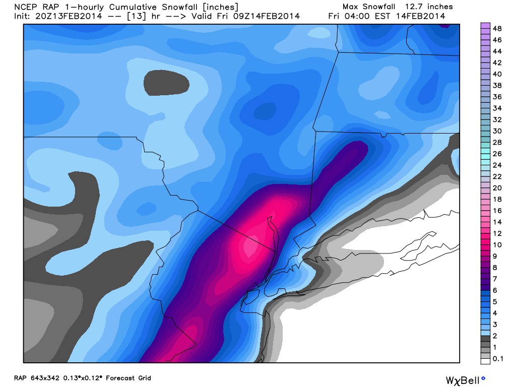
Part 2 of this storm is expected to arrive between 8pm-10pm this evening. Due to the positioning of the 850mb and 700mb low's, as well as high lapse rates, there could be thunder snow which would produce snowfall rates of 2+ inches per hour tonight in some area.
I expect my final snowfall map from last night to verify in most places. From part 1, we picked up between 8-14 inches of snow region wide. Isolated places 15-16 inches. For part 2, I think we are looking at 3-6+ inches of snow on Long Island / Central NJ / Coastal NJ / Eastern PA, and 4-8+ inches of snow for NYC / NNJ / HV. This will take snow totals region wide anywhere from 12-20 inches. Godzilla storm for sure!

You can see there is already convection developing around the core of the upper level low in northeast VA. Once this low tracks off our coast, cold air will come crashing inland. We may start as rain / mix, but I think we quickly change to snow. Notice I put "+" signs when I mentioned possible snow amounts. If there is training snow, someone could easily see more than 8 inches out of this event tonight.
Lets see how this goes!
I expect my final snowfall map from last night to verify in most places. From part 1, we picked up between 8-14 inches of snow region wide. Isolated places 15-16 inches. For part 2, I think we are looking at 3-6+ inches of snow on Long Island / Central NJ / Coastal NJ / Eastern PA, and 4-8+ inches of snow for NYC / NNJ / HV. This will take snow totals region wide anywhere from 12-20 inches. Godzilla storm for sure!

You can see there is already convection developing around the core of the upper level low in northeast VA. Once this low tracks off our coast, cold air will come crashing inland. We may start as rain / mix, but I think we quickly change to snow. Notice I put "+" signs when I mentioned possible snow amounts. If there is training snow, someone could easily see more than 8 inches out of this event tonight.
Lets see how this goes!
_________________
_______________________________________________________________________________________________________
CLICK HERE to view NJ Strong Snowstorm Classifications
 Re: 02/14 Godzilla Storm Part 2 Obs. Thread
my popcorn's ready for tonight

RJB8525- Senior Enthusiast

- Posts : 1994
Reputation : 28
Join date : 2013-02-06
Age : 38
Location : Hackettstown, NJ
 Re: 02/14 Godzilla Storm Part 2 Obs. Thread
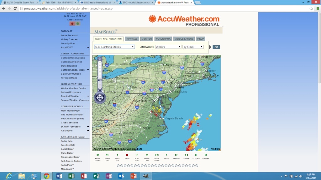
Current lightning!


_________________
_______________________________________________________________________________________________________
CLICK HERE to view NJ Strong Snowstorm Classifications
 Re: 02/14 Godzilla Storm Part 2 Obs. Thread
Back in from 4 hours of blowing. Did have to get a brake away bolt, when I was 1/2 finished. Now time for a shot of vodka. Thanks for the update on tonight's totals because that what I wanted to know when I got back in
Scullybutcher- Pro Enthusiast

- Posts : 544
Reputation : 16
Join date : 2013-02-06
Location : North Smithtown, western Suffolk county, long island
 Re: 02/14 Godzilla Storm Part 2 Obs. Thread
Thanks Frank for update on part 2
oldtimer- Senior Enthusiast

- Posts : 1103
Reputation : 14
Join date : 2013-01-16
Age : 78
Location : Port Jefferson Station Suffolk County
 Re: 02/14 Godzilla Storm Part 2 Obs. Thread
Locking these threads too early. Anyways, I'm done, my back is shot and I hope Saturday is nothing but a dusting. At 28 I have the back of a 95 year old right now.

HectorO- Pro Enthusiast

- Posts : 977
Reputation : 27
Join date : 2013-01-11
 Re: 02/14 Godzilla Storm Part 2 Obs. Thread
Frank what do you think amounts in the jfk area will be tonight?
Yschiff- Posts : 139
Reputation : 1
Join date : 2014-01-04
Location : Far Rockaway New York
 Re: 02/14 Godzilla Storm Part 2 Obs. Thread
Scullybutcher wrote:Back in from 4 hours of blowing. Did have to get a brake away bolt, when I was 1/2 finished. Now time for a shot of vodka. Thanks for the update on tonight's totals because that what I wanted to know when I got back in
Just made margarita, dreaming of being on a tropic island somewhere.

HectorO- Pro Enthusiast

- Posts : 977
Reputation : 27
Join date : 2013-01-11
 Re: 02/14 Godzilla Storm Part 2 Obs. Thread
Frank, big THANK YOU! Your tireless effort and spot on accuracy is greatly appreciated by myself and I'm sure countless others. Keep up the great job you're doing, and thanks again from West Islip.

Mathgod55- Posts : 60
Reputation : 0
Join date : 2013-01-08
Location : West Islip, NyY
 Re: 02/14 Godzilla Storm Part 2 Obs. Thread
great work frank, appreciate it.
i know this is prob not the thread for this question, but i will ask it anyways because why not, but after this storm and saturdays whatever happens, is this is it for winter?
i ask that, because while i am just learning and do not have even close to the knowledge that you and many other members on here have of reading long range maps, etc, by looking at some simple long range forecasts, all i see is 40s and 50s through mid march.
i hope that is not the case
dolphins222- Posts : 26
Reputation : 0
Join date : 2013-10-04
 Re: 02/14 Godzilla Storm Part 2 Obs. Thread
dolphins222 wrote:great work frank, appreciate it.
i know this is prob not the thread for this question, but i will ask it anyways because why not, but after this storm and saturdays whatever happens, is this is it for winter?
i ask that, because while i am just learning and do not have even close to the knowledge that you and many other members on here have of reading long range maps, etc, by looking at some simple long range forecasts, all i see is 40s and 50s through mid march.
i hope that is not the case
I think the next 7-10 days will feature above normal temperatures with 1 or 2 rain events as well. By the very end of the month into early March, a winter pattern could return. Too early to tell, but that is just my hunch.
_________________
_______________________________________________________________________________________________________
CLICK HERE to view NJ Strong Snowstorm Classifications
 Re: 02/14 Godzilla Storm Part 2 Obs. Thread
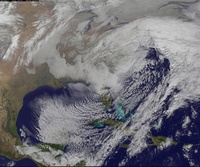
Well I hurt my back again, should have shoveled before it compacted, was like 13"+ before but down to around 9-10" ish with compacting. Seeing crazy precip amnts on some short range models, some have it in eastern PA and some have it right around NYC, compromise and you have NJ!
NjWeatherGuy- Advanced Forecaster

- Posts : 4100
Reputation : 28
Join date : 2013-01-06
Location : Belle Mead, NJ

NjWeatherGuy- Advanced Forecaster

- Posts : 4100
Reputation : 28
Join date : 2013-01-06
Location : Belle Mead, NJ
 Re: 02/14 Godzilla Storm Part 2 Obs. Thread
I think we should give credit to Mount Holly and Upton NWS. I think they did a great job forecasting the snow amounts with this storm!

WeatherBob- Meteorologist

- Posts : 683
Reputation : 83
Join date : 2013-12-13
Location : Caldwell, NJ - NW Essex County - Altitude 500 FT
 Re: 02/14 Godzilla Storm Part 2 Obs. Thread
well i deff trust your analysis so lets hope winter comes back at end of month into march.Frank_Wx wrote:dolphins222 wrote:great work frank, appreciate it.
i know this is prob not the thread for this question, but i will ask it anyways because why not, but after this storm and saturdays whatever happens, is this is it for winter?
i ask that, because while i am just learning and do not have even close to the knowledge that you and many other members on here have of reading long range maps, etc, by looking at some simple long range forecasts, all i see is 40s and 50s through mid march.
i hope that is not the case
I think the next 7-10 days will feature above normal temperatures with 1 or 2 rain events as well. By the very end of the month into early March, a winter pattern could return. Too early to tell, but that is just my hunch.
truth is, as much as we all love the snow, after this coming saturdays storm, a week of 40s and 50s would not be the worst thing.
i just hope we get at least 1 more major snowstorm before the winter is over.
lets also hope tonight overachieves.
dolphins222- Posts : 26
Reputation : 0
Join date : 2013-10-04
 Re: 02/14 Godzilla Storm Part 2 Obs. Thread
Okay, down at my gray friend Dino's (ILA ALL THE WAY!! Long shoreman) Anyway having a Happy Hour and then dinner and drinks.
Okay the temp is 32 at my house and things are getting icy, light sleet and freezing drizzle - disgusting. The convection is inline with the models NAM and UKIE for 4-8"+. for our NNJ, HV, EPA area and SW CT gets crushed with about a foot.
This storm will go down in the annals of the history books for a number of aspects:
1. Duration
2. Snowfall amounts
3. Set up - H5 and players involved
4. Ice in the south
5. Vast area it affected
More but can't think right now - having my second red hot - WOOPWOOP!!
_________________
Mugs
AKA:King: Snow Weenie
Self Proclaimed
WINTER 2014-15 : 55.12" +.02 for 6 coatings (avg. 35")
WINTER 2015-16 Total - 29.8" (Avg 35")
WINTER 2016-17 : 39.5" so far

amugs- Advanced Forecaster - Mod

- Posts : 15156
Reputation : 213
Join date : 2013-01-07
Age : 54
Location : Hillsdale,NJ
 Re: 02/14 Godzilla Storm Part 2 Obs. Thread
Lightning increasing, coming this way.


NjWeatherGuy- Advanced Forecaster

- Posts : 4100
Reputation : 28
Join date : 2013-01-06
Location : Belle Mead, NJ
 Re: 02/14 Godzilla Storm Part 2 Obs. Thread
NjWeatherGuy wrote:

is this a lock with amounts can the model still change it before late tonight?

RJB8525- Senior Enthusiast

- Posts : 1994
Reputation : 28
Join date : 2013-02-06
Age : 38
Location : Hackettstown, NJ
 Re: 02/14 Godzilla Storm Part 2 Obs. Thread
amugs wrote:Okay, down at my gray friend Dino's (ILA ALL THE WAY!! Long shoreman) Anyway having a Happy Hour and then dinner and drinks.
Okay the temp is 32 at my house and things are getting icy, light sleet and freezing drizzle - disgusting. The convection is inline with the models NAM and UKIE for 4-8"+. for our NNJ, HV, EPA area and SW CT gets crushed with about a foot.
This storm will go down in the annals of the history books for a number of aspects:
1. Duration
2. Snowfall amounts
3. Set up - H5 and players involved
4. Ice in the south
5. Vast area it affected
More but can't think right now - having my second red hot - WOOPWOOP!!
NYC now at 51.0 inches for the season, 14th place all time for a seasonal snowfall. With today's 9.5 inches they jumped from 30th to 14th.
5 additional inches tonight would put this season in 7th place all time for them.
Still a ways to go to match 3 years ago when they had 61.9 but maybe with some luck by Sunday?

CPcantmeasuresnow- Wx Statistician Guru

- Posts : 7288
Reputation : 230
Join date : 2013-01-07
Age : 103
Location : Eastern Orange County, NY
 Re: 02/14 Godzilla Storm Part 2 Obs. Thread
I think axis of heaviest banding ends of east of guidance just like round one did. Prob NYC and points east. I am going on a gut feeling here.
Last edited by sroc4 on Thu Feb 13, 2014 4:44 pm; edited 1 time in total
_________________
"In weather and in life, there's no winning and losing; there's only winning and learning."
WINTER 2012/2013 TOTALS 43.65"WINTER 2017/2018 TOTALS 62.85" WINTER 2022/2023 TOTALS 4.9"
WINTER 2013/2014 TOTALS 64.85"WINTER 2018/2019 TOTALS 14.25" WINTER 2023/2024 TOTALS 13.1"
WINTER 2014/2015 TOTALS 71.20"WINTER 2019/2020 TOTALS 6.35" WINTER 2024/2025 TOTALS 0.00
WINTER 2015/2016 TOTALS 35.00"WINTER 2020/2021 TOTALS 37.75"
WINTER 2016/2017 TOTALS 42.25"WINTER 2021/2022 TOTALS 31.65"

sroc4- Admin

- Posts : 8458
Reputation : 302
Join date : 2013-01-07
Location : Wading River, LI
 Re: 02/14 Godzilla Storm Part 2 Obs. Thread
This also becomes the first 5 year period in history that NYC has had 3 50+ inch snowfall seasons.
2009/10 51.4
2010/11 61.9
2013/14 51.0 and still going
2009/10 51.4
2010/11 61.9
2013/14 51.0 and still going

CPcantmeasuresnow- Wx Statistician Guru

- Posts : 7288
Reputation : 230
Join date : 2013-01-07
Age : 103
Location : Eastern Orange County, NY
 Re: 02/14 Godzilla Storm Part 2 Obs. Thread
My good neighbor owns a snowblower, and always plows me out. However, he's vacationing in the islands but told me that I could use the blower. After trying to start the damn thing for 45 minutes, I finally gave up. It took me more than 2 hours to dig out. I'm exhausted, my back is aching. What is my response to that experience? GIVE ME MY CCB! 

nutleyblizzard- Senior Enthusiast

- Posts : 1964
Reputation : 41
Join date : 2014-01-30
Age : 58
Location : Nutley, new jersey
 Re: 02/14 Godzilla Storm Part 2 Obs. Thread
very heavy winds here all day. Shaking the house right now. About 11 inches of wet snow on the south shore with slush at the bottom now
goalscore- Posts : 214
Reputation : 0
Join date : 2013-09-11
Location : Massapequa, NY (Southeast Nassau County)
 Re: 02/14 Godzilla Storm Part 2 Obs. Thread
sroc4 wrote:I think axis of heaviest banding ends of east of guidance just like round one did. Prob NYC and points east. I am going on a gut feeling here.
Hey Doc, don't be messing with that bulls eye, I like it right where it is.

CPcantmeasuresnow- Wx Statistician Guru

- Posts : 7288
Reputation : 230
Join date : 2013-01-07
Age : 103
Location : Eastern Orange County, NY
 Re: 02/14 Godzilla Storm Part 2 Obs. Thread
We all are in here. Lol. True weather weenies.nutleyblizzard wrote:My good neighbor owns a snowblower, and always plows me out. However, he's vacationing in the islands but told me that I could use the blower. After trying to start the damn thing for 45 minutes, I finally gave up. It took me more than 2 hours to dig out. I'm exhausted, my back is aching. What is my response to that experience? GIVE ME MY CCB!
_________________
"In weather and in life, there's no winning and losing; there's only winning and learning."
WINTER 2012/2013 TOTALS 43.65"WINTER 2017/2018 TOTALS 62.85" WINTER 2022/2023 TOTALS 4.9"
WINTER 2013/2014 TOTALS 64.85"WINTER 2018/2019 TOTALS 14.25" WINTER 2023/2024 TOTALS 13.1"
WINTER 2014/2015 TOTALS 71.20"WINTER 2019/2020 TOTALS 6.35" WINTER 2024/2025 TOTALS 0.00
WINTER 2015/2016 TOTALS 35.00"WINTER 2020/2021 TOTALS 37.75"
WINTER 2016/2017 TOTALS 42.25"WINTER 2021/2022 TOTALS 31.65"

sroc4- Admin

- Posts : 8458
Reputation : 302
Join date : 2013-01-07
Location : Wading River, LI
Page 1 of 20 • 1, 2, 3 ... 10 ... 20 
Page 1 of 20
Permissions in this forum:
You cannot reply to topics in this forum
 Home
Home