Long Range Thread 9.0
+51
Sparky Sparticles
track17
Grselig
snowday111
2004blackwrx
Joe Snow
GreyBeard
devsman
Mathgod55
deadrabbit79
jimv45
Taffy
Biggin23
crippo84
SNOW MAN
lglickman1
Dtone
Artechmetals
Dunnzoo
Vinnydula
Bkdude
SoulSingMG
oldtimer
Quietace
billg315
Math23x7
snow247
jake732
rb924119
Snowfall
Abba701
nutleyblizzard
Radz
RJB8525
justin92
chief7
hyde345
weatherwatchermom
CPcantmeasuresnow
frank 638
HectorO
Snow88
jmanley32
sroc4
skinsfan1177
algae888
amugs
docstox12
Frank_Wx
NjWeatherGuy
dsix85
55 posters
Page 5 of 40
Page 5 of 40 •  1, 2, 3, 4, 5, 6 ... 22 ... 40
 Re: Long Range Thread 9.0
CPcantmeasuresnow wrote:Until this year, there have only been 12 years since 1869 that NYC saw a trace or less of snow by December 31st. All of those years have had below average snowfall, most of them well bellow average. The average for those 12 years is 14.6 inches which is about half the normal seasonal total. The highest was 1891-92 which had 25.4 inches, still below the 28.8 inches which is the 147 year average.
I would love to finally end that streak this year but I'm not optimistic.
This streak will be broken.
 Re: Long Range Thread 9.0
Frank_Wx wrote:CPcantmeasuresnow wrote:Until this year, there have only been 12 years since 1869 that NYC saw a trace or less of snow by December 31st. All of those years have had below average snowfall, most of them well bellow average. The average for those 12 years is 14.6 inches which is about half the normal seasonal total. The highest was 1891-92 which had 25.4 inches, still below the 28.8 inches which is the 147 year average.
I would love to finally end that streak this year but I'm not optimistic.
This streak will be broken.
I love it when you say things like that. From your mouth to Gods ear.
CPcantmeasuresnow- Wx Statistician Guru

- Posts : 7288
Join date : 2013-01-07
 Re: Long Range Thread 9.0
Lots of good chatter this morning (not just teeth) about cold and snow, I'm just going to enjoy todays cold and hope for the best 
Radz- Pro Enthusiast

- Posts : 1028
Reputation : 17
Join date : 2013-01-12
Location : Cortlandt Manor NY
 Re: Long Range Thread 9.0
Look at the new EPS Parallel - I love this new model - and tell me what you see?
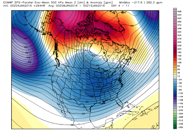
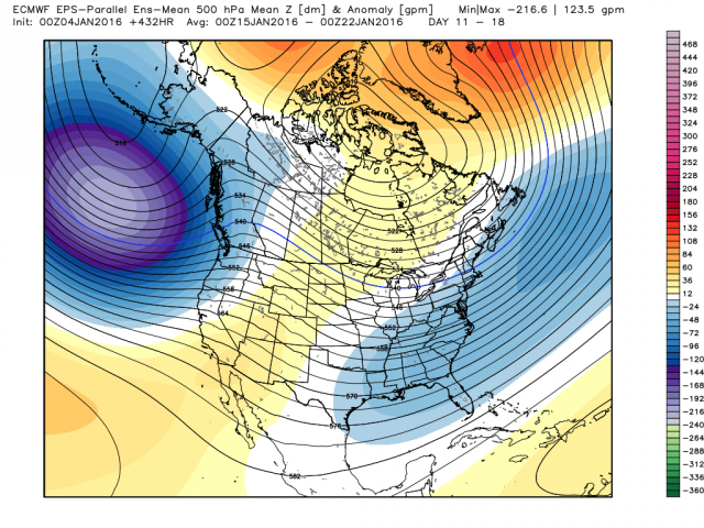
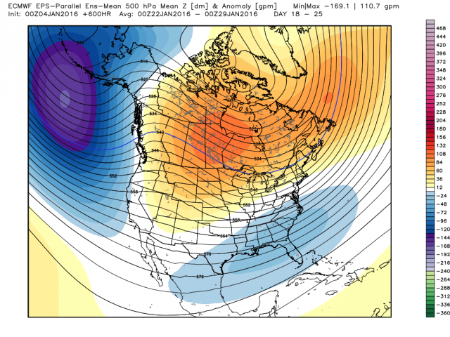
I see a cold pattern with storm chances and a slight relaxation the last week of JAN that goes to normal not above as the weeklies were putting out yesterday. So why is this important because the weeklies got peeps panties all twisted yesterday and saying it was over - the models will and are still correcting from the dark side. It MAY even be better as we move forward when we get a better handle on teh Trop Forcing that is along with teh Strat is going to help drive teh pattern along with their friend MJO
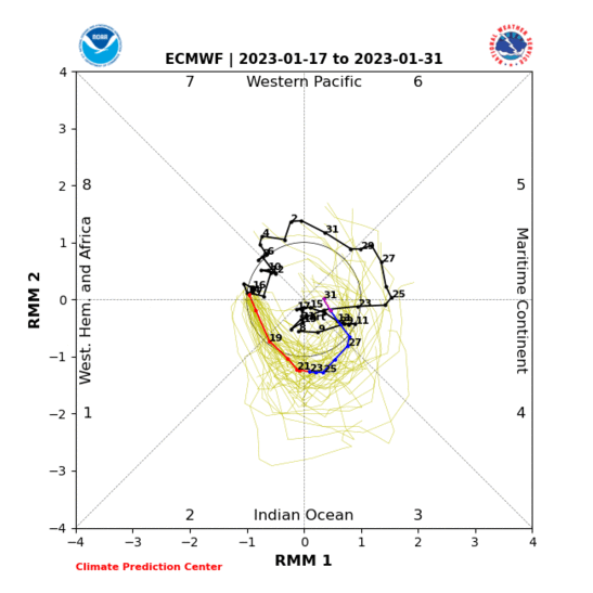


I see a cold pattern with storm chances and a slight relaxation the last week of JAN that goes to normal not above as the weeklies were putting out yesterday. So why is this important because the weeklies got peeps panties all twisted yesterday and saying it was over - the models will and are still correcting from the dark side. It MAY even be better as we move forward when we get a better handle on teh Trop Forcing that is along with teh Strat is going to help drive teh pattern along with their friend MJO

_________________
Mugs
AKA:King: Snow Weenie
Self Proclaimed
WINTER 2014-15 : 55.12" +.02 for 6 coatings (avg. 35")
WINTER 2015-16 Total - 29.8" (Avg 35")
WINTER 2016-17 : 39.5" so far

amugs- Advanced Forecaster - Mod

- Posts : 15157
Reputation : 213
Join date : 2013-01-07
Age : 54
Location : Hillsdale,NJ
 Re: Long Range Thread 9.0
Newest MJO - good sign longer lasting 8,1,2
.gif)
.gif)
_________________
Mugs
AKA:King: Snow Weenie
Self Proclaimed
WINTER 2014-15 : 55.12" +.02 for 6 coatings (avg. 35")
WINTER 2015-16 Total - 29.8" (Avg 35")
WINTER 2016-17 : 39.5" so far

amugs- Advanced Forecaster - Mod

- Posts : 15157
Reputation : 213
Join date : 2013-01-07
Age : 54
Location : Hillsdale,NJ
 Re: Long Range Thread 9.0
Mugs that's a good sign if the convection stays near the Date Line as forecast the MJO should respond by staying in 81 and 2. Also Bernie Rayno has a nice video this morning that everyone should check out on the AccuWeather site. can't post the link right now I'm on my phone I'll try and do it later today. He basically says there's a ton of energy cutting underneath the trough that will set up along the East Coast next week and while models do not show anything at the moment it could get interesting

algae888- Advanced Forecaster

- Posts : 5311
Reputation : 46
Join date : 2013-02-05
Age : 62
Location : mt. vernon, new york
 Re: Long Range Thread 9.0
Yes that i sthe idea with the PV lobe setting up W of Hudson bay we'll have Northern vorts rotate around that bad boy like last year and with an active STJ we have POTENTIAL for multiple storm chances of Miller B's and even A just by teh STJ itself. just need the PNA to hold positive for us to get these to ride the coast. Med range is when I think the models see these not LR sorry fantasy dwellers.algae888 wrote:Mugs that's a good sign if the convection stays near the Date Line as forecast the MJO should respond by staying in 81 and 2. Also Bernie Rayno has a nice video this morning that everyone should check out on the AccuWeather site. can't post the link right now I'm on my phone I'll try and do it later today. He basically says there's a ton of energy cutting underneath the trough that will set up along the East Coast next week and while models do not show anything at the moment it could get interesting
_________________
Mugs
AKA:King: Snow Weenie
Self Proclaimed
WINTER 2014-15 : 55.12" +.02 for 6 coatings (avg. 35")
WINTER 2015-16 Total - 29.8" (Avg 35")
WINTER 2016-17 : 39.5" so far

amugs- Advanced Forecaster - Mod

- Posts : 15157
Reputation : 213
Join date : 2013-01-07
Age : 54
Location : Hillsdale,NJ
 Re: Long Range Thread 9.0
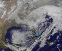
CMC showing a little hope with storm 2 but the problem remains they're too close together, if it bombs out we could see a rain to snow scenario at best with a bigger hit for New England. My thinking ATM.
http://meteocentre.com/models/explorateur.php?mod=gemglb&run=12&stn=PNMPR&hh=144&map=na&stn2=PT&run2=12&mod2=gemglb&hh2=144&comp=1&fixhh=1&lang=en&yyyy=latest&mm=latest&dd=latest&mode=latest&stn2_type=prog&date_type=dateo
http://meteocentre.com/models/explorateur.php?mod=gemglb&run=12&stn=PNMPR&hh=144&map=na&stn2=PT&run2=12&mod2=gemglb&hh2=144&comp=1&fixhh=1&lang=en&yyyy=latest&mm=latest&dd=latest&mode=latest&stn2_type=prog&date_type=dateo
NjWeatherGuy- Advanced Forecaster

- Posts : 4100
Reputation : 28
Join date : 2013-01-06
Location : Belle Mead, NJ
 Re: Long Range Thread 9.0
Most of New England looks to get soaked with that setup. Maybe NWJ and the western HV have a shot at snow.

CPcantmeasuresnow- Wx Statistician Guru

- Posts : 7288
Reputation : 230
Join date : 2013-01-07
Age : 103
Location : Eastern Orange County, NY
 Re: Long Range Thread 9.0
The euro parallel mean looks good mid-month. Enough -NAO blocking than what we're seeing for the 10th storm. Could spark something between 15th-19th.


_________________
_______________________________________________________________________________________________________
CLICK HERE to view NJ Strong Snowstorm Classifications
 Re: Long Range Thread 9.0
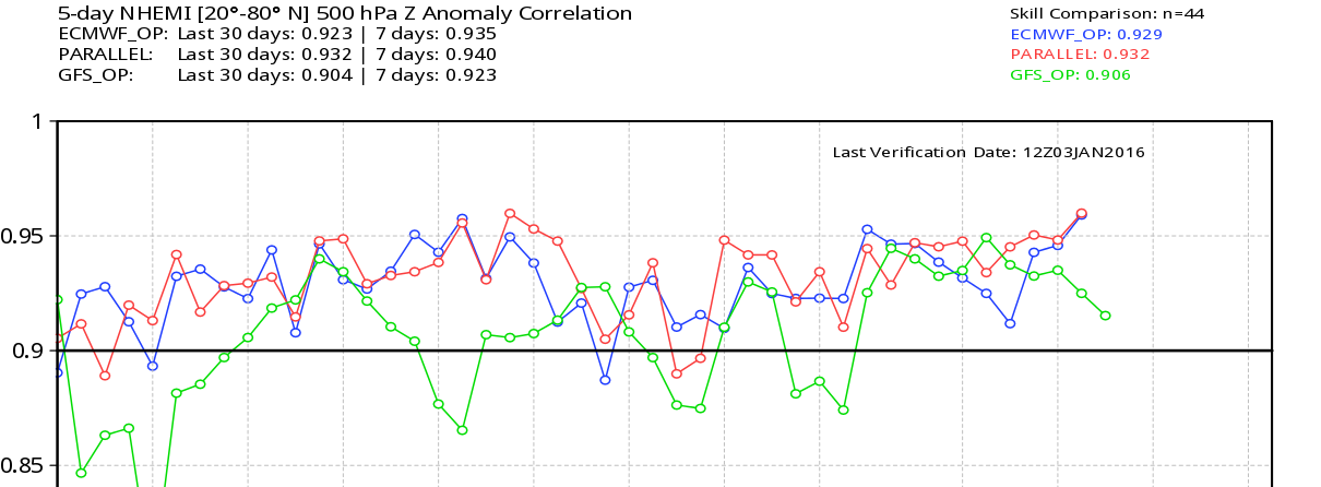
I'm never taking the GFS OP seriously. Horrible stats lately.

_________________
_______________________________________________________________________________________________________
CLICK HERE to view NJ Strong Snowstorm Classifications
 Re: Long Range Thread 9.0
Frank and all what a crap model the GEFS and GFS have been so far this winter with this pattern imo. The GEFS have been playing catch up with this pattern and vastly correction itself mores o than the EPS. The evolution of the pattern with all these moving parts and I made a post in teh otehr forum that the GFS is terrible with the tropics hence why it CAN NOT get the MJO or a handle on it whilst the EURO is far superior with the tropics thus a much greater validation for the MJO.
EURO MJO

GEFS MJO

GEFS Look at the AL Low near rthe WC of BC
.png)
EURO ENS
Not as deep and further west
.png)
CMC
Even colder for the EC
.png)
This is why the GEFS handle of the Aleutian Low is near the West shores of BC where the euro has it more retrograded SW - that is a big difference and again the EURO is picking up on the trop forcing out on the dateline. Also why the GEFS is showing warmer pattern overall for the EC than the EURO or CMC which I learned from my pro met friends sniffs out the cold patterns better (the CMC that is)
Moral of teh story as Frank pointed out don't trust the GFS or GEFS in this EL Nino set up that is basin wide with trop convection out by teh date line. For that we are seeing the possibility of a trop cyclone by French polynesia forming - talking about convection!! This will pull the AL Low further west out towards 150 W SW of teh AL as we head towards the end of this month as per teh Euro Monthlies and Para.
EURO MJO

GEFS MJO

GEFS Look at the AL Low near rthe WC of BC
.png)
EURO ENS
Not as deep and further west
.png)
CMC
Even colder for the EC
.png)
This is why the GEFS handle of the Aleutian Low is near the West shores of BC where the euro has it more retrograded SW - that is a big difference and again the EURO is picking up on the trop forcing out on the dateline. Also why the GEFS is showing warmer pattern overall for the EC than the EURO or CMC which I learned from my pro met friends sniffs out the cold patterns better (the CMC that is)
Moral of teh story as Frank pointed out don't trust the GFS or GEFS in this EL Nino set up that is basin wide with trop convection out by teh date line. For that we are seeing the possibility of a trop cyclone by French polynesia forming - talking about convection!! This will pull the AL Low further west out towards 150 W SW of teh AL as we head towards the end of this month as per teh Euro Monthlies and Para.
_________________
Mugs
AKA:King: Snow Weenie
Self Proclaimed
WINTER 2014-15 : 55.12" +.02 for 6 coatings (avg. 35")
WINTER 2015-16 Total - 29.8" (Avg 35")
WINTER 2016-17 : 39.5" so far

amugs- Advanced Forecaster - Mod

- Posts : 15157
Reputation : 213
Join date : 2013-01-07
Age : 54
Location : Hillsdale,NJ
 Re: Long Range Thread 9.0
I believe euro has a clipper for us Monday night with some light accumulations... nws disco...
THE ECMWF INTRODUCES A CLIPPER MON NGT...PUTTING DOWN SOME
LGT SNOW ACCUMS ACROSS THE CWA. DID LEAN TOWARDS THIS SCENARIO WITH
THE OFFICIAL FCST AND INCLUDED A 30 POP. IF FORM HOLDS...THE GFS
SHOULD BEGIN TO TREND TOWARDS THIS SOLN. OTHERWISE...NO MATTER WHICH
MODEL YOU USE THE PATTERN IS SEASONALLY COLD FOR MON AND TUE
and look at the ao haven't seen those numbers in a long time...


algae888- Advanced Forecaster

- Posts : 5311
Reputation : 46
Join date : 2013-02-05
Age : 62
Location : mt. vernon, new york
 Re: Long Range Thread 9.0
Wow the latest guidance really tanks the AO by mid month. That's usually a precursor of an impending winter storm to track. The models should start to reflect that at the surface by that time. Patience my fellow snow weenies.algae888 wrote:I believe euro has a clipper for us Monday night with some light accumulations... nws disco...
THE ECMWF INTRODUCES A CLIPPER MON NGT...PUTTING DOWN SOME
LGT SNOW ACCUMS ACROSS THE CWA. DID LEAN TOWARDS THIS SCENARIO WITH
THE OFFICIAL FCST AND INCLUDED A 30 POP. IF FORM HOLDS...THE GFS
SHOULD BEGIN TO TREND TOWARDS THIS SOLN. OTHERWISE...NO MATTER WHICH
MODEL YOU USE THE PATTERN IS SEASONALLY COLD FOR MON AND TUE
and look at the ao haven't seen those numbers in a long time...


nutleyblizzard- Senior Enthusiast

- Posts : 1964
Reputation : 41
Join date : 2014-01-30
Age : 58
Location : Nutley, new jersey
 Re: Long Range Thread 9.0
NAO

Looking good

Snow88- Senior Enthusiast

- Posts : 2193
Reputation : 4
Join date : 2013-01-09
Age : 36
Location : Brooklyn, NY
 Re: Long Range Thread 9.0
NAO BOOM Mikey V the GW with call!!
https://twitter.com/MJVentrice/status/684498478584721408?ref_src=twsrc%5Egoogle%7Ctwcamp%5Eserp%7Ctwgr%5Etweet
https://twitter.com/MJVentrice/status/684498478584721408?ref_src=twsrc%5Egoogle%7Ctwcamp%5Eserp%7Ctwgr%5Etweet
_________________
Mugs
AKA:King: Snow Weenie
Self Proclaimed
WINTER 2014-15 : 55.12" +.02 for 6 coatings (avg. 35")
WINTER 2015-16 Total - 29.8" (Avg 35")
WINTER 2016-17 : 39.5" so far

amugs- Advanced Forecaster - Mod

- Posts : 15157
Reputation : 213
Join date : 2013-01-07
Age : 54
Location : Hillsdale,NJ
 Re: Long Range Thread 9.0
MLK Special???
EPS says there is a chance

EPS says there is a chance

_________________
Mugs
AKA:King: Snow Weenie
Self Proclaimed
WINTER 2014-15 : 55.12" +.02 for 6 coatings (avg. 35")
WINTER 2015-16 Total - 29.8" (Avg 35")
WINTER 2016-17 : 39.5" so far

amugs- Advanced Forecaster - Mod

- Posts : 15157
Reputation : 213
Join date : 2013-01-07
Age : 54
Location : Hillsdale,NJ
 Re: Long Range Thread 9.0
Today's 12z gfs is trying to phase the northern and southern jet on Wednesday of next week I'm only out to hour 156. Interesting

algae888- Advanced Forecaster

- Posts : 5311
Reputation : 46
Join date : 2013-02-05
Age : 62
Location : mt. vernon, new york
 Re: Long Range Thread 9.0
GFS just misses of full phase. still gives us some snow for next Wednesday. wow this came out of the clear blue. big difference at 500 millibars from yesterday. Can't post maps I'm on my cell can someone please post when you get a chance

algae888- Advanced Forecaster

- Posts : 5311
Reputation : 46
Join date : 2013-02-05
Age : 62
Location : mt. vernon, new york
 Re: Long Range Thread 9.0
Today's gfs is very different than last nights euro in that the vortex doesn't drop as far south as the Euro showed. So I wouldn't get my hopes up too much for this to happen yet. But it just goes to show that with so much energy flying around the atmosphere it wouldn't take much for a coastal to develop

algae888- Advanced Forecaster

- Posts : 5311
Reputation : 46
Join date : 2013-02-05
Age : 62
Location : mt. vernon, new york
 Re: Long Range Thread 9.0
WOW!#


_________________
Mugs
AKA:King: Snow Weenie
Self Proclaimed
WINTER 2014-15 : 55.12" +.02 for 6 coatings (avg. 35")
WINTER 2015-16 Total - 29.8" (Avg 35")
WINTER 2016-17 : 39.5" so far

amugs- Advanced Forecaster - Mod

- Posts : 15157
Reputation : 213
Join date : 2013-01-07
Age : 54
Location : Hillsdale,NJ
 Re: Long Range Thread 9.0
Watch for the clipper to trend stronger..,.would be a nice starter event for sure.
_________________
"In weather and in life, there's no winning and losing; there's only winning and learning."
WINTER 2012/2013 TOTALS 43.65"WINTER 2017/2018 TOTALS 62.85" WINTER 2022/2023 TOTALS 4.9"
WINTER 2013/2014 TOTALS 64.85"WINTER 2018/2019 TOTALS 14.25" WINTER 2023/2024 TOTALS 13.1"
WINTER 2014/2015 TOTALS 71.20"WINTER 2019/2020 TOTALS 6.35" WINTER 2024/2025 TOTALS 0.00
WINTER 2015/2016 TOTALS 35.00"WINTER 2020/2021 TOTALS 37.75"
WINTER 2016/2017 TOTALS 42.25"WINTER 2021/2022 TOTALS 31.65"

sroc4- Admin

- Posts : 8458
Reputation : 302
Join date : 2013-01-07
Location : Wading River, LI
 Re: Long Range Thread 9.0
It would be nice but I'm not getting to excited long ways off

skinsfan1177- Senior Enthusiast

- Posts : 4485
Reputation : 35
Join date : 2013-01-07
Age : 47
Location : Point Pleasant Boro
 Re: Long Range Thread 9.0
I heard Sunday could break another record high
Abba701- Posts : 328
Reputation : 0
Join date : 2013-01-14
 Re: Long Range Thread 9.0
skinsfan1177 wrote:It would be nice but I'm not getting to excited long ways off
agreed
_________________
"In weather and in life, there's no winning and losing; there's only winning and learning."
WINTER 2012/2013 TOTALS 43.65"WINTER 2017/2018 TOTALS 62.85" WINTER 2022/2023 TOTALS 4.9"
WINTER 2013/2014 TOTALS 64.85"WINTER 2018/2019 TOTALS 14.25" WINTER 2023/2024 TOTALS 13.1"
WINTER 2014/2015 TOTALS 71.20"WINTER 2019/2020 TOTALS 6.35" WINTER 2024/2025 TOTALS 0.00
WINTER 2015/2016 TOTALS 35.00"WINTER 2020/2021 TOTALS 37.75"
WINTER 2016/2017 TOTALS 42.25"WINTER 2021/2022 TOTALS 31.65"

sroc4- Admin

- Posts : 8458
Reputation : 302
Join date : 2013-01-07
Location : Wading River, LI
 Re: Long Range Thread 9.0
Abba701 wrote:I heard Sunday could break another record high
Possibly for NYC. Then we crash as the arctic air settles in.
SROC - even a 1-2" at this point will do reminiscent of last ye at tonic start winter just 1.5 weeks later
_________________
Mugs
AKA:King: Snow Weenie
Self Proclaimed
WINTER 2014-15 : 55.12" +.02 for 6 coatings (avg. 35")
WINTER 2015-16 Total - 29.8" (Avg 35")
WINTER 2016-17 : 39.5" so far

amugs- Advanced Forecaster - Mod

- Posts : 15157
Reputation : 213
Join date : 2013-01-07
Age : 54
Location : Hillsdale,NJ
 Re: Long Range Thread 9.0
Looks like, 13th, 18th and 21st p[ossibilities for storms on 12z GFS. And at the end of the run a beast headed up coast.

jmanley32- Senior Enthusiast

- Posts : 20647
Reputation : 108
Join date : 2013-12-12
Age : 43
Location : Yonkers, NY
Page 5 of 40 •  1, 2, 3, 4, 5, 6 ... 22 ... 40
Page 5 of 40
Permissions in this forum:
You cannot reply to topics in this forum
 Home
Home