Long Range Thread 9.0
+51
Sparky Sparticles
track17
Grselig
snowday111
2004blackwrx
Joe Snow
GreyBeard
devsman
Mathgod55
deadrabbit79
jimv45
Taffy
Biggin23
crippo84
SNOW MAN
lglickman1
Dtone
Artechmetals
Dunnzoo
Vinnydula
Bkdude
SoulSingMG
oldtimer
Quietace
billg315
Math23x7
snow247
jake732
rb924119
Snowfall
Abba701
nutleyblizzard
Radz
RJB8525
justin92
chief7
hyde345
weatherwatchermom
CPcantmeasuresnow
frank 638
HectorO
Snow88
jmanley32
sroc4
skinsfan1177
algae888
amugs
docstox12
Frank_Wx
NjWeatherGuy
dsix85
55 posters
Page 7 of 40
Page 7 of 40 •  1 ... 6, 7, 8 ... 23 ... 40
 Re: Long Range Thread 9.0
frank I am hearing that today's euro splits the pv at 50hpa and 30 hpa and is very disturbed at 10hpa. good sign for a sswe.
algae888- Advanced Forecaster

- Posts : 5311
Join date : 2013-02-05
 Re: Long Range Thread 9.0
lee goldberg was on and he said next wed week from today we will see some snow with some accumulation 

frank 638- Senior Enthusiast

- Posts : 2882
Join date : 2016-01-01
 Re: Long Range Thread 9.0
nws disco...
THERE IS THE POTENTIAL FOR A COASTAL STORM NEXT WED...BUT THERE`S
LOW CONFIDENCE IN THIS DUE TO AFOREMENTIONED TIMING AND AMPLITUDE
DIFFERENCES
THERE IS THE POTENTIAL FOR A COASTAL STORM NEXT WED...BUT THERE`S
LOW CONFIDENCE IN THIS DUE TO AFOREMENTIONED TIMING AND AMPLITUDE
DIFFERENCES

algae888- Advanced Forecaster

- Posts : 5311
Reputation : 46
Join date : 2013-02-05
Age : 62
Location : mt. vernon, new york
 Re: Long Range Thread 9.0
frank 638 wrote:lee goldberg was on and he said next wed week from today we will see some snow with some accumulation

Thats the clipper system. Todays euro was 12 hrs from more than a clipper
_________________
"In weather and in life, there's no winning and losing; there's only winning and learning."
WINTER 2012/2013 TOTALS 43.65"WINTER 2017/2018 TOTALS 62.85" WINTER 2022/2023 TOTALS 4.9"
WINTER 2013/2014 TOTALS 64.85"WINTER 2018/2019 TOTALS 14.25" WINTER 2023/2024 TOTALS 13.1"
WINTER 2014/2015 TOTALS 71.20"WINTER 2019/2020 TOTALS 6.35" WINTER 2024/2025 TOTALS 0.00
WINTER 2015/2016 TOTALS 35.00"WINTER 2020/2021 TOTALS 37.75"
WINTER 2016/2017 TOTALS 42.25"WINTER 2021/2022 TOTALS 31.65"

sroc4- Admin

- Posts : 8458
Reputation : 302
Join date : 2013-01-07
Location : Wading River, LI
 Re: Long Range Thread 9.0
Lots of exciting developments took place over the last 48 hours. I'll have an update between 8-9pm tonight. This includes the Stratosphere.
_________________
_______________________________________________________________________________________________________
CLICK HERE to view NJ Strong Snowstorm Classifications
 Re: Long Range Thread 9.0
Northern energy a little faster, or the southern energy holds back a little, and boom.
[img] [/img]
[img]
 [/img]
_________________
"In weather and in life, there's no winning and losing; there's only winning and learning."
WINTER 2012/2013 TOTALS 43.65"WINTER 2017/2018 TOTALS 62.85" WINTER 2022/2023 TOTALS 4.9"
WINTER 2013/2014 TOTALS 64.85"WINTER 2018/2019 TOTALS 14.25" WINTER 2023/2024 TOTALS 13.1"
WINTER 2014/2015 TOTALS 71.20"WINTER 2019/2020 TOTALS 6.35" WINTER 2024/2025 TOTALS 0.00
WINTER 2015/2016 TOTALS 35.00"WINTER 2020/2021 TOTALS 37.75"
WINTER 2016/2017 TOTALS 42.25"WINTER 2021/2022 TOTALS 31.65"

sroc4- Admin

- Posts : 8458
Reputation : 302
Join date : 2013-01-07
Location : Wading River, LI
 Re: Long Range Thread 9.0
algae888 wrote:frank, scott and rb if the blocking becomes as extreme as the guidance is showing does that mean it becomes harder to break down as we move ahead? and basically we should have blocking for most of the remainder of winter?
Once you get a strong teleconnection into a certain phase, EPO, AO, NAO or whatever, it typically will not simply go away or flip back and disappear. The reason we are seeing the changes in our teleconnection, to an extremely favorable phase, is because major atmospheric changes have been taking place in may parts of the globe, as well as many levels of the atmosphere begining in early Dec, but it has taken to this point to see the influences on our pattern. These changes include, but not limited to the weaking el nino, the MJO, to the stratosphere, the SOI, etc. Therefore no I do not expect a strong neg NAO or neg AO to simply go strong negative and then flip back and stay pos going fowrad. A relaxation and brief changes yes, but in general I expect the meat of the rest of our winter things should remain favorable.
_________________
"In weather and in life, there's no winning and losing; there's only winning and learning."
WINTER 2012/2013 TOTALS 43.65"WINTER 2017/2018 TOTALS 62.85" WINTER 2022/2023 TOTALS 4.9"
WINTER 2013/2014 TOTALS 64.85"WINTER 2018/2019 TOTALS 14.25" WINTER 2023/2024 TOTALS 13.1"
WINTER 2014/2015 TOTALS 71.20"WINTER 2019/2020 TOTALS 6.35" WINTER 2024/2025 TOTALS 0.00
WINTER 2015/2016 TOTALS 35.00"WINTER 2020/2021 TOTALS 37.75"
WINTER 2016/2017 TOTALS 42.25"WINTER 2021/2022 TOTALS 31.65"

sroc4- Admin

- Posts : 8458
Reputation : 302
Join date : 2013-01-07
Location : Wading River, LI
 Re: Long Range Thread 9.0
SROC excellent post in answering Al's question. To add one indicy feeds off the other in the case of the -AO/NAO couplet - the strart will help the AO stay N and this in turn it will help the NAO stay N
Al, Isotherm, said that his feeling is that as he put <1 week we could see the PV split if all goes as is progged. He said it happens faster than one thinks once the domino starts. well. Just like 1957-58 - and umm, does anyone know this analog?
4 storms of 8-18" for the area from storms from late Jan through mid march - again once teh envelope opens for teh stj to comes east we will see miller b from teh lobes of lp that the pv will spin or they cut under round teh base of this bad boy and miller a's. a miller c would be a sick set up in my book.
The NAo block progged is sick and teh ao is looking to tank so bad that it will is forecasted to go off the charts like last years epo looky see
Euro

GEFS

NAO
EURO

GEFS

Starting to catch on but not seeing the feedback on the NAO as well at the euro - many factors and I believe we see them say N maybe greater as we move to teh end of teh month and through Feb
Al, Isotherm, said that his feeling is that as he put <1 week we could see the PV split if all goes as is progged. He said it happens faster than one thinks once the domino starts. well. Just like 1957-58 - and umm, does anyone know this analog?
4 storms of 8-18" for the area from storms from late Jan through mid march - again once teh envelope opens for teh stj to comes east we will see miller b from teh lobes of lp that the pv will spin or they cut under round teh base of this bad boy and miller a's. a miller c would be a sick set up in my book.
The NAo block progged is sick and teh ao is looking to tank so bad that it will is forecasted to go off the charts like last years epo looky see
Euro

GEFS

NAO
EURO

GEFS

Starting to catch on but not seeing the feedback on the NAO as well at the euro - many factors and I believe we see them say N maybe greater as we move to teh end of teh month and through Feb
_________________
Mugs
AKA:King: Snow Weenie
Self Proclaimed
WINTER 2014-15 : 55.12" +.02 for 6 coatings (avg. 35")
WINTER 2015-16 Total - 29.8" (Avg 35")
WINTER 2016-17 : 39.5" so far

amugs- Advanced Forecaster - Mod

- Posts : 15156
Reputation : 213
Join date : 2013-01-07
Age : 54
Location : Hillsdale,NJ
 Re: Long Range Thread 9.0
algae888 wrote:frank, scott and rb if the blocking becomes as extreme as the guidance is showing does that mean it becomes harder to break down as we move ahead? and basically we should have blocking for most of the remainder of winter?
You rannnnnngggggggggg? lmao uh, ok, getting back to business. I can not DEFINITIVELY answer that question, BUT (oh yes, there's a "but")....
It is my understanding that the whole meaning behind a "blocked" pattern is that it is one that becomes stagnated because of some type of forcing(s). Now, I don't mean "stagnant" as in boring and zonal; as the word "blocked" implies, I mean more in the sense of just not being able or allowed to become boring and zonal. The idea behind blocking is that it is a persistent positive feedback loop that essentially (theoretically) continues until something can finally change the perturbation point(s) and re-orient the atmospheric flows. Think of this December; that pattern was blocked. Why? Well, on a sectionalized scale for simplicity's sake, the anomalously deep trough over the western US continued to allow the ridging to keep building into the East. Now there are a plethora of reasons for that, as we all know. But recall how systems kept diving into the western US from Canada following the jet stream. As they would dive, they would intensify (thereby dynamically lowering heights) as they rounded the bend of the trough, which in turn would spike the ridge in the East. This pattern was not broken until we saw several pieces begin to fall apart. One of which was the PV circulation, which started to tank in intensity and opened to easier perturbation, but I think the more important aspect was that we started to see a prolonged series of mildly intense Midwest cutters. As each successive system went by, it slowly started to force the baroclinic zone further east with each storm (which connects to the mid/upper-level patterns). In coordination with the other factors (one of which being the weakened state of the PV), the last cutters forced enough of a perturbation to allow a lobe of the PV to come down, which ultimately allowed the pattern change to begin to re-orient for the better, as we're seeing now. Why did I go through that? Well, with the blocking pattern that you guys are posting about (I honestly haven't looked at anything in the last two days so I have no idea haha blasphemy, I know) I see the exact same scenario unfolding; it should persist until we see constant "pressure" or forcings to act agains the feedback loop. That said, that depends entirely upon how much of the modeling actually comes to pass. The weaker the blocking, the weaker the perturbation(s) needed to disrupt it and reset the pattern as a whole.
On a second note, one of my friends in a much higher place, told me in a friendly conversation about the impending pattern back at the end of December, that once the Stratospheric PV is perturbed and off-kilter, it is remarkably hard to get it to go back to "normal". He's seen that in his research. So, if we can get it over the proverbial ledge, that's it; it's almost a lock that it stays through the winter and into the spring. Similarly, he said it is also remarkably EASY to get it off-kilter, which I think Frank might have hinted at with his post.
As I said, I can't definitively say that is how it will work out, but that's at least my understanding. I'm sure the others will be able to chime in a bit haha I hope that at least made some sense and got the wheels churning a bit.
rb924119- Meteorologist

- Posts : 7112
Reputation : 195
Join date : 2013-02-06
Age : 32
Location : Greentown, Pa
 Re: Long Range Thread 9.0
thanks guys for answering my question. it makes sense what your saying. hopefully this upcoming pattern will last throughout the rest of winter. as cp has said we deserve it with the December we had to endure.lol

algae888- Advanced Forecaster

- Posts : 5311
Reputation : 46
Join date : 2013-02-05
Age : 62
Location : mt. vernon, new york
 Re: Long Range Thread 9.0
Rb,
Great post - let m e ask my boys as well on this if you don't mind me copying this and emailing this info?
Mugs
Great post - let m e ask my boys as well on this if you don't mind me copying this and emailing this info?
Mugs
_________________
Mugs
AKA:King: Snow Weenie
Self Proclaimed
WINTER 2014-15 : 55.12" +.02 for 6 coatings (avg. 35")
WINTER 2015-16 Total - 29.8" (Avg 35")
WINTER 2016-17 : 39.5" so far

amugs- Advanced Forecaster - Mod

- Posts : 15156
Reputation : 213
Join date : 2013-01-07
Age : 54
Location : Hillsdale,NJ
 Re: Long Range Thread 9.0
algae888 wrote:thanks guys for answering my question. it makes sense what your saying. hopefully this upcoming pattern will last throughout the rest of winter. as cp has said we deserve it with the December we had to endure.lol
Big Momma has a way of evening things out as I have said before and will many more times Nature seeks a balance and if one believes in such (Zen) then all will be good.
_________________
Mugs
AKA:King: Snow Weenie
Self Proclaimed
WINTER 2014-15 : 55.12" +.02 for 6 coatings (avg. 35")
WINTER 2015-16 Total - 29.8" (Avg 35")
WINTER 2016-17 : 39.5" so far

amugs- Advanced Forecaster - Mod

- Posts : 15156
Reputation : 213
Join date : 2013-01-07
Age : 54
Location : Hillsdale,NJ
 Re: Long Range Thread 9.0
Can't wait to read your thoughts seems like a lot is going onFrank_Wx wrote:Lots of exciting developments took place over the last 48 hours. I'll have an update between 8-9pm tonight. This includes the Stratosphere.

skinsfan1177- Senior Enthusiast

- Posts : 4485
Reputation : 35
Join date : 2013-01-07
Age : 47
Location : Point Pleasant Boro
 Re: Long Range Thread 9.0
Swiped from anoterh site - these are frickin SOOOO ENCOURAGING!!
.thumb.png.46982b80c0243e66eaea42aba1c8f3f5.png)


If and I stress IF this would be frickin awesome ans I said what Isotherm stated he feels that we could split in <1 weeks time - then the NAO will fall after this due to the start feed back and we have such a tremendous Trop forcing happening out near the dateline 160-180 - don't forget teh MJO going into phase 8 which will help propagate the pattern more favorable. WOW!!
.thumb.png.46982b80c0243e66eaea42aba1c8f3f5.png)


If and I stress IF this would be frickin awesome ans I said what Isotherm stated he feels that we could split in <1 weeks time - then the NAO will fall after this due to the start feed back and we have such a tremendous Trop forcing happening out near the dateline 160-180 - don't forget teh MJO going into phase 8 which will help propagate the pattern more favorable. WOW!!
_________________
Mugs
AKA:King: Snow Weenie
Self Proclaimed
WINTER 2014-15 : 55.12" +.02 for 6 coatings (avg. 35")
WINTER 2015-16 Total - 29.8" (Avg 35")
WINTER 2016-17 : 39.5" so far

amugs- Advanced Forecaster - Mod

- Posts : 15156
Reputation : 213
Join date : 2013-01-07
Age : 54
Location : Hillsdale,NJ
 Re: Long Range Thread 9.0
Isotherm
Splits are typically much more rapid in forcing tropospheric changes, sometimes < 1 week. Displacements a bit longer. If we do achieve a split, it would positively feedback w/ the current blocking cycle, reinforcing more protracted blocking.
Like I said yesterday with the 1958 example - the vortex structure can change quite rapidly, over the course of several days.
This guy can run circles around most mets on this topic and isn't even a pro met !!
PS - he is member here (recruited him last year)I been pming him to post more here!!
_________________
Mugs
AKA:King: Snow Weenie
Self Proclaimed
WINTER 2014-15 : 55.12" +.02 for 6 coatings (avg. 35")
WINTER 2015-16 Total - 29.8" (Avg 35")
WINTER 2016-17 : 39.5" so far

amugs- Advanced Forecaster - Mod

- Posts : 15156
Reputation : 213
Join date : 2013-01-07
Age : 54
Location : Hillsdale,NJ
 Re: Long Range Thread 9.0
I want a full fledge blizzard NYC shut down kinda storm from my mouth to Elsa ears
Snowfall- Posts : 59
Reputation : 0
Join date : 2015-12-31
 Re: Long Range Thread 9.0
Snowfall wrote:I want a full fledge blizzard NYC shut down kinda storm from my mouth to Elsa ears
Having an almost 6yr old daughter this makes me laugh out loud.
_________________
"In weather and in life, there's no winning and losing; there's only winning and learning."
WINTER 2012/2013 TOTALS 43.65"WINTER 2017/2018 TOTALS 62.85" WINTER 2022/2023 TOTALS 4.9"
WINTER 2013/2014 TOTALS 64.85"WINTER 2018/2019 TOTALS 14.25" WINTER 2023/2024 TOTALS 13.1"
WINTER 2014/2015 TOTALS 71.20"WINTER 2019/2020 TOTALS 6.35" WINTER 2024/2025 TOTALS 0.00
WINTER 2015/2016 TOTALS 35.00"WINTER 2020/2021 TOTALS 37.75"
WINTER 2016/2017 TOTALS 42.25"WINTER 2021/2022 TOTALS 31.65"

sroc4- Admin

- Posts : 8458
Reputation : 302
Join date : 2013-01-07
Location : Wading River, LI
 Re: Long Range Thread 9.0
excellent write up and map you posted amugs should we start looking for our snow shovels and snowblowers ready
frank 638- Senior Enthusiast

- Posts : 2882
Reputation : 37
Join date : 2016-01-01
Age : 41
Location : bronx ny
 Re: Long Range Thread 9.0
I posted a blog. Sorry for the delay.
_________________
_______________________________________________________________________________________________________
CLICK HERE to view NJ Strong Snowstorm Classifications
 Re: Long Range Thread 9.0
GEPS ON BOARD - just thought I add to this discussion from the model that sniffed out the first arctic blast

COME TO POPPA - LOOK AT THIS BLOCK - IF we get this then .............


COME TO POPPA - LOOK AT THIS BLOCK - IF we get this then .............

_________________
Mugs
AKA:King: Snow Weenie
Self Proclaimed
WINTER 2014-15 : 55.12" +.02 for 6 coatings (avg. 35")
WINTER 2015-16 Total - 29.8" (Avg 35")
WINTER 2016-17 : 39.5" so far

amugs- Advanced Forecaster - Mod

- Posts : 15156
Reputation : 213
Join date : 2013-01-07
Age : 54
Location : Hillsdale,NJ
 Re: Long Range Thread 9.0
Chief7 made mention a few days ago about CANSIPS that JB uses - Iposted such maps last month about what it saw upcoming and the Canadians are dead on - lets look at what they say now:
JAN

FEB

March

From PB opn 2 m temp for FEB - COLD BRRRRRRRRR!!

-2 to 3 BN -
JAN

FEB

March

From PB opn 2 m temp for FEB - COLD BRRRRRRRRR!!

-2 to 3 BN -
_________________
Mugs
AKA:King: Snow Weenie
Self Proclaimed
WINTER 2014-15 : 55.12" +.02 for 6 coatings (avg. 35")
WINTER 2015-16 Total - 29.8" (Avg 35")
WINTER 2016-17 : 39.5" so far

amugs- Advanced Forecaster - Mod

- Posts : 15156
Reputation : 213
Join date : 2013-01-07
Age : 54
Location : Hillsdale,NJ
 Re: Long Range Thread 9.0
0z GFS is a lot closer with the redeveloping clipper due to the vort being strong.

Snow88- Senior Enthusiast

- Posts : 2193
Reputation : 4
Join date : 2013-01-09
Age : 36
Location : Brooklyn, NY
 Re: Long Range Thread 9.0
The 13th has clipper written all over it. We want that clipper to deepen as much as possible to enhance the -NAO block and set us up for the bigger storm week of the 16th
_________________
_______________________________________________________________________________________________________
CLICK HERE to view NJ Strong Snowstorm Classifications
 Re: Long Range Thread 9.0
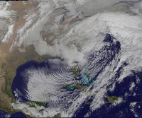
This run brought it further south and redeveloping a bit, previously its shown going through NYS and giving us little to no precip. Track continuing to trend and south would obviously be better for us with a reformation off NJ.
NjWeatherGuy- Advanced Forecaster

- Posts : 4100
Reputation : 28
Join date : 2013-01-06
Location : Belle Mead, NJ
 Re: Long Range Thread 9.0
amugs wrote:Rb,
Great post - let m e ask my boys as well on this if you don't mind me copying this and emailing this info?
Mugs
Go for it my man!
rb924119- Meteorologist

- Posts : 7112
Reputation : 195
Join date : 2013-02-06
Age : 32
Location : Greentown, Pa
 Re: Long Range Thread 9.0
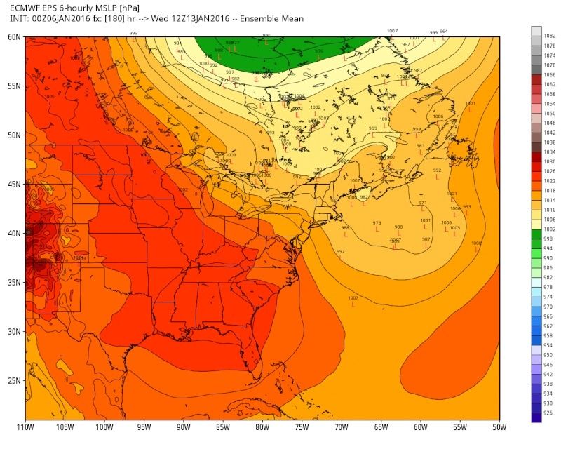
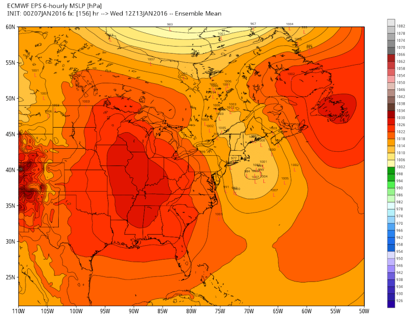
EPS update on the clipper for next wed. Keep in mind what this system does (position and strength) after it moves NE plays a role in the time frame after. All images are valid for 12z Jan 13th.
00z Jan 5th run the EPS went from this:

 " />
" />
00z Jan 6th To this:

 " />
" />
And this was last nights 00z:

 " />
" />
Trends have been decent with this thus far. In addition to the LP off the NE coast is evolving also pay attention to how the HP to the west and NE is developing. Obviously eastern sections probably stand to benefit most with this potential, but obviously nothing is off the table at this point.
00z Jan 5th run the EPS went from this:
 " />
" />00z Jan 6th To this:
 " />
" />And this was last nights 00z:
 " />
" />Trends have been decent with this thus far. In addition to the LP off the NE coast is evolving also pay attention to how the HP to the west and NE is developing. Obviously eastern sections probably stand to benefit most with this potential, but obviously nothing is off the table at this point.
_________________
"In weather and in life, there's no winning and losing; there's only winning and learning."
WINTER 2012/2013 TOTALS 43.65"WINTER 2017/2018 TOTALS 62.85" WINTER 2022/2023 TOTALS 4.9"
WINTER 2013/2014 TOTALS 64.85"WINTER 2018/2019 TOTALS 14.25" WINTER 2023/2024 TOTALS 13.1"
WINTER 2014/2015 TOTALS 71.20"WINTER 2019/2020 TOTALS 6.35" WINTER 2024/2025 TOTALS 0.00
WINTER 2015/2016 TOTALS 35.00"WINTER 2020/2021 TOTALS 37.75"
WINTER 2016/2017 TOTALS 42.25"WINTER 2021/2022 TOTALS 31.65"

sroc4- Admin

- Posts : 8458
Reputation : 302
Join date : 2013-01-07
Location : Wading River, LI
 Re: Long Range Thread 9.0
sroc4 wrote:EPS update on the clipper for next wed. Keep in mind what this system does (position and strength) after it moves NE plays a role in the time frame after. All images are valid for 12z Jan 13th.
00z Jan 5th run the EPS went from this:" />
00z Jan 6th To this:" />
And this was last nights 00z:" />
Trends have been decent with this thus far. In addition to the LP off the NE coast is evolving also pay attention to how the HP to the west and NE is developing. Obviously eastern sections probably stand to benefit most with this potential, but obviously nothing is off the table at this point.
Give me some odds here sroc. The last frame looks good to me. Are we looking at a quick-hitting 2-4" to maybe lay the foundation, or too early?
Guest- Guest
Page 7 of 40 •  1 ... 6, 7, 8 ... 23 ... 40
Page 7 of 40
Permissions in this forum:
You cannot reply to topics in this forum
 Home
Home