Long Range Thread 9.0
+51
Sparky Sparticles
track17
Grselig
snowday111
2004blackwrx
Joe Snow
GreyBeard
devsman
Mathgod55
deadrabbit79
jimv45
Taffy
Biggin23
crippo84
SNOW MAN
lglickman1
Dtone
Artechmetals
Dunnzoo
Vinnydula
Bkdude
SoulSingMG
oldtimer
Quietace
billg315
Math23x7
snow247
jake732
rb924119
Snowfall
Abba701
nutleyblizzard
Radz
RJB8525
justin92
chief7
hyde345
weatherwatchermom
CPcantmeasuresnow
frank 638
HectorO
Snow88
jmanley32
sroc4
skinsfan1177
algae888
amugs
docstox12
Frank_Wx
NjWeatherGuy
dsix85
55 posters
Page 8 of 40
Page 8 of 40 •  1 ... 5 ... 7, 8, 9 ... 24 ... 40
 Re: Long Range Thread 9.0
EPS update on the clipper for next wed. Keep in mind what this system does (position and strength) after it moves NE plays a role in the time frame after. All images are valid for 12z Jan 13th.
00z Jan 5th run the EPS went from this:

 " />
" />
00z Jan 6th To this:

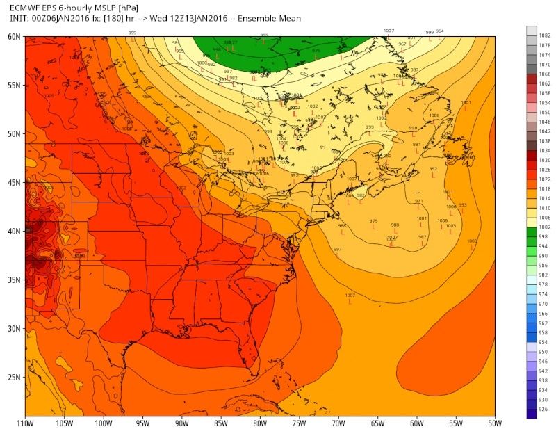 " />
" />
And this was last nights 00z:

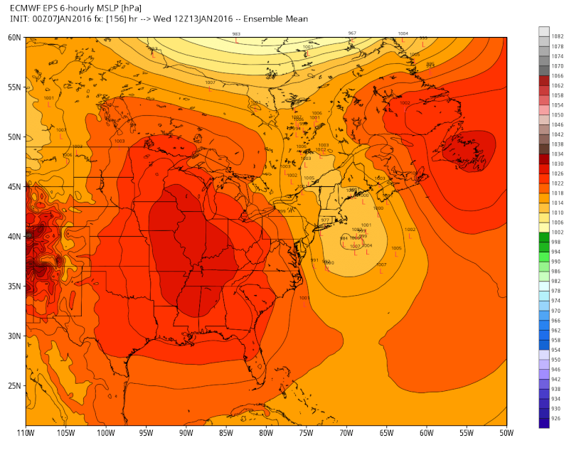 " />
" />
Trends have been decent with this thus far. In addition to the LP off the NE coast is evolving also pay attention to how the HP to the west and NE is developing. Obviously eastern sections probably stand to benefit most with this potential, but obviously nothing is off the table at this point.
00z Jan 5th run the EPS went from this:
 " />
" />00z Jan 6th To this:
 " />
" />And this was last nights 00z:
 " />
" />Trends have been decent with this thus far. In addition to the LP off the NE coast is evolving also pay attention to how the HP to the west and NE is developing. Obviously eastern sections probably stand to benefit most with this potential, but obviously nothing is off the table at this point.
sroc4- Admin

- Posts : 8458
Join date : 2013-01-07
 Re: Long Range Thread 9.0
sroc4 wrote:EPS update on the clipper for next wed. Keep in mind what this system does (position and strength) after it moves NE plays a role in the time frame after. All images are valid for 12z Jan 13th.
00z Jan 5th run the EPS went from this:" />
00z Jan 6th To this:" />
And this was last nights 00z:" />
Trends have been decent with this thus far. In addition to the LP off the NE coast is evolving also pay attention to how the HP to the west and NE is developing. Obviously eastern sections probably stand to benefit most with this potential, but obviously nothing is off the table at this point.
Give me some odds here sroc. The last frame looks good to me. Are we looking at a quick-hitting 2-4" to maybe lay the foundation, or too early?
Guest- Guest
 Re: Long Range Thread 9.0
That's exactly what Im hoping for here James. Im not quite ready to give odds though. I should point out the GFS overnight trended somewhat favorably and the Euro trended a tad deeper with its northern energy compared to the image I posted yesterday.
Yesterday 12z Euro Op:
[img] [/img]
Last night 00z
[img] [/img]
All good things. The energy associated with this still is out in the NE Pac. It will end up over the arctic/N Canada before diving in, so sampling is still relatively limited so additional changes are to be expected for better or worse. I will be more confident in what will happen as we head into the weekend.
Yesterday 12z Euro Op:
[img]
 [/img]
Last night 00z
[img]
 [/img]
All good things. The energy associated with this still is out in the NE Pac. It will end up over the arctic/N Canada before diving in, so sampling is still relatively limited so additional changes are to be expected for better or worse. I will be more confident in what will happen as we head into the weekend.
_________________
"In weather and in life, there's no winning and losing; there's only winning and learning."
WINTER 2012/2013 TOTALS 43.65"WINTER 2017/2018 TOTALS 62.85" WINTER 2022/2023 TOTALS 4.9"
WINTER 2013/2014 TOTALS 64.85"WINTER 2018/2019 TOTALS 14.25" WINTER 2023/2024 TOTALS 13.1"
WINTER 2014/2015 TOTALS 71.20"WINTER 2019/2020 TOTALS 6.35" WINTER 2024/2025 TOTALS 0.00
WINTER 2015/2016 TOTALS 35.00"WINTER 2020/2021 TOTALS 37.75"
WINTER 2016/2017 TOTALS 42.25"WINTER 2021/2022 TOTALS 31.65"

sroc4- Admin

- Posts : 8458
Reputation : 302
Join date : 2013-01-07
Location : Wading River, LI
 Re: Long Range Thread 9.0
nice stuff scott frank rb and mugs. things are looking up. hopefully we can get the right timing now. here is steve d take on next week...
"Now, going forward, the short wave energy that will be diving towards the Northern Mid Atlantic (wens) will be capable of slowing down and developing over the very warm coastal waters. The pattern is developing such that a powerful thermal gradient will be present on the coastal plain to drive rapid low pressure intensification that the models likely are not going to be able to show very well. This is why I am rather concerned about the potential for a surprise snowfall on Wednesday morning as a clipper dives towards the coast. These types of low pressure systems have the potential to produce a surprise heavy snowfall if the low pressure system develops close enough to the coast and fast enough before exiting.
Beyond that, there is a ton of potential with plenty of energy from the Sub Tropical and Polar jet streams. It’s just a matter of timing. I do believe the potential for a major east coast snow storm is increasing exponentially towards January 17th.

algae888- Advanced Forecaster

- Posts : 5311
Reputation : 46
Join date : 2013-02-05
Age : 62
Location : mt. vernon, new york
 Re: Long Range Thread 9.0
Go back to my post from yesterday afternoon. Even though I'm not a fan of the GFS, especially in the long range the threat around the 17th and 18th looks too good to be true. A 2 day nor-easter with plenty of cold air. Frank just a couple of days ago posted this same threat in the banter section. Now we're 10 days out so give me 5 more days and if the signal is still there I'll start getting fired up.
I NEED SOME WHITE!!!!!

 It's just freakin time for some.
........and right after I post this I look at the 0z run of the GFS and see the 18th system is now shown to be a cutter from Georgia to Buffalo, and the next threat after that cuts into Chicago. This is why I hate to look at the long-range!!!


I NEED SOME WHITE!!!!!
........and right after I post this I look at the 0z run of the GFS and see the 18th system is now shown to be a cutter from Georgia to Buffalo, and the next threat after that cuts into Chicago. This is why I hate to look at the long-range!!!
Guest- Guest
 Re: Long Range Thread 9.0
The 12z GFS OP still shows a -NAO block. My only concern is we lose the +PNA and the northern and southern stream energies have no mechanism of phasing together. We really need the Aleutian trough to stay as far west as possible and not track toward the west coast. As long as the forcing remains over the International Dateline we should be able to get a +PNA.
_________________
_______________________________________________________________________________________________________
CLICK HERE to view NJ Strong Snowstorm Classifications
 Re: Long Range Thread 9.0
The Canadian really bombs the system on Wednesday however a little too far east. does give Long Island some decent snows and has snow for most of the area albeit lite. GFS is flatter and about a day later. Let's see what the ensembles look like as the operation will flip back and forth for the next several days

algae888- Advanced Forecaster

- Posts : 5311
Reputation : 46
Join date : 2013-02-05
Age : 62
Location : mt. vernon, new york
 Re: Long Range Thread 9.0
I'm also hearing the UKIE has the storm near the benchmark at hour 144. I don't have access to it so I'm not sure if that's true.
Edit: forget that they were talking about the Canadian
Edit: forget that they were talking about the Canadian

algae888- Advanced Forecaster

- Posts : 5311
Reputation : 46
Join date : 2013-02-05
Age : 62
Location : mt. vernon, new york
 Re: Long Range Thread 9.0
Only going to say this once: LATEST MJO OUTLOOKS SHOW LARGE CONSENSUS THAT 1. IT WILL REMAIN AMPLIFIED THROUGH PHASES 8 AND 1; 2. IT WILL NOT MAKE IT BEYOND PHASE 2 OUTSIDE THE C.O.D. AND APPEARS TO BEGIN RECURVING TOWARDS PHASE 8 AT THE ENDS OF MOST RUNS (ENSEMBLES INCLUDED). As a result of this, I would tend to throw away the GFS' idea of a further east Aleutian Low and watch for it to correct itself as time goes on.
It also appears another (I think it will be four now) burst of fluxes entering the Stratosphere beginning around January 12th or so. Someone throw water on me because I MUST be dreaming....
I think we see the GFS Ensembles continue to correct to looks similar to this as we get closer to the lagged "Long Range".....

rb924119- Meteorologist

- Posts : 7112
Reputation : 195
Join date : 2013-02-06
Age : 32
Location : Greentown, Pa
 Re: Long Range Thread 9.0
bernie rayno in his most recent video says that for ny nj next week there really isnt a shot for snow its more for boston and north! darn is all i can say!! finally we have it set up with the cold and here comes the storm but NO its gonna go north. 


 Re: Long Range Thread 9.0
algae888 wrote:The Canadian really bombs the system on Wednesday however a little too far east. does give Long Island some decent snows and has snow for most of the area albeit lite. GFS is flatter and about a day later. Let's see what the ensembles look like as the operation will flip back and forth for the next several days
You can really see the GFS's progressive bias in the southern stream with this run. I bet Euro looks similar to CMC. CMC also gives a look like an inverted trough wants to form too.

_________________
"In weather and in life, there's no winning and losing; there's only winning and learning."
WINTER 2012/2013 TOTALS 43.65"WINTER 2017/2018 TOTALS 62.85" WINTER 2022/2023 TOTALS 4.9"
WINTER 2013/2014 TOTALS 64.85"WINTER 2018/2019 TOTALS 14.25" WINTER 2023/2024 TOTALS 13.1"
WINTER 2014/2015 TOTALS 71.20"WINTER 2019/2020 TOTALS 6.35" WINTER 2024/2025 TOTALS 0.00
WINTER 2015/2016 TOTALS 35.00"WINTER 2020/2021 TOTALS 37.75"
WINTER 2016/2017 TOTALS 42.25"WINTER 2021/2022 TOTALS 31.65"

sroc4- Admin

- Posts : 8458
Reputation : 302
Join date : 2013-01-07
Location : Wading River, LI
 Re: Long Range Thread 9.0
sroc4 wrote:algae888 wrote:The Canadian really bombs the system on Wednesday however a little too far east. does give Long Island some decent snows and has snow for most of the area albeit lite. GFS is flatter and about a day later. Let's see what the ensembles look like as the operation will flip back and forth for the next several days
You can really see the GFS's progressive bias in the southern stream with this run. I bet Euro looks similar to CMC. CMC also gives a look like an inverted trough wants to form too.
GFS vs here is the CMC clearly digs the N vort in deeper and holds back the S energy relative to the GFS.

_________________
"In weather and in life, there's no winning and losing; there's only winning and learning."
WINTER 2012/2013 TOTALS 43.65"WINTER 2017/2018 TOTALS 62.85" WINTER 2022/2023 TOTALS 4.9"
WINTER 2013/2014 TOTALS 64.85"WINTER 2018/2019 TOTALS 14.25" WINTER 2023/2024 TOTALS 13.1"
WINTER 2014/2015 TOTALS 71.20"WINTER 2019/2020 TOTALS 6.35" WINTER 2024/2025 TOTALS 0.00
WINTER 2015/2016 TOTALS 35.00"WINTER 2020/2021 TOTALS 37.75"
WINTER 2016/2017 TOTALS 42.25"WINTER 2021/2022 TOTALS 31.65"

sroc4- Admin

- Posts : 8458
Reputation : 302
Join date : 2013-01-07
Location : Wading River, LI
 Re: Long Range Thread 9.0
you are correct scott the euro at 120hrs looks like the cmc... even a little further west


Last edited by algae888 on Thu Jan 07, 2016 1:33 pm; edited 1 time in total

algae888- Advanced Forecaster

- Posts : 5311
Reputation : 46
Join date : 2013-02-05
Age : 62
Location : mt. vernon, new york
 Re: Long Range Thread 9.0
Just saw the Rayno video too. I like him. He's pretty confident we get shut out of snow from Boston on south. 


Guest- Guest
 Re: Long Range Thread 9.0
I'll stick eat Hong the guys on here!

skinsfan1177- Senior Enthusiast

- Posts : 4485
Reputation : 35
Join date : 2013-01-07
Age : 47
Location : Point Pleasant Boro
 Re: Long Range Thread 9.0
skinsfan1177 wrote:I'll stick eat Hong the guys on here!
LOL..I think I know what your trying to say.
_________________
"In weather and in life, there's no winning and losing; there's only winning and learning."
WINTER 2012/2013 TOTALS 43.65"WINTER 2017/2018 TOTALS 62.85" WINTER 2022/2023 TOTALS 4.9"
WINTER 2013/2014 TOTALS 64.85"WINTER 2018/2019 TOTALS 14.25" WINTER 2023/2024 TOTALS 13.1"
WINTER 2014/2015 TOTALS 71.20"WINTER 2019/2020 TOTALS 6.35" WINTER 2024/2025 TOTALS 0.00
WINTER 2015/2016 TOTALS 35.00"WINTER 2020/2021 TOTALS 37.75"
WINTER 2016/2017 TOTALS 42.25"WINTER 2021/2022 TOTALS 31.65"

sroc4- Admin

- Posts : 8458
Reputation : 302
Join date : 2013-01-07
Location : Wading River, LI
 Re: Long Range Thread 9.0
The reason why Bernie says we probably get shut out is because the GFS is flattening the flow to our west so the northern stream energy does not dig into our area. We're in between the polar jet and southern jet with little to no activity. That said, the GEFS have better height rise than the GFS OP. The GFS OP has been TERRIBLE lately.


_________________
_______________________________________________________________________________________________________
CLICK HERE to view NJ Strong Snowstorm Classifications
 Re: Long Range Thread 9.0
Cant help but post this 12z GFS Miller B beauty tease at the end of the run. Pure eye candy but possible with that timeframe becoming a transition pattern with a lot of GOM moisture showing up on models. How I wish.
Surface freezing line.
http://mag.ncep.noaa.gov/Image.php?fhr=384&image=data%2Fgfs%2F12%2Fgfs_namer_384_10m_wnd_precip.gif&model=gfs&area=namer¶m=10m_wnd_precip&group=Model+Guidance&preselected_formatted_cycle_date=20160107+12+UTC&imageSize=M&ps=model
Surface freezing line.
http://mag.ncep.noaa.gov/Image.php?fhr=384&image=data%2Fgfs%2F12%2Fgfs_namer_384_10m_wnd_precip.gif&model=gfs&area=namer¶m=10m_wnd_precip&group=Model+Guidance&preselected_formatted_cycle_date=20160107+12+UTC&imageSize=M&ps=model
NjWeatherGuy- Advanced Forecaster

- Posts : 4100
Reputation : 28
Join date : 2013-01-06
Location : Belle Mead, NJ
 Re: Long Range Thread 9.0
Frank_Wx wrote:The reason why Bernie says we probably get shut out is because the GFS is flattening the flow to our west so the northern stream energy does not dig into our area. We're in between the polar jet and southern jet with little to no activity. That said, the GEFS have better height rise than the GFS OP. The GFS OP has been TERRIBLE lately.
Yeah kind of. He says the northern stream trof goes neutral but a little too late and too far north for areas south of Boston. He says it could still trend slower and more sw but he's not enthused.
Guest- Guest
 Re: Long Range Thread 9.0
From TJAY another Met:
blocky patterns are good patterns... if you think about the landscape of what that is... from a 500 mb perspective, it's many closed features positioned in various locations... and blockiness promotes other blockiness... if you think about how you want to get a mature, mid latitude east coast cyclone... it's all about slowing down progression... allowing for energy to promote negatively tilted trofs to help create lower pressures at the surface.. a relaxation at the right time allows for the evolution of good cyclogenesis and a relaxation allows for the progression up to our area. it is simply hard to create nice, mature, closed 500 mb lows in a progressive pattern, without some blocky feature to help ensure it closes off...
Speaking of a block - WOW!!
Last edited by amugs on Thu Jan 07, 2016 2:05 pm; edited 1 time in total
_________________
Mugs
AKA:King: Snow Weenie
Self Proclaimed
WINTER 2014-15 : 55.12" +.02 for 6 coatings (avg. 35")
WINTER 2015-16 Total - 29.8" (Avg 35")
WINTER 2016-17 : 39.5" so far

amugs- Advanced Forecaster - Mod

- Posts : 15157
Reputation : 213
Join date : 2013-01-07
Age : 54
Location : Hillsdale,NJ
 Re: Long Range Thread 9.0
syosnow94 wrote:Frank_Wx wrote:The reason why Bernie says we probably get shut out is because the GFS is flattening the flow to our west so the northern stream energy does not dig into our area. We're in between the polar jet and southern jet with little to no activity. That said, the GEFS have better height rise than the GFS OP. The GFS OP has been TERRIBLE lately.
Yeah kind of. He says the northern stream trof goes neutral but a little too late and too far north for areas south of Boston. He says it could still trend slower and more sw but he's not enthused.
Right now given the models verbatim Id have to agree with that conclusion.
_________________
"In weather and in life, there's no winning and losing; there's only winning and learning."
WINTER 2012/2013 TOTALS 43.65"WINTER 2017/2018 TOTALS 62.85" WINTER 2022/2023 TOTALS 4.9"
WINTER 2013/2014 TOTALS 64.85"WINTER 2018/2019 TOTALS 14.25" WINTER 2023/2024 TOTALS 13.1"
WINTER 2014/2015 TOTALS 71.20"WINTER 2019/2020 TOTALS 6.35" WINTER 2024/2025 TOTALS 0.00
WINTER 2015/2016 TOTALS 35.00"WINTER 2020/2021 TOTALS 37.75"
WINTER 2016/2017 TOTALS 42.25"WINTER 2021/2022 TOTALS 31.65"

sroc4- Admin

- Posts : 8458
Reputation : 302
Join date : 2013-01-07
Location : Wading River, LI
 Re: Long Range Thread 9.0
rb924119 wrote:Only going to say this once: LATEST MJO OUTLOOKS SHOW LARGE CONSENSUS THAT 1. IT WILL REMAIN AMPLIFIED THROUGH PHASES 8 AND 1; 2. IT WILL NOT MAKE IT BEYOND PHASE 2 OUTSIDE THE C.O.D. AND APPEARS TO BEGIN RECURVING TOWARDS PHASE 8 AT THE ENDS OF MOST RUNS (ENSEMBLES INCLUDED). As a result of this, I would tend to throw away the GFS' idea of a further east Aleutian Low and watch for it to correct itself as time goes on.
It also appears another (I think it will be four now) burst of fluxes entering the Stratosphere beginning around January 12th or so. Someone throw water on me because I MUST be dreaming....
I think we see the GFS Ensembles continue to correct to looks similar to this as we get closer to the lagged "Long Range".....

Rb,
As I have stated on this forum ad naseum - maybe 1000x that one the GFS blows chunks, two the Tropical forcing is going to take over teh pattern so to speak with teh Strat breaking (I am hopefully of) or elongating teh PV which will (both) have feedback on our pattern - trop forcing tugging everything west - hence retrograding teh AL Vortext of death and two teh AO goes N which will in this case promote the NAO to go N. The pattern is setting up and the models - GFS and it ENS will play catch up until March for crying all night - the CMC (GEPS) sniffed out the cold pattern and the Euro seasonal/monthlies showed us back in late Aug what teh pattern would be - retrograded LP to 150W above Hawaii (well SW of Aleutians) and dateline Tstorms known as forcing - Siberian snow pack IMO has done its job for our Strat so far and the NAO - ROCKY FTW!!! (My chia pet - my how we have short term memory!)
Also, how this storm goes this weekend will ALSO help set up our pattern going forward lets not forget that.
_________________
Mugs
AKA:King: Snow Weenie
Self Proclaimed
WINTER 2014-15 : 55.12" +.02 for 6 coatings (avg. 35")
WINTER 2015-16 Total - 29.8" (Avg 35")
WINTER 2016-17 : 39.5" so far

amugs- Advanced Forecaster - Mod

- Posts : 15157
Reputation : 213
Join date : 2013-01-07
Age : 54
Location : Hillsdale,NJ
 Re: Long Range Thread 9.0
This just in from Earthlight: WOW!!
Both the Euro and the GFS agree (OP and Ensembles) that we are going to enter a period of incredible high latitude blocking from Greenland through the Arctic Cricle to the EPO region. In fact, the positioning of the H5 trough by the Euro from N Maine to the 50/50 position argues that this storm system late Day 8-10 should take a track farther east and nearer to the coast. That being said, it's not worth getting caught up in those specifics.
Here's the takeaway right now: Increasing consensus in incredible high latitude blocking with lots of subtropical jet influence and plenty of opportunities with support from the Pac and Atl side.The nuances (W Coast ridge positioning, 50/50 positioning, individual vorts, etc) we cannot possibly figure out at this time.
IF these medium range models are correct with the blocking being modeled, we will be playing in the big leagues here over the next few weeks. Some of the most prolific East Coast winter storms have occurred with these types of setups.

The talk keeps getting better and better with each model run is how I see it
Both the Euro and the GFS agree (OP and Ensembles) that we are going to enter a period of incredible high latitude blocking from Greenland through the Arctic Cricle to the EPO region. In fact, the positioning of the H5 trough by the Euro from N Maine to the 50/50 position argues that this storm system late Day 8-10 should take a track farther east and nearer to the coast. That being said, it's not worth getting caught up in those specifics.
Here's the takeaway right now: Increasing consensus in incredible high latitude blocking with lots of subtropical jet influence and plenty of opportunities with support from the Pac and Atl side.The nuances (W Coast ridge positioning, 50/50 positioning, individual vorts, etc) we cannot possibly figure out at this time.
IF these medium range models are correct with the blocking being modeled, we will be playing in the big leagues here over the next few weeks. Some of the most prolific East Coast winter storms have occurred with these types of setups.

The talk keeps getting better and better with each model run is how I see it
_________________
Mugs
AKA:King: Snow Weenie
Self Proclaimed
WINTER 2014-15 : 55.12" +.02 for 6 coatings (avg. 35")
WINTER 2015-16 Total - 29.8" (Avg 35")
WINTER 2016-17 : 39.5" so far

amugs- Advanced Forecaster - Mod

- Posts : 15157
Reputation : 213
Join date : 2013-01-07
Age : 54
Location : Hillsdale,NJ
 Re: Long Range Thread 9.0
skinsfan1177 wrote:I'll stick eat Hong the guys on here!
Skins, I think this is on the wrong thread. I'm not really sure if we have a thread for this.

CPcantmeasuresnow- Wx Statistician Guru

- Posts : 7288
Reputation : 230
Join date : 2013-01-07
Age : 103
Location : Eastern Orange County, NY
 Re: Long Range Thread 9.0
That 500mb map shows a textbook setup. With that kind of extreme blocking there is simply no way any storm would be able to cut; they would be forced to go the coastal route. Not only that there's a good chance that it would be a long duration event hence earthlight's wording of prolific.amugs wrote:This just in from Earthlight: WOW!!
Both the Euro and the GFS agree (OP and Ensembles) that we are going to enter a period of incredible high latitude blocking from Greenland through the Arctic Cricle to the EPO region. In fact, the positioning of the H5 trough by the Euro from N Maine to the 50/50 position argues that this storm system late Day 8-10 should take a track farther east and nearer to the coast. That being said, it's not worth getting caught up in those specifics.
Here's the takeaway right now: Increasing consensus in incredible high latitude blocking with lots of subtropical jet influence and plenty of opportunities with support from the Pac and Atl side.The nuances (W Coast ridge positioning, 50/50 positioning, individual vorts, etc) we cannot possibly figure out at this time.
IF these medium range models are correct with the blocking being modeled, we will be playing in the big leagues here over the next few weeks. Some of the most prolific East Coast winter storms have occurred with these types of setups.
The talk keeps getting better and better with each model run is how I see it

nutleyblizzard- Senior Enthusiast

- Posts : 1964
Reputation : 41
Join date : 2014-01-30
Age : 58
Location : Nutley, new jersey
 Re: Long Range Thread 9.0
huh? LolCPcantmeasuresnow wrote:skinsfan1177 wrote:I'll stick eat Hong the guys on here!
Skins, I think this is on the wrong thread. I'm not really sure if we have a thread for this.

jmanley32- Senior Enthusiast

- Posts : 20647
Reputation : 108
Join date : 2013-12-12
Age : 43
Location : Yonkers, NY
 Re: Long Range Thread 9.0
sroc4 wrote:skinsfan1177 wrote:I'll stick eat Hong the guys on here!
LOL..I think I know what your trying to say.
Lol sroc yes ment I think I'll stick to the guys on here

skinsfan1177- Senior Enthusiast

- Posts : 4485
Reputation : 35
Join date : 2013-01-07
Age : 47
Location : Point Pleasant Boro
Page 8 of 40 •  1 ... 5 ... 7, 8, 9 ... 24 ... 40
Page 8 of 40
Permissions in this forum:
You cannot reply to topics in this forum
 Home
Home