Long Range Thread 9.0
+51
Sparky Sparticles
track17
Grselig
snowday111
2004blackwrx
Joe Snow
GreyBeard
devsman
Mathgod55
deadrabbit79
jimv45
Taffy
Biggin23
crippo84
SNOW MAN
lglickman1
Dtone
Artechmetals
Dunnzoo
Vinnydula
Bkdude
SoulSingMG
oldtimer
Quietace
billg315
Math23x7
snow247
jake732
rb924119
Snowfall
Abba701
nutleyblizzard
Radz
RJB8525
justin92
chief7
hyde345
weatherwatchermom
CPcantmeasuresnow
frank 638
HectorO
Snow88
jmanley32
sroc4
skinsfan1177
algae888
amugs
docstox12
Frank_Wx
NjWeatherGuy
dsix85
55 posters
Page 16 of 40
Page 16 of 40 •  1 ... 9 ... 15, 16, 17 ... 28 ... 40
 Re: Long Range Thread 9.0
Looking at the model runs there appears to be 3 storm threats. Monday looks cold enough but OTS. The 22nd (sroc4's date for a big storm) looks like too far n/e and no high to the north. The 29th (Frank's date for a Godzilla) big storm with no cold air around like the one for this Saturday.
Guest- Guest
 Re: Long Range Thread 9.0
This from don s. a well respected and knowledgeable poster from another board concerning the rest of jan.
"However, if one looks out to the Pacific, some of the guidance is suggesting that the SOI will rebound to positive and possibly strongly positive values within 10 days. During strong or super El Niño events, that development can coincide with the development of strong ridging over some part of Ontario or Quebec.
The ECMWF ensembles and GFS ensembles are in agreement about the development of just such ridging during the 240-hour to 288-hour timeframe. If that occurs, what should have been the locking in of a colder pattern on account of the blocking—something I had expected—could wind up being a more variable pattern with shots of cold alternating with warmer conditions from the Plains States to the East. The Middle Atlantic region, New England, and Quebec might have the highest probability of seeing net warm anomalies in the extended range if such a pattern develops. This issue will need to be revisited in coming days.
Finally, on the stratospheric front, a strong Wave 2 pulse is likely to develop over the next 10-15 days. However, it’s far too soon to be sure whether the wave will have the amplitude necessary to trigger a sudden stratospheric warming event. The ECMWF argues against such an event through the next 10 days, but 10 days is beyond a reasonably accurate forecasting horizon. Such events are only forecast with reasonable accuracy within a few days of their onset, so aside from noting the forecast development of the wave, more data will be needed to reach any conclusions about the likelihood of such an event. The infrequency of such events—about one every two winters—argues for holding off on conclusions until more data is available.
algae888- Advanced Forecaster

- Posts : 5311
Join date : 2013-02-05
 Re: Long Range Thread 9.0
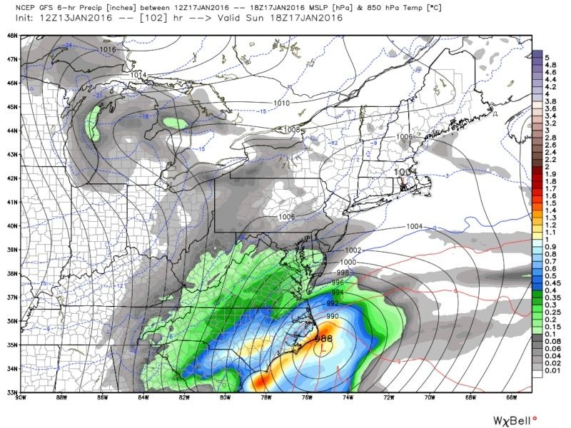
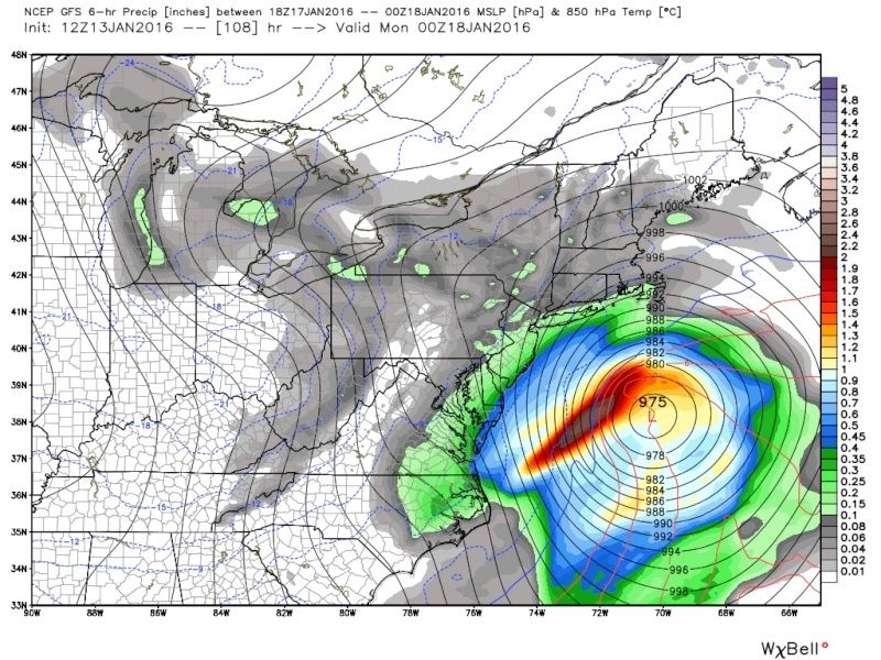
Well well well we may be focusing on the wrong system. the system for Sunday night and Monday just misses us Congrats to Charlotte Norfolk Virginia Delaware southern New Jersey and eastern Long Island snow does make it into the city but on the lite side. about 100 miles southeast of the benchmark a bomb. as I said yesterday this next 7 days will be our only chance to see snow this month

algae888- Advanced Forecaster

- Posts : 5311
Reputation : 46
Join date : 2013-02-05
Age : 62
Location : mt. vernon, new york
 Re: Long Range Thread 9.0
The possible MLK Day storm has its own thread.
_________________
_______________________________________________________________________________________________________
CLICK HERE to view NJ Strong Snowstorm Classifications

Quietace- Meteorologist - Mod

- Posts : 3689
Reputation : 33
Join date : 2013-01-07
Age : 27
Location : Point Pleasant, NJ

Quietace- Meteorologist - Mod

- Posts : 3689
Reputation : 33
Join date : 2013-01-07
Age : 27
Location : Point Pleasant, NJ
 Re: Long Range Thread 9.0
Quietace wrote:
If this is a winter of C-1" events its not gonna be a good year...

NjWeatherGuy- Advanced Forecaster

- Posts : 4100
Reputation : 28
Join date : 2013-01-06
Location : Belle Mead, NJ
 Re: Long Range Thread 9.0
I mentioned in yesterday's blog that if nothing works out over the next 10 days, January, we'll have to wait until February. Low heights are expected to park themselves over the west coast again around the 25th.

Also know that a February outlook will be released January 29th. It will either end winter or give you hope we can still reach our seasonal snowfall in February / March

Also know that a February outlook will be released January 29th. It will either end winter or give you hope we can still reach our seasonal snowfall in February / March
_________________
_______________________________________________________________________________________________________
CLICK HERE to view NJ Strong Snowstorm Classifications
 Re: Long Range Thread 9.0
20-22 storms looks interesting. -EPO looks to develop during that timeframe

Snow88- Senior Enthusiast

- Posts : 2193
Reputation : 4
Join date : 2013-01-09
Age : 36
Location : Brooklyn, NY
 Re: Long Range Thread 9.0
Gfs and cmc have Godzilla at same time frame. As said in banter if euro has it this could b real legit even 8 days or so out.

jmanley32- Senior Enthusiast

- Posts : 20646
Reputation : 108
Join date : 2013-12-12
Age : 43
Location : Yonkers, NY
 Re: Long Range Thread 9.0
Well, the Saturday thread will not come to fruition because of the ULL in southern Canada raising heights over the east coast. The MLK threat is likely to be some sort of inverted trough and those are insane to predict. Anyone's guess where it could set up. Our next threat comes next Friday. GFS showing a coastal system.

CAN WE FINALLY GET THE STARS TO ALIGN????

CAN WE FINALLY GET THE STARS TO ALIGN????
_________________
_______________________________________________________________________________________________________
CLICK HERE to view NJ Strong Snowstorm Classifications
 Re: Long Range Thread 9.0
Frank_Wx wrote:Well, the Saturday thread will not come to fruition because of the ULL in southern Canada raising heights over the east coast. The MLK threat is likely to be some sort of inverted trough and those are insane to predict. Anyone's guess where it could set up. Our next threat comes next Friday. GFS showing a coastal system.
CAN WE FINALLY GET THE STARS TO ALIGN????
I believe any details on this storm does the setup look good?

skinsfan1177- Senior Enthusiast

- Posts : 4485
Reputation : 35
Join date : 2013-01-07
Age : 47
Location : Point Pleasant Boro
 Re: Long Range Thread 9.0
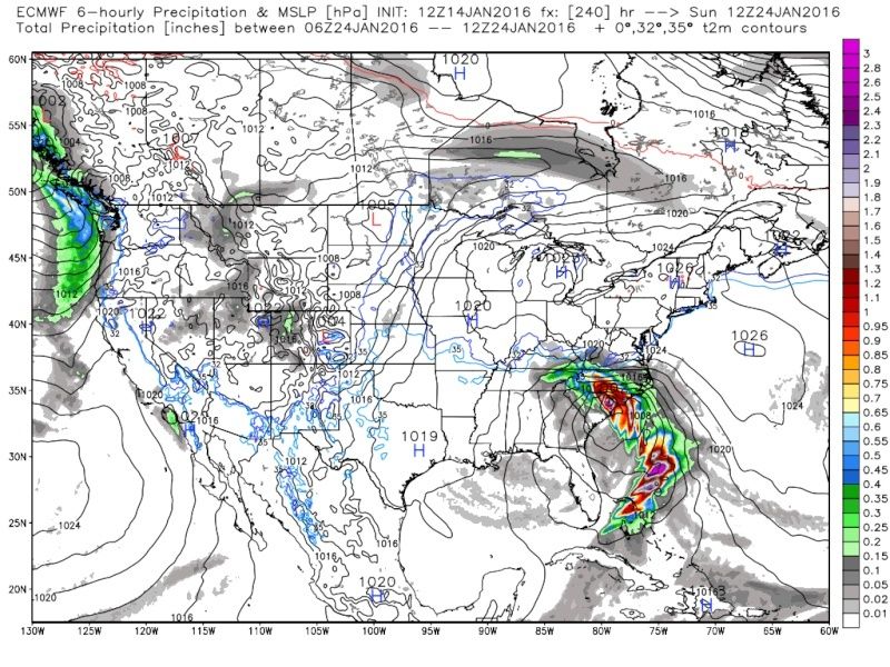
Frank it's a good sign that all 3 models have a storm signal around then this far out right? Euro has something in south at 240.

jmanley32- Senior Enthusiast

- Posts : 20646
Reputation : 108
Join date : 2013-12-12
Age : 43
Location : Yonkers, NY
 Re: Long Range Thread 9.0
jmanley32 wrote:Frank it's a good sign that all 3 models have a storm signal around then this far out right? Euro has something in south at 240.
Let us pray.

RJB8525- Senior Enthusiast

- Posts : 1994
Reputation : 28
Join date : 2013-02-06
Age : 38
Location : Hackettstown, NJ
 Re: Long Range Thread 9.0
Once again, the outcome of this storm is all up to the PAC. If the ridge out west collapses, this storm is likely heading out to sea or possibly even cutting. If there is a phase - like the 12z GFS shows - we'll get a storm up the coast even though the PAC ridge still collapsed. But it do so at an ideal time since the phase already happened and H5 closed off. This is a Godzilla verbatim.


_________________
_______________________________________________________________________________________________________
CLICK HERE to view NJ Strong Snowstorm Classifications
 Re: Long Range Thread 9.0
12z CMC jumps on board. This is getting exciting. Now watch, come Monday all of this will be cutting to our west because H5 closes off too early. UGHHHHHH


_________________
_______________________________________________________________________________________________________
CLICK HERE to view NJ Strong Snowstorm Classifications
 Re: Long Range Thread 9.0
The overnight runs had it too Frank, so its not just the 12z, actually the overnights looked better I thought. It is a bit more intriguing.

jmanley32- Senior Enthusiast

- Posts : 20646
Reputation : 108
Join date : 2013-12-12
Age : 43
Location : Yonkers, NY
 Re: Long Range Thread 9.0
Frank_Wx wrote:Once again, the outcome of this storm is all up to the PAC. If the ridge out west collapses, this storm is likely heading out to sea or possibly even cutting. If there is a phase - like the 12z GFS shows - we'll get a storm up the coast even though the PAC ridge still collapsed. But it do so at an ideal time since the phase already happened and H5 closed off. This is a Godzilla verbatim.
How is it a Godzilla verbatim, looks like mainly light precip, lets get that blue in here hehe

jmanley32- Senior Enthusiast

- Posts : 20646
Reputation : 108
Join date : 2013-12-12
Age : 43
Location : Yonkers, NY
 Re: Long Range Thread 9.0
Tropical tidbits (wxbell being slow) shows much heavier precip and totals around 12-16 inches...look Godzilla ruuuuunnn!

jmanley32- Senior Enthusiast

- Posts : 20646
Reputation : 108
Join date : 2013-12-12
Age : 43
Location : Yonkers, NY
 Re: Long Range Thread 9.0
Frank_Wx wrote:12z CMC jumps on board. This is getting exciting. Now watch, come Monday all of this will be cutting to our west because H5 closes off too early. UGHHHHHH
Frank......Frank.....Don't do this to us. I just quit on winter yesterday morning. Don't try to bring me back in!!!
I firmly believe this is the original threat we were looking at last weekend that the computer models lost and turned into this Fri. night's threat which now is not a big deal and maybe they start bringing Monday back which was the original threat all along and fit the date of the original threat/thread.
Guest- Guest
 Re: Long Range Thread 9.0
syosnow94 wrote:Frank_Wx wrote:12z CMC jumps on board. This is getting exciting. Now watch, come Monday all of this will be cutting to our west because H5 closes off too early. UGHHHHHH
Frank......Frank.....Don't do this to us. I just quit on winter yesterday morning. Don't try to bring me back in!!!


I firmly believe this is the original threat we were looking at last weekend that the computer models lost and turned into this Fri. night's threat which now is not a big deal and maybe they start bringing Monday back which was the original threat all along and fit the date of the original threat/thread.
syo this is next Friday the 22nd, look at hours 186.

jmanley32- Senior Enthusiast

- Posts : 20646
Reputation : 108
Join date : 2013-12-12
Age : 43
Location : Yonkers, NY
 Re: Long Range Thread 9.0
syosnow94 wrote: I just recognized that Jman.
But unlike the prior LR systems the 22nd has a lot of support this far out, Euro not in range yet but I suspect its holding back and will come in line and CMC is more northern driven but hoping will look more like GFS. Can't want to see what Euro does when it reaches us, this is what it looks like a 240. Not sure how to view the Euro para in this format on wxbell.


jmanley32- Senior Enthusiast

- Posts : 20646
Reputation : 108
Join date : 2013-12-12
Age : 43
Location : Yonkers, NY
 Re: Long Range Thread 9.0
Temps are in teens at 240 hrs, not sure if that surge of warmth comes with the LP on Euro or not, hoping not.

jmanley32- Senior Enthusiast

- Posts : 20646
Reputation : 108
Join date : 2013-12-12
Age : 43
Location : Yonkers, NY
 Re: Long Range Thread 9.0
Euro ensembles are encouraging some have mega bombs with godzillas, maybe about 15 or the individuals but ranging from 22nd to 25th. Not sure why the slower time frame but def a good sign to see the ensembles coming on board.
Theres still quite a spread butsome real bombs there and a def signal.

Theres still quite a spread butsome real bombs there and a def signal.


jmanley32- Senior Enthusiast

- Posts : 20646
Reputation : 108
Join date : 2013-12-12
Age : 43
Location : Yonkers, NY
 Re: Long Range Thread 9.0
The EPS look nothing like the OP.
I think we have ourselves a pretty good threat here. I will remain skeptical for the next 3 days because I do not trust the Pacific. It has screwed us too many times this season. We'll see....
I think we have ourselves a pretty good threat here. I will remain skeptical for the next 3 days because I do not trust the Pacific. It has screwed us too many times this season. We'll see....
_________________
_______________________________________________________________________________________________________
CLICK HERE to view NJ Strong Snowstorm Classifications
 Re: Long Range Thread 9.0
Frank_Wx wrote:The EPS look nothing like the OP.
I think we have ourselves a pretty good threat here. I will remain skeptical for the next 3 days because I do not trust the Pacific. It has screwed us too many times this season. We'll see....
Yes I think so too but not getting hyped just showing the maps I am seeing, after so many letdowns already I won't be terribly upset if this doesn't play out but I have more interest in this one than any other purely because all 3 models have a signal at this time, if it was just the gfs or just the cmc, wouldn't pay it any mind. Can't wait to see whats going on in 3 days. We need to get these two pesky letdowns out of here. You mean the EPS look better than OP right? And why the slower progression, its showing over the weekend rather than Fri like GFS and somewhat the CMC (though CMC doesn't really have a coastal).

jmanley32- Senior Enthusiast

- Posts : 20646
Reputation : 108
Join date : 2013-12-12
Age : 43
Location : Yonkers, NY
Page 16 of 40 •  1 ... 9 ... 15, 16, 17 ... 28 ... 40
Page 16 of 40
Permissions in this forum:
You cannot reply to topics in this forum
 Home
Home

