Long Range Thread 9.0
+51
Sparky Sparticles
track17
Grselig
snowday111
2004blackwrx
Joe Snow
GreyBeard
devsman
Mathgod55
deadrabbit79
jimv45
Taffy
Biggin23
crippo84
SNOW MAN
lglickman1
Dtone
Artechmetals
Dunnzoo
Vinnydula
Bkdude
SoulSingMG
oldtimer
Quietace
billg315
Math23x7
snow247
jake732
rb924119
Snowfall
Abba701
nutleyblizzard
Radz
RJB8525
justin92
chief7
hyde345
weatherwatchermom
CPcantmeasuresnow
frank 638
HectorO
Snow88
jmanley32
sroc4
skinsfan1177
algae888
amugs
docstox12
Frank_Wx
NjWeatherGuy
dsix85
55 posters
Page 17 of 40
Page 17 of 40 •  1 ... 10 ... 16, 17, 18 ... 28 ... 40
 Re: Long Range Thread 9.0
The EPS look nothing like the OP.
I think we have ourselves a pretty good threat here. I will remain skeptical for the next 3 days because I do not trust the Pacific. It has screwed us too many times this season. We'll see....
I think we have ourselves a pretty good threat here. I will remain skeptical for the next 3 days because I do not trust the Pacific. It has screwed us too many times this season. We'll see....
 Re: Long Range Thread 9.0
Frank_Wx wrote:The EPS look nothing like the OP.
I think we have ourselves a pretty good threat here. I will remain skeptical for the next 3 days because I do not trust the Pacific. It has screwed us too many times this season. We'll see....
Yes I think so too but not getting hyped just showing the maps I am seeing, after so many letdowns already I won't be terribly upset if this doesn't play out but I have more interest in this one than any other purely because all 3 models have a signal at this time, if it was just the gfs or just the cmc, wouldn't pay it any mind. Can't wait to see whats going on in 3 days. We need to get these two pesky letdowns out of here. You mean the EPS look better than OP right? And why the slower progression, its showing over the weekend rather than Fri like GFS and somewhat the CMC (though CMC doesn't really have a coastal).
jmanley32- Senior Enthusiast

- Posts : 20647
Join date : 2013-12-12
 Re: Long Range Thread 9.0
Jman. The Euro Op verbatim closes off the southern vort around texas. It completely closes off creating an upper level low (ULL) independant from the main flow so literally the ULL drifts east slowly over time. Hr 240 you can see it is just sitting on the SE coast. There really doesnt look like there is much of a mechanism to draw the ULL up the coast, so my guess would be that most if not all that energy would be bumped off the coast OTS, because the strong Pac jet crashing the west coast keeps everything moving along if we saw beyond 240hrs . Verbatim of course. EPS shows a different picture however. I WILL not get hyped nor will I HYpe any storm until its under 120hrs.


_________________
"In weather and in life, there's no winning and losing; there's only winning and learning."
WINTER 2012/2013 TOTALS 43.65"WINTER 2017/2018 TOTALS 62.85" WINTER 2022/2023 TOTALS 4.9"
WINTER 2013/2014 TOTALS 64.85"WINTER 2018/2019 TOTALS 14.25" WINTER 2023/2024 TOTALS 13.1"
WINTER 2014/2015 TOTALS 71.20"WINTER 2019/2020 TOTALS 6.35" WINTER 2024/2025 TOTALS 0.00
WINTER 2015/2016 TOTALS 35.00"WINTER 2020/2021 TOTALS 37.75"
WINTER 2016/2017 TOTALS 42.25"WINTER 2021/2022 TOTALS 31.65"

sroc4- Admin

- Posts : 8458
Reputation : 302
Join date : 2013-01-07
Location : Wading River, LI
 Re: Long Range Thread 9.0
It's pretty much thread the needle as it gets. The ridge is rolling east so you have to hope a phase / closed H5 occurs before it's east of the Rockies. We'll have the cold since Mondays systems will leave behind an arctic air mass. Plus there may be a nicely positioned HP. I wish the PAC looked better. Expect models to change drastically run to run.


_________________
_______________________________________________________________________________________________________
CLICK HERE to view NJ Strong Snowstorm Classifications
 Re: Long Range Thread 9.0
Frank_Wx wrote:It's pretty much thread the needle as it gets. The ridge is rolling east so you have to hope a phase / closed H5 occurs before it's east of the Rockies. We'll have the cold since Mondays systems will leave behind an arctic air mass. Plus there may be a nicely positioned HP. I wish the PAC looked better. Expect models to change drastically run to run.
Suppression could be a problem, ala 18z GFS, or the vort could close off or phase too early and cut again and we rain. Volataile situation and with the way this year is going ill try to pay it no mind until its more in range and we have a clearer picture and other mess of energies are out of the way first.
NjWeatherGuy- Advanced Forecaster

- Posts : 4100
Reputation : 28
Join date : 2013-01-06
Location : Belle Mead, NJ
 Re: Long Range Thread 9.0
But as of right now, I have to say like the central US HP setup "bananing" over SE Canada, classic setup and will provide cold air, but it needs to hold, unlike this disaster coming tomorrow night, thanks to a primary, bad modeling and no high pressure, terrible setup, like a spring or fall storm.

NjWeatherGuy- Advanced Forecaster

- Posts : 4100
Reputation : 28
Join date : 2013-01-06
Location : Belle Mead, NJ
 Re: Long Range Thread 9.0
So I know some on here think February we may lock into a better pattern. Their is Alot of chatter that weeklies for first half of Feb. Aren't that great and if that is true that doesn't leave us much time.

skinsfan1177- Senior Enthusiast

- Posts : 4485
Reputation : 35
Join date : 2013-01-07
Age : 47
Location : Point Pleasant Boro
 Re: Long Range Thread 9.0
skinsfan1177 wrote:So I know some on here think February we may lock into a better pattern. Their is Alot of chatter that weeklies for first half of Feb. Aren't that great and if that is true that doesn't leave us much time.
The euro weeklies for week 3-4 look just as bad as the week 3-4 looked back on Dec 24th. Week 3-4 are this week and next and it looks to be the coldest so far this winter whereas back on the 24th they looked horribly warm for these same two week. Point being ehh. Don't bother with the weeklies.
_________________
"In weather and in life, there's no winning and losing; there's only winning and learning."
WINTER 2012/2013 TOTALS 43.65"WINTER 2017/2018 TOTALS 62.85" WINTER 2022/2023 TOTALS 4.9"
WINTER 2013/2014 TOTALS 64.85"WINTER 2018/2019 TOTALS 14.25" WINTER 2023/2024 TOTALS 13.1"
WINTER 2014/2015 TOTALS 71.20"WINTER 2019/2020 TOTALS 6.35" WINTER 2024/2025 TOTALS 0.00
WINTER 2015/2016 TOTALS 35.00"WINTER 2020/2021 TOTALS 37.75"
WINTER 2016/2017 TOTALS 42.25"WINTER 2021/2022 TOTALS 31.65"

sroc4- Admin

- Posts : 8458
Reputation : 302
Join date : 2013-01-07
Location : Wading River, LI
 Re: Long Range Thread 9.0
I agree with sroc. That far off you need to look at overall patterns and trends leading up to the time frame rather than specific projections. Even then nothing is set in stone.

billg315- Advanced Forecaster - Mod

- Posts : 4564
Reputation : 185
Join date : 2015-01-24
Age : 50
Location : Flemington, NJ
 Re: Long Range Thread 9.0
Here's the deal with next Fridays storm. The 00z GFS tonight focused on a different piece of energy that actually sped up the timing of the storm by almost 48 hours. We do NOT want this. There is too much confluence over the northeast still so the upper energy would get sheared out. It's best if we try and get this storm from the second wave, or trailing energy. Heights over the east would be higher and there's better phasing opportunities
_________________
_______________________________________________________________________________________________________
CLICK HERE to view NJ Strong Snowstorm Classifications
 Re: Long Range Thread 9.0
The 00z GGEM and GFS tonight look drastically different for this reason.
_________________
_______________________________________________________________________________________________________
CLICK HERE to view NJ Strong Snowstorm Classifications
 Re: Long Range Thread 9.0
Frank just for reference in the last 20 yrs do you know if there was any yr where there was under 10 inches for the season
Artechmetals- Pro Enthusiast

- Posts : 571
Reputation : 3
Join date : 2014-01-01
Age : 57
Location : Wayne , NJ
 Re: Long Range Thread 9.0
Artechmetals wrote:Frank just for reference in the last 20 yrs do you know if there was any yr where there was under 10 inches for the season
1997-98: 5.5" (5.0" came on March 22nd)
2001-02: 3.5" (3.0" came on January 19th)
2011-12: 7.4" (2.9" came on October 29th)
Math23x7- Wx Statistician Guru

- Posts : 2382
Reputation : 68
Join date : 2013-01-08
 Re: Long Range Thread 9.0
Wow thanks math hope we don't get one if those yrs

Artechmetals- Pro Enthusiast

- Posts : 571
Reputation : 3
Join date : 2014-01-01
Age : 57
Location : Wayne , NJ
 Re: Long Range Thread 9.0
the CMC has the next wkend storm still
justin92- Posts : 16
Reputation : 0
Join date : 2016-01-01
 Re: Long Range Thread 9.0
Frank_Wx wrote:The 00z GGEM and GFS tonight look drastically different for this reason.
I am guessing not for the better?!

weatherwatchermom- Senior Enthusiast

- Posts : 3895
Reputation : 78
Join date : 2014-11-25
Location : Hazlet Township, NJ
 Re: Long Range Thread 9.0
weatherwatchermom wrote:Frank_Wx wrote:The 00z GGEM and GFS tonight look drastically different for this reason.
I am guessing not for the better?!
When has any model change this year been for the better?
Guest- Guest
 Re: Long Range Thread 9.0
Can someone explain to what it means for the Pac to cooperate

skinsfan1177- Senior Enthusiast

- Posts : 4485
Reputation : 35
Join date : 2013-01-07
Age : 47
Location : Point Pleasant Boro
 Re: Long Range Thread 9.0
skinsfan1177 wrote:Can someone explain to what it means for the Pac to cooperate
The Pacific ridge, You want it extending up into western Canada so the cold air and energy drops southeastwards into our area. With El Nino the warm air crashes into the west coast bringing tons of moisture into California and flattening the ridge.
Guest- Guest
 Re: Long Range Thread 9.0
skinsfan1177 wrote:Can someone explain to what it means for the Pac to cooperate
In general that's a pretty complex question. In a nutshell we have had convection in and around the dateline for some time. We have had that convection focused to that area pretty much the entire season so far. However we have only seen transient influences on the sub Aleutian trough. Instead of that area locking in that trough south of the Aleutian Islands which in turn would promote a amplified strong ridge complex along the west coast of North America we have had other influences specifically the convection in the Indian Ocean influencing the polar jet more strongly, and more consistently. The result of this influence has been more of a progressive pacific jet across the entire northern third of the pacific. The result of this progressive and fairly strong flow across the Pacific is to send piece after piece of 500 mb energy into our West Coast deamplifying the ridging in that area. So we can never really get, to this point, northern energy to phase with Southern energy because there's no amplification of that ridging. Unfortunately it looks like the current pulse of energy and convection in the Indian Ocean seems to become becoming stronger. We will have to see if this area relaxes some but if it doesn't and the MJ oh makes it into faces three and specially for we may need that stratospheric warming event as an absolute key to save our winter.
That's my take simply stated. Maybe Frank or others could comment.
_________________
"In weather and in life, there's no winning and losing; there's only winning and learning."
WINTER 2012/2013 TOTALS 43.65"WINTER 2017/2018 TOTALS 62.85" WINTER 2022/2023 TOTALS 4.9"
WINTER 2013/2014 TOTALS 64.85"WINTER 2018/2019 TOTALS 14.25" WINTER 2023/2024 TOTALS 13.1"
WINTER 2014/2015 TOTALS 71.20"WINTER 2019/2020 TOTALS 6.35" WINTER 2024/2025 TOTALS 0.00
WINTER 2015/2016 TOTALS 35.00"WINTER 2020/2021 TOTALS 37.75"
WINTER 2016/2017 TOTALS 42.25"WINTER 2021/2022 TOTALS 31.65"

sroc4- Admin

- Posts : 8458
Reputation : 302
Join date : 2013-01-07
Location : Wading River, LI
 Re: Long Range Thread 9.0
sroc4 wrote:skinsfan1177 wrote:Can someone explain to what it means for the Pac to cooperate
In general that's a pretty complex question. In a nutshell we have had convection in and around the dateline for some time. We have had that convection focused to that area pretty much the entire season so far. However we have only seen transient influences on the sub Aleutian trough. Instead of that area locking in that trough south of the Aleutian Islands which in turn would promote a amplified strong ridge complex along the west coast of North America we have had other influences specifically the convection in the Indian Ocean influencing the polar jet more strongly, and more consistently. The result of this influence has been more of a progressive pacific jet across the entire northern third of the pacific. The result of this progressive and fairly strong flow across the Pacific is to send piece after piece of 500 mb energy into our West Coast deamplifying the ridging in that area. So we can never really get, to this point, northern energy to phase with Southern energy because there's no amplification of that ridging. Unfortunately it looks like the current pulse of energy and convection in the Indian Ocean seems to become becoming stronger. We will have to see if this area relaxes some but if it doesn't and the MJ oh makes it into faces three and specially for we may need that stratospheric warming event as an absolute key to save our winter.
That's my take simply stated. Maybe Frank or others could comment.
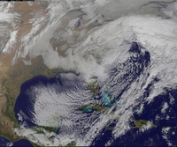
To illustrate that point further this is the current look at the flow across the PAC as per the Euro. Notice just how progressive it is through out the Pac: The result of this are multiple lobes of ULL in and around the Aluetian Islands instead of one strong deep ULL and associated trough S of the A Islands. The strong progressive Pac flow is leading to pieces of those ULL(yellow X and arrow) to constantly break off and undercut the west coast ridging de-amplifying it. There is still some ridging in the west. That's why we are getting outr cold/cool shots, but its transient and constantly being dampened because of these factors in the Pac.
 " />
" /> " />
" />Here you can clearly see the enhancement of thePac/Polar jet via convection in the Indian Ocean. Actual observation of the models depiction of the upper flow across the Pac. Sat image:

Now if the Pac were to "BEHAVE " better, we would want it to look more like this.

Instead of a west to east orientation we want a more N to S orientation to the Pac flow. One of two things or both are needed for this to happen. We need the Indian Ocean to quite down. This might allow the convection around the dateline to the draw the Aleutian trough further S of the islands. This would consolidate all the energy into one deep trough. In theory this then amplifys the ridge out ahead. And when pieces of energy break off it(yellow X and arrow) they are forced up and over the strong west coast ridge only to dive down into the central conus with more gusto then we have had so far and the chances for phasing increases with the STJ.
The other "thing" we need to happen, and honestly this is probably the most important as I don't think the IO shuts down without this, is the Strat warming. A warm strat over the N pole leads to expanding air pushing down on the Troposhpere. This would in theory push the Aleutian trough further south as a result and hopefully allow it to link back up more strongly and consistently with the convection around the dateline. Without that the Pac remains progressive and the Convection in the tropics continues to enhance the STJ only instead of both the STJ, AND the Aleutian trough and we need the timing of our N and S energies to be perfect.
_________________
"In weather and in life, there's no winning and losing; there's only winning and learning."
WINTER 2012/2013 TOTALS 43.65"WINTER 2017/2018 TOTALS 62.85" WINTER 2022/2023 TOTALS 4.9"
WINTER 2013/2014 TOTALS 64.85"WINTER 2018/2019 TOTALS 14.25" WINTER 2023/2024 TOTALS 13.1"
WINTER 2014/2015 TOTALS 71.20"WINTER 2019/2020 TOTALS 6.35" WINTER 2024/2025 TOTALS 0.00
WINTER 2015/2016 TOTALS 35.00"WINTER 2020/2021 TOTALS 37.75"
WINTER 2016/2017 TOTALS 42.25"WINTER 2021/2022 TOTALS 31.65"

sroc4- Admin

- Posts : 8458
Reputation : 302
Join date : 2013-01-07
Location : Wading River, LI
 Re: Long Range Thread 9.0
syosnow94 wrote:We're Screwed basically.!!!
Not yet
_________________
"In weather and in life, there's no winning and losing; there's only winning and learning."
WINTER 2012/2013 TOTALS 43.65"WINTER 2017/2018 TOTALS 62.85" WINTER 2022/2023 TOTALS 4.9"
WINTER 2013/2014 TOTALS 64.85"WINTER 2018/2019 TOTALS 14.25" WINTER 2023/2024 TOTALS 13.1"
WINTER 2014/2015 TOTALS 71.20"WINTER 2019/2020 TOTALS 6.35" WINTER 2024/2025 TOTALS 0.00
WINTER 2015/2016 TOTALS 35.00"WINTER 2020/2021 TOTALS 37.75"
WINTER 2016/2017 TOTALS 42.25"WINTER 2021/2022 TOTALS 31.65"

sroc4- Admin

- Posts : 8458
Reputation : 302
Join date : 2013-01-07
Location : Wading River, LI
 Re: Long Range Thread 9.0
sroc4 wrote:sroc4 wrote:skinsfan1177 wrote:Can someone explain to what it means for the Pac to cooperate
In general that's a pretty complex question. In a nutshell we have had convection in and around the dateline for some time. We have had that convection focused to that area pretty much the entire season so far. However we have only seen transient influences on the sub Aleutian trough. Instead of that area locking in that trough south of the Aleutian Islands which in turn would promote a amplified strong ridge complex along the west coast of North America we have had other influences specifically the convection in the Indian Ocean influencing the polar jet more strongly, and more consistently. The result of this influence has been more of a progressive pacific jet across the entire northern third of the pacific. The result of this progressive and fairly strong flow across the Pacific is to send piece after piece of 500 mb energy into our West Coast deamplifying the ridging in that area. So we can never really get, to this point, northern energy to phase with Southern energy because there's no amplification of that ridging. Unfortunately it looks like the current pulse of energy and convection in the Indian Ocean seems to become becoming stronger. We will have to see if this area relaxes some but if it doesn't and the MJ oh makes it into faces three and specially for we may need that stratospheric warming event as an absolute key to save our winter.
That's my take simply stated. Maybe Frank or others could comment.
To illustrate that point further this is the current look at the flow across the PAC as per the Euro. Notice just how progressive it is through out the Pac: The result of this are multiple lobes of ULL in and around the Aluetian Islands instead of one strong deep ULL and associated trough S of the A Islands. The strong progressive Pac flow is leading to pieces of those ULL(yellow X and arrow) to constantly break off and undercut the west coast ridging de-amplifying it. There is still some ridging in the west. That's why we are getting outr cold/cool shots, but its transient and constantly being dampened because of these factors in the Pac." />
" />
Here you can clearly see the enhancement of thePac/Polar jet via convection in the Indian Ocean. Actual observation of the models depiction of the upper flow across the Pac. Sat image:
Now if the Pac were to "BEHAVE " better, we would want it to look more like this.
Instead of a west to east orientation we want a more N to S orientation to the Pac flow. One of two things or both are needed for this to happen. We need the Indian Ocean to quite down. This might allow the convection around the dateline to the draw the Aleutian trough further S of the islands. This would consolidate all the energy into one deep trough. In theory this then amplifys the ridge out ahead. And when pieces of energy break off it(yellow X and arrow) they are forced up and over the strong west coast ridge only to dive down into the central conus with more gusto then we have had so far and the chances for phasing increases with the STJ.
The other "thing" we need to happen, and honestly this is probably the most important as I don't think the IO shuts down without this, is the Strat warming. A warm strat over the N pole leads to expanding air pushing down on the Troposhpere. This would in theory push the Aleutian trough further south as a result and hopefully allow it to link back up more strongly and consistently with the convection around the dateline. Without that the Pac remains progressive and the Convection in the tropics continues to enhance the STJ only instead of both the STJ, AND the Aleutian trough and we need the timing of our N and S energies to be perfect.
Thank you sroc for the the incredible explanation I appreciate it.

skinsfan1177- Senior Enthusiast

- Posts : 4485
Reputation : 35
Join date : 2013-01-07
Age : 47
Location : Point Pleasant Boro
 Re: Long Range Thread 9.0
You bet Skins. These sorts of questions force me to look at things at diff angles, so thank you.
_________________
"In weather and in life, there's no winning and losing; there's only winning and learning."
WINTER 2012/2013 TOTALS 43.65"WINTER 2017/2018 TOTALS 62.85" WINTER 2022/2023 TOTALS 4.9"
WINTER 2013/2014 TOTALS 64.85"WINTER 2018/2019 TOTALS 14.25" WINTER 2023/2024 TOTALS 13.1"
WINTER 2014/2015 TOTALS 71.20"WINTER 2019/2020 TOTALS 6.35" WINTER 2024/2025 TOTALS 0.00
WINTER 2015/2016 TOTALS 35.00"WINTER 2020/2021 TOTALS 37.75"
WINTER 2016/2017 TOTALS 42.25"WINTER 2021/2022 TOTALS 31.65"

sroc4- Admin

- Posts : 8458
Reputation : 302
Join date : 2013-01-07
Location : Wading River, LI
 Re: Long Range Thread 9.0
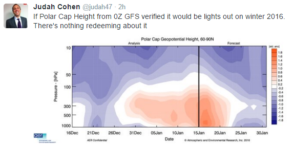
This is not good news about the PV from Dr Cohen who was adamant about this

_________________
Mugs
AKA:King: Snow Weenie
Self Proclaimed
WINTER 2014-15 : 55.12" +.02 for 6 coatings (avg. 35")
WINTER 2015-16 Total - 29.8" (Avg 35")
WINTER 2016-17 : 39.5" so far

amugs- Advanced Forecaster - Mod

- Posts : 15157
Reputation : 213
Join date : 2013-01-07
Age : 54
Location : Hillsdale,NJ
Page 17 of 40 •  1 ... 10 ... 16, 17, 18 ... 28 ... 40
Page 17 of 40
Permissions in this forum:
You cannot reply to topics in this forum
 Home
Home