Long Range Thread 9.0
+51
Sparky Sparticles
track17
Grselig
snowday111
2004blackwrx
Joe Snow
GreyBeard
devsman
Mathgod55
deadrabbit79
jimv45
Taffy
Biggin23
crippo84
SNOW MAN
lglickman1
Dtone
Artechmetals
Dunnzoo
Vinnydula
Bkdude
SoulSingMG
oldtimer
Quietace
billg315
Math23x7
snow247
jake732
rb924119
Snowfall
Abba701
nutleyblizzard
Radz
RJB8525
justin92
chief7
hyde345
weatherwatchermom
CPcantmeasuresnow
frank 638
HectorO
Snow88
jmanley32
sroc4
skinsfan1177
algae888
amugs
docstox12
Frank_Wx
NjWeatherGuy
dsix85
55 posters
Page 18 of 40
Page 18 of 40 •  1 ... 10 ... 17, 18, 19 ... 29 ... 40
 Re: Long Range Thread 9.0
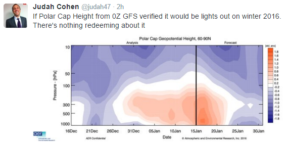
This is not good news about the PV from Dr Cohen who was adamant about this


amugs- Advanced Forecaster - Mod

- Posts : 15156
Join date : 2013-01-07
 Re: Long Range Thread 9.0
As Sroc pointed out the IO is killing our ridge sending in closed vorts into the west coast like rush hour at the GW bridge. Everyone we get the ridge to rise a wave undercuts it, crashes in. If you look at the PAC it is a mess with vort after vort, so much Frickin energy.

A train of LP not enough spacing. Need the IO to shut down so we can get that AL LP to pull back and act like a NPAC block as the euro showed for the last 5 months.

The weather 20k miles away is affecting our weather in our backyards.
These are not allowing the EC LP to phase nor the heights to recover on the WC to allow tjis and turn these storms N.
We wait to see if the IO shuts down aND thestate if the PV. I trust Isotherm on this one, PV state.

A train of LP not enough spacing. Need the IO to shut down so we can get that AL LP to pull back and act like a NPAC block as the euro showed for the last 5 months.

The weather 20k miles away is affecting our weather in our backyards.
These are not allowing the EC LP to phase nor the heights to recover on the WC to allow tjis and turn these storms N.
We wait to see if the IO shuts down aND thestate if the PV. I trust Isotherm on this one, PV state.
_________________
Mugs
AKA:King: Snow Weenie
Self Proclaimed
WINTER 2014-15 : 55.12" +.02 for 6 coatings (avg. 35")
WINTER 2015-16 Total - 29.8" (Avg 35")
WINTER 2016-17 : 39.5" so far

amugs- Advanced Forecaster - Mod

- Posts : 15156
Reputation : 213
Join date : 2013-01-07
Age : 54
Location : Hillsdale,NJ
 Re: Long Range Thread 9.0
amugs wrote:As Sroc pointed out the IO is killing our ridge sending in closed vorts into the west coast like rush hour at the GW bridge. Everyone we get the ridge to rise a wave undercuts it, crashes in. If you look at the PAC it is a mess with vort after vort, so much Frickin energy.
A train of LP not enough spacing. Need the IO to shut down so we can get that AL LP to pull back and act like a NPAC block as the euro showed for the last 5 months.
The weather 20k miles away is affecting our weather in our backyards.
These are not allowing the EC LP to phase nor the heights to recover on the WC to allow tjis and turn these storms N.
We wait to see if the IO shuts down aND thestate if the PV. I trust Isotherm on this one, PV state.
It will shut down come April.
Guest- Guest
 Re: Long Range Thread 9.0
amugs wrote:This is not good news about the PV from Dr Cohen who was adamant about this
So my prediction of 7.2 inches of snow for Dec-Feb in the contest is going to bust as wildly optimistic. I'm not surprised.

CPcantmeasuresnow- Wx Statistician Guru

- Posts : 7288
Reputation : 230
Join date : 2013-01-07
Age : 103
Location : Eastern Orange County, NY
 Re: Long Range Thread 9.0
And so the 22nd storm is ziltch on GFS not surprised. I really think anyone who has hopes for this winter is sorely mistaken. There are so many thing working agaist it and LR does not look that gr8 from what I have been reading. I guess my snow guess will be so high it'd b a world record for this yr lol

jmanley32- Senior Enthusiast

- Posts : 20646
Reputation : 108
Join date : 2013-12-12
Age : 43
Location : Yonkers, NY
 Re: Long Range Thread 9.0
Jman it's probably a good thing that the GFS has lost the storm and focuses on the first one midweek. From what I can see no other model has that storm. The Canadian still shows a coastal for late next week and early next weekend the Euro also focuses on that wave although it cuts it off down south. I'll trust the other two models rather than the GFS until another model trends towards it

algae888- Advanced Forecaster

- Posts : 5311
Reputation : 46
Join date : 2013-02-05
Age : 62
Location : mt. vernon, new york
 Re: Long Range Thread 9.0
If we get any kind of system to come together big or small it will unlikely be seen on any LR guidance. With as much energy associated with N and S branches you need not look beyond 3-5days out with any kind of confidence. The pattern is once again in a state of flux. We will not be back into the DEc pattern at all, but we are far from locked into any sort of stable pattern. Therefore; I will join many of you in frustration; however with nothing more than a mere grumble, and disapointment for now. I will cont to keep it in the banter thread though. Lets try to keep the LR thread clean with analysis and productive discussion instead of rants of frustration.
Keep in mind long range projections are simply that. In a year when no one has been able to predict whats going to happen anything can still happen. (Sroc-ism #4)
Keep in mind long range projections are simply that. In a year when no one has been able to predict whats going to happen anything can still happen. (Sroc-ism #4)
_________________
"In weather and in life, there's no winning and losing; there's only winning and learning."
WINTER 2012/2013 TOTALS 43.65"WINTER 2017/2018 TOTALS 62.85" WINTER 2022/2023 TOTALS 4.9"
WINTER 2013/2014 TOTALS 64.85"WINTER 2018/2019 TOTALS 14.25" WINTER 2023/2024 TOTALS 13.1"
WINTER 2014/2015 TOTALS 71.20"WINTER 2019/2020 TOTALS 6.35" WINTER 2024/2025 TOTALS 0.00
WINTER 2015/2016 TOTALS 35.00"WINTER 2020/2021 TOTALS 37.75"
WINTER 2016/2017 TOTALS 42.25"WINTER 2021/2022 TOTALS 31.65"

sroc4- Admin

- Posts : 8458
Reputation : 302
Join date : 2013-01-07
Location : Wading River, LI
 Re: Long Range Thread 9.0
My gut tells me that today's euro will show a snowstorm for next weekend. Last night's wasn't far from a phase in a pretty good spot. It had a positively tilted trough just west of the Mississippi but for some reason it cut off the southern stream over the Gulf. As Scott just said models are going to have a hard time with the overall pattern past 5 days.
Edit: I mean the Euro with show a storm for us next weekend whether it's snow or rain or some mix we'll just have to wait and see
Edit: I mean the Euro with show a storm for us next weekend whether it's snow or rain or some mix we'll just have to wait and see

algae888- Advanced Forecaster

- Posts : 5311
Reputation : 46
Join date : 2013-02-05
Age : 62
Location : mt. vernon, new york
 Re: Long Range Thread 9.0
Yeah the CMC was a big hit, lots precip, temps iffy on coast but that's neither here nor there. I bet the Euro shows a big coastal too. The GFS has always been crummy LR, I actually been trust CMC more than GFS and Euro first.

jmanley32- Senior Enthusiast

- Posts : 20646
Reputation : 108
Join date : 2013-12-12
Age : 43
Location : Yonkers, NY
 Re: Long Range Thread 9.0
my gut was wrong about the euro. however today's euro is close to a phase and storm. ridge in the west to far east and the southern s/w much weaker. still close though. we wait...


big diff in the strength of southern s/w from last two days run. plus the system coming into the west coast just pushes everything east very fast.


big diff in the strength of southern s/w from last two days run. plus the system coming into the west coast just pushes everything east very fast.

algae888- Advanced Forecaster

- Posts : 5311
Reputation : 46
Join date : 2013-02-05
Age : 62
Location : mt. vernon, new york
 Re: Long Range Thread 9.0
well at least we have the jma on board. lol


algae888- Advanced Forecaster

- Posts : 5311
Reputation : 46
Join date : 2013-02-05
Age : 62
Location : mt. vernon, new york
 Re: Long Range Thread 9.0
Bad day of model runs. Unless you trust the JMA 
_________________
_______________________________________________________________________________________________________
CLICK HERE to view NJ Strong Snowstorm Classifications
 Re: Long Range Thread 9.0
CPcantmeasuresnow wrote:amugs wrote:This is not good news about the PV from Dr Cohen who was adamant about this
So my prediction of 7.2 inches of snow for Dec-Feb in the contest is going to bust as wildly optimistic. I'm not surprised.
I said 12" I thought I was low. In my head I reached that number thinking almost all of that in Feb with nothing in Dec, and no more than a couple inches in Jan but with much more N&W. but even up your way its been a dud. I've not given up yet though. Maybe this is not the year for consistent snow but it just takes a couple big events to approach avg.
Dtone- Wx Statistician Guru

- Posts : 1738
Reputation : 9
Join date : 2013-08-26
Location : Bronx, NY
 Re: Long Range Thread 9.0
Frank_Wx wrote:Bad day of model runs. Unless you trust the JMA
Im picking up what your putting down Frank...
 What your saying is for the past few weeks the Md and LR has looked so promising only to fall to sh-- as we approach the Md-SR range. So since we now have a Sh--y MD-LR we should eventually flip to AMAZING in the MD-SR once the current MD-LR gets into the MD-SR.........right?
_________________
"In weather and in life, there's no winning and losing; there's only winning and learning."
WINTER 2012/2013 TOTALS 43.65"WINTER 2017/2018 TOTALS 62.85" WINTER 2022/2023 TOTALS 4.9"
WINTER 2013/2014 TOTALS 64.85"WINTER 2018/2019 TOTALS 14.25" WINTER 2023/2024 TOTALS 13.1"
WINTER 2014/2015 TOTALS 71.20"WINTER 2019/2020 TOTALS 6.35" WINTER 2024/2025 TOTALS 0.00
WINTER 2015/2016 TOTALS 35.00"WINTER 2020/2021 TOTALS 37.75"
WINTER 2016/2017 TOTALS 42.25"WINTER 2021/2022 TOTALS 31.65"

sroc4- Admin

- Posts : 8458
Reputation : 302
Join date : 2013-01-07
Location : Wading River, LI
 Re: Long Range Thread 9.0
Scott when I look at the mjo guidance from today on all the models almost everyone has it in the circle of death for the next two weeks. I've been hearing from other boards that it's going to be in phase two and three and pretty amplified but that's not what I'm seeing. Am I missing something and what effect would the circle of death have compared to an amplified phase 2 & 3 ?

algae888- Advanced Forecaster

- Posts : 5311
Reputation : 46
Join date : 2013-02-05
Age : 62
Location : mt. vernon, new york
 Re: Long Range Thread 9.0
Winter outlooks are in great danger if the Strat PV does not get displaced. El Nino has not cooled to moderate levels like MOST ENSO guidance was showing in OCT-NOV would happen. With El Nino remaining strong and the Strat PV possible remaining strong over the arctic, there's a good chance my winter outlook will not verify.
Next Fridays storm is still on the table. Some ensemble members blow up a storm off the coast. But with the PAC an absolute mess I don't see how a ridge stays amplified enough to allow a storm to come up the coast. My confidence level is less than 30%.
The EURO ENS show a December-like pattern January 23rd-Feb 1st. The last week of January looks above normal.
From a temp standpoint, my outlook isn't doing too bad. But if the aforementioned signals don't approve, largely the PV, February could end near to slightly above average instead of below avg how I predicted. Let's just say I'm a little down on long range prospects right now. I hope 1 week from now things looks better. We'll see.
_________________
_______________________________________________________________________________________________________
CLICK HERE to view NJ Strong Snowstorm Classifications
 Re: Long Range Thread 9.0
18z gfs has the storm again lol. Snow to rain verbatim but obviously too far out for any details it is a monster though

algae888- Advanced Forecaster

- Posts : 5311
Reputation : 46
Join date : 2013-02-05
Age : 62
Location : mt. vernon, new york
 Re: Long Range Thread 9.0
I may hibernate until ENSO neutral / weak La Nina expected next winter. As I said El Nino may have ended up being the wildcard in this winter, it has not sufficiently cooled fast enough and it is still too strong. In addition the pacific overall has been and looks to continue to be a mess with vorts slamming into the west coast one after another causing progressive flow. Ultimately I want to say we can keep waiting for this to change but I think its too late for this year. Yeah its too early to write off winter with a warm and snowless November, obviously, but December becomes disconcerning, now we've burned through almost all of January with hardly anything to show for it. The LR doesn't look impressive either. So sadly, I dont think this will be a cold and snowy winter overall anymore and agree with NOAAs revised outlook (albeit they made the call early) of above normal temps and below normal snowfall. That doesnt mean we wont see snow or cold or even a big storm, but we've burned through too much winter and the forecast just looks too bad to add up to an above normal year in terms of snowfall in my opinion.
Last edited by NjWeatherGuy on Fri Jan 15, 2016 6:35 pm; edited 2 times in total

NjWeatherGuy- Advanced Forecaster

- Posts : 4100
Reputation : 28
Join date : 2013-01-06
Location : Belle Mead, NJ
 Re: Long Range Thread 9.0
Done till next year you guys stay strong this green horn abandoned ship
Snowfall- Posts : 59
Reputation : 0
Join date : 2015-12-31
 Re: Long Range Thread 9.0
A couple questions when does El niino weaken I mean it can't stay strong forever correct? And how do we predict if it will be El Nino or la Nina next year

skinsfan1177- Senior Enthusiast

- Posts : 4485
Reputation : 35
Join date : 2013-01-07
Age : 47
Location : Point Pleasant Boro
 Re: Long Range Thread 9.0
Euro Para has some good news
.png)
R.png)
.png)
.png)
.png)
R
.png)
.png)
.png)
_________________
Mugs
AKA:King: Snow Weenie
Self Proclaimed
WINTER 2014-15 : 55.12" +.02 for 6 coatings (avg. 35")
WINTER 2015-16 Total - 29.8" (Avg 35")
WINTER 2016-17 : 39.5" so far

amugs- Advanced Forecaster - Mod

- Posts : 15156
Reputation : 213
Join date : 2013-01-07
Age : 54
Location : Hillsdale,NJ
 Re: Long Range Thread 9.0
Why are people cancelling winter? SMH

Snow88- Senior Enthusiast

- Posts : 2193
Reputation : 4
Join date : 2013-01-09
Age : 36
Location : Brooklyn, NY
 Re: Long Range Thread 9.0
Snow88 wrote:Why are people cancelling winter? SMH
Snow I guess due to the LR model runs today, need the pac to imorove. We just nned the PV to help us going forward along wi5h the Aluetian LP to retrograde sw so we can get the heights to rise along the WC and a -epo to form. Para showing some good signs here. Time will tell.
_________________
Mugs
AKA:King: Snow Weenie
Self Proclaimed
WINTER 2014-15 : 55.12" +.02 for 6 coatings (avg. 35")
WINTER 2015-16 Total - 29.8" (Avg 35")
WINTER 2016-17 : 39.5" so far

amugs- Advanced Forecaster - Mod

- Posts : 15156
Reputation : 213
Join date : 2013-01-07
Age : 54
Location : Hillsdale,NJ
 Re: Long Range Thread 9.0
Nino is stubborn, there are many other factors here but this is one that is NOT helping the other parameters come together for us.
http://www.cpc.ncep.noaa.gov/products/analysis_monitoring/enso_advisory/figure2.gi
MJO, 2 to COD, bleh
http://www.cpc.ncep.noaa.gov/products/precip/CWlink/MJO/foregfs.shtml
NAO, models seem lost here
http://www.cpc.ncep.noaa.gov/products/precip/CWlink/pna/nao.sprd2.gif
PNA, maintained slightly positive
http://www.cpc.ncep.noaa.gov/products/precip/CWlink/pna/pna.sprd2.gif
AO, headed positive
http://www.cpc.ncep.noaa.gov/products/precip/CWlink/daily_ao_index/ao_index_ensm.shtml
GFS ens shows the EPO maintaining slightly positive, then dipping negative, then returning positive, not good news, likely continuing the barrage of vorts into the west coast and the fast flow, likely more important than other teleconnections.

NjWeatherGuy- Advanced Forecaster

- Posts : 4100
Reputation : 28
Join date : 2013-01-06
Location : Belle Mead, NJ
 Re: Long Range Thread 9.0
0z GFS is just offshore with next weekends storm

Snow88- Senior Enthusiast

- Posts : 2193
Reputation : 4
Join date : 2013-01-09
Age : 36
Location : Brooklyn, NY
 Re: Long Range Thread 9.0
0z GGEM is also weak and OTS

Snow88- Senior Enthusiast

- Posts : 2193
Reputation : 4
Join date : 2013-01-09
Age : 36
Location : Brooklyn, NY
Page 18 of 40 •  1 ... 10 ... 17, 18, 19 ... 29 ... 40
Page 18 of 40
Permissions in this forum:
You cannot reply to topics in this forum
 Home
Home