Long Range Thread 9.0
+51
Sparky Sparticles
track17
Grselig
snowday111
2004blackwrx
Joe Snow
GreyBeard
devsman
Mathgod55
deadrabbit79
jimv45
Taffy
Biggin23
crippo84
SNOW MAN
lglickman1
Dtone
Artechmetals
Dunnzoo
Vinnydula
Bkdude
SoulSingMG
oldtimer
Quietace
billg315
Math23x7
snow247
jake732
rb924119
Snowfall
Abba701
nutleyblizzard
Radz
RJB8525
justin92
chief7
hyde345
weatherwatchermom
CPcantmeasuresnow
frank 638
HectorO
Snow88
jmanley32
sroc4
skinsfan1177
algae888
amugs
docstox12
Frank_Wx
NjWeatherGuy
dsix85
55 posters
Page 31 of 40
Page 31 of 40 •  1 ... 17 ... 30, 31, 32 ... 35 ... 40
 Re: Long Range Thread 9.0
algae888 wrote:Starting to see hints of the -ao/nao coming back after the relax. A 3-4 day warm stretch and then back to tracking if that. Seriously doubt a prolonged trough/west ridge east like Dec. also look at enso 1.2...
crashing!!! man I may have been so wrong to give up on this winter. have to trust scott and frank more!!!
If we never had the wwb in late Dec early jan just think where we would be? Could have had a couple of snowstorms under our belts at this point. Don't fret as of we'd I was concerned as to the pattern going forward after checking in a couple of pro mets I know and others. Only Isotherm ND earthlight told me contrary but weren't sure and had some doubts as well.
Great sign and buckle up Paisan cause I think we are going to be in for one hell of a ride from nj ow until mid March
amugs- Advanced Forecaster - Mod

- Posts : 15156
Join date : 2013-01-07
 Re: Long Range Thread 9.0
The storm signal for the 30th is just as good just one at a time
Snowfall- Posts : 59
Join date : 2015-12-31
 Re: Long Range Thread 9.0
I heard it will warm up again first week February? Anyone know how much?
Abba701- Posts : 328
Reputation : 0
Join date : 2013-01-14
 Re: Long Range Thread 9.0
deadrabbit79 wrote:Dont jinx it!! No Thread until the storm is at least a day away or confirmed!!!
I tried.............
deadrabbit79- Posts : 176
Reputation : 6
Join date : 2013-01-25
Location : Hartsdale, New York
 Re: Long Range Thread 9.0
[quote="amugs"]Well well well will u look at this for next wed/turd day storm GEFS barking here miller a it is says no ti the op for its rum and shows a euro similar solution
When it rains it pours peeps, no rest for the weary,
 [/quote
Mugs, I would gladly concede this fri/sat storm for a potential Miller A on the 28th. But the again I have an ulterior motive, my wife and daughter are due to return from a cruise and their return flight is scheduled for Saturday at 7:00 PM which would probably be at the height of the storm. From what I've been reading there's another on behind that too so plenty of opportunities for something to verify.
When it rains it pours peeps, no rest for the weary,
 [/quote
Mugs, I would gladly concede this fri/sat storm for a potential Miller A on the 28th. But the again I have an ulterior motive, my wife and daughter are due to return from a cruise and their return flight is scheduled for Saturday at 7:00 PM which would probably be at the height of the storm. From what I've been reading there's another on behind that too so plenty of opportunities for something to verify.
GreyBeard- Senior Enthusiast

- Posts : 732
Reputation : 34
Join date : 2014-02-12
Location : Boca Raton, Fl.
 Re: Long Range Thread 9.0
Abba701 wrote:I heard it will warm up again first week February? Anyone know how much?
At least in the 50's for now, is what is showing.

HectorO- Pro Enthusiast

- Posts : 977
Reputation : 27
Join date : 2013-01-11
 Re: Long Range Thread 9.0
Well, after I get an inch from the storm this weekend then the one on the 28th can screw me again. 

hyde345- Pro Enthusiast

- Posts : 1084
Reputation : 48
Join date : 2013-01-08
Location : Hyde Park, NY
 Re: Long Range Thread 9.0
I just watched the Mets/Prof out at Penn state give their 30 day outlook. They said there would be limited Artic air and that there would be at least 4 events that would be more soggy than white because we will be in a Southwest flow. The outlook goes from today until February 17th.
I guess we'll see if their right. I hope not.
I guess we'll see if their right. I hope not.

SNOW MAN- Senior Enthusiast

- Posts : 1361
Reputation : 25
Join date : 2013-01-13
Age : 65
Location : Marshalls Creek Pa.
 Re: Long Range Thread 9.0
Just an FYI we will be tracking this one next......all three have the storm...all that matters.
CMC: phased beast:

GFS: a near miss with the phase:

Euro also a near miss:

CMC: phased beast:

GFS: a near miss with the phase:

Euro also a near miss:

_________________
"In weather and in life, there's no winning and losing; there's only winning and learning."
WINTER 2012/2013 TOTALS 43.65"WINTER 2017/2018 TOTALS 62.85" WINTER 2022/2023 TOTALS 4.9"
WINTER 2013/2014 TOTALS 64.85"WINTER 2018/2019 TOTALS 14.25" WINTER 2023/2024 TOTALS 13.1"
WINTER 2014/2015 TOTALS 71.20"WINTER 2019/2020 TOTALS 6.35" WINTER 2024/2025 TOTALS 0.00
WINTER 2015/2016 TOTALS 35.00"WINTER 2020/2021 TOTALS 37.75"
WINTER 2016/2017 TOTALS 42.25"WINTER 2021/2022 TOTALS 31.65"

sroc4- Admin

- Posts : 8458
Reputation : 302
Join date : 2013-01-07
Location : Wading River, LI
 Re: Long Range Thread 9.0
SNOW MAN wrote:I just watched the Mets/Prof out at Penn state give their 30 day outlook. They said there would be limited Artic air and that there would be at least 4 events that would be more soggy than white because we will be in a Southwest flow. The outlook goes from today until February 17th.
I guess we'll see if their right. I hope not.
for my 10 day forecast right now almost everyday is 40 or above..temps are going to suck

RJB8525- Senior Enthusiast

- Posts : 1994
Reputation : 28
Join date : 2013-02-06
Age : 38
Location : Hackettstown, NJ
 Re: Long Range Thread 9.0
RJB8525 wrote:SNOW MAN wrote:I just watched the Mets/Prof out at Penn state give their 30 day outlook. They said there would be limited Artic air and that there would be at least 4 events that would be more soggy than white because we will be in a Southwest flow. The outlook goes from today until February 17th.
I guess we'll see if their right. I hope not.
for my 10 day forecast right now almost everyday is 40 or above..temps are going to suck
Saw that as well.Lot's of melting down in DC and Philly.GOOD HA HA!!!

docstox12- Wx Statistician Guru

- Posts : 8617
Reputation : 222
Join date : 2013-01-07
Age : 74
Location : Monroe NY
 Re: Long Range Thread 9.0
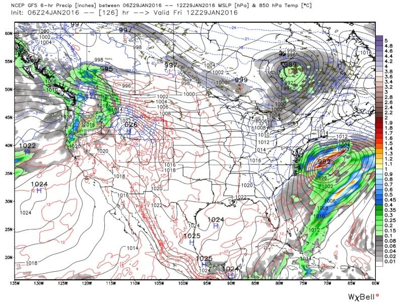
Good morning. A quick update on the next threat around the 29th. Im sure Frank will have a more detailed update.
By looking at the surface maps of the global models alone one might think hey this is really close to something big again.
GFS:

 " />
" />
CMC:

Euro:

 " />
" />
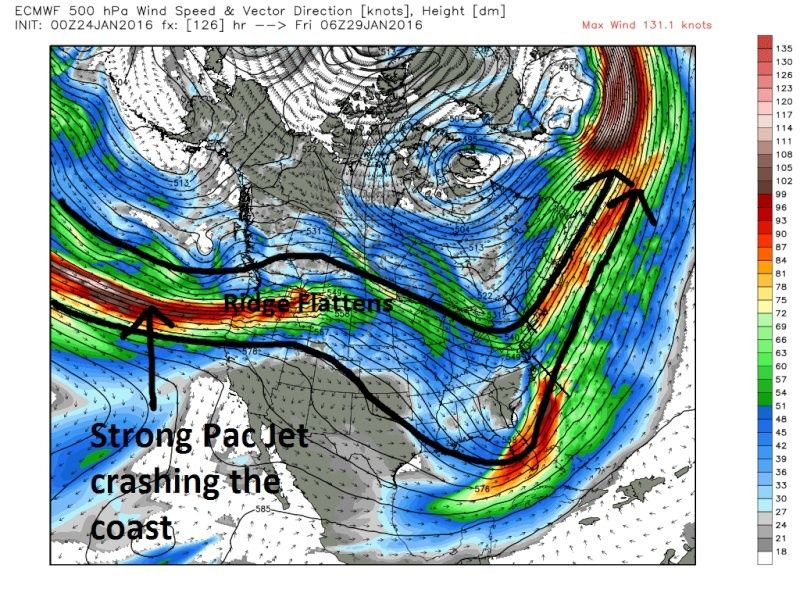
Lets look at 500mb and the overall set up/pattern. I will use the Euro to illustrate my points. Here is the 500mb flow by Thursday 00z. Notice there is some ridging, but also notice the strong Pac jet poking into the left side of the picture (black arrow).

Here is the same time frame; also 500mb, but shows the energy/vorticity associated with the northern and southern jets.

 " />
" />
Fast forward to 06z Friday the 29th. Again 500mb: Notice how the strong Pac Jet crashes the west coast and flattens out our ridge and we do not get a phase of N and S jets.

 " />
" />

Here is the surface map again from above, the same time as the 500mb above (hr126 06z Friday) followed by the next frame: The LP is centered just off Va. The ridge collapsing leads to a progressive flow off our coast and the OTS soln shown on models.

 " />
" />

 " />
" />
What do we need to help.
1) We have to see the western ridge trend stronger and hold on longer. This is the single most important key. Hopefully the Pac jet trends weaker and slower with its timing into the west coast.
Unlike Jonas it doesnt appear that we will have the same blocking in the N Atlantic with this next system. Here is the Atlantic pattern at initialization overnight. The trough in the N Atlantic acted as our block. This was why Jonas was as long a duration as he was. Go back to the 500mb maps above and look at the flow in the N Atlantic...big difference.

There are still differences (timing, strength, placement) in the handling of the 500mb energies involved in this system. That said as of now the pattern does not look to support another storm to come up the coast based on how the models look verbatim. There is not a whole lot of time for things to change, HOWEVER, as the last week has proven we have seen weirder things happen right?
By looking at the surface maps of the global models alone one might think hey this is really close to something big again.
GFS:
 " />
" />CMC:

Euro:
 " />
" />Lets look at 500mb and the overall set up/pattern. I will use the Euro to illustrate my points. Here is the 500mb flow by Thursday 00z. Notice there is some ridging, but also notice the strong Pac jet poking into the left side of the picture (black arrow).

Here is the same time frame; also 500mb, but shows the energy/vorticity associated with the northern and southern jets.
 " />
" />Fast forward to 06z Friday the 29th. Again 500mb: Notice how the strong Pac Jet crashes the west coast and flattens out our ridge and we do not get a phase of N and S jets.
 " />
" />
Here is the surface map again from above, the same time as the 500mb above (hr126 06z Friday) followed by the next frame: The LP is centered just off Va. The ridge collapsing leads to a progressive flow off our coast and the OTS soln shown on models.
 " />
" /> " />
" /> What do we need to help.
1) We have to see the western ridge trend stronger and hold on longer. This is the single most important key. Hopefully the Pac jet trends weaker and slower with its timing into the west coast.
Unlike Jonas it doesnt appear that we will have the same blocking in the N Atlantic with this next system. Here is the Atlantic pattern at initialization overnight. The trough in the N Atlantic acted as our block. This was why Jonas was as long a duration as he was. Go back to the 500mb maps above and look at the flow in the N Atlantic...big difference.

There are still differences (timing, strength, placement) in the handling of the 500mb energies involved in this system. That said as of now the pattern does not look to support another storm to come up the coast based on how the models look verbatim. There is not a whole lot of time for things to change, HOWEVER, as the last week has proven we have seen weirder things happen right?
_________________
"In weather and in life, there's no winning and losing; there's only winning and learning."
WINTER 2012/2013 TOTALS 43.65"WINTER 2017/2018 TOTALS 62.85" WINTER 2022/2023 TOTALS 4.9"
WINTER 2013/2014 TOTALS 64.85"WINTER 2018/2019 TOTALS 14.25" WINTER 2023/2024 TOTALS 13.1"
WINTER 2014/2015 TOTALS 71.20"WINTER 2019/2020 TOTALS 6.35" WINTER 2024/2025 TOTALS 0.00
WINTER 2015/2016 TOTALS 35.00"WINTER 2020/2021 TOTALS 37.75"
WINTER 2016/2017 TOTALS 42.25"WINTER 2021/2022 TOTALS 31.65"

sroc4- Admin

- Posts : 8458
Reputation : 302
Join date : 2013-01-07
Location : Wading River, LI
 Re: Long Range Thread 9.0
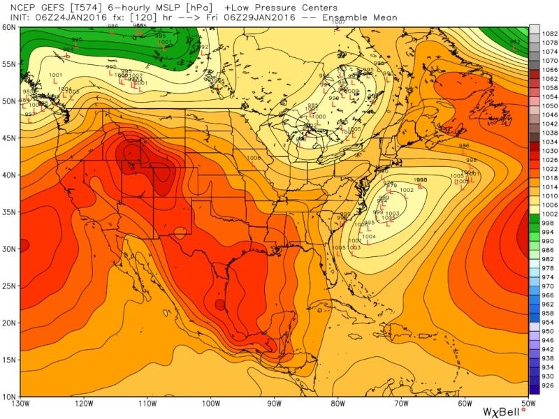
A quick word on the ensembles: You can see by the ens mean it is SE and OTS and the majority of the members lean that way; however, there some members further N and W. Well see.
EPS:
[img] [/img]
GEFS:
EPS:
[img]
 [/img]
GEFS:

_________________
"In weather and in life, there's no winning and losing; there's only winning and learning."
WINTER 2012/2013 TOTALS 43.65"WINTER 2017/2018 TOTALS 62.85" WINTER 2022/2023 TOTALS 4.9"
WINTER 2013/2014 TOTALS 64.85"WINTER 2018/2019 TOTALS 14.25" WINTER 2023/2024 TOTALS 13.1"
WINTER 2014/2015 TOTALS 71.20"WINTER 2019/2020 TOTALS 6.35" WINTER 2024/2025 TOTALS 0.00
WINTER 2015/2016 TOTALS 35.00"WINTER 2020/2021 TOTALS 37.75"
WINTER 2016/2017 TOTALS 42.25"WINTER 2021/2022 TOTALS 31.65"

sroc4- Admin

- Posts : 8458
Reputation : 302
Join date : 2013-01-07
Location : Wading River, LI
 Re: Long Range Thread 9.0
Great write up Sroc.................

Joe Snow- Pro Enthusiast

- Posts : 933
Reputation : 7
Join date : 2014-02-12
Age : 62
Location : Sanford Florida, Fmrly Kings Park, NY
 Re: Long Range Thread 9.0
A couple questions going forward I remember reading on here that February could be great with snow and storms and that the end of January was the teansiton period to a better locked in pattern come Feb. Is this still the thought. Because inhale heard it looks warm going into Feb. Amugs I believe you thought it looked good Frank as well I believe any input.

skinsfan1177- Senior Enthusiast

- Posts : 4485
Reputation : 35
Join date : 2013-01-07
Age : 47
Location : Point Pleasant Boro
 Re: Long Range Thread 9.0
FWIW GFS trending better with the western ridge. Notice how the N energy is digging much deeper on todays 12z vs last nights 00z as a result of the ridge holding stronger a little longer. You can see the southern stream clearly out ahead of the northern stream on both maps. Keep in mind the GFS has a known progressive bias with the southern stream so this actually looks pretty good to me despite the fact that the surface map doesn't look close. baby steps. Long way to go.
00z Last night valid 00z Jan 29th:

12z Today valid same time frame:

00z Last night valid 00z Jan 29th:

12z Today valid same time frame:

_________________
"In weather and in life, there's no winning and losing; there's only winning and learning."
WINTER 2012/2013 TOTALS 43.65"WINTER 2017/2018 TOTALS 62.85" WINTER 2022/2023 TOTALS 4.9"
WINTER 2013/2014 TOTALS 64.85"WINTER 2018/2019 TOTALS 14.25" WINTER 2023/2024 TOTALS 13.1"
WINTER 2014/2015 TOTALS 71.20"WINTER 2019/2020 TOTALS 6.35" WINTER 2024/2025 TOTALS 0.00
WINTER 2015/2016 TOTALS 35.00"WINTER 2020/2021 TOTALS 37.75"
WINTER 2016/2017 TOTALS 42.25"WINTER 2021/2022 TOTALS 31.65"

sroc4- Admin

- Posts : 8458
Reputation : 302
Join date : 2013-01-07
Location : Wading River, LI
 Re: Long Range Thread 9.0
skinsfan1177 wrote:A couple questions going forward I remember reading on here that February could be great with snow and storms and that the end of January was the teansiton period to a better locked in pattern come Feb. Is this still the thought. Because inhale heard it looks warm going into Feb. Amugs I believe you thought it looked good Frank as well I believe any input.
Skins after the 28th-30th threat there will most likely be a warm up of above normal temps in the east, but it looks to only last for about 5-7days, in my eyes, before we return back to a much more favorable pattern for cold and snow. If we can maintain a fairly solid snow pack with the most recent and or next weeks storm the warm up may be muted somewhat. Ill see what kind of write up on the LR Frank does on it. If he doesn't go much into it I might give it a go on Tuesday.
_________________
"In weather and in life, there's no winning and losing; there's only winning and learning."
WINTER 2012/2013 TOTALS 43.65"WINTER 2017/2018 TOTALS 62.85" WINTER 2022/2023 TOTALS 4.9"
WINTER 2013/2014 TOTALS 64.85"WINTER 2018/2019 TOTALS 14.25" WINTER 2023/2024 TOTALS 13.1"
WINTER 2014/2015 TOTALS 71.20"WINTER 2019/2020 TOTALS 6.35" WINTER 2024/2025 TOTALS 0.00
WINTER 2015/2016 TOTALS 35.00"WINTER 2020/2021 TOTALS 37.75"
WINTER 2016/2017 TOTALS 42.25"WINTER 2021/2022 TOTALS 31.65"

sroc4- Admin

- Posts : 8458
Reputation : 302
Join date : 2013-01-07
Location : Wading River, LI
 Re: Long Range Thread 9.0
Thanks sroc always look forward to your insight.sroc4 wrote:skinsfan1177 wrote:A couple questions going forward I remember reading on here that February could be great with snow and storms and that the end of January was the teansiton period to a better locked in pattern come Feb. Is this still the thought. Because inhale heard it looks warm going into Feb. Amugs I believe you thought it looked good Frank as well I believe any input.
Skins after the 28th-30th threat there will most likely be a warm up of above normal temps in the east, but it looks to only last for about 5-7days, in my eyes, before we return back to a much more favorable pattern for cold and snow. If we can maintain a fairly solid snow pack with the most recent and or next weeks storm the warm up may be muted somewhat. Ill see what kind of write up on the LR Frank does on it. If he doesn't go much into it I might give it a go on Tuesday.

skinsfan1177- Senior Enthusiast

- Posts : 4485
Reputation : 35
Join date : 2013-01-07
Age : 47
Location : Point Pleasant Boro
 Re: Long Range Thread 9.0
PJoe Bastardi sees a another storm The caraidian shows out in 138 hrs
frank 638- Senior Enthusiast

- Posts : 2882
Reputation : 37
Join date : 2016-01-01
Age : 41
Location : bronx ny
 Re: Long Range Thread 9.0
scott nice write up. I will wait until this storm is in the nam's range before I believe it or not.lol

algae888- Advanced Forecaster

- Posts : 5311
Reputation : 46
Join date : 2013-02-05
Age : 62
Location : mt. vernon, new york
 Re: Long Range Thread 9.0
there is a possible storm signal for the 29/30th?...have a concert to go to that was cancelled once before..I hope the storm is the 29th if we are having one!!

weatherwatchermom- Senior Enthusiast

- Posts : 3895
Reputation : 78
Join date : 2014-11-25
Location : Hazlet Township, NJ
 Re: Long Range Thread 9.0
It's all about the pna peeps if we get can that to hold or pump we r good if not she goes ots and is a fish storm.
Sroc great analysis as usual.
Sroc great analysis as usual.
_________________
Mugs
AKA:King: Snow Weenie
Self Proclaimed
WINTER 2014-15 : 55.12" +.02 for 6 coatings (avg. 35")
WINTER 2015-16 Total - 29.8" (Avg 35")
WINTER 2016-17 : 39.5" so far

amugs- Advanced Forecaster - Mod

- Posts : 15156
Reputation : 213
Join date : 2013-01-07
Age : 54
Location : Hillsdale,NJ
 Re: Long Range Thread 9.0
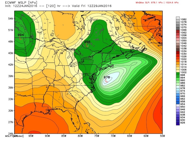
12z EURO paints a more interesting picture for Fri-Sat, H5 almost a phase, looking closer to its ensembles


SoulSingMG- Senior Enthusiast

- Posts : 2853
Reputation : 74
Join date : 2013-12-11
Location : Long Island City, NY
 Re: Long Range Thread 9.0
Scott is right. The western ridge is very important in this case because it's a Miller A setup. Our most recent Roidzilla was Miller C - a phase already happened in the mid section of the country. With Miller A (this event) the phase happens along the east coast. If the northern energy phases with the southern energy there will be another Godzilla to track. I haven't look at this in depth yet. I'll have a Mo Mo for tomorrow.
_________________
_______________________________________________________________________________________________________
CLICK HERE to view NJ Strong Snowstorm Classifications
 Re: Long Range Thread 9.0
CooL is right...models are not far off from showing another significant event. The recent Roidzilla was a Miller C with a rolling +PNA ridge and Atlantic blocking in the form of a huge trough in the NATL. This event features a +PNA ridge bridging with a -AO ridge. As long as the ULL in the NPAC does not eject s/w energy crashing into the west coast to flatten the ridge I kind of like the potential. The blocking is not as good as the Roidzilla but we've gotten Miller A's before without a -NAO. It's all timing related with the western ridge and southern and northern s/w energies.


_________________
_______________________________________________________________________________________________________
CLICK HERE to view NJ Strong Snowstorm Classifications
 Re: Long Range Thread 9.0
This has to at least raise an eyebrow


_________________
_______________________________________________________________________________________________________
CLICK HERE to view NJ Strong Snowstorm Classifications
 Re: Long Range Thread 9.0
Wow EURO ENSEMBLES!!!!!!!!!


_________________
_______________________________________________________________________________________________________
CLICK HERE to view NJ Strong Snowstorm Classifications
Page 31 of 40 •  1 ... 17 ... 30, 31, 32 ... 35 ... 40
Page 31 of 40
Permissions in this forum:
You cannot reply to topics in this forum
 Home
Home
