June 2016 Observations & Discussions
+22
SNOW MAN
essexcountypete
rb924119
ak926
weatherwatchermom
Snow88
Quietace
algae888
Radz
nutleyblizzard
1190ftalt
snow247
Fededle22
Dtone
Dunnzoo
jmanley32
frank 638
RJB8525
skinsfan1177
Frank_Wx
amugs
Math23x7
26 posters
Page 1 of 10
Page 1 of 10 • 1, 2, 3, 4, 5, 6, 7, 8, 9, 10 
 June 2016 Observations & Discussions
The stretch of nice weather we saw to conclude May will continue to start June. Changes are on the horizon though. As it states above, next week should feature a bit of a cool down.
Math23x7- Wx Statistician Guru

- Posts : 2382
Reputation : 68
Join date : 2013-01-08
 Re: June 2016 Observations & Discussions
WOW - where again as this in Dec or even Feb - woudl have been a beaut BUT....


_________________
Mugs
AKA:King: Snow Weenie
Self Proclaimed
WINTER 2014-15 : 55.12" +.02 for 6 coatings (avg. 35")
WINTER 2015-16 Total - 29.8" (Avg 35")
WINTER 2016-17 : 39.5" so far

amugs- Advanced Forecaster - Mod

- Posts : 15156
Reputation : 213
Join date : 2013-01-07
Age : 54
Location : Hillsdale,NJ
 Re: June 2016 Observations & Discussions
Monday blues here - could be some severe action with this set up


_________________
Mugs
AKA:King: Snow Weenie
Self Proclaimed
WINTER 2014-15 : 55.12" +.02 for 6 coatings (avg. 35")
WINTER 2015-16 Total - 29.8" (Avg 35")
WINTER 2016-17 : 39.5" so far

amugs- Advanced Forecaster - Mod

- Posts : 15156
Reputation : 213
Join date : 2013-01-07
Age : 54
Location : Hillsdale,NJ
 Re: June 2016 Observations & Discussions
Okay the GEFS build in a trough from the midwest this weekend through next weekend and relaxes but only to Normal and then the 15th it tries to build in another trough - interesting - I am assuming this is in response to the IO Dipole crash along with SOI in conjunction with teh transition from Nino to Nina and the off the charts PDO
Indian Ocean Dipole - Look at how this was in our winter - uggh!!

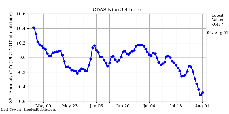
Nino
3.4 - La Nada or Nuetral heading down under

4 ditto

1.2 down again

[img][url=https://servimg.com/view/18554455/57 [/url][/img]
Look at the PDO - line along teh west coast and slopes back towards the Nina cold blue finger.
PNA spike in the west causes the trough the east

it doesn't want to leave

EPO goes big time positive again and the NAO is very Neg here - lots of blockiness

So what does this spell ??
Cool and Wet in the NE
Indian Ocean Dipole - Look at how this was in our winter - uggh!!

Nino
3.4 - La Nada or Nuetral heading down under

4 ditto

1.2 down again

[img][url=https://servimg.com/view/18554455/57
 [/url][/img]
 Look at the PDO - line along teh west coast and slopes back towards the Nina cold blue finger.
PNA spike in the west causes the trough the east

it doesn't want to leave

EPO goes big time positive again and the NAO is very Neg here - lots of blockiness

So what does this spell ??
Cool and Wet in the NE
_________________
Mugs
AKA:King: Snow Weenie
Self Proclaimed
WINTER 2014-15 : 55.12" +.02 for 6 coatings (avg. 35")
WINTER 2015-16 Total - 29.8" (Avg 35")
WINTER 2016-17 : 39.5" so far

amugs- Advanced Forecaster - Mod

- Posts : 15156
Reputation : 213
Join date : 2013-01-07
Age : 54
Location : Hillsdale,NJ
 Re: June 2016 Observations & Discussions
Some rain showers tomorrow morning into mid afternoon. Will clear out by evening.


_________________
_______________________________________________________________________________________________________
CLICK HERE to view NJ Strong Snowstorm Classifications
 Re: June 2016 Observations & Discussions
Sunday into early Monday looks especially unsettled. Around 1 inch of rain possible. Can't rule out a spotty shower on Saturday either. A "meh" weekend on tap.
_________________
_______________________________________________________________________________________________________
CLICK HERE to view NJ Strong Snowstorm Classifications
 Re: June 2016 Observations & Discussions
4k NAM soaks NNJ sat night to Sunday morning


_________________
Mugs
AKA:King: Snow Weenie
Self Proclaimed
WINTER 2014-15 : 55.12" +.02 for 6 coatings (avg. 35")
WINTER 2015-16 Total - 29.8" (Avg 35")
WINTER 2016-17 : 39.5" so far

amugs- Advanced Forecaster - Mod

- Posts : 15156
Reputation : 213
Join date : 2013-01-07
Age : 54
Location : Hillsdale,NJ
 Re: June 2016 Observations & Discussions
amugs wrote:4k NAM soaks NNJ sat night to Sunday morning
C'mon mugs, you know that band of heavy rain will trend #southandeast!
Math23x7- Wx Statistician Guru

- Posts : 2382
Reputation : 68
Join date : 2013-01-08
 Re: June 2016 Observations & Discussions
Sunday potential for severe weather.

skinsfan1177- Senior Enthusiast

- Posts : 4485
Reputation : 35
Join date : 2013-01-07
Age : 47
Location : Point Pleasant Boro
 Re: June 2016 Observations & Discussions
at least memorial day weekend was nice? paying the price now lol. Crappy temps and crappy weather
64* overcast.
64* overcast.

RJB8525- Senior Enthusiast

- Posts : 1994
Reputation : 28
Join date : 2013-02-06
Age : 38
Location : Hackettstown, NJ
 Re: June 2016 Observations & Discussions
skinsfan1177 wrote:Sunday potential for severe weather.
I'm not that impressed. I think there will be storms but not sold on severity
_________________
_______________________________________________________________________________________________________
CLICK HERE to view NJ Strong Snowstorm Classifications
 Re: June 2016 Observations & Discussions
71 deg and cloudy had some light rain before nothing crazy just a crappy day at least tom it will be nice
frank 638- Senior Enthusiast

- Posts : 2882
Reputation : 37
Join date : 2016-01-01
Age : 41
Location : bronx ny
 Re: June 2016 Observations & Discussions

It has pushed northward some

skinsfan1177- Senior Enthusiast

- Posts : 4485
Reputation : 35
Join date : 2013-01-07
Age : 47
Location : Point Pleasant Boro
 Re: June 2016 Observations & Discussions
Even though I believe there will be a Tornado watch for teh areas S & W of the NYC Metro area the HRRR and Hi Res NAM are showing a strong line of severe storms that may impact our area with teh warm front. It is going to be interesting as the days goes on today but check out the latest loop of the HRRR - pretty impressive.
The PWATS for teh area are high but not as high as the SNJ, MD, DE and SPA areas.
http://rapidrefresh.noaa.gov/HRRR/jsloopLocalDiskDateDomainZipTZA.cgi?dsKeys=hrrr_jet:&runTime=2016060412&plotName=cref_t3sfc&fcstInc=60&numFcsts=37&model=hrrr&ptitle=HRRR%20Model%20Fields%20-%20Experimental&maxFcstLen=36&fcstStrLen=-1&resizePlot=1&domain=t3
_________________
Mugs
AKA:King: Snow Weenie
Self Proclaimed
WINTER 2014-15 : 55.12" +.02 for 6 coatings (avg. 35")
WINTER 2015-16 Total - 29.8" (Avg 35")
WINTER 2016-17 : 39.5" so far

amugs- Advanced Forecaster - Mod

- Posts : 15156
Reputation : 213
Join date : 2013-01-07
Age : 54
Location : Hillsdale,NJ
 Re: June 2016 Observations & Discussions
Wow what a big difference from yesterday's weather to today it's humid and muggy I hope we have good t storms tom
frank 638- Senior Enthusiast

- Posts : 2882
Reputation : 37
Join date : 2016-01-01
Age : 41
Location : bronx ny
 Re: June 2016 Observations & Discussions
Theirs a good chance we willfrank 638 wrote:Wow what a big difference from yesterday's weather to today it's humid and muggy I hope we have good t storms tom

skinsfan1177- Senior Enthusiast

- Posts : 4485
Reputation : 35
Join date : 2013-01-07
Age : 47
Location : Point Pleasant Boro
 Re: June 2016 Observations & Discussions
does anyone know what time we will see showers and thunderstorms
frank 638- Senior Enthusiast

- Posts : 2882
Reputation : 37
Join date : 2016-01-01
Age : 41
Location : bronx ny
 Re: June 2016 Observations & Discussions
The SPC pushed the yellow and orange even more north.


jmanley32- Senior Enthusiast

- Posts : 20646
Reputation : 108
Join date : 2013-12-12
Age : 43
Location : Yonkers, NY
 Re: June 2016 Observations & Discussions
amugs wrote:Even though I believe there will be a Tornado watch for teh areas S & W of the NYC Metro area the HRRR and Hi Res NAM are showing a strong line of severe storms that may impact our area with teh warm front. It is going to be interesting as the days goes on today but check out the latest loop of the HRRR - pretty impressive.
The PWATS for teh area are high but not as high as the SNJ, MD, DE and SPA areas.
http://rapidrefresh.noaa.gov/HRRR/jsloopLocalDiskDateDomainZipTZA.cgi?dsKeys=hrrr_jet:&runTime=2016060412&plotName=cref_t3sfc&fcstInc=60&numFcsts=37&model=hrrr&ptitle=HRRR%20Model%20Fields%20-%20Experimental&maxFcstLen=36&fcstStrLen=-1&resizePlot=1&domain=t3
I wouldnt be surprised to see most of the area under a svr t-storm watch or tornado watch tomorrow later. Though looks by HRRR there may be some less strong storms earlier in the day so is the day pretty much a washout?

jmanley32- Senior Enthusiast

- Posts : 20646
Reputation : 108
Join date : 2013-12-12
Age : 43
Location : Yonkers, NY
 Re: June 2016 Observations & Discussions
Rain expected most of the day tomorrow. Looks like SPC still believes in the severe weather threat. I felt there will be too many clouds around that would keep the airmass too stable. We'll see....
_________________
_______________________________________________________________________________________________________
CLICK HERE to view NJ Strong Snowstorm Classifications
 Re: June 2016 Observations & Discussions
Hey Frank I am not that savy on the technical discussions by spc as the words they use are not english lol, but it seems they think there will be enough instability without a lot of sun heating.

jmanley32- Senior Enthusiast

- Posts : 20646
Reputation : 108
Join date : 2013-12-12
Age : 43
Location : Yonkers, NY
 Re: June 2016 Observations & Discussions
Math23x7 wrote:amugs wrote:4k NAM soaks NNJ sat night to Sunday morning
C'mon mugs, you know that band of heavy rain will trend #southandeast!
I like the little rainband circles from bonnie down by carolinas that looks cool. That tiny rain band is rather odd.

jmanley32- Senior Enthusiast

- Posts : 20646
Reputation : 108
Join date : 2013-12-12
Age : 43
Location : Yonkers, NY

skinsfan1177- Senior Enthusiast

- Posts : 4485
Reputation : 35
Join date : 2013-01-07
Age : 47
Location : Point Pleasant Boro
 Re: June 2016 Observations & Discussions
We may get a break for a few hours late morning, early afternoon before the front comes through late tomorrow. Looks like it will come through NNJ about 9-10 pm.
_________________
Janet
Snowfall winter of 2023-2024 17.5"
Snowfall winter of 2022-2023 6.0"
Snowfall winter of 2021-2022 17.6" 1" sleet 2/25/22
Snowfall winter of 2020-2021 51.1"
Snowfall winter of 2019-2020 8.5"
Snowfall winter of 2018-2019 25.1"
Snowfall winter of 2017-2018 51.9"
Snowfall winter of 2016-2017 45.6"
Snowfall winter of 2015-2016 29.5"
Snowfall winter of 2014-2015 50.55"
Snowfall winter of 2013-2014 66.5"

Dunnzoo- Senior Enthusiast - Mod

- Posts : 4937
Reputation : 68
Join date : 2013-01-11
Age : 62
Location : Westwood, NJ
 Re: June 2016 Observations & Discussions
Its pouring.
been raining on and off for a few hrs now its really coming down. I didnt expect so much rain so early.
been raining on and off for a few hrs now its really coming down. I didnt expect so much rain so early.
Dtone- Wx Statistician Guru

- Posts : 1738
Reputation : 9
Join date : 2013-08-26
Location : Bronx, NY
Page 1 of 10 • 1, 2, 3, 4, 5, 6, 7, 8, 9, 10 
Page 1 of 10
Permissions in this forum:
You cannot reply to topics in this forum
 Home
Home
