Long Range Thread 12.0
+30
StatenWx
Dunnzoo
weatherwatchermom
Quietace
dkodgis
mwilli5783
jrollins628
devsman
skinsfan1177
billg315
jmanley32
Snow88
chief7
Dtone
Isotherm
sroc4
docstox12
CPcantmeasuresnow
frank 638
track17
NjWeatherGuy
HectorO
SNOW MAN
rb924119
Math23x7
algae888
snow247
amugs
nutleyblizzard
Frank_Wx
34 posters
Page 5 of 40
Page 5 of 40 •  1, 2, 3, 4, 5, 6 ... 22 ... 40
 Re: Long Range Thread 12.0
Almanac has been decent for the past few years but just bought this years for the crap of it and forecast looks unusually bad. Calling for below normal November I think by a degree, and very warm December averaging warmer than November by a degree departing 6 degrees above normal! For most of us theyre predicting "above normal snowfall north (new england, boston) below normal central (us), near normal south, above average precipitation north, near normal south. I believe they call for January-Mar to be the coldest and snowiest (not surprising) but not sure I agree with a warmer December than November but we'll see.
NjWeatherGuy- Advanced Forecaster

- Posts : 4100
Join date : 2013-01-06
 Re: Long Range Thread 12.0
SST Anomaly change

Look st the subsurface - not that cool
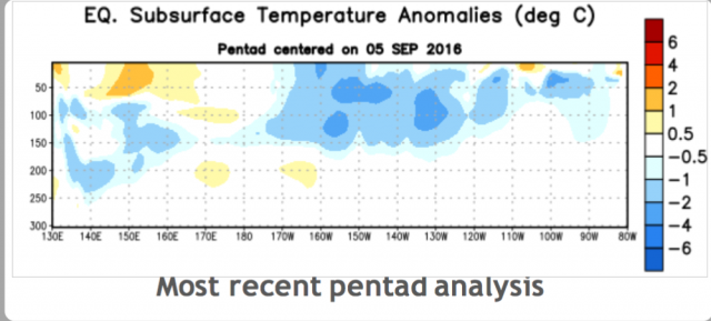
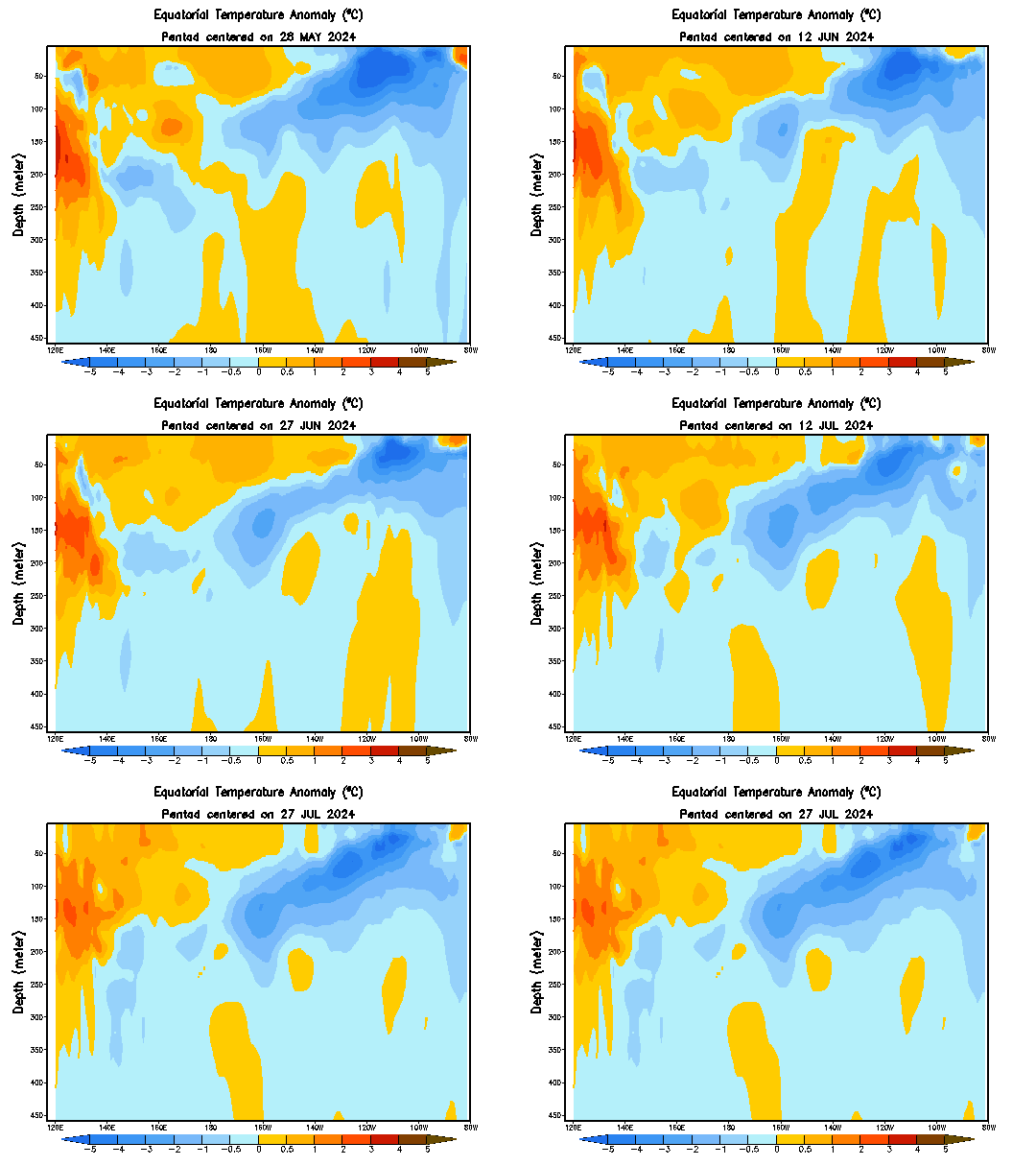
This is subsiding by my eye and the SOI is I would say in response to some other weather event - read that seasonal pressure changes in this SPAC region ten to cause these Rosby Waves to occur - could be wrong but time will tell.
Lets compare this years blob
currrent
.png)
to 2014-15 Winter season
.png)
Lets hope it holds and deepens as we move through the fall - no upwelling by recurving typhoons please!!
JB posted this 500mb CFSv2
.png)

Look st the subsurface - not that cool


This is subsiding by my eye and the SOI is I would say in response to some other weather event - read that seasonal pressure changes in this SPAC region ten to cause these Rosby Waves to occur - could be wrong but time will tell.
Lets compare this years blob
currrent
.png)
to 2014-15 Winter season
.png)
Lets hope it holds and deepens as we move through the fall - no upwelling by recurving typhoons please!!
JB posted this 500mb CFSv2
.png)
amugs- Advanced Forecaster - Mod

- Posts : 15157
Join date : 2013-01-07
 Re: Long Range Thread 12.0
amugs wrote:SST Anomaly change
Look st the subsurface - not that cool
This is subsiding by my eye and the SOI is I would say in response to some other weather event - read that seasonal pressure changes in this SPAC region ten to cause these Rosby Waves to occur - could be wrong but time will tell.
Lets compare this years blob
currrent
to 2014-15 Winter season
Lets hope it holds and deepens as we move through the fall - no upwelling by recurving typhoons please!!
JB posted this 500mb CFSv2
I would expect at least a weak Nina by technicality to hold thru the early part of the winter, after which we may see a hover around neutral to a slight trend to Nino positive by the latter part but very very weak, would not make much of a difference IMHO, other factors will be the main drivers of our pattern. Such as the PDO and NAO and what MJO pattern sets up but all of which will be determined as we get closer. As is life, we will have to wait and see.
NjWeatherGuy- Advanced Forecaster

- Posts : 4100
Reputation : 28
Join date : 2013-01-06
Location : Belle Mead, NJ
 Re: Long Range Thread 12.0
sroc4 wrote:track17 wrote:Can someone translate this. Does this mean we are going to have a bad winter now with little snow? Please explain
Track...These statements alone cannot be translated yet into what it means for our upcoming winter. In general when you see the SOI increase as it is currently, and forecast to do over most of the this month it typicaly means a stronger easterly(coming from the east moving west) component to the winds over the Tropical Pac. Picture the Tropical Pac like a big bath tub with the western side where the warm water is running. In general the western Trop Pac has warmer water temps than the eastern half.
Now picture you have a giant Fan blowing over the surface of the bathtub(Trop Pac). If the Fan is placed on the western side (westerly winds) faceing east towards the Americas then you might visualize the warmer waters being pushed east. If those westerly winds persist long enough(which will often times be seen when the SOI is strongly negative) and strong enough, then the warmer western Pac ends up mixing with the cooler waters to the east warming them to above normal temps relative to average....El Nino conditions. Currently the SOi is such that Easterly winds are predicted to be anomalously strong over the next month. Place the Fan on the eatern side of the Pac and push the warmer waters back west and aloww the cooler sub surface waters to rise to replace the water being pushed west cooling the Trop Pac...La Nina conditions. Of course this is very simply put but the overall idea is there.
In general the Trop Pac, because its such a huge body of water relative to the rest of the globe, plays one of the most important roles in setting up the pattern going into winter months; however, its not the only piece to the puzzle. This discussion is simply monitoring one parameter that will influence the outcome of the winter. Patience for now is needed as we still have a few more months to see where all the different drivers to the weather system, Trop Pacific, indian ocean, Northern Pac, Atlantic SST, snow cover in Siberia, stratosphere to name but a few) set up before making predictions on how the winter unfolds in a specific region.
Nice post and good explanation.
Another way I'd differentiate it that La Nina is essentially an amplification of typical conditions (enhanced easterly trades) while, conversely, El Nino is a deceleration of typical conditions or sometimes complete reversal (particularly like last winter, when we witnessed innumerable robust WLY wind bursts). The thermocline is more (less) steep in a La Nina (El Nino) given the tendency for a greater (lesser) depth of warm water in the eastern Pacific in a El Nino (La Nina).
There is a very potent ELY wind burst forecasted over the next week, which should be the strongest thus far in this -ENSO event. It will be interesting to see the extent to which sea surface temperatures respond in the subsequent weeks. My guess is we probably do manage to reach the weak La Nina threshold, at least for a few months (possibly through winter).

 Re: Long Range Thread 12.0
Isotherm wrote:sroc4 wrote:track17 wrote:Can someone translate this. Does this mean we are going to have a bad winter now with little snow? Please explain
Track...These statements alone cannot be translated yet into what it means for our upcoming winter. In general when you see the SOI increase as it is currently, and forecast to do over most of the this month it typicaly means a stronger easterly(coming from the east moving west) component to the winds over the Tropical Pac. Picture the Tropical Pac like a big bath tub with the western side where the warm water is running. In general the western Trop Pac has warmer water temps than the eastern half.
Now picture you have a giant Fan blowing over the surface of the bathtub(Trop Pac). If the Fan is placed on the western side (westerly winds) faceing east towards the Americas then you might visualize the warmer waters being pushed east. If those westerly winds persist long enough(which will often times be seen when the SOI is strongly negative) and strong enough, then the warmer western Pac ends up mixing with the cooler waters to the east warming them to above normal temps relative to average....El Nino conditions. Currently the SOi is such that Easterly winds are predicted to be anomalously strong over the next month. Place the Fan on the eatern side of the Pac and push the warmer waters back west and aloww the cooler sub surface waters to rise to replace the water being pushed west cooling the Trop Pac...La Nina conditions. Of course this is very simply put but the overall idea is there.
In general the Trop Pac, because its such a huge body of water relative to the rest of the globe, plays one of the most important roles in setting up the pattern going into winter months; however, its not the only piece to the puzzle. This discussion is simply monitoring one parameter that will influence the outcome of the winter. Patience for now is needed as we still have a few more months to see where all the different drivers to the weather system, Trop Pacific, indian ocean, Northern Pac, Atlantic SST, snow cover in Siberia, stratosphere to name but a few) set up before making predictions on how the winter unfolds in a specific region.
Nice post and good explanation.
Another way I'd differentiate it that La Nina is essentially an amplification of typical conditions (enhanced easterly trades) while, conversely, El Nino is a deceleration of typical conditions or sometimes complete reversal (particularly like last winter, when we witnessed innumerable robust WLY wind bursts). The thermocline is more (less) steep in a La Nina (El Nino) given the tendency for a greater (lesser) depth of warm water in the eastern Pacific in a El Nino (La Nina).
There is a very potent ELY wind burst forecasted over the next week, which should be the strongest thus far in this -ENSO event. It will be interesting to see the extent to which sea surface temperatures respond in the subsequent weeks. My guess is we probably do manage to reach the weak La Nina threshold, at least for a few months (possibly through winter).
Thank you. I'm glad to see you back on this site for discussions. I tried to keep things as simple as possible for maximum understanding. Its interesting to me to see many people, meteorologists and weather enthusiast alike, look at this up coming winter relative to ENSO status as so cut and dry or like a switch turning on and off relative to a weak La nina vs a La Nada. Personally unless La Nina develops much stronger than anticipated or if some of the other divers change drastically between now an Nov/Dec, for the most part the overall ENSO influences should be similar regardless of the textbook defintion. In some ways this year may end up similar to winter of 2014/15 when there was the debate about if there was a weak El Nino influence on the atmosphere or not. By the text book the criteria was not met until well into the Spring and summer of 2015 if I'm remembering correctly. That winter had an El Nino leaning La Nada; whereas, this year may have a La Nina leaning La Nada.
Anyway a few years back I would read these types of posts and be like what the fff are they talking about, so I figured Id expand a little on the what the SOI (Southern Oscillation Index) is for some of the lurkers of the forum and try to explain why/how it affects the status of the tropical pacific.
When we talk about the status of any given La Nina, El Nino, or La Nada your actually talking about the "ENSO" status as a whole. ENSO stands for El Nino Southern Oscillation. So in realitiy when defining if the tropical pacific is in a La Nina or El nino phase you must take the actual SST(sea surface temp) deviations into consideration, but also take the southern oscillation as well. So what is the southern oscillation? The Southen Oscillation is kind of like the fan in the analogy I described above. Here is a paragraph copied and pasted from the following website to help explain: https://www.ncdc.noaa.gov/teleconnections/enso/indicators/soi/
The Southern Oscillation Index (SOI) is a standardized index based on the observed sea level pressure differences between Tahiti and Darwin, Australia. The SOI is one measure of the large-scale fluctuations in air pressure occurring between the western and eastern tropical Pacific (i.e., the state of the Southern Oscillation) during El Niño and La Niña episodes. In general, smoothed time series of the SOI correspond very well with changes in ocean temperatures across the eastern tropical Pacific. The negative phase of the SOI represents below-normal air pressure at Tahiti and above-normal air pressure at Darwin. Prolonged periods of negative (positive) SOI values coincide with abnormally warm (cold) ocean waters across the eastern tropical Pacific typical of El Niño (La Niña) episodes.
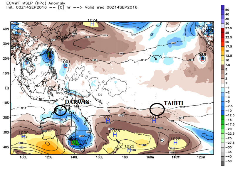
As a general rule to follow is in order to have the SO part of ENSO in a La Nina(El Nino) status the SOI avg 90 day value should be above +8.0 (below -8.0) respectively, with a value between -8.0 and +8.0 characterizing a La Nada. The image above is the Euro MSLP anomaly map from last nights 00z run. You can clearly see that high pressure(HP) dominates Tahiti whereas low pressure LP dominates Darwin. For the next two weeks there is a forecast that will cont to see higher pressures in Tahiti relative to Darwin with fluxuations throughout. As we all know from basic earth science winds flow from areas of HP to areas of LP. That in mind one can clearly visualize the stronger/steeper this gradient between these two locations the stronger and faster these easterly (from east to west) will move. Now refer to the map above that Isotherm posted about the 850h-PA zonal wind anomalies. The purple colors he is referring, and Frank showed a similar map from a diff site but showing the same 850 h-PA zonal wind anomalies, is showing us the stronger than normal easterlies forecasted which is likely in a direct correlation with the pressure differences described above which can also be seen quite nicely by following the SOI as well. Remember the SOI value is a result of these pressure diffences, so by simply following these values over time you can get a broad sense of how strong, which direction, and for how long the zonal winds are moving the waters of the trop Pac around (via the bathtub analogy described above) and thereby giving us a "general" idea of where the SST anomalies are going within the Trop Pac.
Here is the link for the SOI. First row is the daily SOI value; second row is the 30day avg, and third row is the 90avg. This site gives the last 30days of these values.
https://www.longpaddock.qld.gov.au/seasonalclimateoutlook/southernoscillationindex/30daysoivalues/
You can clearly see starting Sept 9th the spike in the SOI and if you look at the 850h-Pa map above correlates nicely with the easterly wind burst being discussed. You can also see the current trend with both the running 30 and 90 day avg. towards La Nina status. Now word of caution. As we head deeper into the fall the natural climo change of seasons will likely put a damper of such strong bursts of easterlies. Like is mentioned above we will have to see what such a strong forecasted easterly wind burst is going to do to the SST as well as the sub surface temps. Even though the current sub surface temps have tempered some over the last month or so......:

It is possible that if there are several more easterly bursts similar or close in magnitude over the next 1-3months that more significant upwelling's could occur. This we will simply have to wait and see how it shakes out. We just don't have good enough modeling to accurately predict how this part of the equation plays out.
So I hope this has given many a little more of an understanding on this part of the ENSO status, so that when Frank and Isotherm and others put out there winter forecasts and you come across their discussions on the status of the ENSO you will actually have an idea what they are talking about.
Isotherm or Frank or anyone else if there are inaccuracies please let me know, so I can clean it up. I may want to archive this discussion in the education section of the board for future reference. Thanks.
Last edited by sroc4 on Fri Sep 16, 2016 6:29 am; edited 1 time in total
_________________
"In weather and in life, there's no winning and losing; there's only winning and learning."
WINTER 2012/2013 TOTALS 43.65"WINTER 2017/2018 TOTALS 62.85" WINTER 2022/2023 TOTALS 4.9"
WINTER 2013/2014 TOTALS 64.85"WINTER 2018/2019 TOTALS 14.25" WINTER 2023/2024 TOTALS 13.1"
WINTER 2014/2015 TOTALS 71.20"WINTER 2019/2020 TOTALS 6.35" WINTER 2024/2025 TOTALS 0.00
WINTER 2015/2016 TOTALS 35.00"WINTER 2020/2021 TOTALS 37.75"
WINTER 2016/2017 TOTALS 42.25"WINTER 2021/2022 TOTALS 31.65"

sroc4- Admin

- Posts : 8458
Reputation : 302
Join date : 2013-01-07
Location : Wading River, LI
 Re: Long Range Thread 12.0
Posted this on USAwx site as well
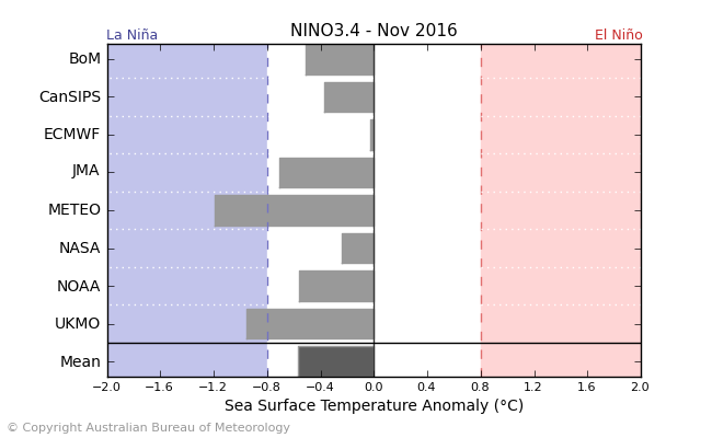

As Tom, Sroc, Frank. Isotherm and Al have been saying here that la Nina is weak at best to neutral.
I am seeing like I said this burst of winds with SOI to be from what I have read a short lived event due to possible seasonal pressure changes in this region of teh SPAC. AS isotherm said it remains to be seen how strong and the effects this will have on SST's in the equatorial region.
JMA OUT from JB SITE - trough in the east - HMMMMM.
.png)


As Tom, Sroc, Frank. Isotherm and Al have been saying here that la Nina is weak at best to neutral.
I am seeing like I said this burst of winds with SOI to be from what I have read a short lived event due to possible seasonal pressure changes in this region of teh SPAC. AS isotherm said it remains to be seen how strong and the effects this will have on SST's in the equatorial region.
JMA OUT from JB SITE - trough in the east - HMMMMM.
.png)
_________________
Mugs
AKA:King: Snow Weenie
Self Proclaimed
WINTER 2014-15 : 55.12" +.02 for 6 coatings (avg. 35")
WINTER 2015-16 Total - 29.8" (Avg 35")
WINTER 2016-17 : 39.5" so far

amugs- Advanced Forecaster - Mod

- Posts : 15157
Reputation : 213
Join date : 2013-01-07
Age : 54
Location : Hillsdale,NJ
 Re: Long Range Thread 12.0
A somewhat controversial thing Ive read about is the AMO, or Atlantic Multidecadal Oscillation which we have been in a long warm phase of, and a cool phase in the 90s, and I am surprised it is not mentioned more given its correlation with Atlantic cyclones. Minor hurricanes are somewhat more frequent in warm phases of the AMO and tropical cyclones that mature into major hurricanes is highly increased during warm phases of the AMO. To sum it up, we got a warm Atlantic this year as we have had the past several, with variation of course. And it may lead to increased EC storms (again, as it has been).
.
.

NjWeatherGuy- Advanced Forecaster

- Posts : 4100
Reputation : 28
Join date : 2013-01-06
Location : Belle Mead, NJ
 Re: Long Range Thread 12.0
Thanks Sroc, good to be back posting here as well. And no - I can't find any flaw in what you've written; very nice explanation about the SOI/ENSO relationship. As an aside (not necessarily related to the coming winter), the next several years are going to be very fascinating for those who have been monitoring the climate variations, especially insofar as revealing - more ostensibly - the relative attribution with respect to the induction of climate changes. Right now, our most similar recent ENSO/Solar cycle couplet is the 1970s. Subsequent to this winter's cold neutral or weak La Nina conditions, I anticipate that La Nina would either maintain its intensity or strengthen to moderate for the subsequent year (2017-18). I expect the positive PDO to reverse to a predominant negative phase in 2017 with potentially three consecutive years of cold ENSO conditions of varying magnitudes. Contemporaneously, the effects of the reduced accumulated solar energy will begin to manifest more strongly as we move forward through 2017-2020, making things more interesting insofar as global temperatures, as I noted in the first sentence. More information will be obtained regarding future attribution studies.
 Re: Long Range Thread 12.0
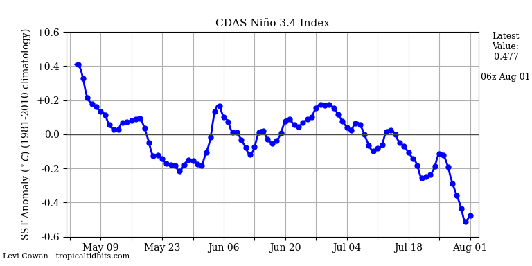
with the easterly wind bursts all nino regions have warmed significantly the last several days as the relatively warm waters in regions 1.2 and 3 expand west westward. cool neutral is becoming more likely with each passing day.



algae888- Advanced Forecaster

- Posts : 5311
Reputation : 46
Join date : 2013-02-05
Age : 62
Location : mt. vernon, new york
 Re: Long Range Thread 12.0
algae888 wrote:with the easterly wind bursts all nino regions have warmed significantly the last several days as the relatively warm waters in regions 1.2 and 3 expand west westward. cool neutral is becoming more likely with each passing day.
Give it time. We aren't even into the meat of this burst yet. The true affects likely won't be seen for a week or two.
_________________
"In weather and in life, there's no winning and losing; there's only winning and learning."
WINTER 2012/2013 TOTALS 43.65"WINTER 2017/2018 TOTALS 62.85" WINTER 2022/2023 TOTALS 4.9"
WINTER 2013/2014 TOTALS 64.85"WINTER 2018/2019 TOTALS 14.25" WINTER 2023/2024 TOTALS 13.1"
WINTER 2014/2015 TOTALS 71.20"WINTER 2019/2020 TOTALS 6.35" WINTER 2024/2025 TOTALS 0.00
WINTER 2015/2016 TOTALS 35.00"WINTER 2020/2021 TOTALS 37.75"
WINTER 2016/2017 TOTALS 42.25"WINTER 2021/2022 TOTALS 31.65"

sroc4- Admin

- Posts : 8458
Reputation : 302
Join date : 2013-01-07
Location : Wading River, LI
 Re: Long Range Thread 12.0
For comparison sake on the JAMSTEC at this time in September predicting the 2m Temps for the D-F time frame


Now look at how it starts to pick up on the +PDO - Blob in the NPAC come NOV


SO my point being it is a bit wacky with the SST maps that it presently has for this type of warmth IMO at this time.
Major shift will be forthcoming if what we see now in the SST holds - IF the operative word.

Also, the PAC is more like a Nino than a Nina with all of the warmth and pockets and slim trails of cool water at the Equator - Look for oneself -= yes we have cooler water off the Cal coast to Baja Mehico - shallow waters of cool and as you go west young man we see warmer waters. Something I stated here before is that we are in the process of a BAD hangover from the super Nino and models. From research I have read it usually takes about 6 months to come out of a strong nino and this one may take a bit longer since it was the strongest on record for modern times. So what does this mean - only time will tell.
Lastly, Bill Goodman from NWS who presented to our NJWO group - weather weenies let's be real here - said they are finding the July NAO correlation to have some validity. he even pointed to teh fact of a young met who is on other boards and goes by the name Earthlight - who has done research and made this point in his predictions - remember last year he said this here?? I do and posted that the NAO was
201507 -3.18
something and guess what suckers - Jan before the great Blizz (for some here)we were about that Negative. He has shown the past 5 years as said this is still in theory idea stage but has some support. So boys what was or NAO reading this summer overall as UNC W posted - Negative
201606 -0.43
201607 -1.76
201608 -1.65
So if this is to be true as well and we hold the warmth in Davis Straits and the cold pool SW of Iceland as Greg (Analog) pointed out from our Bill Goodman presentation then we have the possibility of -NAO west base set up.
This could all got to pot by other variables so it i snot a prediction but just some present data for discussion.


Now look at how it starts to pick up on the +PDO - Blob in the NPAC come NOV


SO my point being it is a bit wacky with the SST maps that it presently has for this type of warmth IMO at this time.
Major shift will be forthcoming if what we see now in the SST holds - IF the operative word.

Also, the PAC is more like a Nino than a Nina with all of the warmth and pockets and slim trails of cool water at the Equator - Look for oneself -= yes we have cooler water off the Cal coast to Baja Mehico - shallow waters of cool and as you go west young man we see warmer waters. Something I stated here before is that we are in the process of a BAD hangover from the super Nino and models. From research I have read it usually takes about 6 months to come out of a strong nino and this one may take a bit longer since it was the strongest on record for modern times. So what does this mean - only time will tell.
Lastly, Bill Goodman from NWS who presented to our NJWO group - weather weenies let's be real here - said they are finding the July NAO correlation to have some validity. he even pointed to teh fact of a young met who is on other boards and goes by the name Earthlight - who has done research and made this point in his predictions - remember last year he said this here?? I do and posted that the NAO was
201507 -3.18
something and guess what suckers - Jan before the great Blizz (for some here)we were about that Negative. He has shown the past 5 years as said this is still in theory idea stage but has some support. So boys what was or NAO reading this summer overall as UNC W posted - Negative
201606 -0.43
201607 -1.76
201608 -1.65
So if this is to be true as well and we hold the warmth in Davis Straits and the cold pool SW of Iceland as Greg (Analog) pointed out from our Bill Goodman presentation then we have the possibility of -NAO west base set up.
This could all got to pot by other variables so it i snot a prediction but just some present data for discussion.
_________________
Mugs
AKA:King: Snow Weenie
Self Proclaimed
WINTER 2014-15 : 55.12" +.02 for 6 coatings (avg. 35")
WINTER 2015-16 Total - 29.8" (Avg 35")
WINTER 2016-17 : 39.5" so far

amugs- Advanced Forecaster - Mod

- Posts : 15157
Reputation : 213
Join date : 2013-01-07
Age : 54
Location : Hillsdale,NJ
 Re: Long Range Thread 12.0
Neutral to slightly cold Nina


_________________
Mugs
AKA:King: Snow Weenie
Self Proclaimed
WINTER 2014-15 : 55.12" +.02 for 6 coatings (avg. 35")
WINTER 2015-16 Total - 29.8" (Avg 35")
WINTER 2016-17 : 39.5" so far

amugs- Advanced Forecaster - Mod

- Posts : 15157
Reputation : 213
Join date : 2013-01-07
Age : 54
Location : Hillsdale,NJ
 Re: Long Range Thread 12.0
Some are hinting at another back loaded winter. I sure hope that's not the case as we always nervously wait for the so called "pattern flip" to take place. We are over due for a start to finish type winter; ala 96 style. A weak Nina gives us the best chance to achieve that as long as the other weather anomalies cooperate like the PDO and NAO.

nutleyblizzard- Senior Enthusiast

- Posts : 1964
Reputation : 41
Join date : 2014-01-30
Age : 58
Location : Nutley, new jersey
 Re: Long Range Thread 12.0
CFS saying weak Niña


_________________
Mugs
AKA:King: Snow Weenie
Self Proclaimed
WINTER 2014-15 : 55.12" +.02 for 6 coatings (avg. 35")
WINTER 2015-16 Total - 29.8" (Avg 35")
WINTER 2016-17 : 39.5" so far

amugs- Advanced Forecaster - Mod

- Posts : 15157
Reputation : 213
Join date : 2013-01-07
Age : 54
Location : Hillsdale,NJ
 Re: Long Range Thread 12.0
That looks more La Nada to me. Above the -0.5 threshold.
_________________
_______________________________________________________________________________________________________
CLICK HERE to view NJ Strong Snowstorm Classifications
 Re: Long Range Thread 12.0
As a preliminary guess for this winter I believe we will go back to the usual climo which favors more snow north and west of I-287. My reasoning is a warm Atlantic a strong Atlantic Ridge a not so positive pdo plus a +Qbo/ low solar which would favor a positive Nao. Storm track will probably be variable this year but most prominently up the spine of the apps or Coastal huggers. I think we will get some good cold shots coming through so above normal snow for all still not out of the question. The no-brainer is above normal Temps but not too far from normal as the planet is just scorching right now. Still enough cold to produce snow but I feel just not below normal

algae888- Advanced Forecaster

- Posts : 5311
Reputation : 46
Join date : 2013-02-05
Age : 62
Location : mt. vernon, new york
 Re: Long Range Thread 12.0
Frank_Wx wrote:That looks more La Nada to me. Above the -0.5 threshold.
That's what I've been hearing lately. La Nina is no longer expected. Netural conditions most likely now
Dtone- Wx Statistician Guru

- Posts : 1738
Reputation : 9
Join date : 2013-08-26
Location : Bronx, NY
 Re: Long Range Thread 12.0
Sea Ice extent - low but making a comeback which is a positive

Snow cover by the end of the month in Siberia grows - another good sign


Snow cover by the end of the month in Siberia grows - another good sign

_________________
Mugs
AKA:King: Snow Weenie
Self Proclaimed
WINTER 2014-15 : 55.12" +.02 for 6 coatings (avg. 35")
WINTER 2015-16 Total - 29.8" (Avg 35")
WINTER 2016-17 : 39.5" so far

amugs- Advanced Forecaster - Mod

- Posts : 15157
Reputation : 213
Join date : 2013-01-07
Age : 54
Location : Hillsdale,NJ
 Re: Long Range Thread 12.0
Growing Season has begun -TIS the SEASON !!!!

Looky see now:


Looky see now:

_________________
Mugs
AKA:King: Snow Weenie
Self Proclaimed
WINTER 2014-15 : 55.12" +.02 for 6 coatings (avg. 35")
WINTER 2015-16 Total - 29.8" (Avg 35")
WINTER 2016-17 : 39.5" so far

amugs- Advanced Forecaster - Mod

- Posts : 15157
Reputation : 213
Join date : 2013-01-07
Age : 54
Location : Hillsdale,NJ
 Re: Long Range Thread 12.0
amugs wrote:Growing Season has begun -TIS the SEASON !!!!
Looky see now:

_________________
"In weather and in life, there's no winning and losing; there's only winning and learning."
WINTER 2012/2013 TOTALS 43.65"WINTER 2017/2018 TOTALS 62.85" WINTER 2022/2023 TOTALS 4.9"
WINTER 2013/2014 TOTALS 64.85"WINTER 2018/2019 TOTALS 14.25" WINTER 2023/2024 TOTALS 13.1"
WINTER 2014/2015 TOTALS 71.20"WINTER 2019/2020 TOTALS 6.35" WINTER 2024/2025 TOTALS 0.00
WINTER 2015/2016 TOTALS 35.00"WINTER 2020/2021 TOTALS 37.75"
WINTER 2016/2017 TOTALS 42.25"WINTER 2021/2022 TOTALS 31.65"

sroc4- Admin

- Posts : 8458
Reputation : 302
Join date : 2013-01-07
Location : Wading River, LI
 Re: Long Range Thread 12.0
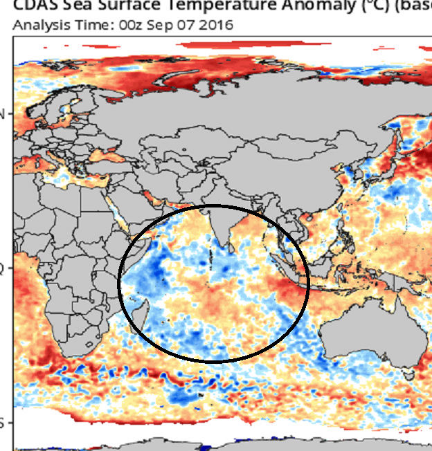
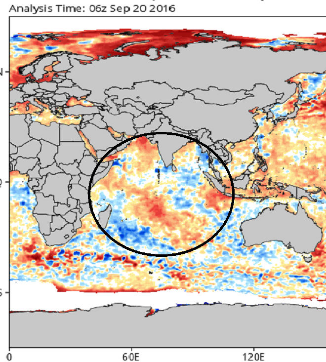
A fair amount of warming has occurred in 2 short week in the Indian Ocean. Something to cont to monitor moving forward.


_________________
"In weather and in life, there's no winning and losing; there's only winning and learning."
WINTER 2012/2013 TOTALS 43.65"WINTER 2017/2018 TOTALS 62.85" WINTER 2022/2023 TOTALS 4.9"
WINTER 2013/2014 TOTALS 64.85"WINTER 2018/2019 TOTALS 14.25" WINTER 2023/2024 TOTALS 13.1"
WINTER 2014/2015 TOTALS 71.20"WINTER 2019/2020 TOTALS 6.35" WINTER 2024/2025 TOTALS 0.00
WINTER 2015/2016 TOTALS 35.00"WINTER 2020/2021 TOTALS 37.75"
WINTER 2016/2017 TOTALS 42.25"WINTER 2021/2022 TOTALS 31.65"

sroc4- Admin

- Posts : 8458
Reputation : 302
Join date : 2013-01-07
Location : Wading River, LI
 Re: Long Range Thread 12.0
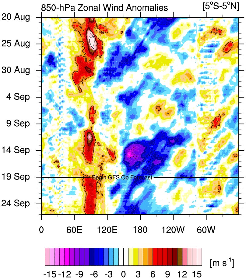
A nice burst is currently progged over teh next 10 days in teh equatorial pac to help cool off the waters a bit

_________________
Mugs
AKA:King: Snow Weenie
Self Proclaimed
WINTER 2014-15 : 55.12" +.02 for 6 coatings (avg. 35")
WINTER 2015-16 Total - 29.8" (Avg 35")
WINTER 2016-17 : 39.5" so far

amugs- Advanced Forecaster - Mod

- Posts : 15157
Reputation : 213
Join date : 2013-01-07
Age : 54
Location : Hillsdale,NJ
 Re: Long Range Thread 12.0
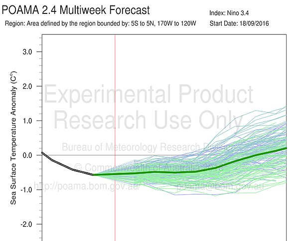
Very weak Nina here

_________________
Mugs
AKA:King: Snow Weenie
Self Proclaimed
WINTER 2014-15 : 55.12" +.02 for 6 coatings (avg. 35")
WINTER 2015-16 Total - 29.8" (Avg 35")
WINTER 2016-17 : 39.5" so far

amugs- Advanced Forecaster - Mod

- Posts : 15157
Reputation : 213
Join date : 2013-01-07
Age : 54
Location : Hillsdale,NJ
 Re: Long Range Thread 12.0
even with the easterly wind bursts all nino regions continue to warm. wonder if the warm waters surrounding nino areas are having a warming effect overall? anyway hearing nina forcing in the trop pac now even though we do not have an official nina yet.amugs wrote:A nice burst is currently progged over teh next 10 days in teh equatorial pac to help cool off the waters a bit


looks like its going to be a very tough call for this upcoming winter.

algae888- Advanced Forecaster

- Posts : 5311
Reputation : 46
Join date : 2013-02-05
Age : 62
Location : mt. vernon, new york
 Re: Long Range Thread 12.0
algae888 wrote:even with the easterly wind bursts all nino regions continue to warm. wonder if the warm waters surrounding nino areas are having a warming effect overall? anyway hearing nina forcing in the trop pac now even though we do not have an official nina yet.amugs wrote:A nice burst is currently progged over teh next 10 days in teh equatorial pac to help cool off the waters a bit
looks like its going to be a very tough call for this upcoming winter.
I'm not sure there is going to be much of a difference Al, IMHO of course, with respect to the overall big picture regarding trop pac forcing for the winter regardless of the textbook definition of where we fall ie: a weak La Niña or a neutral state on the Niña side of neutral. Like you said there have already been Niña like forcing present. The way things are setting up to me are such that other primary drivers that may play a bigger role in the big picture this year such as MJO/IO, Northern Pacific SSTA, stratosphere to name a few.
_________________
"In weather and in life, there's no winning and losing; there's only winning and learning."
WINTER 2012/2013 TOTALS 43.65"WINTER 2017/2018 TOTALS 62.85" WINTER 2022/2023 TOTALS 4.9"
WINTER 2013/2014 TOTALS 64.85"WINTER 2018/2019 TOTALS 14.25" WINTER 2023/2024 TOTALS 13.1"
WINTER 2014/2015 TOTALS 71.20"WINTER 2019/2020 TOTALS 6.35" WINTER 2024/2025 TOTALS 0.00
WINTER 2015/2016 TOTALS 35.00"WINTER 2020/2021 TOTALS 37.75"
WINTER 2016/2017 TOTALS 42.25"WINTER 2021/2022 TOTALS 31.65"

sroc4- Admin

- Posts : 8458
Reputation : 302
Join date : 2013-01-07
Location : Wading River, LI
 Re: Long Range Thread 12.0
With ssts this warm in the Atlantic, it certainly argues for the possibility of explosive development of any coastal low this upcoming season regardless if its rain or snow.
looks like its going to be a very tough call for this upcoming winter.

nutleyblizzard- Senior Enthusiast

- Posts : 1964
Reputation : 41
Join date : 2014-01-30
Age : 58
Location : Nutley, new jersey
 Re: Long Range Thread 12.0
For one indices and temp profile maps do not flip on a dime - it can take up to 7-10 days for this type of event I posted above to show up on SST maps. I am not rooting anything on but talking to pro mets about this is what I have learned.
The drivers - SAI, Strat (QBO), Solar activity, planetary configuration - don't laugh pro met Jim Witt has proven this time and time again, we have gone away from this due to our high tech equipment - SST's of IO/Pac - Atlantic is more for storms (changeover conditions etc)and possible WAR, and of course Joe Bastardi's juju!!
I am inclined to think we may see a weak Nina state if these burst continue which historically happens each change of seasons in the Southern Hemispherical region of the SOI
What interests me is this hangover effect after the Godzilla Nino - how is it play out - what drives the fluid pattern - oceans or the air that passesover them. Mets tell me in 101 they study this and tehre are still differing opins on this in our meteorological world.
Digest this info analogs here for a met
Positive PDO and weak Nina has a few examples...but not many. The examples we do have though are pretty good winters.
1983-1984
1984-1985
1995-1996
2000-2001
I'll signup for ANY one of these!!
_________________
Mugs
AKA:King: Snow Weenie
Self Proclaimed
WINTER 2014-15 : 55.12" +.02 for 6 coatings (avg. 35")
WINTER 2015-16 Total - 29.8" (Avg 35")
WINTER 2016-17 : 39.5" so far

amugs- Advanced Forecaster - Mod

- Posts : 15157
Reputation : 213
Join date : 2013-01-07
Age : 54
Location : Hillsdale,NJ
Page 5 of 40 •  1, 2, 3, 4, 5, 6 ... 22 ... 40
Page 5 of 40
Permissions in this forum:
You cannot reply to topics in this forum
 Home
Home