Long Range Thread 12.0
+30
StatenWx
Dunnzoo
weatherwatchermom
Quietace
dkodgis
mwilli5783
jrollins628
devsman
skinsfan1177
billg315
jmanley32
Snow88
chief7
Dtone
Isotherm
sroc4
docstox12
CPcantmeasuresnow
frank 638
track17
NjWeatherGuy
HectorO
SNOW MAN
rb924119
Math23x7
algae888
snow247
amugs
nutleyblizzard
Frank_Wx
34 posters
Page 6 of 40
Page 6 of 40 •  1 ... 5, 6, 7 ... 23 ... 40
 Re: Long Range Thread 12.0
With ssts this warm in the Atlantic, it certainly argues for the possibility of explosive development of any coastal low this upcoming season regardless if its rain or snow.
looks like its going to be a very tough call for this upcoming winter.
nutleyblizzard- Senior Enthusiast

- Posts : 1964
Join date : 2014-01-30
 Re: Long Range Thread 12.0
For one indices and temp profile maps do not flip on a dime - it can take up to 7-10 days for this type of event I posted above to show up on SST maps. I am not rooting anything on but talking to pro mets about this is what I have learned.
The drivers - SAI, Strat (QBO), Solar activity, planetary configuration - don't laugh pro met Jim Witt has proven this time and time again, we have gone away from this due to our high tech equipment - SST's of IO/Pac - Atlantic is more for storms (changeover conditions etc)and possible WAR, and of course Joe Bastardi's juju!!
I am inclined to think we may see a weak Nina state if these burst continue which historically happens each change of seasons in the Southern Hemispherical region of the SOI
What interests me is this hangover effect after the Godzilla Nino - how is it play out - what drives the fluid pattern - oceans or the air that passesover them. Mets tell me in 101 they study this and tehre are still differing opins on this in our meteorological world.
Digest this info analogs here for a met
Positive PDO and weak Nina has a few examples...but not many. The examples we do have though are pretty good winters.
1983-1984
1984-1985
1995-1996
2000-2001
I'll signup for ANY one of these!!
amugs- Advanced Forecaster - Mod

- Posts : 15156
Join date : 2013-01-07
 Re: Long Range Thread 12.0
Scott most of those factors, mjo, nao, and strat, are not very well modeled more than a week out. Going to make for a challenging Winter forecast unlike last year.

algae888- Advanced Forecaster

- Posts : 5311
Reputation : 46
Join date : 2013-02-05
Age : 62
Location : mt. vernon, new york
 Re: Long Range Thread 12.0
amugs wrote:For one indices and temp profile maps do not flip on a dime - it can take up to 7-10 days for this type of event I posted above to show up on SST maps. I am not rooting anything on but talking to pro mets about this is what I have learned.
The drivers - SAI, Strat (QBO), Solar activity, planetary configuration - don't laugh pro met Jim Witt has proven this time and time again, we have gone away from this due to our high tech equipment - SST's of IO/Pac - Atlantic is more for storms (changeover conditions etc)and possible WAR, and of course Joe Bastardi's juju!!
I am inclined to think we may see a weak Nina state if these burst continue which historically happens each change of seasons in the Southern Hemispherical region of the SOI
What interests me is this hangover effect after the Godzilla Nino - how is it play out - what drives the fluid pattern - oceans or the air that passesover them. Mets tell me in 101 they study this and tehre are still differing opins on this in our meteorological world.
Digest this info analogs here for a met
Positive PDO and weak Nina has a few examples...but not many. The examples we do have though are pretty good winters.
1983-1984
1984-1985
1995-1996
2000-2001
I'll signup for ANY one of these!!
Mugsy I would prefer to refer to those "Drivers" you mentioned above as the "parents" of the drivers for a given season. Yes they run the long term pattern(decades), but they simply guide the children the best they can; then simply hand over the keys for a night out on the town(winter season) so they can then fight over who drives, who sits shot gun and who takes the backseat into and through winter. For me the main "Driver" throughout a given season is really the global SST as a whole as the northern hemisphere heading into fall and then winter months as this is when we begin to re-establish the greatest temperature gradients between the equator and the N pole. Where are the SST in the Trop Pac relative to the N Pac. Where are the SST in the western Pac relative to the Eastern Pac; where the Trop Atlantic SST relative to the North Atlantic? Where are the Atlantic SST relative to the Pac SST temps? All of these collective differences influence the overall pattern. Ultimately and simply stated its these temperature differences, big or small relative to a given location(north to south; east to west, and/or surface to upper levels in the atmosphere), and the Coriolis effect, that move the air leading to the differences in the speed and position of the jet streams, and the differences in pressures across the N Hemisphere.
"Scott most of those factors, mjo, nao, and strat, are not very well modeled more than a week out. Going to make for a challenging Winter forecast unlike last year."
Al I totally agree. But that's not to say that any one or combination of any or all do not take over the driver seat to the pattern either short term or longer term. Ie: lets say the MJO pulses strongly in phases 7, 8, 1 for 2-3weeks in late Jan. There is a good chance that will heavily influence and drive the pattern down stream over NA for a significant period, assuming we are in a neutral ENSO state, and the Strat is relatively quiet.
I think its very difficult until hind sight can be realized to see the true drivers for a particular season. For instance, IMHO the super NINO we saw last winter was not the main or only driver. Remember many very prom mets stated over and over throughout last winter that despite how the winter ended up in anyone's given back yard, as a whole last season did not behave like a typical strong El Nino for many geographical locations. This was likely due to the fact that globally the equatorial SST, not just the trop Pac, were anomalously very strong/warm setting up an exceptionally strong equator-pole ward temp gradient which in turn led to one of the coldest and tightest stratospheric vortex's in recorded history. This in turned led to a mostly neutral to positive AO(despite very strong wave fluxes over the northern latitudes and strat warming attempts to weaken the strat vortex in Jan and Feb), with the exception of Jan which is when we saw the blizzard, which in turn kept the Polar and Arctic jets to the north for most of the winter, and the strong sub tropical jet dominated for our area.
With likely a neutral ENSO and the IO tempered relative to last year(although that's still evolving), I think the possibility of SSWE's (more likely if we get good Siberian snow growth by Nov), or MJO pulses, could dominate the drivers seat and shot gun in the proverbial car for periods this winter, and the ENSO status may take more of a back seat this winter. Obv this is all still evolving so we will cont to hurry up and wait on this evolution.
_________________
"In weather and in life, there's no winning and losing; there's only winning and learning."
WINTER 2012/2013 TOTALS 43.65"WINTER 2017/2018 TOTALS 62.85" WINTER 2022/2023 TOTALS 4.9"
WINTER 2013/2014 TOTALS 64.85"WINTER 2018/2019 TOTALS 14.25" WINTER 2023/2024 TOTALS 13.1"
WINTER 2014/2015 TOTALS 71.20"WINTER 2019/2020 TOTALS 6.35" WINTER 2024/2025 TOTALS 0.00
WINTER 2015/2016 TOTALS 35.00"WINTER 2020/2021 TOTALS 37.75"
WINTER 2016/2017 TOTALS 42.25"WINTER 2021/2022 TOTALS 31.65"

sroc4- Admin

- Posts : 8458
Reputation : 302
Join date : 2013-01-07
Location : Wading River, LI
 Re: Long Range Thread 12.0
scott good stuff and I agree with your assessment. will be fun to watch the evolution of all the indices as we get closer to winter. Siberian snow growth and comments by steve d and others feel the same...

"One of the facts I look at for potential snow growth is the state of the sea ice in the Arctic. When sea ice values are averaging below normal, as they are this year, the increased open waters leads to an increase in low level humidity around Siberia and a stronger thermal gradient overall. This factor would suggest a high potential for above normal snow growth which would help to disrupt the Polar Vortex and thus lead to a higher potential for a negative NAO/AO pattern.
The next several weeks will be very telling in this potential."
remember it's October snow growth that we want according to the experts. so we are in a good spot right now.

algae888- Advanced Forecaster

- Posts : 5311
Reputation : 46
Join date : 2013-02-05
Age : 62
Location : mt. vernon, new york
 Re: Long Range Thread 12.0
Scott,
totally agree and the ENSo state should not be a main driver this year as it was last year.
Snow growth that pro mets call the October season runs through this 1st week of Nov fro the set up and teh SAI (Snow Advance Index0 is the indicy that is mostly used by mets know due to its ability to forecast cold polar air of the NA continent other factors evolve but mostly lead to a N AO in the means for D-M time frame.
Great discussion guys and when I have more time I will write more but teh forecast fro teh next 10 days in a big, strong, whatever adjective you'd like to use of build up of snow in teh areas 60N and up towards the pole.
Rocky needs some water so I must go!
NOW

NOV 4th better look like this


totally agree and the ENSo state should not be a main driver this year as it was last year.
Snow growth that pro mets call the October season runs through this 1st week of Nov fro the set up and teh SAI (Snow Advance Index0 is the indicy that is mostly used by mets know due to its ability to forecast cold polar air of the NA continent other factors evolve but mostly lead to a N AO in the means for D-M time frame.
Great discussion guys and when I have more time I will write more but teh forecast fro teh next 10 days in a big, strong, whatever adjective you'd like to use of build up of snow in teh areas 60N and up towards the pole.
Rocky needs some water so I must go!
NOW

NOV 4th better look like this


_________________
Mugs
AKA:King: Snow Weenie
Self Proclaimed
WINTER 2014-15 : 55.12" +.02 for 6 coatings (avg. 35")
WINTER 2015-16 Total - 29.8" (Avg 35")
WINTER 2016-17 : 39.5" so far

amugs- Advanced Forecaster - Mod

- Posts : 15156
Reputation : 213
Join date : 2013-01-07
Age : 54
Location : Hillsdale,NJ
 Re: Long Range Thread 12.0
LOL Mugs...the snow and Ice chart is from Tuesday March 29th 2016. Not sure what the significance is.. lol
_________________
"In weather and in life, there's no winning and losing; there's only winning and learning."
WINTER 2012/2013 TOTALS 43.65"WINTER 2017/2018 TOTALS 62.85" WINTER 2022/2023 TOTALS 4.9"
WINTER 2013/2014 TOTALS 64.85"WINTER 2018/2019 TOTALS 14.25" WINTER 2023/2024 TOTALS 13.1"
WINTER 2014/2015 TOTALS 71.20"WINTER 2019/2020 TOTALS 6.35" WINTER 2024/2025 TOTALS 0.00
WINTER 2015/2016 TOTALS 35.00"WINTER 2020/2021 TOTALS 37.75"
WINTER 2016/2017 TOTALS 42.25"WINTER 2021/2022 TOTALS 31.65"

sroc4- Admin

- Posts : 8458
Reputation : 302
Join date : 2013-01-07
Location : Wading River, LI
 Re: Long Range Thread 12.0
We need this
N EPAC with High Latitude Blocking bookends baby

We get this and its over and out for us weenies +EPO and +NAO/AO

N EPAC with High Latitude Blocking bookends baby

We get this and its over and out for us weenies +EPO and +NAO/AO

_________________
Mugs
AKA:King: Snow Weenie
Self Proclaimed
WINTER 2014-15 : 55.12" +.02 for 6 coatings (avg. 35")
WINTER 2015-16 Total - 29.8" (Avg 35")
WINTER 2016-17 : 39.5" so far

amugs- Advanced Forecaster - Mod

- Posts : 15156
Reputation : 213
Join date : 2013-01-07
Age : 54
Location : Hillsdale,NJ
 Re: Long Range Thread 12.0
Lets see what this looks like two weeks from now:


_________________
"In weather and in life, there's no winning and losing; there's only winning and learning."
WINTER 2012/2013 TOTALS 43.65"WINTER 2017/2018 TOTALS 62.85" WINTER 2022/2023 TOTALS 4.9"
WINTER 2013/2014 TOTALS 64.85"WINTER 2018/2019 TOTALS 14.25" WINTER 2023/2024 TOTALS 13.1"
WINTER 2014/2015 TOTALS 71.20"WINTER 2019/2020 TOTALS 6.35" WINTER 2024/2025 TOTALS 0.00
WINTER 2015/2016 TOTALS 35.00"WINTER 2020/2021 TOTALS 37.75"
WINTER 2016/2017 TOTALS 42.25"WINTER 2021/2022 TOTALS 31.65"

sroc4- Admin

- Posts : 8458
Reputation : 302
Join date : 2013-01-07
Location : Wading River, LI
 Re: Long Range Thread 12.0
sroc4 wrote:LOL Mugs...the snow and Ice chart is from Tuesday March 29th 2016. Not sure what the significance is.. lol
I could not find one from Nov 4th 2015 - all teh site just go back archived to Jan 1 so i looked up a parallel to teh date for snow and ice and it was this week in late March - how true off the site but this is WHAT I WANT TO SEE ON NOV 4TH in the High Latitude Regions is me point !!!!
Crap I have a pile papers to grade
Ciao Ciao
_________________
Mugs
AKA:King: Snow Weenie
Self Proclaimed
WINTER 2014-15 : 55.12" +.02 for 6 coatings (avg. 35")
WINTER 2015-16 Total - 29.8" (Avg 35")
WINTER 2016-17 : 39.5" so far

amugs- Advanced Forecaster - Mod

- Posts : 15156
Reputation : 213
Join date : 2013-01-07
Age : 54
Location : Hillsdale,NJ
 Re: Long Range Thread 12.0
sroc4 wrote:Lets see what this looks like two weeks from now:
That and Rocky my pet - if he may be teh prognosticator of the SAI - HAHAHAHA!!
Lock in step baby!!
Updates to come.
_________________
Mugs
AKA:King: Snow Weenie
Self Proclaimed
WINTER 2014-15 : 55.12" +.02 for 6 coatings (avg. 35")
WINTER 2015-16 Total - 29.8" (Avg 35")
WINTER 2016-17 : 39.5" so far

amugs- Advanced Forecaster - Mod

- Posts : 15156
Reputation : 213
Join date : 2013-01-07
Age : 54
Location : Hillsdale,NJ
 Re: Long Range Thread 12.0
amugs wrote:sroc4 wrote:LOL Mugs...the snow and Ice chart is from Tuesday March 29th 2016. Not sure what the significance is.. lol
I could not find one from Nov 4th 2015 - all teh site just go back archived to Jan 1 so i looked up a parallel to teh date for snow and ice and it was this week in late March - how true off the site but this is WHAT I WANT TO SEE ON NOV 4TH in the High Latitude Regions is me point !!!!
Crap I have a pile papers to grade

Ciao Ciao
Git er done buddy. Then you can go out and play.

_________________
"In weather and in life, there's no winning and losing; there's only winning and learning."
WINTER 2012/2013 TOTALS 43.65"WINTER 2017/2018 TOTALS 62.85" WINTER 2022/2023 TOTALS 4.9"
WINTER 2013/2014 TOTALS 64.85"WINTER 2018/2019 TOTALS 14.25" WINTER 2023/2024 TOTALS 13.1"
WINTER 2014/2015 TOTALS 71.20"WINTER 2019/2020 TOTALS 6.35" WINTER 2024/2025 TOTALS 0.00
WINTER 2015/2016 TOTALS 35.00"WINTER 2020/2021 TOTALS 37.75"
WINTER 2016/2017 TOTALS 42.25"WINTER 2021/2022 TOTALS 31.65"

sroc4- Admin

- Posts : 8458
Reputation : 302
Join date : 2013-01-07
Location : Wading River, LI
 Re: Long Range Thread 12.0
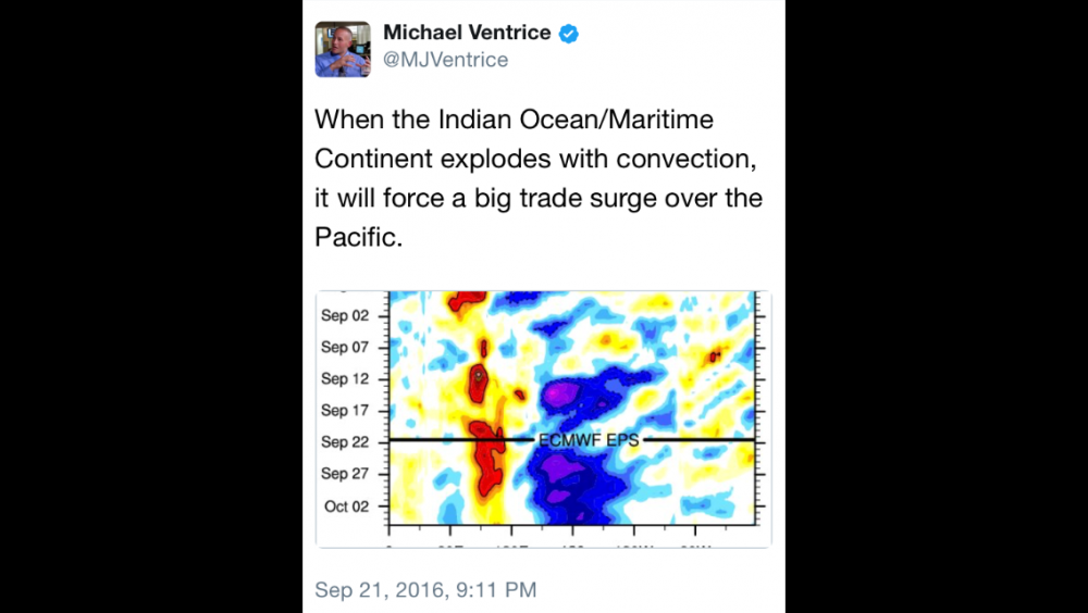
UGGH - I am addicted: Ventrice tweeted this
_________________
Mugs
AKA:King: Snow Weenie
Self Proclaimed
WINTER 2014-15 : 55.12" +.02 for 6 coatings (avg. 35")
WINTER 2015-16 Total - 29.8" (Avg 35")
WINTER 2016-17 : 39.5" so far

amugs- Advanced Forecaster - Mod

- Posts : 15156
Reputation : 213
Join date : 2013-01-07
Age : 54
Location : Hillsdale,NJ
 Re: Long Range Thread 12.0

Looking farther ahead to the end of fall and the beginning of winter, we expect that there will be a significant change in the pattern which would result in a winter that is rather different from the mild winter that we saw last year across much of the country. In fact, the pattern is expected to more closely resemble the winters of 2013-2014 and 2014-2015. A trough position roughly near Hudson Bay is expected to bring frequent and persistent outbreaks of arctic air to much of the central and eastern US. In this scenario much of the west would see milder conditions dominate the winter pattern.
One of the keys to our final winter forecast (which will be released on November 21, 2016) will be determining when the pattern change from the relatively warm fall to the colder winter pattern will occur. If the pattern change occurs in December, a much larger region of the central and eastern U.S. will see below normal temperatures for the winter as a whole and we would have to remove the Gulf Coast from the "above normal" category.
However, there are signs that we will see a "false start" to winter with an initial cold snap in November followed by a rather mild December. Regardless, we expect that the second half of winter will feature an extended period of classic winter weather for much of the central and eastern parts of the country
_________________
Mugs
AKA:King: Snow Weenie
Self Proclaimed
WINTER 2014-15 : 55.12" +.02 for 6 coatings (avg. 35")
WINTER 2015-16 Total - 29.8" (Avg 35")
WINTER 2016-17 : 39.5" so far

amugs- Advanced Forecaster - Mod

- Posts : 15156
Reputation : 213
Join date : 2013-01-07
Age : 54
Location : Hillsdale,NJ
 Re: Long Range Thread 12.0
amugs wrote:
Looking farther ahead to the end of fall and the beginning of winter, we expect that there will be a significant change in the pattern which would result in a winter that is rather different from the mild winter that we saw last year across much of the country. In fact, the pattern is expected to more closely resemble the winters of 2013-2014 and 2014-2015. A trough position roughly near Hudson Bay is expected to bring frequent and persistent outbreaks of arctic air to much of the central and eastern US. In this scenario much of the west would see milder conditions dominate the winter pattern.
One of the keys to our final winter forecast (which will be released on November 21, 2016) will be determining when the pattern change from the relatively warm fall to the colder winter pattern will occur. If the pattern change occurs in December, a much larger region of the central and eastern U.S. will see below normal temperatures for the winter as a whole and we would have to remove the Gulf Coast from the "above normal" category.
However, there are signs that we will see a "false start" to winter with an initial cold snap in November followed by a rather mild December. Regardless, we expect that the second half of winter will feature an extended period of classic winter weather for much of the central and eastern parts of the country
Mugs, when I read this I let out a LOUD WOOOOHOOOO !!! Hopefully it all comes together. Ok back to hibernation.

SNOW MAN- Senior Enthusiast

- Posts : 1361
Reputation : 25
Join date : 2013-01-13
Age : 65
Location : Marshalls Creek Pa.
 Re: Long Range Thread 12.0
all nino regions have significantly warmed in the last 10 days. all are now neutral warm...
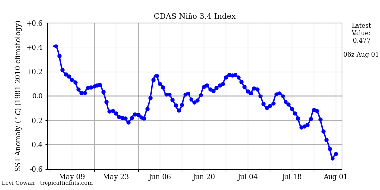

it's almost certain winter will not start (dec. 1st) with a nina. what differences will a warm neutral or a cold neutral create if any? warm neutral now must be considered with this latest spike and sub surface continuing to warm.


it's almost certain winter will not start (dec. 1st) with a nina. what differences will a warm neutral or a cold neutral create if any? warm neutral now must be considered with this latest spike and sub surface continuing to warm.

algae888- Advanced Forecaster

- Posts : 5311
Reputation : 46
Join date : 2013-02-05
Age : 62
Location : mt. vernon, new york
 Re: Long Range Thread 12.0
steve d on the qbo...
"Anyway, the QBO this year is clearly going to be of a positive state. The question is just how strong will the QBO be? Given the data we have, the QBO is on the waning months of being positive. The support for a positive state is gone at 1 to 5 MB and rapidly weakening at 10 MB and 20 MB. Changes are coming, but a switch to a negative state in the QBO is not likely until next Spring or early Summer. With that, we know the QBO will be positive but weakening.
A positive (westerly) but weakening QBO leads to greater support for high latitude and also increases support for a negative NAO pattern for the Atlantic. The positive QBO also lends support to more major stratospheric warming events as well. A positive QBO if too strong though ( over 10 m/s) can lead to a Polar jet stream that is too strong and push the negative NAO block further east towards Iceland and northwestern Europe.
Currently, the QBO state is wavering between 6 m/s and 11 m/s. The QBO peaked at 30 MB at around 13.38 m/s back last October and trends suggest that the QBO should stay well below those levels given the observations seen further up in the stratosphere. A QBO between 6 to 10 m/s would support a sustained negative NAO pattern and typically leads to cold weather patterns for the Eastern United States.
"
I do not know much on the qbo and have been hearing conflicting info on it. does anyone know where we want it to be and how significant of an impact does it have on our sensible weather?

algae888- Advanced Forecaster

- Posts : 5311
Reputation : 46
Join date : 2013-02-05
Age : 62
Location : mt. vernon, new york
 Re: Long Range Thread 12.0
CFSv2 Temp
Fits the idea of what we have been discussing
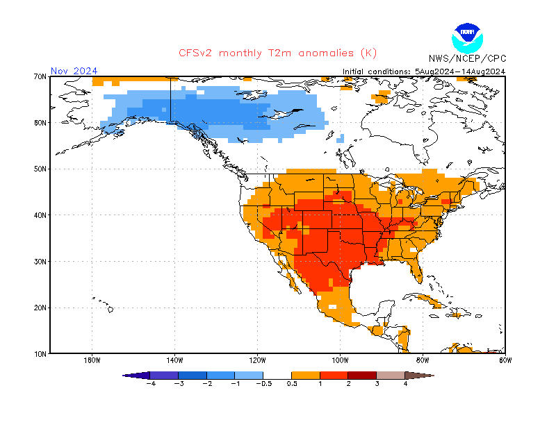
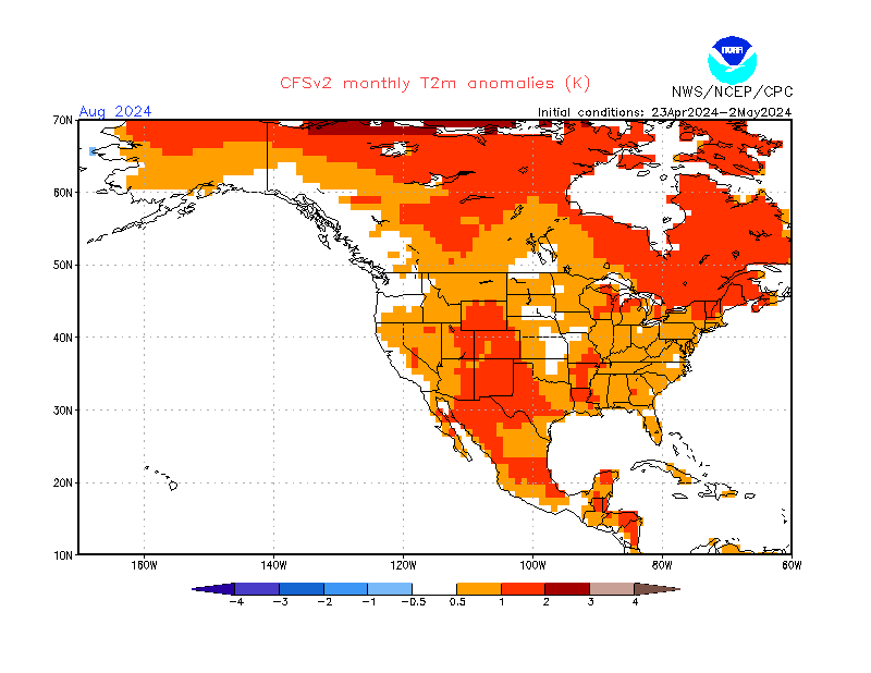
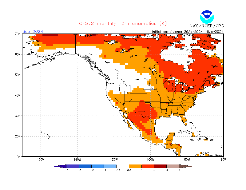
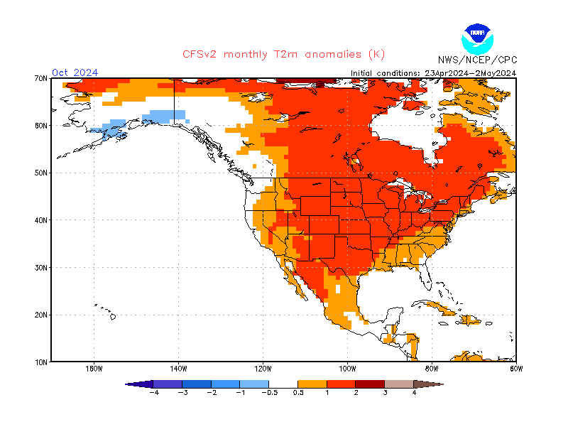
Fits the idea of what we have been discussing


_________________
Mugs
AKA:King: Snow Weenie
Self Proclaimed
WINTER 2014-15 : 55.12" +.02 for 6 coatings (avg. 35")
WINTER 2015-16 Total - 29.8" (Avg 35")
WINTER 2016-17 : 39.5" so far

amugs- Advanced Forecaster - Mod

- Posts : 15156
Reputation : 213
Join date : 2013-01-07
Age : 54
Location : Hillsdale,NJ
 Re: Long Range Thread 12.0
algae888 wrote:steve d on the qbo...
"Anyway, the QBO this year is clearly going to be of a positive state. The question is just how strong will the QBO be? Given the data we have, the QBO is on the waning months of being positive. The support for a positive state is gone at 1 to 5 MB and rapidly weakening at 10 MB and 20 MB. Changes are coming, but a switch to a negative state in the QBO is not likely until next Spring or early Summer. With that, we know the QBO will be positive but weakening.
A positive (westerly) but weakening QBO leads to greater support for high latitude and also increases support for a negative NAO pattern for the Atlantic. The positive QBO also lends support to more major stratospheric warming events as well. A positive QBO if too strong though ( over 10 m/s) can lead to a Polar jet stream that is too strong and push the negative NAO block further east towards Iceland and northwestern Europe.
Currently, the QBO state is wavering between 6 m/s and 11 m/s. The QBO peaked at 30 MB at around 13.38 m/s back last October and trends suggest that the QBO should stay well below those levels given the observations seen further up in the stratosphere. A QBO between 6 to 10 m/s would support a sustained negative NAO pattern and typically leads to cold weather patterns for the Eastern United States.
"
I do not know much on the qbo and have been hearing conflicting info on it. does anyone know where we want it to be and how significant of an impact does it have on our sensible weather?
Al I have been researching this a lot lately and I am finding some interesting information; some of which contradicts some of the info Steve is saying to a certain extent. I am going to continue to research and might try to write it up in here once I digest it all.
_________________
"In weather and in life, there's no winning and losing; there's only winning and learning."
WINTER 2012/2013 TOTALS 43.65"WINTER 2017/2018 TOTALS 62.85" WINTER 2022/2023 TOTALS 4.9"
WINTER 2013/2014 TOTALS 64.85"WINTER 2018/2019 TOTALS 14.25" WINTER 2023/2024 TOTALS 13.1"
WINTER 2014/2015 TOTALS 71.20"WINTER 2019/2020 TOTALS 6.35" WINTER 2024/2025 TOTALS 0.00
WINTER 2015/2016 TOTALS 35.00"WINTER 2020/2021 TOTALS 37.75"
WINTER 2016/2017 TOTALS 42.25"WINTER 2021/2022 TOTALS 31.65"

sroc4- Admin

- Posts : 8458
Reputation : 302
Join date : 2013-01-07
Location : Wading River, LI
 Re: Long Range Thread 12.0
Ok scott can't wait to read it. Also there are major changes in all enso regions. A very warm spike.We are almost at a weak nino. I guess that would put a monkey wrench into the winter forecast.

algae888- Advanced Forecaster

- Posts : 5311
Reputation : 46
Join date : 2013-02-05
Age : 62
Location : mt. vernon, new york
 Re: Long Range Thread 12.0
Also warming off the northwest us coast. +pdo and weak nino?

algae888- Advanced Forecaster

- Posts : 5311
Reputation : 46
Join date : 2013-02-05
Age : 62
Location : mt. vernon, new york
 Re: Long Range Thread 12.0
I'm not sure what data he is examining, but empirically, the evidence is insufficient for the assertions posited regarding the QBO, and I would vehemently disagree with them.
Another problem I often see is the 1:1 correlation some attempt to make between the QBO and surface temperatures; it doesn't work like that. The QBO modulates stratospheric wind behavior which modulates stratospheric polar vortex intensity, which consequently correlates to the ability of vertically propagating Rossby waves to induce vortex perturbation and significant warming. Following it further -- depending upon preset conditions, it would then increase or decrease the probability of downward propagation, and tropospheric reflection whereby the northern annular mode responds, and then, finally, the subsequent effect on surface temperatures. So to assert that the QBO implies X with respect to surface temperatures is a flawed concept. It's a multifactorial pathway and sometimes it does work well while other times it doesn't (e.g., 2010-11, strong +QBO, strong tropospheric blocking).
Another problem I often see is the 1:1 correlation some attempt to make between the QBO and surface temperatures; it doesn't work like that. The QBO modulates stratospheric wind behavior which modulates stratospheric polar vortex intensity, which consequently correlates to the ability of vertically propagating Rossby waves to induce vortex perturbation and significant warming. Following it further -- depending upon preset conditions, it would then increase or decrease the probability of downward propagation, and tropospheric reflection whereby the northern annular mode responds, and then, finally, the subsequent effect on surface temperatures. So to assert that the QBO implies X with respect to surface temperatures is a flawed concept. It's a multifactorial pathway and sometimes it does work well while other times it doesn't (e.g., 2010-11, strong +QBO, strong tropospheric blocking).
 Re: Long Range Thread 12.0
And for those of you wanting to know what is happening with the artcic sea ice well it has bounced back considerably which is a good sign for our cold air pool.source as we head towards winter but still way below normal. This area is progged to have LP after LP storms of snow and cold on it's backside so this will increase in teh next few days some more.


_________________
Mugs
AKA:King: Snow Weenie
Self Proclaimed
WINTER 2014-15 : 55.12" +.02 for 6 coatings (avg. 35")
WINTER 2015-16 Total - 29.8" (Avg 35")
WINTER 2016-17 : 39.5" so far

amugs- Advanced Forecaster - Mod

- Posts : 15156
Reputation : 213
Join date : 2013-01-07
Age : 54
Location : Hillsdale,NJ
 Re: Long Range Thread 12.0
Look at how much heat is still there in the PAC - Nino Hanover peeps
Look at the blob in the Gulf of Alaska region - nice lets keep that till March if we can!!!

Look at the blob in the Gulf of Alaska region - nice lets keep that till March if we can!!!

_________________
Mugs
AKA:King: Snow Weenie
Self Proclaimed
WINTER 2014-15 : 55.12" +.02 for 6 coatings (avg. 35")
WINTER 2015-16 Total - 29.8" (Avg 35")
WINTER 2016-17 : 39.5" so far

amugs- Advanced Forecaster - Mod

- Posts : 15156
Reputation : 213
Join date : 2013-01-07
Age : 54
Location : Hillsdale,NJ
 Re: Long Range Thread 12.0
ACCUWEATHER SAYING NICE FOR US PEEPS THIS WINTER!!
http://www.accuweather.com/en/weather-news/2016-2017-us-winter-forecast-northeast-above-normal-snow-freeze-hurt-citrus-south/60277878
http://www.accuweather.com/en/weather-news/2016-2017-us-winter-forecast-northeast-above-normal-snow-freeze-hurt-citrus-south/60277878
_________________
Mugs
AKA:King: Snow Weenie
Self Proclaimed
WINTER 2014-15 : 55.12" +.02 for 6 coatings (avg. 35")
WINTER 2015-16 Total - 29.8" (Avg 35")
WINTER 2016-17 : 39.5" so far

amugs- Advanced Forecaster - Mod

- Posts : 15156
Reputation : 213
Join date : 2013-01-07
Age : 54
Location : Hillsdale,NJ
 Re: Long Range Thread 12.0
Look at the Snow Growth in Siberia - WOW!!

1 week ago


1 week ago

_________________
Mugs
AKA:King: Snow Weenie
Self Proclaimed
WINTER 2014-15 : 55.12" +.02 for 6 coatings (avg. 35")
WINTER 2015-16 Total - 29.8" (Avg 35")
WINTER 2016-17 : 39.5" so far

amugs- Advanced Forecaster - Mod

- Posts : 15156
Reputation : 213
Join date : 2013-01-07
Age : 54
Location : Hillsdale,NJ
 Re: Long Range Thread 12.0
amugs wrote:Look at the Snow Growth in Siberia - WOW!!
1 week ago
Departure from normal:

_________________
"In weather and in life, there's no winning and losing; there's only winning and learning."
WINTER 2012/2013 TOTALS 43.65"WINTER 2017/2018 TOTALS 62.85" WINTER 2022/2023 TOTALS 4.9"
WINTER 2013/2014 TOTALS 64.85"WINTER 2018/2019 TOTALS 14.25" WINTER 2023/2024 TOTALS 13.1"
WINTER 2014/2015 TOTALS 71.20"WINTER 2019/2020 TOTALS 6.35" WINTER 2024/2025 TOTALS 0.00
WINTER 2015/2016 TOTALS 35.00"WINTER 2020/2021 TOTALS 37.75"
WINTER 2016/2017 TOTALS 42.25"WINTER 2021/2022 TOTALS 31.65"

sroc4- Admin

- Posts : 8458
Reputation : 302
Join date : 2013-01-07
Location : Wading River, LI
Page 6 of 40 •  1 ... 5, 6, 7 ... 23 ... 40
Page 6 of 40
Permissions in this forum:
You cannot reply to topics in this forum
 Home
Home