Long Range Thread 12.0
+30
StatenWx
Dunnzoo
weatherwatchermom
Quietace
dkodgis
mwilli5783
jrollins628
devsman
skinsfan1177
billg315
jmanley32
Snow88
chief7
Dtone
Isotherm
sroc4
docstox12
CPcantmeasuresnow
frank 638
track17
NjWeatherGuy
HectorO
SNOW MAN
rb924119
Math23x7
algae888
snow247
amugs
nutleyblizzard
Frank_Wx
34 posters
Page 22 of 40
Page 22 of 40 •  1 ... 12 ... 21, 22, 23 ... 31 ... 40
 Re: Long Range Thread 12.0
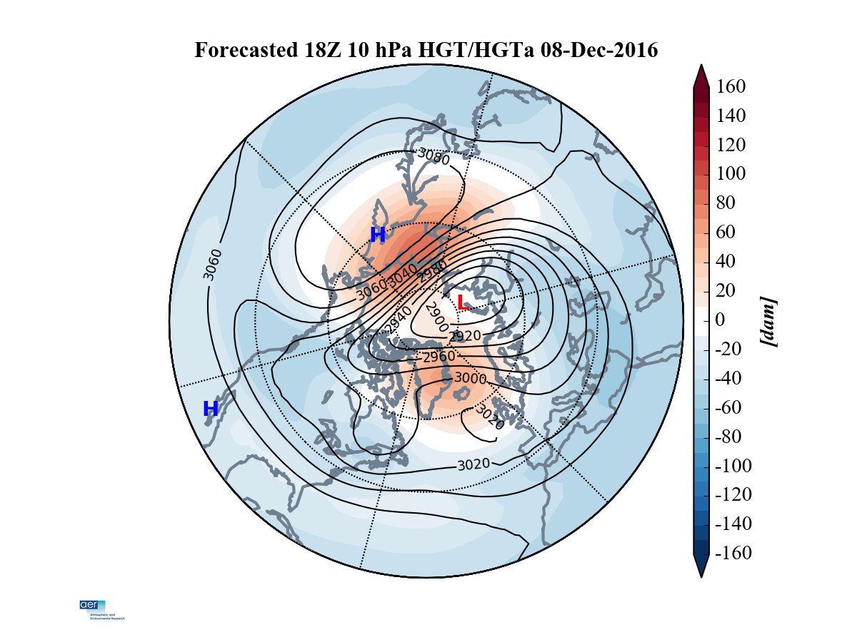
I would agree, Frank. The tropospheric precursor pattern was very much oriented to constructive interfere with climatological wave-1, and we see the resultant spike in wave-1 forecasted next week. Wave-2 amplitudes are down near record lows, much like last year. Wave-1 is generally less effective as you know.
I'm not sure that the strat PV will remain weaker than normal - I think it will probably be stronger than normal as winter continues with a decreasing probability of a SSW, until late February. So to miss the opportunity now is very bad in my opinion.
I'm not sure that the strat PV will remain weaker than normal - I think it will probably be stronger than normal as winter continues with a decreasing probability of a SSW, until late February. So to miss the opportunity now is very bad in my opinion.
 Re: Long Range Thread 12.0
White turkey day for N&W - said we'd have a white turkey day - somewhere ahahaha!!


amugs- Advanced Forecaster - Mod

- Posts : 15157
Join date : 2013-01-07
 Re: Long Range Thread 12.0
yea mugs we don't need arctic air in DJF. +1 or so with an active pattern will work. looks active for awhile. nino hangover?amugs wrote:White turkey day for N&W - said we'd have a white turkey day - somewhere ahahaha!!

algae888- Advanced Forecaster

- Posts : 5311
Reputation : 46
Join date : 2013-02-05
Age : 62
Location : mt. vernon, new york
 Re: Long Range Thread 12.0
Think it's going to be too warm for any white stuff on Thanksgiving unless you live further Northwest. Forecast is in the 50's

HectorO- Pro Enthusiast

- Posts : 977
Reputation : 27
Join date : 2013-01-11
 Re: Long Range Thread 12.0
HectorO wrote:Think it's going to be too warm for any white stuff on Thanksgiving unless you live further Northwest. Forecast is in the 50's
Basically North of Rt 80, Upper Northern NJ looks to be white but light and as you move further north - could cause some slippery conditions in the morning.

_________________
Mugs
AKA:King: Snow Weenie
Self Proclaimed
WINTER 2014-15 : 55.12" +.02 for 6 coatings (avg. 35")
WINTER 2015-16 Total - 29.8" (Avg 35")
WINTER 2016-17 : 39.5" so far

amugs- Advanced Forecaster - Mod

- Posts : 15157
Reputation : 213
Join date : 2013-01-07
Age : 54
Location : Hillsdale,NJ
 Re: Long Range Thread 12.0
Euro - major improvements in the PAC - ala 1993

The cold air and storms will come with this look

The cold air and storms will come with this look
_________________
Mugs
AKA:King: Snow Weenie
Self Proclaimed
WINTER 2014-15 : 55.12" +.02 for 6 coatings (avg. 35")
WINTER 2015-16 Total - 29.8" (Avg 35")
WINTER 2016-17 : 39.5" so far

amugs- Advanced Forecaster - Mod

- Posts : 15157
Reputation : 213
Join date : 2013-01-07
Age : 54
Location : Hillsdale,NJ
 Re: Long Range Thread 12.0
First legit snowstorm potential by this map here


_________________
Mugs
AKA:King: Snow Weenie
Self Proclaimed
WINTER 2014-15 : 55.12" +.02 for 6 coatings (avg. 35")
WINTER 2015-16 Total - 29.8" (Avg 35")
WINTER 2016-17 : 39.5" so far

amugs- Advanced Forecaster - Mod

- Posts : 15157
Reputation : 213
Join date : 2013-01-07
Age : 54
Location : Hillsdale,NJ
 Re: Long Range Thread 12.0
amugs wrote:First legit snowstorm potential by this map here
As impressive as that looks, if you take a broader look at the Northern Hemisphere, you will see that at hr 240, the polar vortex is over Siberia. Also, looking at the 850mb temperatures, they're marginal. I need to see a lot more of this on the models before I can get excited.
Math23x7- Wx Statistician Guru

- Posts : 2382
Reputation : 68
Join date : 2013-01-08
 Re: Long Range Thread 12.0
I'm hearing the euro weeklies look good for weeks 3 and 4. -epo, ao, and nao plus a positive PNA

algae888- Advanced Forecaster

- Posts : 5311
Reputation : 46
Join date : 2013-02-05
Age : 62
Location : mt. vernon, new york
 Re: Long Range Thread 12.0
Math23x7 wrote:amugs wrote:First legit snowstorm potential by this map here
As impressive as that looks, if you take a broader look at the Northern Hemisphere, you will see that at hr 240, the polar vortex is over Siberia. Also, looking at the 850mb temperatures, they're marginal. I need to see a lot more of this on the models before I can get excited.
Mike what do you want a this stage - we are coming off of a Super Nino with a massive hangover as I have explained on here. This look is fine for we are at this stage. You are looking for siberian cold/PV? May wait till middle to end of Dec for a cross polar flow. You are building the heights in the arctic and EPO region in LR so what goes up must come down. We have to work with what we have and the coast and ocean island may not be in the cards this winter. Marginal at this time of year is good for the N& W areas so as teh precip falls you cool teh column of air and they will cash in areas N of I 80 and some N of I84. Any chance of white gold and accumulating at that is fine by atthis stage - we have sucked goose eggs these past few winters in Dec so I will take this at this stage.

_________________
Mugs
AKA:King: Snow Weenie
Self Proclaimed
WINTER 2014-15 : 55.12" +.02 for 6 coatings (avg. 35")
WINTER 2015-16 Total - 29.8" (Avg 35")
WINTER 2016-17 : 39.5" so far

amugs- Advanced Forecaster - Mod

- Posts : 15157
Reputation : 213
Join date : 2013-01-07
Age : 54
Location : Hillsdale,NJ
 Re: Long Range Thread 12.0
I'm losing confidence in the storm threat around the 27th. It's still pretty far out so changes are possible, but the upper air pattern does not look conducive for a wintry event. Here's a look at the 12z ECM ENS

It's a progressive pattern. The western ridge flattens due to the oncoming trough in the PAC NW so the H5 energy either shears out or scatters across our area. It's possible we see snow showers from the upper energy but that should be the extent of it.
It appears the next possible event is around December 1st.

The upper air pattern seems slightly more favorable by then but we're talking long range here. The low heights are removed from Alaska and the western U.S. and higher heights are trying to build in. The -NAO amplifies further and there's a deepening trough over the center of the country. The strong block may save us from a full blown cutter and could call for a Miller B type event.

As mentioned, the NAO will go negative the end of this month and peak in early December. So December 1st looks like a better chance for snow instead of the 27th. Will update in a couple of days.

It's a progressive pattern. The western ridge flattens due to the oncoming trough in the PAC NW so the H5 energy either shears out or scatters across our area. It's possible we see snow showers from the upper energy but that should be the extent of it.
It appears the next possible event is around December 1st.

The upper air pattern seems slightly more favorable by then but we're talking long range here. The low heights are removed from Alaska and the western U.S. and higher heights are trying to build in. The -NAO amplifies further and there's a deepening trough over the center of the country. The strong block may save us from a full blown cutter and could call for a Miller B type event.

As mentioned, the NAO will go negative the end of this month and peak in early December. So December 1st looks like a better chance for snow instead of the 27th. Will update in a couple of days.
_________________
_______________________________________________________________________________________________________
CLICK HERE to view NJ Strong Snowstorm Classifications
 Re: Long Range Thread 12.0
Forcing by the end of this month favors an MJO in phases 5 or 6. I fear once we get past the -NAO regime the first few days of December, we'll turn to a much above normal weather pattern.


_________________
_______________________________________________________________________________________________________
CLICK HERE to view NJ Strong Snowstorm Classifications
 Re: Long Range Thread 12.0
Burst of easterly winds end of this month west of the Dateline means pattern may shift to LA Nina like sometime in early to mid December.


_________________
_______________________________________________________________________________________________________
CLICK HERE to view NJ Strong Snowstorm Classifications
 Re: Long Range Thread 12.0
Frank_Wx wrote:Forcing by the end of this month favors an MJO in phases 5 or 6. I fear once we get past the -NAO regime the first few days of December, we'll turn to a much above normal weather pattern.
Ehh, whatever, I'm over it already lol. Whatever happens happens. Decembers aren't what they used to be. So many things affecting climate. Time for snow lovers to start re-locating. Yellowknife Canada?

HectorO- Pro Enthusiast

- Posts : 977
Reputation : 27
Join date : 2013-01-11
 Re: Long Range Thread 12.0
HectorO wrote:Frank_Wx wrote:Forcing by the end of this month favors an MJO in phases 5 or 6. I fear once we get past the -NAO regime the first few days of December, we'll turn to a much above normal weather pattern.
Ehh, whatever, I'm over it already lol. Whatever happens happens. Decembers aren't what they used to be. So many things affecting climate. Time for snow lovers to start re-locating. Yellowknife Canada?
I'm not sure I feel comfortable moving to a place called yellowknife
_________________
_______________________________________________________________________________________________________
CLICK HERE to view NJ Strong Snowstorm Classifications
 Re: Long Range Thread 12.0
The day 8-10 H5 height anomalies are not awful. Low heights removed from the GOA with a substantial west based -NAO. One of these storms will not be able to cut at some point. Maybe it's the storm on the 1st or the one after that.


_________________
_______________________________________________________________________________________________________
CLICK HERE to view NJ Strong Snowstorm Classifications
 Re: Long Range Thread 12.0
This PNA is killing us


_________________
_______________________________________________________________________________________________________
CLICK HERE to view NJ Strong Snowstorm Classifications
 Re: Long Range Thread 12.0
^^
ftp://ftp.cdc.noaa.gov/Public/gbates/reforecast2/teleconn/4indices.png
Looks good
ftp://ftp.cdc.noaa.gov/Public/gbates/reforecast2/teleconn/4indices.png
Looks good

Snow88- Senior Enthusiast

- Posts : 2193
Reputation : 4
Join date : 2013-01-09
Age : 36
Location : Brooklyn, NY
 Re: Long Range Thread 12.0
12z GEFS valid 25th - 30th

12z GEFS valid 29th - 4th

Looks like we see patten retrogressiom week 4 of November into week 1 of December. The retrograding ridge in the NPAC favors a trough over the Midwest.

12z GEFS valid 29th - 4th

Looks like we see patten retrogressiom week 4 of November into week 1 of December. The retrograding ridge in the NPAC favors a trough over the Midwest.
_________________
_______________________________________________________________________________________________________
CLICK HERE to view NJ Strong Snowstorm Classifications
 Re: Long Range Thread 12.0
Mean zonal winds point to a strengthening Strat PV to climo levels in early December. If this comes to fruition it could take our AO positive


_________________
_______________________________________________________________________________________________________
CLICK HERE to view NJ Strong Snowstorm Classifications
 Re: Long Range Thread 12.0
This would be amazing IF it were to actually happen a Counter Clockwise flow up North - skeptical but who the heck knows


_________________
Mugs
AKA:King: Snow Weenie
Self Proclaimed
WINTER 2014-15 : 55.12" +.02 for 6 coatings (avg. 35")
WINTER 2015-16 Total - 29.8" (Avg 35")
WINTER 2016-17 : 39.5" so far

amugs- Advanced Forecaster - Mod

- Posts : 15157
Reputation : 213
Join date : 2013-01-07
Age : 54
Location : Hillsdale,NJ
 Re: Long Range Thread 12.0
Just spent the morning throwing up after looking at long range guidance.
The main Tropospheric PV looks to remain in Siberia for the foreseeable future keeping the U.S. devoid of major cold. The west will remain largely under a -PNA thanks to upper energy digging into the region from a ridge over the Aleutians and a strong PAC jet.
The main Tropospheric PV looks to remain in Siberia for the foreseeable future keeping the U.S. devoid of major cold. The west will remain largely under a -PNA thanks to upper energy digging into the region from a ridge over the Aleutians and a strong PAC jet.
_________________
_______________________________________________________________________________________________________
CLICK HERE to view NJ Strong Snowstorm Classifications
 Re: Long Range Thread 12.0
MJO in phase 2 - this is what the reanalysis looks like during cold ENSO events. UGLY.


_________________
_______________________________________________________________________________________________________
CLICK HERE to view NJ Strong Snowstorm Classifications
 Re: Long Range Thread 12.0
So in other words warm and no snow except way up north? Seems the lr has been highly uncertain one week excitement next week barfing lol. To all have a gr8 turkey day! At least it's not 70!

jmanley32- Senior Enthusiast

- Posts : 20647
Reputation : 108
Join date : 2013-12-12
Age : 43
Location : Yonkers, NY
 Re: Long Range Thread 12.0
Speaking about 70, since the cold is not coming, the warm will be. I expect we get back to last year's story...warmer in a week or two and back to cutting the grass.

dkodgis- Senior Enthusiast

- Posts : 2694
Reputation : 98
Join date : 2013-12-29
 Re: Long Range Thread 12.0
Here we ago again back to warm mild boring Dec what ever happened to our Dec to rember I thought this Dec was so post to be cold and stormy.
frank 638- Senior Enthusiast

- Posts : 2882
Reputation : 37
Join date : 2016-01-01
Age : 41
Location : bronx ny
 Re: Long Range Thread 12.0
Many people called for a cold and snowy December

Snow88- Senior Enthusiast

- Posts : 2193
Reputation : 4
Join date : 2013-01-09
Age : 36
Location : Brooklyn, NY
Page 22 of 40 •  1 ... 12 ... 21, 22, 23 ... 31 ... 40
Page 22 of 40
Permissions in this forum:
You cannot reply to topics in this forum
 Home
Home