Long Range Thread 12.0
+30
StatenWx
Dunnzoo
weatherwatchermom
Quietace
dkodgis
mwilli5783
jrollins628
devsman
skinsfan1177
billg315
jmanley32
Snow88
chief7
Dtone
Isotherm
sroc4
docstox12
CPcantmeasuresnow
frank 638
track17
NjWeatherGuy
HectorO
SNOW MAN
rb924119
Math23x7
algae888
snow247
amugs
nutleyblizzard
Frank_Wx
34 posters
Page 28 of 40
Page 28 of 40 •  1 ... 15 ... 27, 28, 29 ... 34 ... 40
 Re: Long Range Thread 12.0
with regards to what frank and scott have been discussing I do not think we see a sustained pattern (cold or warm) for dec. the polar/arctic jet will show up at times but also the s/e ridge. what I like is a very active pattern (nino hangover) and that could produce for us this month. get the precip here and we should do just fine. again best dec pattern in many years.
algae888- Advanced Forecaster

- Posts : 5311
Join date : 2013-02-05
 Re: Long Range Thread 12.0
going forward for the rest of winter we have to consider that this nina (if it even reached nina is still in question) is dying. it looks like it peaked in October and now sub surfave warm pool is showing up in region 3.4.
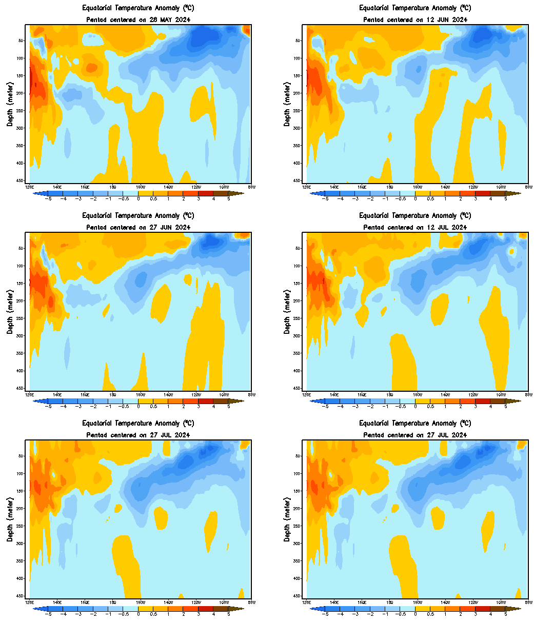
05OCT2016 -0.9
12OCT2016 -0.6
19OCT2016 -0.6
26OCT2016 -0.8
02NOV2016 -0.8
09NOV2016 -0.7
16NOV2016 -0.4
23NOV2016 -0.4


05OCT2016 -0.9
12OCT2016 -0.6
19OCT2016 -0.6
26OCT2016 -0.8
02NOV2016 -0.8
09NOV2016 -0.7
16NOV2016 -0.4
23NOV2016 -0.4
algae888- Advanced Forecaster

- Posts : 5311
Join date : 2013-02-05
 Re: Long Range Thread 12.0
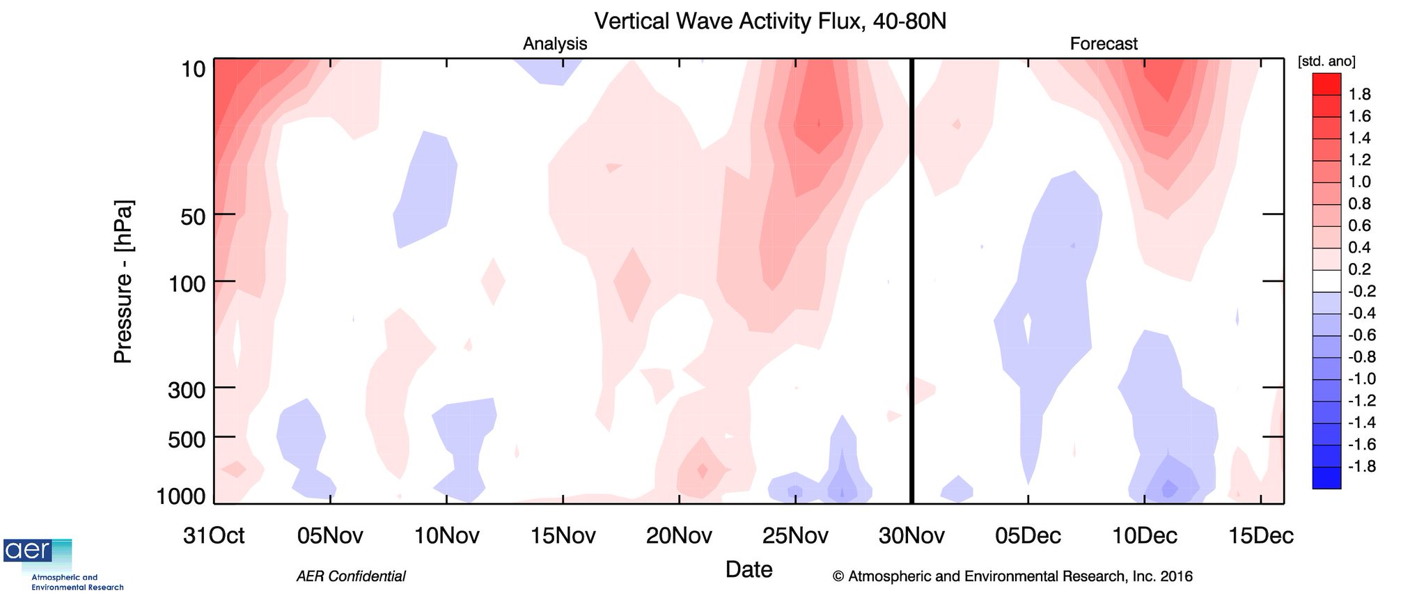
GFS forecasting a decent heat wave flux as per Dr.Cohen

_________________
Mugs
AKA:King: Snow Weenie
Self Proclaimed
WINTER 2014-15 : 55.12" +.02 for 6 coatings (avg. 35")
WINTER 2015-16 Total - 29.8" (Avg 35")
WINTER 2016-17 : 39.5" so far

amugs- Advanced Forecaster - Mod

- Posts : 15156
Reputation : 213
Join date : 2013-01-07
Age : 54
Location : Hillsdale,NJ
 Re: Long Range Thread 12.0
EPS still cold for middle to end of next week


_________________
Mugs
AKA:King: Snow Weenie
Self Proclaimed
WINTER 2014-15 : 55.12" +.02 for 6 coatings (avg. 35")
WINTER 2015-16 Total - 29.8" (Avg 35")
WINTER 2016-17 : 39.5" so far

amugs- Advanced Forecaster - Mod

- Posts : 15156
Reputation : 213
Join date : 2013-01-07
Age : 54
Location : Hillsdale,NJ
 Re: Long Range Thread 12.0
the models today are holding back the energy from the s/w trough. i'll give it another day before giving up on this one. gefs look sweet however...


algae888- Advanced Forecaster

- Posts : 5311
Reputation : 46
Join date : 2013-02-05
Age : 62
Location : mt. vernon, new york
 Re: Long Range Thread 12.0
while sun/ mon threat looks bad today we have to watc the evolution of the trough over the s/w U.S. and mexico as it moves east. the block to our north is impressive on todays euro and gaining strength. hard to see a cutter first half of next week with that look. overrunning event sure is possible imo.


algae888- Advanced Forecaster

- Posts : 5311
Reputation : 46
Join date : 2013-02-05
Age : 62
Location : mt. vernon, new york

algae888- Advanced Forecaster

- Posts : 5311
Reputation : 46
Join date : 2013-02-05
Age : 62
Location : mt. vernon, new york
 Re: Long Range Thread 12.0
So yet again my parent's internet is super slow, which means my video is delayed. It should be posted for early evening. In short, I think a light snowfall event is likely for Sunday night into Monday. Once I get back in my apartment starting tomorrow, videos will be more detailed and on time. Sorry!!!
rb924119- Meteorologist

- Posts : 7112
Reputation : 195
Join date : 2013-02-06
Age : 32
Location : Greentown, Pa
 Re: Long Range Thread 12.0
^^^ no problem Ray
From joe Cioffi

From joe Cioffi

_________________
Mugs
AKA:King: Snow Weenie
Self Proclaimed
WINTER 2014-15 : 55.12" +.02 for 6 coatings (avg. 35")
WINTER 2015-16 Total - 29.8" (Avg 35")
WINTER 2016-17 : 39.5" so far

amugs- Advanced Forecaster - Mod

- Posts : 15156
Reputation : 213
Join date : 2013-01-07
Age : 54
Location : Hillsdale,NJ
 Re: Long Range Thread 12.0
amugs wrote:^^^ no problem Ray
From joe Cioffi
That would be lovely!!

weatherwatchermom- Senior Enthusiast

- Posts : 3895
Reputation : 78
Join date : 2014-11-25
Location : Hazlet Township, NJ
 Re: Long Range Thread 12.0
Anddddd the download reset. Videos will have to wait until at least tomorrow, when I'm back in my apartment and have a GOOD internet to work with 


rb924119- Meteorologist

- Posts : 7112
Reputation : 195
Join date : 2013-02-06
Age : 32
Location : Greentown, Pa
 Re: Long Range Thread 12.0
rb924119 wrote:Anddddd the download reset. Videos will have to wait until at least tomorrow, when I'm back in my apartment and have a GOOD internet to work with

I blame global warming for your parents bad internet connection Ray.
_________________
"In weather and in life, there's no winning and losing; there's only winning and learning."
WINTER 2012/2013 TOTALS 43.65"WINTER 2017/2018 TOTALS 62.85" WINTER 2022/2023 TOTALS 4.9"
WINTER 2013/2014 TOTALS 64.85"WINTER 2018/2019 TOTALS 14.25" WINTER 2023/2024 TOTALS 13.1"
WINTER 2014/2015 TOTALS 71.20"WINTER 2019/2020 TOTALS 6.35" WINTER 2024/2025 TOTALS 0.00
WINTER 2015/2016 TOTALS 35.00"WINTER 2020/2021 TOTALS 37.75"
WINTER 2016/2017 TOTALS 42.25"WINTER 2021/2022 TOTALS 31.65"

sroc4- Admin

- Posts : 8458
Reputation : 302
Join date : 2013-01-07
Location : Wading River, LI
 Re: Long Range Thread 12.0
sroc4 wrote:rb924119 wrote:Anddddd the download reset. Videos will have to wait until at least tomorrow, when I'm back in my apartment and have a GOOD internet to work with

I blame global warming for your parents bad internet connection Ray.
Oh geeze ahaha I'm going to "No comment" on that one lmfao
rb924119- Meteorologist

- Posts : 7112
Reputation : 195
Join date : 2013-02-06
Age : 32
Location : Greentown, Pa
 Re: Long Range Thread 12.0
amugs wrote:GFS forecasting a decent heat wave flux as per Dr.Cohen
But it's in the trop region. Would like to see it in polar to have big impact.
amugs wrote:^^^ no problem Ray
From joe Cioffi
Doesn't amount to much at the surface. Maybe if we see the upper energy consolidate a bit that could spark an organized low to bring light snow accumulations, mainly N&W of NYC.
_________________
_______________________________________________________________________________________________________
CLICK HERE to view NJ Strong Snowstorm Classifications
 Re: Long Range Thread 12.0
Ever think of just using a hot spot from your phone. Often LTE is much quicker.rb924119 wrote:Anddddd the download reset. Videos will have to wait until at least tomorrow, when I'm back in my apartment and have a GOOD internet to work with

Quietace- Meteorologist - Mod

- Posts : 3689
Reputation : 33
Join date : 2013-01-07
Age : 27
Location : Point Pleasant, NJ
 Re: Long Range Thread 12.0
Models are signaling a very strong storm may develop in the center of the country. Could be a Roidzilla for parts of the Midwest. After that front comes through (around the 8th or 9th), not only do we get cold, but the -WPO takes over that could keep us cold. I still feel confident in saying the 9th to 15th will be a decent time frame for us to see a snow event. It looks like we'll have the cold, but it's still early. We'll see.
_________________
_______________________________________________________________________________________________________
CLICK HERE to view NJ Strong Snowstorm Classifications
 Re: Long Range Thread 12.0
Quietace wrote:Ever think of just using a hot spot from your phone. Often LTE is much quicker.rb924119 wrote:Anddddd the download reset. Videos will have to wait until at least tomorrow, when I'm back in my apartment and have a GOOD internet to work with

Doesn't that use a wicked amount of data, though??
rb924119- Meteorologist

- Posts : 7112
Reputation : 195
Join date : 2013-02-06
Age : 32
Location : Greentown, Pa
 Re: Long Range Thread 12.0
Does the polar vortex start coming to town around Dec 9?

dkodgis- Senior Enthusiast

- Posts : 2693
Reputation : 98
Join date : 2013-12-29
 Re: Long Range Thread 12.0
Let's take a closer look at the period after December 9th. If the potent Midwest storm comes to fruition, which could bring Godzilla snow amounts to parts of that area but rain and mild temps to the Northeast, it will be help draw down an arctic air mass into the CONUS.

Part of the reason why the Midwest is in line to see a major storm is due to the development of an anomalous -WPO. A ridge in the west Pacific, near the Aleutian Islands, allows upper energy to dig into the west CONUS (-PNA) and phase with southern stream energy. As a result, a deep low pressure system forms in the middle of the country and a ridge blossoms over the east coast. While NYC Metro is likely to receive rain, some models are hinting that the primary low in the Midwest could transfer to a secondary as it "feels" the PV to its north (marked on image). This could put Upstate NY and New England in line for a major snowstorm around the 9th. After the front comes through, winds turn to the NW and a very cold air mass enters our area. The cold is drawn down from the cut-off ridge in the western Arctic, as well as, the strong "cutter" that affects the Midwest.

Beyond the 10th, sensible weather looks to remain normal to mainly below normal in our area. The PV is over north-central Canada (not ideal), but the original -WPO ridge is still lingering around. There is a minor hint of a -NAO developing too. Models were more robust with this signal a couple of days ago and have since backed off.
What will make or break the pattern after the 10th is whether or not that ridge in the western Arctic stays alive. A weak or non-existent ridge, like the GFS suggests, puts us back in a pattern that shift the baroclinic zone back to our west and allows storms to track west of us. A -NAO will obviously help, too. Especially if you're looking for snow and not just cold weather.

So with that said, the ECM OP tries to break down the WPO but technically that ridge in the western Arctic is more-so in the AO domain. It is a result of the -WPO from December 6th-8th. So we'll just have to keep watching the trends on that ridge in the Arctic. It really is key.

The NAO wants to stay neutral for the most part. As seen in the 500mb graphics, heights are not leaning one way or the other but do lean positive toward the middle of the month. I never hold out hope for this teleconnection. Unfortunately the state of the Stratosphere would promote a +NAO over -NAO, so I would choose the former before the latter.

Day 8 to 13 850mb temps show the cold that will filter across the northern CONUS to the coast. Moral of the story is, we know it will get cold for a few days but will there be a snowstorm to accompany it? That is very hard to say at this time. There is a chance the MJO comes out of the COD (circle of death) by then, but if it does, it could be into phases 5 or 6. A phase 6 MJO during La Nina episodes call for a -WPO/+PNA/+NAO/+AO pattern. At least that gets some of the jet streams interacting. I would take my chances with that in December.

However, the EPS are not buying that and suggest we'll see a zonal flow across the Pacific and U.S. One reason why I buy this is because the Pacific Jet will be undercutting the former -WPO ridge, while the PV in Canada will be in a location that is not conducive for a -AO. Additionally, SSTA's in the west-central PAC continue to show a strong temp gradient and the QBO remains positive. The PNA does not seem intent on going positive anytime soon either.
While it may get cold, I am struggling to see a "snow train" pattern set-up for our area right now. And if the ridge in the Arctic decays completely, we'll go back into a pattern that we're in now. Cold & Dry or Mild & Wet...the worst. But I hope that will not be the case and we get help from the MJO or the NAO post December 9th.
Enjoy your night.

Part of the reason why the Midwest is in line to see a major storm is due to the development of an anomalous -WPO. A ridge in the west Pacific, near the Aleutian Islands, allows upper energy to dig into the west CONUS (-PNA) and phase with southern stream energy. As a result, a deep low pressure system forms in the middle of the country and a ridge blossoms over the east coast. While NYC Metro is likely to receive rain, some models are hinting that the primary low in the Midwest could transfer to a secondary as it "feels" the PV to its north (marked on image). This could put Upstate NY and New England in line for a major snowstorm around the 9th. After the front comes through, winds turn to the NW and a very cold air mass enters our area. The cold is drawn down from the cut-off ridge in the western Arctic, as well as, the strong "cutter" that affects the Midwest.

Beyond the 10th, sensible weather looks to remain normal to mainly below normal in our area. The PV is over north-central Canada (not ideal), but the original -WPO ridge is still lingering around. There is a minor hint of a -NAO developing too. Models were more robust with this signal a couple of days ago and have since backed off.
What will make or break the pattern after the 10th is whether or not that ridge in the western Arctic stays alive. A weak or non-existent ridge, like the GFS suggests, puts us back in a pattern that shift the baroclinic zone back to our west and allows storms to track west of us. A -NAO will obviously help, too. Especially if you're looking for snow and not just cold weather.

So with that said, the ECM OP tries to break down the WPO but technically that ridge in the western Arctic is more-so in the AO domain. It is a result of the -WPO from December 6th-8th. So we'll just have to keep watching the trends on that ridge in the Arctic. It really is key.

The NAO wants to stay neutral for the most part. As seen in the 500mb graphics, heights are not leaning one way or the other but do lean positive toward the middle of the month. I never hold out hope for this teleconnection. Unfortunately the state of the Stratosphere would promote a +NAO over -NAO, so I would choose the former before the latter.

Day 8 to 13 850mb temps show the cold that will filter across the northern CONUS to the coast. Moral of the story is, we know it will get cold for a few days but will there be a snowstorm to accompany it? That is very hard to say at this time. There is a chance the MJO comes out of the COD (circle of death) by then, but if it does, it could be into phases 5 or 6. A phase 6 MJO during La Nina episodes call for a -WPO/+PNA/+NAO/+AO pattern. At least that gets some of the jet streams interacting. I would take my chances with that in December.

However, the EPS are not buying that and suggest we'll see a zonal flow across the Pacific and U.S. One reason why I buy this is because the Pacific Jet will be undercutting the former -WPO ridge, while the PV in Canada will be in a location that is not conducive for a -AO. Additionally, SSTA's in the west-central PAC continue to show a strong temp gradient and the QBO remains positive. The PNA does not seem intent on going positive anytime soon either.
While it may get cold, I am struggling to see a "snow train" pattern set-up for our area right now. And if the ridge in the Arctic decays completely, we'll go back into a pattern that we're in now. Cold & Dry or Mild & Wet...the worst. But I hope that will not be the case and we get help from the MJO or the NAO post December 9th.
Enjoy your night.
_________________
_______________________________________________________________________________________________________
CLICK HERE to view NJ Strong Snowstorm Classifications
 Re: Long Range Thread 12.0
The forcing mechanism for the poleward dateline ridging is present (e.g., retracted jet/low GWO, Rossby wave trains via -VP), and this should persist for at least a couple weeks. However, what will be the mechanism for -NAO initiation and subsequently maintenance? The most integral determinants of NAO modulation are not conducive for protracted blocking. The most favorable signal we have presently -- in addition to the Aleutian ridge forcing -- is the repressed stratospheric vortex condition. That being said, the default at this time of year is rapid polar night jet intensification due to the perpetual darkness and thermal gradients; in the absence of robust perturbation and wave driving, the vortex will strengthen (and strengthen it will do). Consequently, throughout the 2 week forecast period, we note that the ECMWF ensembles are generally suggestive of a near neutral NAM/NAO, possibly even slightly positive by week 2. My winter outlook idea was for the mid dec-early jan period offering windows, but we will need AO/NAO cooperation in order to achieve anything greater than light accumulations for the coast. For those who remember the ECMWF ensembles from several days ago -- I didn't save them, but the Dec 1-10 period now features predominately near to above normal heights along the East Coast. 60F will occur again in about a week. For those expecting a cold to very cold December, we will likely enter mid December with a positive departure for the East Coast stations. That usually doesn't bode well for a very cold December. I expected near normal, and I'm fine with that for now. The poleward ridge will effectuate some significant CONUS cooling which should bleed east in waves, but resistance will be robust in the East due to largely insufficient downstream geopotential height rises. I see quite a few posts noting that the pattern is improving. It is -- and this could be somewhat semantics/phraseology -- but the resultant pattern could be more painful, along the lines of Nina-esque Decembers in which most of the country is cold coupled with mostly unfavorably tracking cyclones. We can guarantee that Dec 1-10th is inland runner/cutter prone, and I would say if today's D10-15 ECMWF ensembles are reliable, that pattern could also produce an inland runner fairly easily. I still think we'll get snow (by we'll I mean the coast) in the second half of December, but the extent to which the pattern is snowy will be highly dependent upon the Arctic/Atlantic. Otherwise, it's an interior wintry pattern overall. I wouldn't expect anything more than maybe a very light event before the 15th at the coast.
What do I want to see? I'd like to see renewed attacks on the stratospheric vortex, which I don't foresee right now, but that can change. At this time of year, you can't kick the vortex once and expect zonal reversal; you need incessant perturbation.
What do I want to see? I'd like to see renewed attacks on the stratospheric vortex, which I don't foresee right now, but that can change. At this time of year, you can't kick the vortex once and expect zonal reversal; you need incessant perturbation.
 Re: Long Range Thread 12.0
Nice, Frank. Unfortunately, we agree. Interesting that we broached similar points regarding the worry for an even more painful pattern w/ cold --> warm/wet ala Nina-esque proclivities. December 2007 comes to mind. Hopefully we continue to see some favorable wave driving, but with the poleward ridge at such a western longitude, this regime will not be effective without downstream support.
 Re: Long Range Thread 12.0
Great discussion fellas. I wish I could disagree with you
_________________
"In weather and in life, there's no winning and losing; there's only winning and learning."
WINTER 2012/2013 TOTALS 43.65"WINTER 2017/2018 TOTALS 62.85" WINTER 2022/2023 TOTALS 4.9"
WINTER 2013/2014 TOTALS 64.85"WINTER 2018/2019 TOTALS 14.25" WINTER 2023/2024 TOTALS 13.1"
WINTER 2014/2015 TOTALS 71.20"WINTER 2019/2020 TOTALS 6.35" WINTER 2024/2025 TOTALS 0.00
WINTER 2015/2016 TOTALS 35.00"WINTER 2020/2021 TOTALS 37.75"
WINTER 2016/2017 TOTALS 42.25"WINTER 2021/2022 TOTALS 31.65"

sroc4- Admin

- Posts : 8458
Reputation : 302
Join date : 2013-01-07
Location : Wading River, LI
 Re: Long Range Thread 12.0
Less than you think. I have to use it a lot up here as the wireless fails more often than it should. Up/down is really bad as well.rb924119 wrote:Quietace wrote:Ever think of just using a hot spot from your phone. Often LTE is much quicker.rb924119 wrote:Anddddd the download reset. Videos will have to wait until at least tomorrow, when I'm back in my apartment and have a GOOD internet to work with

Doesn't that use a wicked amount of data, though??

Quietace- Meteorologist - Mod

- Posts : 3689
Reputation : 33
Join date : 2013-01-07
Age : 27
Location : Point Pleasant, NJ
 Re: Long Range Thread 12.0
Nice fantasys been popping up for the 11-17th timeframe on the models, todays 6z GFS has a nice one. Gonna check tellies.
NjWeatherGuy- Advanced Forecaster

- Posts : 4100
Reputation : 28
Join date : 2013-01-06
Location : Belle Mead, NJ
 Re: Long Range Thread 12.0
I'll take getting colder as a W, as long as by Christmas it's not in the 60's again..

RJB8525- Senior Enthusiast

- Posts : 1994
Reputation : 28
Join date : 2013-02-06
Age : 38
Location : Hackettstown, NJ
 Re: Long Range Thread 12.0
Their seems to a lot of uncertainty with a colder snowy pattern

skinsfan1177- Senior Enthusiast

- Posts : 4485
Reputation : 35
Join date : 2013-01-07
Age : 47
Location : Point Pleasant Boro
 Re: Long Range Thread 12.0
My call for December is -1 to -2 for New York City with near average snowfall. We will be near to below normal on December 15th with our first snowfall by then. Interior much better. Colder second half of the month. I like the negative wpo and the anomolous ridge there with the polar vortex setting up on our side of the globe. Cross polar flow. Tough to break that ridge that the ensembles are showing once it forms. I don't see any warmth except prior to Cutters and I don't see any sustained cold which lasts two weeks or more. Very up-and-down for December which is by far better than any of the last several Years.

algae888- Advanced Forecaster

- Posts : 5311
Reputation : 46
Join date : 2013-02-05
Age : 62
Location : mt. vernon, new york
Page 28 of 40 •  1 ... 15 ... 27, 28, 29 ... 34 ... 40
Page 28 of 40
Permissions in this forum:
You cannot reply to topics in this forum
 Home
Home
