Long Range Thread 12.0
+30
StatenWx
Dunnzoo
weatherwatchermom
Quietace
dkodgis
mwilli5783
jrollins628
devsman
skinsfan1177
billg315
jmanley32
Snow88
chief7
Dtone
Isotherm
sroc4
docstox12
CPcantmeasuresnow
frank 638
track17
NjWeatherGuy
HectorO
SNOW MAN
rb924119
Math23x7
algae888
snow247
amugs
nutleyblizzard
Frank_Wx
34 posters
Page 31 of 40
Page 31 of 40 •  1 ... 17 ... 30, 31, 32 ... 35 ... 40
 Re: Long Range Thread 12.0
hyde345 wrote:Really can't trust any of these models beyond 5 days. 6z and 12z runs of GFS look like night and day in LR.
Ain't that the truth.
Today's 12z GFS now shows a +EPO/+NAO developing which would allow storms to continue cutting to our west, keeping us mild and dry. It would be a Mild-Rain-Cold pattern.
 Re: Long Range Thread 12.0
Frank, it looks like a wave-2 pulse within 2 SD of the mean, which is fairly typical in terms of the usual wave activity. We'll probably elongate the vortex for a time, but I don't think we'll have sufficient driving to sustain the assault or induce collapse.
Also, note the tropospheric teleconnections now indicating a +NAO/AO in the medium term on the ECMWF ensembles, reflective of the rapidly strengthening z10 zonal winds.

Also, note the tropospheric teleconnections now indicating a +NAO/AO in the medium term on the ECMWF ensembles, reflective of the rapidly strengthening z10 zonal winds.

 Re: Long Range Thread 12.0
Some could argue that run of the 12z GFS was off. Here were the 00z and 06z GFS analog composites.


Now look at the 12z


Now look at the 12z

_________________
_______________________________________________________________________________________________________
CLICK HERE to view NJ Strong Snowstorm Classifications
 Re: Long Range Thread 12.0
I'm away for the weekend just wanted to chime in great discussions on the previous pages anyway all the models lost the intense cutter for this coming week. Instead they now have a wave forming on the front somewhere near the coast around Thursday. Potential for snow that day also. Anyone looking for any warm up sometime this week will be disappionted. After the cold front we can expect some well below normal temperatures for at least several days. I'm starting to feel my December forecast is too warm especially for the first half. Fun times ahead

algae888- Advanced Forecaster

- Posts : 5311
Reputation : 46
Join date : 2013-02-05
Age : 62
Location : mt. vernon, new york
 Re: Long Range Thread 12.0
A real wintry week coming up especially for Inland areas.

algae888- Advanced Forecaster

- Posts : 5311
Reputation : 46
Join date : 2013-02-05
Age : 62
Location : mt. vernon, new york
 Re: Long Range Thread 12.0
7 year cycle for dec. 95, 02, 09,. 16?.

algae888- Advanced Forecaster

- Posts : 5311
Reputation : 46
Join date : 2013-02-05
Age : 62
Location : mt. vernon, new york
 Re: Long Range Thread 12.0
It's going to be cold and wintry this week for sure, especially N&W areas, but the LR leaves much to be desired still.
_________________
_______________________________________________________________________________________________________
CLICK HERE to view NJ Strong Snowstorm Classifications
 Re: Long Range Thread 12.0
Frank_Wx wrote:Some could argue that run of the 12z GFS was off. Here were the 00z and 06z GFS analog composites.
Now look at the 12z
The GEFS do not match the OP at all in the LR, which is a good thing. GEFS keep us very cold.
_________________
_______________________________________________________________________________________________________
CLICK HERE to view NJ Strong Snowstorm Classifications
 Re: Long Range Thread 12.0
It is a cold look on the long range GEFS. I keep saying we need help from one of the PNA or NAO because the EPO alone will not do it. The GEFS think the NAO may go negative mid-month. Let's hope!

_________________
_______________________________________________________________________________________________________
CLICK HERE to view NJ Strong Snowstorm Classifications
 Re: Long Range Thread 12.0
EurEuro mean showing possible miller b solution


_________________
Mugs
AKA:King: Snow Weenie
Self Proclaimed
WINTER 2014-15 : 55.12" +.02 for 6 coatings (avg. 35")
WINTER 2015-16 Total - 29.8" (Avg 35")
WINTER 2016-17 : 39.5" so far

amugs- Advanced Forecaster - Mod

- Posts : 15156
Reputation : 213
Join date : 2013-01-07
Age : 54
Location : Hillsdale,NJ
 Re: Long Range Thread 12.0
Do Miller B give coastal areas a good chance for snow or is that Miller A

skinsfan1177- Senior Enthusiast

- Posts : 4485
Reputation : 35
Join date : 2013-01-07
Age : 47
Location : Point Pleasant Boro
 Re: Long Range Thread 12.0
Miller B storms tend to favor New England, but as long as there is enough blocking we can do well too.
_________________
_______________________________________________________________________________________________________
CLICK HERE to view NJ Strong Snowstorm Classifications
 Re: Long Range Thread 12.0
18z GFS is very close also for day 5 http://www.stormvistawxmodels.com/img/gfs/current/18z/GFS_MSLPThickQPF_na_f120.png?1364096147

Snow88- Senior Enthusiast

- Posts : 2193
Reputation : 4
Join date : 2013-01-09
Age : 36
Location : Brooklyn, NY
 Re: Long Range Thread 12.0
I am getting a tad excited about the storm on the 12th. It will depend on what happens with the storm on the 8th/9th. In my opinion, we want the storm on the 8th to deepen as much as possible because it acts as our 50/50 low. Helps slow the flow down and organize a low pressure system off the coast on the 12th as energy ejects out of Canada. Look at how strong that ridge is in the western Arctic. Between that and the 50/50 Low, I think we have the ingredients here to see our first major snowfall of the season. LONG way to go and my confidence is low at this juncture, but better than nothing!

_________________
_______________________________________________________________________________________________________
CLICK HERE to view NJ Strong Snowstorm Classifications
 Re: Long Range Thread 12.0
I should add that we do not want to dampen heights too much along the east coast, or the storm on the 12th will be at risk of shearing out or being weak. We need just the right height rise and perfect timing of upper energy.
_________________
_______________________________________________________________________________________________________
CLICK HERE to view NJ Strong Snowstorm Classifications
 Re: Long Range Thread 12.0
This morning guidance is going back to the idea that the 12th - 18th will be a transient period of cold, as the EPO/AO go positive by the 19th and puts us back in a mild pattern.

_________________
_______________________________________________________________________________________________________
CLICK HERE to view NJ Strong Snowstorm Classifications
 Re: Long Range Thread 12.0
gefs lost the goa vortex and now has a nice -nao. models will continue to waffle in the lr. if the -wpo ridge does build like advertised it could stay for awhile. wouldn't count on it breaking down too quickly or if it does it could come right back..Frank_Wx wrote:This morning guidance is going back to the idea that the 12th - 18th will be a transient period of cold, as the EPO/AO go positive by the 19th and puts us back in a mild pattern.


algae888- Advanced Forecaster

- Posts : 5311
Reputation : 46
Join date : 2013-02-05
Age : 62
Location : mt. vernon, new york
 Re: Long Range Thread 12.0
I do not recall any winter forecast with this happening. neutral + for rest of winter?
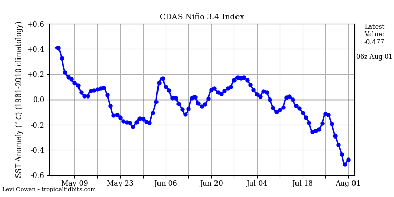
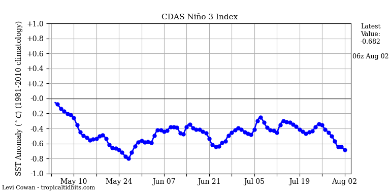

add in +pdo. do not recall many winter forecast showing that.


add in +pdo. do not recall many winter forecast showing that.

algae888- Advanced Forecaster

- Posts : 5311
Reputation : 46
Join date : 2013-02-05
Age : 62
Location : mt. vernon, new york
 Re: Long Range Thread 12.0
this year the strat (record weak pv and very early to add) seems to be the main player imo. just look at the cold on the other side of the globe in nov.and the forecast cold coming to our side. add in anomalous HP in various areas of the arctic with record low sea ice and we have an atmosphere that is hard to match up to previous years and could end up surprising many by winters end. this with a +qbo! and gaining strength! ODD! so when does the vortex strengthen? I am far from an expert with regards to the strat but just maybe it stays weak all winter and remains vulnerable. very interesting.


algae888- Advanced Forecaster

- Posts : 5311
Reputation : 46
Join date : 2013-02-05
Age : 62
Location : mt. vernon, new york
 Re: Long Range Thread 12.0
I could play word association just to show how many variations there are to weather:
climatology-fossil records
sun-sun spots
meteorology-analog/digital
atmospheric sciences-stratosphere, troposphere, polar vortex
The weather is just plain contrary and difficult to prognosticate.
climatology-fossil records
sun-sun spots
meteorology-analog/digital
atmospheric sciences-stratosphere, troposphere, polar vortex
The weather is just plain contrary and difficult to prognosticate.

dkodgis- Senior Enthusiast

- Posts : 2693
Reputation : 98
Join date : 2013-12-29
 Re: Long Range Thread 12.0
algae888 wrote:I do not recall any winter forecast with this happening. neutral + for rest of winter?
add in +pdo. do not recall many winter forecast showing that.
I had La Nina collapsing by mid-winter in my outlook
From my outlook:
Statistical models are under the impression La Nina will peak in November and gradually rise to ENSO-neutral conditions through the winter. This would suggest ENSO is unlikely to play a key role in our winter weather pattern since neutral conditions over the Tropical Pacific do not have an influence on our winter pattern in the U.S. Instead, the factors I outlined early on in the blog such as PDO, Stratosphere, etc. would be our main drivers.
The evidence is quite clear between the statistical models and the ONI / SOI trends over the last few weeks, La Nina will remain weak and possibly dissipate by the middle to end of winter.
_________________
_______________________________________________________________________________________________________
CLICK HERE to view NJ Strong Snowstorm Classifications
 Re: Long Range Thread 12.0
algae888 wrote:this year the strat (record weak pv and very early to add) seems to be the main player imo. just look at the cold on the other side of the globe in nov.and the forecast cold coming to our side. add in anomalous HP in various areas of the arctic with record low sea ice and we have an atmosphere that is hard to match up to previous years and could end up surprising many by winters end. this with a +qbo! and gaining strength! ODD! so when does the vortex strengthen? I am far from an expert with regards to the strat but just maybe it stays weak all winter and remains vulnerable. very interesting.
While the Strat PV is weak, mean zonal winds are expected to strengthen in the coming days. This points to a strengthening Strat PV.

Tropospheric PV following suite

_________________
_______________________________________________________________________________________________________
CLICK HERE to view NJ Strong Snowstorm Classifications
 Re: Long Range Thread 12.0
Agreed, Frank. Not much to add at this point. We'll see how the next week progresses. I'm not optimistic about this pattern. There's always a chance that a transient block develops, and we sneak in an event within an overall poor pattern.
I was looking through Ray's archive. 1998-99, a terrible snow year, managed to pull off a white Christmas it appears for my area with 2-4":
http://www.raymondcmartinjr.com/weather/1999/24-Dec-98.html
Talk about lucky timing. My hopes were not high going into this winter, but if we managed a white Christmas, that would provide some satisfaction. Last one was 2009 (near miss 2010).
 Re: Long Range Thread 12.0
Yup, give me a white Christmas and mother nature can do whatever the heck she wants.
_________________
_______________________________________________________________________________________________________
CLICK HERE to view NJ Strong Snowstorm Classifications
 Re: Long Range Thread 12.0
GFS has some snow with a gradient look for next week

Snow88- Senior Enthusiast

- Posts : 2193
Reputation : 4
Join date : 2013-01-09
Age : 36
Location : Brooklyn, NY
 Re: Long Range Thread 12.0
Isotherm wrote:Agreed, Frank. Not much to add at this point. We'll see how the next week progresses. I'm not optimistic about this pattern. There's always a chance that a transient block develops, and we sneak in an event within an overall poor pattern.
I was looking through Ray's archive. 1998-99, a terrible snow year, managed to pull off a white Christmas it appears for my area with 2-4":
http://www.raymondcmartinjr.com/weather/1999/24-Dec-98.html
Talk about lucky timing. My hopes were not high going into this winter, but if we managed a white Christmas, that would provide some satisfaction. Last one was 2009 (near miss 2010).
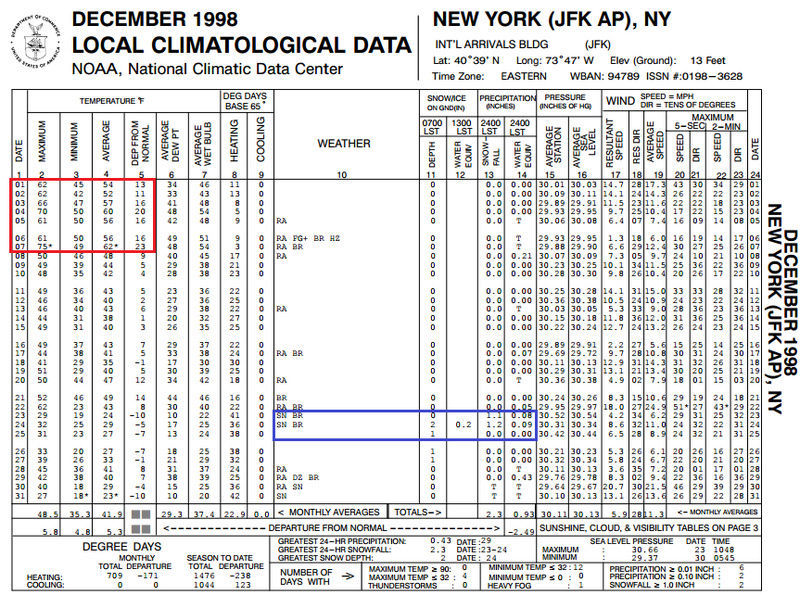
I remember that well. In fact, that was actually the first winter after which I became interested in weather. I remember on this day that December (the 4th), I was home sick. That afternoon, my mother said to me (I was 8 years old at the time) that it was 70 degrees. It was stunning for me to hear that it could get that warm in December in New York. In fact, much of that month was warm, at the time the second warmest December on record (It has since dropped to 6th warmest). Then I woke up the morning of December 24th to see the beautiful snow on the ground. It felt like a Christmas miracle that we had a white Christmas after all! The next day,, Christmas morning, had sunshine over a winter wonderland! Of course, the snow would melt away days later. But we did had two other snow events that winter which I remember playing in the snow: 1/8/99 and 3/15/99, the latter featuring the heaviest snow of the winter. So while it may not have been a big winter climatologically speaking, those three events were enough to fulfill me as a kid.
A lot of comparisons were made to this winter, mainly because we're coming off a Strong El Nino, but since we may not get the La Nina, I'm not sure if this can be a 1998-99 redux.
By the way, here was December 1998 for JFK airport (the NWS station closest to me) which illustrates the wild December we had:
Math23x7- Wx Statistician Guru

- Posts : 2382
Reputation : 68
Join date : 2013-01-08
 Re: Long Range Thread 12.0
Seems like the 12th now looks like a huge cuter along with every other storm the next 16 days. I hope tgats not the case. Are you no longer thinking good storm around 12th frank?

jmanley32- Senior Enthusiast

- Posts : 20646
Reputation : 108
Join date : 2013-12-12
Age : 43
Location : Yonkers, NY
Page 31 of 40 •  1 ... 17 ... 30, 31, 32 ... 35 ... 40
Page 31 of 40
Permissions in this forum:
You cannot reply to topics in this forum
 Home
Home