Long Range Thread 12.0
+30
StatenWx
Dunnzoo
weatherwatchermom
Quietace
dkodgis
mwilli5783
jrollins628
devsman
skinsfan1177
billg315
jmanley32
Snow88
chief7
Dtone
Isotherm
sroc4
docstox12
CPcantmeasuresnow
frank 638
track17
NjWeatherGuy
HectorO
SNOW MAN
rb924119
Math23x7
algae888
snow247
amugs
nutleyblizzard
Frank_Wx
34 posters
Page 38 of 40
Page 38 of 40 •  1 ... 20 ... 37, 38, 39, 40
 Re: Long Range Thread 12.0
50 deg is depressing I was hoping for little snow for Xmas enough with this warm mild weather crap
frank 638- Senior Enthusiast

- Posts : 2882
Join date : 2016-01-01
 Re: Long Range Thread 12.0
CPcantmeasuresnow wrote:Frank_Wx wrote:Temps Christmas Day are likely to be +3 to +6 above normal. Not thinking 60's or 70's. We'll see if we crack 50 this year but most likely upper 40's.
Still long ways off. If a front comes through quicker than expected than naturally cold air will filter behind and we'll be in the 30's.
Even upper 40's is 8-12 degrees above normal for the city and N & W suburbs, I'll take it over last year but it's still a scroo job.
Maybe for NJ suburbs but that's about normal technically for the city. The city's average isn't 35 or 30 yet for this time.
HectorO- Pro Enthusiast

- Posts : 977
Join date : 2013-01-11
 Re: Long Range Thread 12.0
Weekend looks snowier onthe GFS and CMC

Snow88- Senior Enthusiast

- Posts : 2193
Reputation : 4
Join date : 2013-01-09
Age : 36
Location : Brooklyn, NY
 Re: Long Range Thread 12.0
HectorO wrote:CPcantmeasuresnow wrote:Frank_Wx wrote:Temps Christmas Day are likely to be +3 to +6 above normal. Not thinking 60's or 70's. We'll see if we crack 50 this year but most likely upper 40's.
Still long ways off. If a front comes through quicker than expected than naturally cold air will filter behind and we'll be in the 30's.
Even upper 40's is 8-12 degrees above normal for the city and N & W suburbs, I'll take it over last year but it's still a scroo job.
Maybe for NJ suburbs but that's about normal technically for the city. The city's average isn't 35 or 30 yet for this time.
We were talking about Christmas Day.
The average temperature in Central Park on Christmas day is a high of 40 and a low of 29. For Orange County it's 36 and 18 so I stick with what I said, upper 40's would be 8-12 degrees above normal for Christmas Day for NYC and N & W suburbs.
NYC is the aberration not the normal in our area.

CPcantmeasuresnow- Wx Statistician Guru

- Posts : 7288
Reputation : 230
Join date : 2013-01-07
Age : 103
Location : Eastern Orange County, NY
 Re: Long Range Thread 12.0
Weekedn Storm Mean on GEFS - very nice - coming in at night on Fiday into dense arctic air - looks like a nice storm N&W


_________________
Mugs
AKA:King: Snow Weenie
Self Proclaimed
WINTER 2014-15 : 55.12" +.02 for 6 coatings (avg. 35")
WINTER 2015-16 Total - 29.8" (Avg 35")
WINTER 2016-17 : 39.5" so far

amugs- Advanced Forecaster - Mod

- Posts : 15156
Reputation : 213
Join date : 2013-01-07
Age : 54
Location : Hillsdale,NJ
 Re: Long Range Thread 12.0
PAC going to be an ally as we head into this warm period - need teh PAC and it may come to the help of us easterners!!


_________________
Mugs
AKA:King: Snow Weenie
Self Proclaimed
WINTER 2014-15 : 55.12" +.02 for 6 coatings (avg. 35")
WINTER 2015-16 Total - 29.8" (Avg 35")
WINTER 2016-17 : 39.5" so far

amugs- Advanced Forecaster - Mod

- Posts : 15156
Reputation : 213
Join date : 2013-01-07
Age : 54
Location : Hillsdale,NJ
 Re: Long Range Thread 12.0
Mugs the last few runs of the GFS ensembles for the long range looks like the positive EPO Nao doesn't last long as its trying to build the ridge again in Alaska. To me it looks like a relaxation and then a reload and by that time we'll be in Prime climo. Besides this weekend storm we have a shot next week with more snow esp early on as we will have another Arctic air mass In-Place Monday Tuesday Wednesday as you have pointed out in the banter thread. I still see KNYC -2 for the month with near normal snowfall although the snowfall that we get will be more of a mixed eventsamugs wrote:PAC going to be an ally as we head into this warm period - need teh PAC and it may come to the help of us easterners!!

algae888- Advanced Forecaster

- Posts : 5311
Reputation : 46
Join date : 2013-02-05
Age : 62
Location : mt. vernon, new york
 Re: Long Range Thread 12.0
^^ Al - I see this as a 2013-14 set up where we had a warm up before the hammer drops again IMO . Negative EPO will build - I am not 100% on the PNA going Positive but hopefully neutral overall - looks like a Scandinavian Ridge will build which will help with the flow just like 2013-14 and may just allow for a wave 2 attack on the STRAT. We may be plus 3 for the week before we flip back which may be the looks like the last week of December.
AAM going Negative which is a good sign and trop forcing looks to build out at the dateline

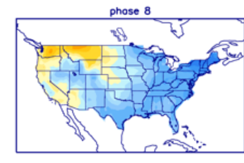
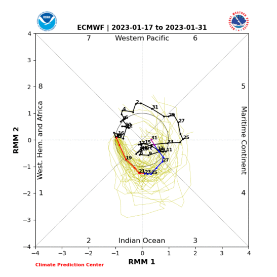
MJO still in COD but leaning to phase 7/8 here - IF it comes out in phase 8 this will help us going forward
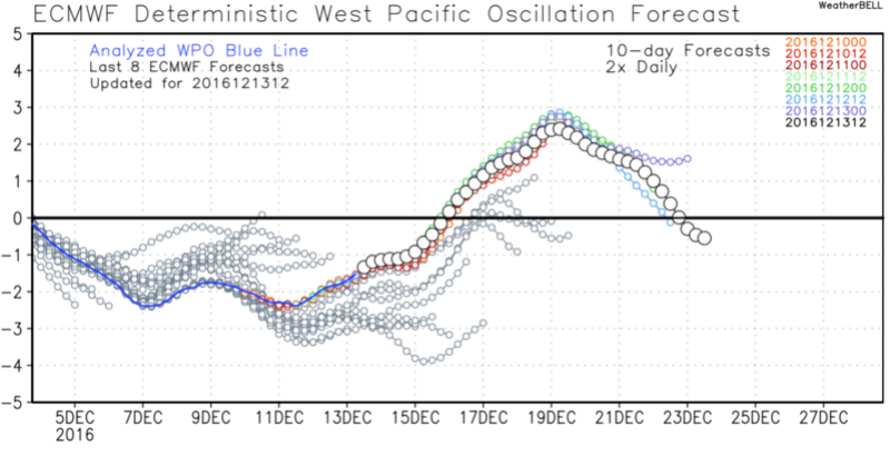
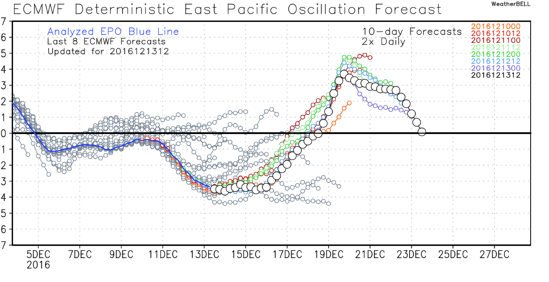
BTW PAC map I posted showing teh wavy rollercoaster troughs and ridges are going to slow the flow down as well. The ridge trying regain itself in the WPO adn EPO regions are a good sign in the LR
WPO
EPO

AAM going Negative which is a good sign and trop forcing looks to build out at the dateline

MJO still in COD but leaning to phase 7/8 here - IF it comes out in phase 8 this will help us going forward


BTW PAC map I posted showing teh wavy rollercoaster troughs and ridges are going to slow the flow down as well. The ridge trying regain itself in the WPO adn EPO regions are a good sign in the LR
WPO

EPO


_________________
Mugs
AKA:King: Snow Weenie
Self Proclaimed
WINTER 2014-15 : 55.12" +.02 for 6 coatings (avg. 35")
WINTER 2015-16 Total - 29.8" (Avg 35")
WINTER 2016-17 : 39.5" so far

amugs- Advanced Forecaster - Mod

- Posts : 15156
Reputation : 213
Join date : 2013-01-07
Age : 54
Location : Hillsdale,NJ
 Re: Long Range Thread 12.0
algae888 wrote:Mugs the last few runs of the GFS ensembles for the long range looks like the positive EPO Nao doesn't last long as its trying to build the ridge again in Alaska. To me it looks like a relaxation and then a reload and by that time we'll be in Prime climo. Besides this weekend storm we have a shot next week with more snow esp early on as we will have another Arctic air mass In-Place Monday Tuesday Wednesday as you have pointed out in the banter thread. I still see KNYC -2 for the month with near normal snowfall although the snowfall that we get will be more of a mixed eventsamugs wrote:PAC going to be an ally as we head into this warm period - need teh PAC and it may come to the help of us easterners!!
Your going against 17 straight months of above normal Al, I hope you're right.

CPcantmeasuresnow- Wx Statistician Guru

- Posts : 7288
Reputation : 230
Join date : 2013-01-07
Age : 103
Location : Eastern Orange County, NY
 Re: Long Range Thread 12.0
Cp 2 artics blasts one tom. and one monday although not as brutal. We will be minus 3 by the 20th. That means we have to average +6 the last 11 days. While there will days of + 6 there also be a few below normal days in there so a negative December looks extremely likely at the moment.

algae888- Advanced Forecaster

- Posts : 5311
Reputation : 46
Join date : 2013-02-05
Age : 62
Location : mt. vernon, new york
 Re: Long Range Thread 12.0
Mugsy - I am talking about the Saturday storm in the December thread since technically it's not long range anymore. I will start a thread on it later. Working late today.
_________________
_______________________________________________________________________________________________________
CLICK HERE to view NJ Strong Snowstorm Classifications
 Re: Long Range Thread 12.0
Frank_Wx wrote:Mugsy - I am talking about the Saturday storm in the December thread since technically it's not long range anymore. I will start a thread on it later. Working late today.
EXCELLENT - was going to start one but I was arse backwards today -
_________________
Mugs
AKA:King: Snow Weenie
Self Proclaimed
WINTER 2014-15 : 55.12" +.02 for 6 coatings (avg. 35")
WINTER 2015-16 Total - 29.8" (Avg 35")
WINTER 2016-17 : 39.5" so far

amugs- Advanced Forecaster - Mod

- Posts : 15156
Reputation : 213
Join date : 2013-01-07
Age : 54
Location : Hillsdale,NJ
 Re: Long Range Thread 12.0
The more I look at the medium to long range the less I'm inclined to believe this month will finish much above normal. Instead, I think December will end at normal (-1 to +1). I did not forecast in my winter outlook December to finish above normal, in fact I said this will be the coldest month of the winter, but sentiment around the weather community seems to be its been a warm month when it really hasn't been. Extreme cold the next few days followed by some cutters with more cold filtering behind will likely juggle temp departures from normal between +3 to -2 (you get the gist) and when all is said and done the month will finish around normal in my opinion.
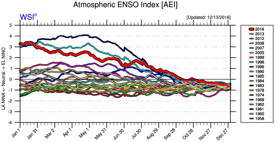
I saw this graphic from Ventrice and found it interesting. His atmospheric ENSO index, which is a tool he has to show which ENSO state our atmosphere is responding to, says our atmosphere did not descend to La Nina status until the Halloween time frame. Considering negative ONI values have persisted since the summer, one would think our atmosphere entered La Nina sometime in late fall. I'm not sure how accurate this tool is, but it goes to show the toll the El Nino of last winter took on our atmosphere.
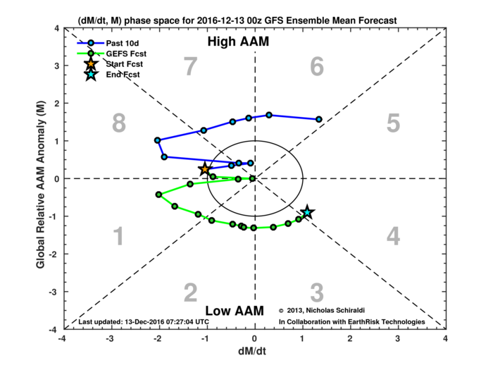
Some folks were talking about tropical forcing and how that could lend to colder than normal weather returning to the Northeast around New Years or early January. While I'm not discounting it, it's important to note that models show tropical forcing in the long range and it's no guarantee it comes to fruition. Further, upward motion is non-existent over the Dateline (typical of La Nina years anyway) and AAM is not really showing positive but more neutral conditions in the long range. It would still have an impact on our pattern though, so we'll see how true this is.
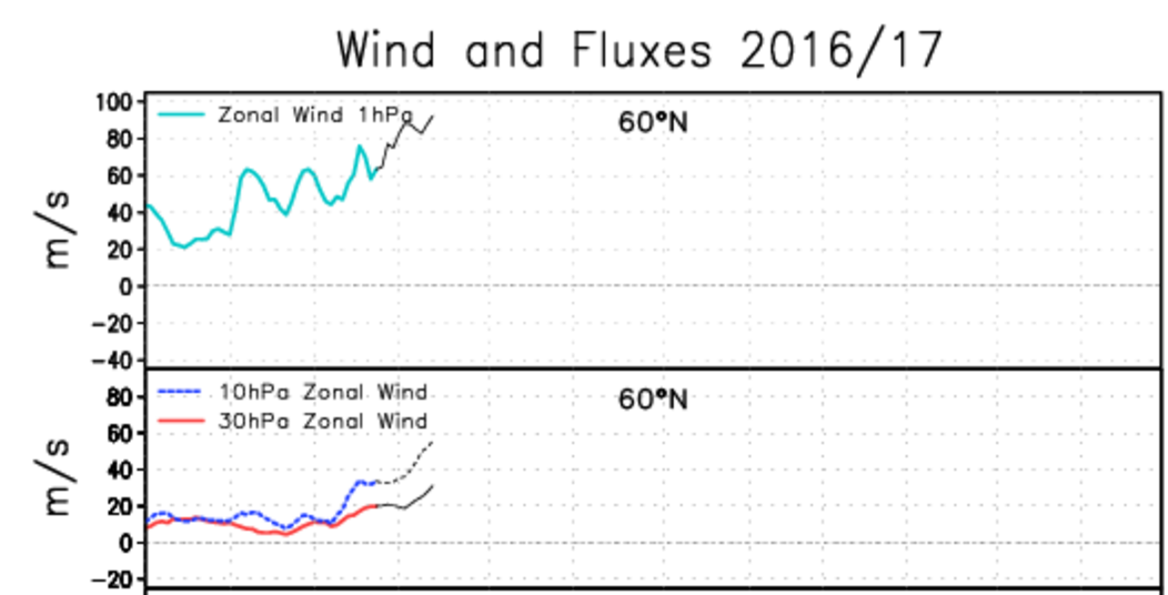
Lastly, 1hPa, 10hPa, and 30hPa Stratospheric mean zonal winds continue to rise, or show intense westerly winds. Without a wave breaking pattern in sight to transport warmth into the Stratosphere, the PV will continue to intensify in the coming days and weeks. What's interesting is some knowledgeable people in this field feel it's not bad news this is happening to the Strat PV. Their thoughts are if the PV were to stay weaker than normal through December, it would not produce a huge feedback (or SSWE) impressive enough to impact our AO. As long as we're able to see mean zonal winds reverse in time (by Week 2 or Week 3 of January) then the SSWE could be more impressive with a PV in a strong state as opposed to one in a weak state.
In my opinion, it sounds risky to say one prefers a stronger PV over a weak one because we saw what a strong PV brought with it last year but I understand the logic. With snow cover in North America recovering, and SCE continuing to grow in the Northern Hemisphere, I remain hopeful WAF increases in time to achieve a SSWE by mid-January.

I saw this graphic from Ventrice and found it interesting. His atmospheric ENSO index, which is a tool he has to show which ENSO state our atmosphere is responding to, says our atmosphere did not descend to La Nina status until the Halloween time frame. Considering negative ONI values have persisted since the summer, one would think our atmosphere entered La Nina sometime in late fall. I'm not sure how accurate this tool is, but it goes to show the toll the El Nino of last winter took on our atmosphere.

Some folks were talking about tropical forcing and how that could lend to colder than normal weather returning to the Northeast around New Years or early January. While I'm not discounting it, it's important to note that models show tropical forcing in the long range and it's no guarantee it comes to fruition. Further, upward motion is non-existent over the Dateline (typical of La Nina years anyway) and AAM is not really showing positive but more neutral conditions in the long range. It would still have an impact on our pattern though, so we'll see how true this is.

Lastly, 1hPa, 10hPa, and 30hPa Stratospheric mean zonal winds continue to rise, or show intense westerly winds. Without a wave breaking pattern in sight to transport warmth into the Stratosphere, the PV will continue to intensify in the coming days and weeks. What's interesting is some knowledgeable people in this field feel it's not bad news this is happening to the Strat PV. Their thoughts are if the PV were to stay weaker than normal through December, it would not produce a huge feedback (or SSWE) impressive enough to impact our AO. As long as we're able to see mean zonal winds reverse in time (by Week 2 or Week 3 of January) then the SSWE could be more impressive with a PV in a strong state as opposed to one in a weak state.
In my opinion, it sounds risky to say one prefers a stronger PV over a weak one because we saw what a strong PV brought with it last year but I understand the logic. With snow cover in North America recovering, and SCE continuing to grow in the Northern Hemisphere, I remain hopeful WAF increases in time to achieve a SSWE by mid-January.
_________________
_______________________________________________________________________________________________________
CLICK HERE to view NJ Strong Snowstorm Classifications
 Re: Long Range Thread 12.0
this is not a warm look on the eps as we head towards the holiday season.


notice how ridging is trying to build back in the wpo and epo regions. yes not cold but def not a torch. we can work with a +1-2 as we head into peak cold climo. to me it's a relaxation and then reload. we shall see.


notice how ridging is trying to build back in the wpo and epo regions. yes not cold but def not a torch. we can work with a +1-2 as we head into peak cold climo. to me it's a relaxation and then reload. we shall see.

algae888- Advanced Forecaster

- Posts : 5311
Reputation : 46
Join date : 2013-02-05
Age : 62
Location : mt. vernon, new york
 Re: Long Range Thread 12.0
White Xmass GFS says we have a shot


_________________
Mugs
AKA:King: Snow Weenie
Self Proclaimed
WINTER 2014-15 : 55.12" +.02 for 6 coatings (avg. 35")
WINTER 2015-16 Total - 29.8" (Avg 35")
WINTER 2016-17 : 39.5" so far

amugs- Advanced Forecaster - Mod

- Posts : 15156
Reputation : 213
Join date : 2013-01-07
Age : 54
Location : Hillsdale,NJ
 Re: Long Range Thread 12.0
I am dreaming of white Christmas lol my fingers are cross this would make up for last year's Christmas I will be happy even with two to four inches
frank 638- Senior Enthusiast

- Posts : 2882
Reputation : 37
Join date : 2016-01-01
Age : 41
Location : bronx ny
 Re: Long Range Thread 12.0
GEFS and EPS show the southeast ridge taking hold Christmas Eve and lasting through New Years. +AO/-PNA/+EPO is a killer
_________________
_______________________________________________________________________________________________________
CLICK HERE to view NJ Strong Snowstorm Classifications
 Re: Long Range Thread 12.0
What does that mean
frank 638- Senior Enthusiast

- Posts : 2882
Reputation : 37
Join date : 2016-01-01
Age : 41
Location : bronx ny
 Re: Long Range Thread 12.0
frank 638 wrote:What does that mean
Find your shorts.
_________________
_______________________________________________________________________________________________________
CLICK HERE to view NJ Strong Snowstorm Classifications
 Re: Long Range Thread 12.0
Frank_Wx wrote:
GEFS and EPS show the southeast ridge taking hold Christmas Eve and lasting through New Years. +AO/-PNA/+EPO is a killer
Thank god it has struggled this winter

Snow88- Senior Enthusiast

- Posts : 2193
Reputation : 4
Join date : 2013-01-09
Age : 36
Location : Brooklyn, NY
 Re: Long Range Thread 12.0
Snow88 wrote:Frank_Wx wrote:
GEFS and EPS show the southeast ridge taking hold Christmas Eve and lasting through New Years. +AO/-PNA/+EPO is a killer
Thank god it has struggled this winter
The GEFS and EPS when in agreement is normally good indication the modeled pattern has a good chance of coming to fruition. And the background state of our pattern (Stratosphere and ENSO) favors a warmer than normal pattern by Christmas and beyond. As I wrote yesterday, I will think December finishes near normal but the overall storm track pattern looks ugly.
_________________
_______________________________________________________________________________________________________
CLICK HERE to view NJ Strong Snowstorm Classifications
 Re: Long Range Thread 12.0

_________________
_______________________________________________________________________________________________________
CLICK HERE to view NJ Strong Snowstorm Classifications
 Re: Long Range Thread 12.0
The North Jersey Weather Observers association had a meeting and Jim Witt was our guest speaker and talked about his winter forecast - amazing the amount of information that he compiles (went back to 1876 for NYC in analogs!!!) to come up with his forecast simple as this for NYC: Keep in mind he made this forecast in September but we cancelled a meeting for his November presentation:
DEC
Normal for temps over all (+.5 ) and Slightly BN for snow fall but AN for Precip
NW of NYC BN temps and AN Snowfall
JAN
AN by about +1 for temps and BN for snowfall by about 2.5" and Slightly BN for precip
Ready for this bomb
FEB
WAYYYYYYYY BN by 8*!!!!!!!!!!!! and WAYYYYYY AN for SNOW by 7"
Why? He said that terrestrial alignment of the Earth and Uranus at a sextant angle of 60* means we will go into teh freezer for the first three weeks of Feb. - It may extend into late Jan. He said last time this occurred 1978 and I believe 2003.
MARCH goes into spring as we are AN for temps by about 4* and BN for Precip and NO SNOW
Overall NYC
Temps D-M about N give or take .5*
D-F BN by 4.6* due to Feb
D-F Snowfall AN by about 3"
D-F Precip AN by about 2"
Dates on calendar to note
12- 18-20 strong cold front
Jan 22-26 - intense storminess due to Moon, Sun, Earth and Mercury alignment - lets get Saturn in there and we can have a bomb!!
Guy is very good and HUMBLE - forecasts have basically verified each winter season since he has been forecasting his winter outlook to us these past 5 years I have been a member - 2013-14 and 14-15 he wasn't cold enough but called for AN snow but off in the metric of the amount.
_________________
Mugs
AKA:King: Snow Weenie
Self Proclaimed
WINTER 2014-15 : 55.12" +.02 for 6 coatings (avg. 35")
WINTER 2015-16 Total - 29.8" (Avg 35")
WINTER 2016-17 : 39.5" so far

amugs- Advanced Forecaster - Mod

- Posts : 15156
Reputation : 213
Join date : 2013-01-07
Age : 54
Location : Hillsdale,NJ
 Re: Long Range Thread 12.0
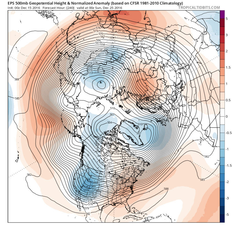
The pattern is still on track to turn milder after we're out of this cold stretch early next week. EPO, AO, and NAO will be positive and the PNA predominately negative. It's not surprising since I thought the 12th to 18th was a transient period of colder than normal weather, but it is frustrating that it's changing over Christmas week. Unfortunately this could last well into January. New JMA seasonal flipped to much above normal temps in January.

_________________
_______________________________________________________________________________________________________
CLICK HERE to view NJ Strong Snowstorm Classifications
 Re: Long Range Thread 12.0
Here's to hoping Jim Witt is right about February. I think tropical forcing or a SSWE could turn us cold again late January or February, but no guarantee.
_________________
_______________________________________________________________________________________________________
CLICK HERE to view NJ Strong Snowstorm Classifications
 Re: Long Range Thread 12.0
This graphic suggests WAF may be on the increase around New Years. If this is true, it may set up a precursor pattern in the Troposphere that leads to a possible SSWE sometime the first half of January. Long way to go, but at least it's cool to see.


_________________
_______________________________________________________________________________________________________
CLICK HERE to view NJ Strong Snowstorm Classifications
 Re: Long Range Thread 12.0
Christmas Day


_________________
_______________________________________________________________________________________________________
CLICK HERE to view NJ Strong Snowstorm Classifications
Page 38 of 40 •  1 ... 20 ... 37, 38, 39, 40
Page 38 of 40
Permissions in this forum:
You cannot reply to topics in this forum
 Home
Home