Long Range Thread 12.0
+30
StatenWx
Dunnzoo
weatherwatchermom
Quietace
dkodgis
mwilli5783
jrollins628
devsman
skinsfan1177
billg315
jmanley32
Snow88
chief7
Dtone
Isotherm
sroc4
docstox12
CPcantmeasuresnow
frank 638
track17
NjWeatherGuy
HectorO
SNOW MAN
rb924119
Math23x7
algae888
snow247
amugs
nutleyblizzard
Frank_Wx
34 posters
Page 39 of 40
Page 39 of 40 •  1 ... 21 ... 38, 39, 40
 Re: Long Range Thread 12.0
This graphic suggests WAF may be on the increase around New Years. If this is true, it may set up a precursor pattern in the Troposphere that leads to a possible SSWE sometime the first half of January. Long way to go, but at least it's cool to see.


 Re: Long Range Thread 12.0
NJ Strong get together at Jenkinson's mid-late December anyone? We can sit outside where it will feel as warm as it did on June 14th, 2015.
Math23x7- Wx Statistician Guru

- Posts : 2382
Reputation : 68
Join date : 2013-01-08
 Re: Long Range Thread 12.0
Well there goes the month of January. Late December and we're already talking about February because Jan could be a complete bust.

HectorO- Pro Enthusiast

- Posts : 977
Reputation : 27
Join date : 2013-01-11
 Re: Long Range Thread 12.0
This needs to come to fruition for us, not buying all the BUST talk for winter, sorry.


Last edited by amugs on Fri Dec 16, 2016 6:18 pm; edited 1 time in total
_________________
Mugs
AKA:King: Snow Weenie
Self Proclaimed
WINTER 2014-15 : 55.12" +.02 for 6 coatings (avg. 35")
WINTER 2015-16 Total - 29.8" (Avg 35")
WINTER 2016-17 : 39.5" so far

amugs- Advanced Forecaster - Mod

- Posts : 15156
Reputation : 213
Join date : 2013-01-07
Age : 54
Location : Hillsdale,NJ
 Re: Long Range Thread 12.0
To be fair, no one here cancelled winter. It's just acknowledging that an unfavorable pattern between Christmas and New Years is likely.
_________________
_______________________________________________________________________________________________________
CLICK HERE to view NJ Strong Snowstorm Classifications
 Re: Long Range Thread 12.0
Mugs did get to ice skate so the winter has not been "that" bad so far. 


dkodgis- Senior Enthusiast

- Posts : 2693
Reputation : 98
Join date : 2013-12-29
 Re: Long Range Thread 12.0
amugs wrote:This needs to come to fruition for us, not buying all the BUST talk for winter, sorry.
With all due respect Mugs this isnt exactly a great look. Maybe more like a less crappy to mediocre at best look. I mean the EPO goes from strong positive to less positive with a trend toward neutral in the LR. Better than the +4 but nothing to write home about. With this he exception of a single run 4-5 runs ago and the most run where it went a smidge below 0 the EPO remains positive here.
All that said I for one am not canceling winter by a long shot. Like Frank said though I don't remember anyone, with the exception of James(sorry paison), calling this winter a bust. However, There is no denying an unfavorable setup on the horizon that looks to last at least a couple of weeks. Beyond that is still speculation.
_________________
"In weather and in life, there's no winning and losing; there's only winning and learning."
WINTER 2012/2013 TOTALS 43.65"WINTER 2017/2018 TOTALS 62.85" WINTER 2022/2023 TOTALS 4.9"
WINTER 2013/2014 TOTALS 64.85"WINTER 2018/2019 TOTALS 14.25" WINTER 2023/2024 TOTALS 13.1"
WINTER 2014/2015 TOTALS 71.20"WINTER 2019/2020 TOTALS 6.35" WINTER 2024/2025 TOTALS 0.00
WINTER 2015/2016 TOTALS 35.00"WINTER 2020/2021 TOTALS 37.75"
WINTER 2016/2017 TOTALS 42.25"WINTER 2021/2022 TOTALS 31.65"

sroc4- Admin

- Posts : 8458
Reputation : 302
Join date : 2013-01-07
Location : Wading River, LI
 Re: Long Range Thread 12.0
Ensembles are hinting that the 23rd to 25th period could produce another snow event for the area, but the interior and New England is favored of course. Hey, as long as the PAC s/w doesn't amplify too much and we can keep the SE Ridge muted, then we have a fighting chance. Beyond that, both suites show the SE Ridge returning as the +EPO/+AO/+NAO/-PNA pattern takes hold.
_________________
_______________________________________________________________________________________________________
CLICK HERE to view NJ Strong Snowstorm Classifications
 Re: Long Range Thread 12.0
Frank_Wx wrote:Ensembles are hinting that the 23rd to 25th period could produce another snow event for the area, but the interior and New England is favored of course. Hey, as long as the PAC s/w doesn't amplify too much and we can keep the SE Ridge muted, then we have a fighting chance. Beyond that, both suites show the SE Ridge returning as the +EPO/+AO/+NAO/-PNA pattern takes hold.
I'm not greedy, just ask for some chilly temps that's all.

HectorO- Pro Enthusiast

- Posts : 977
Reputation : 27
Join date : 2013-01-11
 Re: Long Range Thread 12.0
Yes cmc shows a nice hit for the interior on Thursday. Also there will be plenty of cold air out west Northward through Canada and Alaska so once the pattern flips it will not take very long for us to get below normal imo.Frank_Wx wrote:Ensembles are hinting that the 23rd to 25th period could produce another snow event for the area, but the interior and New England is favored of course. Hey, as long as the PAC s/w doesn't amplify too much and we can keep the SE Ridge muted, then we have a fighting chance. Beyond that, both suites show the SE Ridge returning as the +EPO/+AO/+NAO/-PNA pattern takes hold.

algae888- Advanced Forecaster

- Posts : 5311
Reputation : 46
Join date : 2013-02-05
Age : 62
Location : mt. vernon, new york
 Re: Long Range Thread 12.0
teleconnections all look like crap at least the big three AO + NAO neutral and the PNA- 
chief7- Posts : 132
Reputation : 0
Join date : 2013-11-10
Location : Langhorne pa
 Re: Long Range Thread 12.0
chief7 wrote:teleconnections all look like crap at least the big three AO + NAO neutral and the PNA-
Yup......
_________________
_______________________________________________________________________________________________________
CLICK HERE to view NJ Strong Snowstorm Classifications
 Re: Long Range Thread 12.0
Euro ensambles are trying to build back the Aleutian Ridge Poleward again in the day 11 to 15. Also today's Euro operational has another arctic front coming through Christmas morning looks as cold if not colder than this past arctic outbreak. As long as we can get that ridge to rebuild there will be plenty of cold air close by, so any storm cutting beneath us or even a weak storm cutting to our West has the potential for snow. big difference from last year that we have a cold source.

algae888- Advanced Forecaster

- Posts : 5311
Reputation : 46
Join date : 2013-02-05
Age : 62
Location : mt. vernon, new york
 Re: Long Range Thread 12.0
The Canadian ensembles are similar to the euro with the poleward Aleutian Ridge the GFS is flattered with the same feature. However looks like no help on the Atlantic side. Two things seem certain they'll be plenty of cold air in Northwest Canada which should provide Arctic outbreaks periodically in our area and a very active pattern. It should be a lot of fun this winter tracking all these systems. not all going to to be in our favor but we should do pretty well overall. Get the cold here and the snow will come. Thank God El Nino is gone.

algae888- Advanced Forecaster

- Posts : 5311
Reputation : 46
Join date : 2013-02-05
Age : 62
Location : mt. vernon, new york
 Re: Long Range Thread 12.0
Stratospheric 10hpa temperatures should reach record lows at 90N in the next week, and near record lows at 60-90N around Christmas. The tropospheric regime is reflective of that w/ a +5 standard deviation AO next week. Accumulating snow (of the 3"+ variety) at the coast will be nothing short of a Christmas miracle over the next week to 10 days.
If this year's vortex follows a progression congruous with prior similar historical cases, it will remain potent through all of January, with a weakening trend at the end of the month, followed by potential SSW attempt and/or significant weakening in the first half of February. That would induce tropospheric alterations such that Feb 5/10-end of winter delivers the most NAO / AO domain blocking of the season. This is all "a priori" of course, and we could very well have a strong vortex through March. However, historically, similar cases will yield at least a weakening in February, and thus probably our highest probability of protracted -AO/NAO is Feb/Mar.
If this year's vortex follows a progression congruous with prior similar historical cases, it will remain potent through all of January, with a weakening trend at the end of the month, followed by potential SSW attempt and/or significant weakening in the first half of February. That would induce tropospheric alterations such that Feb 5/10-end of winter delivers the most NAO / AO domain blocking of the season. This is all "a priori" of course, and we could very well have a strong vortex through March. However, historically, similar cases will yield at least a weakening in February, and thus probably our highest probability of protracted -AO/NAO is Feb/Mar.
 Re: Long Range Thread 12.0
sroc4 wrote:amugs wrote:This needs to come to fruition for us, not buying all the BUST talk for winter, sorry.
With all due respect Mugs this isnt exactly a great look. Maybe more like a less crappy to mediocre at best look. I mean the EPO goes from strong positive to less positive with a trend toward neutral in the LR. Better than the +4 but nothing to write home about. With this he exception of a single run 4-5 runs ago and the most run where it went a smidge below 0 the EPO remains positive here.
All that said I for one am not canceling winter by a long shot. Like Frank said though I don't remember anyone, with the exception of James(sorry paison), calling this winter a bust. However, There is no denying an unfavorable setup on the horizon that looks to last at least a couple of weeks. Beyond that is still speculation.
Agree Scott. I went warmer than normal for both Jan/Feb in my outlook, but I think our best opportunity for a NAO/AO protracted shake-up/reversal might be February (ironically, the month everyone largely agreed for warmer than normal). I'm still sticking with warmer than normal, but if there is a -AO/NAO month, February has the best chance. +5 AO's near Christmas tend to strongly correlate to the January state, so I'd be willing to bet January finishes +NAO/AO on the mean.
Still, I think we'll get some windows in Jan with occasional poleward ridging.
 Re: Long Range Thread 12.0
Isotherm wrote:sroc4 wrote:amugs wrote:This needs to come to fruition for us, not buying all the BUST talk for winter, sorry.
With all due respect Mugs this isnt exactly a great look. Maybe more like a less crappy to mediocre at best look. I mean the EPO goes from strong positive to less positive with a trend toward neutral in the LR. Better than the +4 but nothing to write home about. With this he exception of a single run 4-5 runs ago and the most run where it went a smidge below 0 the EPO remains positive here.
All that said I for one am not canceling winter by a long shot. Like Frank said though I don't remember anyone, with the exception of James(sorry paison), calling this winter a bust. However, There is no denying an unfavorable setup on the horizon that looks to last at least a couple of weeks. Beyond that is still speculation.
Agree Scott. I went warmer than normal for both Jan/Feb in my outlook, but I think our best opportunity for a NAO/AO protracted shake-up/reversal might be February (ironically, the month everyone largely agreed for warmer than normal). I'm still sticking with warmer than normal, but if there is a -AO/NAO month, February has the best chance. +5 AO's near Christmas tend to strongly correlate to the January state, so I'd be willing to bet January finishes +NAO/AO on the mean.
Still, I think we'll get some windows in Jan with occasional poleward ridging.
I wish you didnt Tom
_________________
"In weather and in life, there's no winning and losing; there's only winning and learning."
WINTER 2012/2013 TOTALS 43.65"WINTER 2017/2018 TOTALS 62.85" WINTER 2022/2023 TOTALS 4.9"
WINTER 2013/2014 TOTALS 64.85"WINTER 2018/2019 TOTALS 14.25" WINTER 2023/2024 TOTALS 13.1"
WINTER 2014/2015 TOTALS 71.20"WINTER 2019/2020 TOTALS 6.35" WINTER 2024/2025 TOTALS 0.00
WINTER 2015/2016 TOTALS 35.00"WINTER 2020/2021 TOTALS 37.75"
WINTER 2016/2017 TOTALS 42.25"WINTER 2021/2022 TOTALS 31.65"

sroc4- Admin

- Posts : 8458
Reputation : 302
Join date : 2013-01-07
Location : Wading River, LI
 Re: Long Range Thread 12.0
Frank_Wx wrote:Ensembles are hinting that the 23rd to 25th period could produce another snow event for the area, but the interior and New England is favored of course. Hey, as long as the PAC s/w doesn't amplify too much and we can keep the SE Ridge muted, then we have a fighting chance. Beyond that, both suites show the SE Ridge returning as the +EPO/+AO/+NAO/-PNA pattern takes hold.
Been interested in this period for a while. I think Al or mugsy was speaking about it with me earlier in the week.....haven't paid much attention since this little storm, though haha time to get back into it :p
rb924119- Meteorologist

- Posts : 7112
Reputation : 195
Join date : 2013-02-06
Age : 32
Location : Greentown, Pa
 Re: Long Range Thread 12.0
algae888 wrote:The Canadian ensembles are similar to the euro with the poleward Aleutian Ridge the GFS is flattered with the same feature. However looks like no help on the Atlantic side. Two things seem certain they'll be plenty of cold air in Northwest Canada which should provide Arctic outbreaks periodically in our area and a very active pattern. It should be a lot of fun this winter tracking all these systems. not all going to to be in our favor but we should do pretty well overall. Get the cold here and the snow will come. Thank God El Nino is gone.
Amen to that!!!!!!

CPcantmeasuresnow- Wx Statistician Guru

- Posts : 7288
Reputation : 230
Join date : 2013-01-07
Age : 103
Location : Eastern Orange County, NY
 Re: Long Range Thread 12.0
When the cold.front come sthrough here between the jan 4 -6 timefrane. Mercury passes by earth when this happens we have a strong cold front just like tomorrow night/monday. Long-lasting not sure but it is a start.
Also, late Jan through late Feb as per Jim Witt and his terrestrial forecasting with analogs back to 1876 shows Uranus ( no jokes please) is in sextant, 60 degrees with earth's perigee we go in the freezer in the CONUS.
The 23 -25th time frame is interesting to me even though we don't have the tees for one but Big Momma?
Reading from another poster that is a pro forecaster he sees the MJO going into phase 7,8,1 even though the tees aren't showing it now. He was sharing the Chi charts on this and it is interesting.
Xmass week looks to be Meh no denying it. Time will tell with this as well. As Al stated abundance of polar air sitting just up to our north to tap with agreat snowpack, glacier to our North and west.
_________________
Mugs
AKA:King: Snow Weenie
Self Proclaimed
WINTER 2014-15 : 55.12" +.02 for 6 coatings (avg. 35")
WINTER 2015-16 Total - 29.8" (Avg 35")
WINTER 2016-17 : 39.5" so far

amugs- Advanced Forecaster - Mod

- Posts : 15156
Reputation : 213
Join date : 2013-01-07
Age : 54
Location : Hillsdale,NJ
 Re: Long Range Thread 12.0
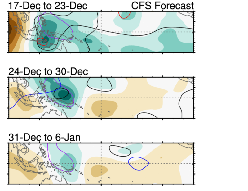
I'm not sure I can hop onto the tropical forcing / MJO train just yet. I acknowledge the convective wave that will move out of the Indian Ocean and into the west Equatorial Pacific, but where will this ridge set-up in the northern Pacific?
Here is a look at 200 CHI over the next 3 weeks. Subsidence will remain over the Dateline while 120E will experience enhanced precipitation from this tropical wave. This is normally indicative of an MJO in phase 6.
According to the La Nina reanalysis 500mb graphics, an MJO in phase 6 produces a +PNA/-WPO - enough to drive cold air into the east.

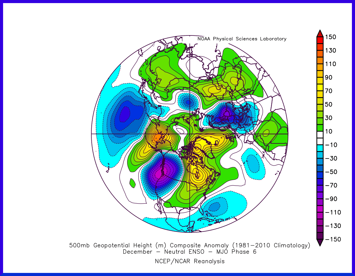
However, the 500mb pattern Ensembles are suggesting will happen looks more like an phase 6 MJO with neutral ENSO conditions. Here is the 500mb reanalysis depiction in that scenario.
Then here is your EPS for late December...
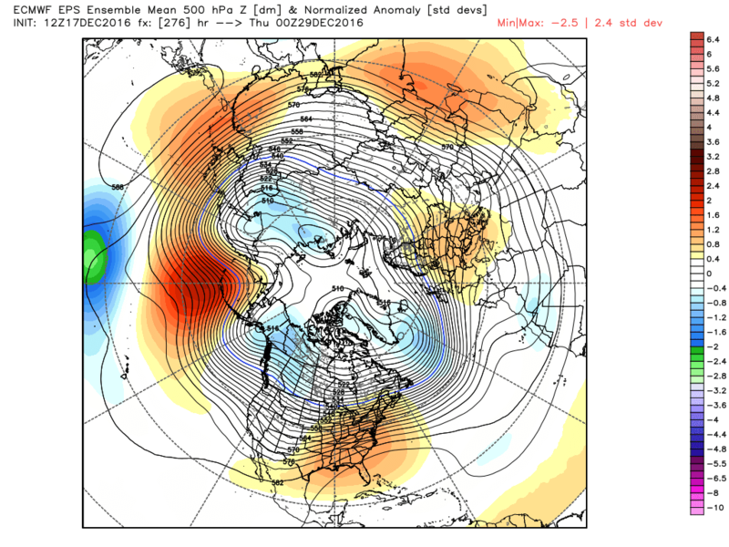
The Pacific pattern between the two graphics is strikingly similar, but they're way off on the Atlantic side and that could be because of how poor Stratospheric conditions are at the moment.
So, if that's the pattern we're headed toward then consider me cautiously optimistic. Certainly I am not enthused. For the most part, the -PNA will keep the SE ridge in play. And with the NAO/AO the way they're forecasted to be, it's likely not great news for us.
The positive is ridging will return to the WPO region but keep in mind when this happened 10 days ago, the ridge cut off in the western Arctic and displaced arctic air into the CONUS. Models are not showing that at the moment, just a ridge placed too far west that would keep the EPO neutral and the PNA negative. Now, can some of these higher heights enter the EPO region and drive colder air into the eastern CONUS? Absolutely. I would not discount it. I would just place the odds low until we see evidence of it happening.
All in all, I feel the period after Christmas is an unfavorable pattern that will take time to erode. Something much more stronger than a tropical wave entering MJO phase 6 territory. This is where La Nina forcing could have actually played a key role. Wildcard is the Stratosphere. We'll see where it takes us come January.
Here is a look at 200 CHI over the next 3 weeks. Subsidence will remain over the Dateline while 120E will experience enhanced precipitation from this tropical wave. This is normally indicative of an MJO in phase 6.

According to the La Nina reanalysis 500mb graphics, an MJO in phase 6 produces a +PNA/-WPO - enough to drive cold air into the east.

However, the 500mb pattern Ensembles are suggesting will happen looks more like an phase 6 MJO with neutral ENSO conditions. Here is the 500mb reanalysis depiction in that scenario.

Then here is your EPS for late December...

The Pacific pattern between the two graphics is strikingly similar, but they're way off on the Atlantic side and that could be because of how poor Stratospheric conditions are at the moment.
So, if that's the pattern we're headed toward then consider me cautiously optimistic. Certainly I am not enthused. For the most part, the -PNA will keep the SE ridge in play. And with the NAO/AO the way they're forecasted to be, it's likely not great news for us.
The positive is ridging will return to the WPO region but keep in mind when this happened 10 days ago, the ridge cut off in the western Arctic and displaced arctic air into the CONUS. Models are not showing that at the moment, just a ridge placed too far west that would keep the EPO neutral and the PNA negative. Now, can some of these higher heights enter the EPO region and drive colder air into the eastern CONUS? Absolutely. I would not discount it. I would just place the odds low until we see evidence of it happening.
All in all, I feel the period after Christmas is an unfavorable pattern that will take time to erode. Something much more stronger than a tropical wave entering MJO phase 6 territory. This is where La Nina forcing could have actually played a key role. Wildcard is the Stratosphere. We'll see where it takes us come January.
_________________
_______________________________________________________________________________________________________
CLICK HERE to view NJ Strong Snowstorm Classifications
 Re: Long Range Thread 12.0
Gfs saying warm and Euro saying what u talkin about Willis??
FIGHT FIGHT FIGHT!!
ALSO 23RD AND XMASS time frame thread the needle but we shall see GFS showing g the possibility of more white gold and then fall like
Here are the maps from Venice on the warmth vs colder look

FIGHT FIGHT FIGHT!!
ALSO 23RD AND XMASS time frame thread the needle but we shall see GFS showing g the possibility of more white gold and then fall like
Here are the maps from Venice on the warmth vs colder look

_________________
Mugs
AKA:King: Snow Weenie
Self Proclaimed
WINTER 2014-15 : 55.12" +.02 for 6 coatings (avg. 35")
WINTER 2015-16 Total - 29.8" (Avg 35")
WINTER 2016-17 : 39.5" so far

amugs- Advanced Forecaster - Mod

- Posts : 15156
Reputation : 213
Join date : 2013-01-07
Age : 54
Location : Hillsdale,NJ
 Re: Long Range Thread 12.0
Frank_Wx wrote:I'm not sure I can hop onto the tropical forcing / MJO train just yet. I acknowledge the convective wave that will move out of the Indian Ocean and into the west Equatorial Pacific, but where will this ridge set-up in the northern Pacific?
Here is a look at 200 CHI over the next 3 weeks. Subsidence will remain over the Dateline while 120E will experience enhanced precipitation from this tropical wave. This is normally indicative of an MJO in phase 6.
According to the La Nina reanalysis 500mb graphics, an MJO in phase 6 produces a +PNA/-WPO - enough to drive cold air into the east.
However, the 500mb pattern Ensembles are suggesting will happen looks more like an phase 6 MJO with neutral ENSO conditions. Here is the 500mb reanalysis depiction in that scenario.
Then here is your EPS for late December...
The Pacific pattern between the two graphics is strikingly similar, but they're way off on the Atlantic side and that could be because of how poor Stratospheric conditions are at the moment.
So, if that's the pattern we're headed toward then consider me cautiously optimistic. Certainly I am not enthused. For the most part, the -PNA will keep the SE ridge in play. And with the NAO/AO the way they're forecasted to be, it's likely not great news for us.
The positive is ridging will return to the WPO region but keep in mind when this happened 10 days ago, the ridge cut off in the western Arctic and displaced arctic air into the CONUS. Models are not showing that at the moment, just a ridge placed too far west that would keep the EPO neutral and the PNA negative. Now, can some of these higher heights enter the EPO region and drive colder air into the eastern CONUS? Absolutely. I would not discount it. I would just place the odds low until we see evidence of it happening.
All in all, I feel the period after Christmas is an unfavorable pattern that will take time to erode. Something much more stronger than a tropical wave entering MJO phase 6 territory. This is where La Nina forcing could have actually played a key role. Wildcard is the Stratosphere. We'll see where it takes us come January.
Great Post
_________________
"In weather and in life, there's no winning and losing; there's only winning and learning."
WINTER 2012/2013 TOTALS 43.65"WINTER 2017/2018 TOTALS 62.85" WINTER 2022/2023 TOTALS 4.9"
WINTER 2013/2014 TOTALS 64.85"WINTER 2018/2019 TOTALS 14.25" WINTER 2023/2024 TOTALS 13.1"
WINTER 2014/2015 TOTALS 71.20"WINTER 2019/2020 TOTALS 6.35" WINTER 2024/2025 TOTALS 0.00
WINTER 2015/2016 TOTALS 35.00"WINTER 2020/2021 TOTALS 37.75"
WINTER 2016/2017 TOTALS 42.25"WINTER 2021/2022 TOTALS 31.65"

sroc4- Admin

- Posts : 8458
Reputation : 302
Join date : 2013-01-07
Location : Wading River, LI
 Re: Long Range Thread 12.0
Seems to be a lit of uncertainty about the warm up

skinsfan1177- Senior Enthusiast

- Posts : 4485
Reputation : 35
Join date : 2013-01-07
Age : 47
Location : Point Pleasant Boro
 Re: Long Range Thread 12.0
skinsfan1177 wrote:Seems to be a lit of uncertainty about the warm up
Yeah Skins. I noticing a few things in the LR that at first glance look really warm for the east but if you look a little deeper I can see how things aren't quite as bad as they may seem. I may try and do a write up on it tomorrow if someone else doesn't point it out first. Particularly the ridging S of the Aleutians and the Ridging over Scananavia and N Europe and their potential partnership beyond day 10. There are a few diff between the GEFS and EPS as one would expect, but both show a decent signal. IF these two ridges trend stronger poleward as we go on in time they may teleconnect with each other leading to another displacement of arctic air into the mid latitudes. As per usual, however, models may be too quick in doing this. Again I will try and do a write up with some details on this with maps to make this more clear.
_________________
"In weather and in life, there's no winning and losing; there's only winning and learning."
WINTER 2012/2013 TOTALS 43.65"WINTER 2017/2018 TOTALS 62.85" WINTER 2022/2023 TOTALS 4.9"
WINTER 2013/2014 TOTALS 64.85"WINTER 2018/2019 TOTALS 14.25" WINTER 2023/2024 TOTALS 13.1"
WINTER 2014/2015 TOTALS 71.20"WINTER 2019/2020 TOTALS 6.35" WINTER 2024/2025 TOTALS 0.00
WINTER 2015/2016 TOTALS 35.00"WINTER 2020/2021 TOTALS 37.75"
WINTER 2016/2017 TOTALS 42.25"WINTER 2021/2022 TOTALS 31.65"

sroc4- Admin

- Posts : 8458
Reputation : 302
Join date : 2013-01-07
Location : Wading River, LI
 Re: Long Range Thread 12.0
sroc4 wrote:skinsfan1177 wrote:Seems to be a lit of uncertainty about the warm up
Yeah Skins. I noticing a few things in the LR that at first glance look really warm for the east but if you look a little deeper I can see how things aren't quite as bad as they may seem. I may try and do a write up on it tomorrow if someone else doesn't point it out first. Particularly the ridging S of the Aleutians and the Ridging over Scananavia and N Europe and their potential partnership beyond day 10. There are a few diff between the GEFS and EPS as one would expect, but both show a decent signal. IF these two ridges trend stronger poleward as we go on in time they may teleconnect with each other leading to another displacement of arctic air into the mid latitudes. As per usual, however, models may be too quick in doing this. Again I will try and do a write up with some details on this with maps to make this more clear.
I think I am also going to add to this discussion, maybe later today with a quick video. The progged pattern, mainly as we head close to the New Year and beyond, does not actually scream "warmth" to me for our region.
rb924119- Meteorologist

- Posts : 7112
Reputation : 195
Join date : 2013-02-06
Age : 32
Location : Greentown, Pa
Page 39 of 40 •  1 ... 21 ... 38, 39, 40
Page 39 of 40
Permissions in this forum:
You cannot reply to topics in this forum
 Home
Home
