Fundamental Pattern Change on the Wind:
+4
algae888
Dunnzoo
rb924119
sroc4
8 posters
 Fundamental Pattern Change on the Wind:
Its been awhile since I have had a post with any real substance to it. So I wanted to discuss the potential upcoming pattern change. In order to see where we are going I first want to discuss where we currently stand.
We will begin with some definitions. Walker Circulation: Loosely defined is the large scale pattern of rising and sinking air along the equator. The ENSO status (El Nino, La Nina or La Nada AKA the SST anomalies in the Tropical Pac typically drives the Walker Circulation.
Refer to this Link for a detailed discussion on the Walker Circulation and is the area I am pulling the following maps from. https://www.climate.gov/news-features/blogs/enso/walker-circulation-ensos-atmospheric-buddy
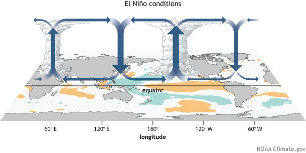
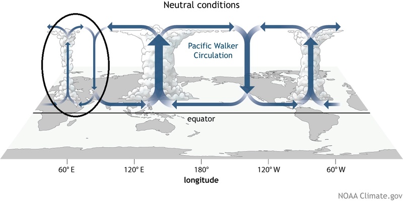
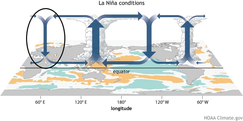
There are typical Walker circulation generalities with respect to the status of ENSO. See the maps below.
The next map is what we call an OLR map. OLR stands for outgoing Longwave Radiation. I know fancy. Basically on this map where you see the colder colors in blues or purples indicates upward motion or rising air or where we have convection. The warmer colors is where we have sinking air and therefore a lack of convection.

Now refer back to the images above defining the general walker circulation for a specific ENSO status. Notice how since the beginning of September the Walker circulation is behaving typical of La Nina as seen by sinking air around 60E, rising air around 120E, neutral to sinking air between 180-120W, and weak but rising air near 60W. This correlates nicely with the SST anomalies throughout the Trop Pac as well as the SOI throughout the month of Sept which if you recall was persistently strongly positive which correlates with a La Nina. That said most of October the SOI has been neutral to negative with the past 3days a strongly negative SOI burst is occurring. This in the words of JB typically acts as a "cattle prod" to the atmosphere that may drive the pattern change going foward. We will have to see if there is a change to the SST anomalies following October back towards a Neutral ENSO state, as well as a neutral Walker circulation. There is typically a lag between atmospheric changes and SST changes.
https://www.longpaddock.qld.gov.au/seasonalclimateoutlook/southernoscillationindex/30daysoivalues/
The full thickness stratospheric split that is occurring as we speak; however, could be the main driver behind it all. That said typically there is a lag of at least 7-14days if im not mistaken behind the strat changes and the tropospheric response.
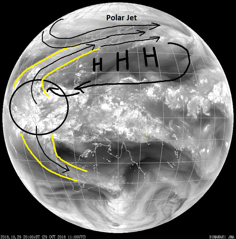
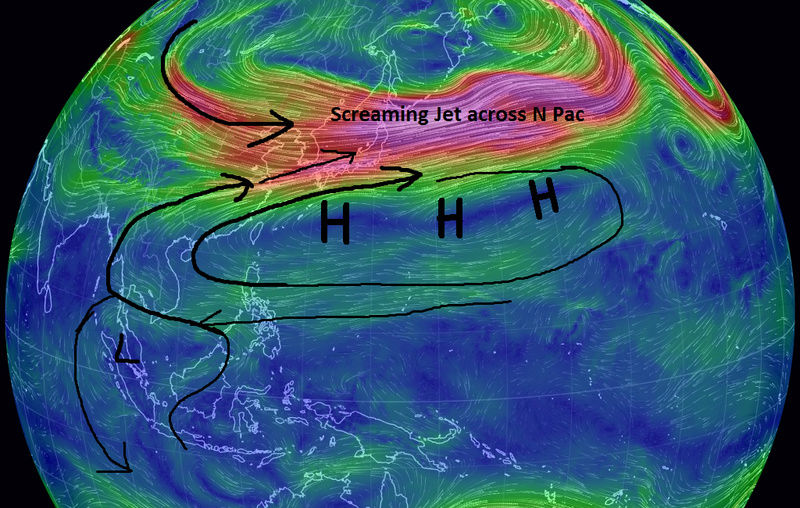
Lets now look at actual Satellite observational data and tie it in with the images above. The next image is the current full disk water vapor image of the Pac. I have outlined several key features. The yellow lines are showing clearly that the convection around 120E has led to an "atmospheric river" (relatively narrow regions in the atmosphere that are responsible for most of the horizontal transport of water vapor outside of the tropics). Put another way the energy generated from the rising motion in Equatorial Pac around 120E (refer to OLR map above)is being transferred North and is enhancing the strength of the Polar Jet stream across the northern Pac.
Here is the loop which shows the outlined features above nicely. Notice it is doing the same thing in the southern hemisphere as well.
http://www.goes.noaa.gov/dml/jma/fd/wvblue.html
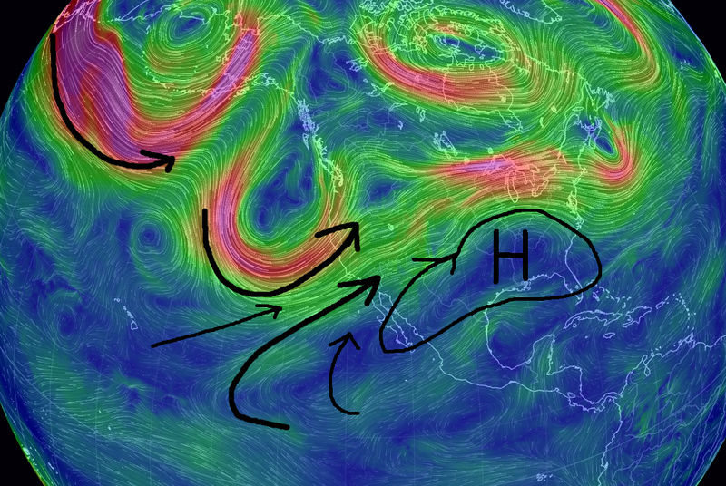
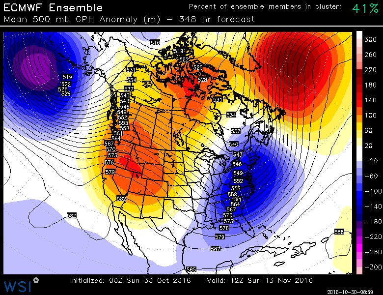
Lets look at the last two images above from the perspective of last nights Euro Ensembles (EPS) at initialization. Notice the position of the trough off the west coast leads to the position of the Ridge in the center of the CONUS keeping the warm temp anomalies to our west while we have a transient trough in the NE. That trough sitting off the NW Coast MUST leave for the fundamental pattern change to occur because it leads to a warm source region that floods the nation with Pac air.

By mid week; however, notice the trough that was off the west coast is now shifted SE; centered in the SE CONUS. This in turn shifts the ridge to the EC. Most of this upcoming week will be above normal with a strong SW flow due to this. But things are changing. Take notice at the negative (blue color) showing up in the top left corner of the image below. This is the area S of Japan. Up until now there has been a large broad ridge in the Central Pac, the western flank of which has extended into SE Asia, and a large broad trough to the N with the strong N Pac Polar jet separating the two(see images above).
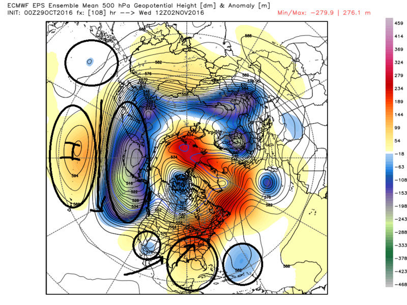
Currently the Walker Circulation is La Nina like with the main area of convection focused around 120E; however, if this negative showing up into SE Asia is real it should in theory lead to a shift in the main focus of the convection in the Pacific east towards the dateline. This fundamentally will change the Polar jet stream pattern. We should in theory begin to see the "atmospheric river" shift towards enhancing the newly established sharper and more focused than broad trough, like it is now, south of the Aleutian Islands. This is key because a sharper trough S of the Aleutian Islands pumps the PNA ridge and or EPO ridge along the west coast of the USA and Canada which in turn deepens the trough in the east, fundamentally changing the source region for our sensible weather in the east.

Where exactly, or how close to the west coast the Trough is centered, will dictate where the ridge axis and consequently east coast trough axis is centered which ultimately affects storm track, phasing possibilites etc. I expect, as is usually the case, the Long range modeling of this pattern change will occur later in reality then what is currently being modeled, but I do believe it is coming. IF the pattern shifts in the way I describe above it would def lead to a pattern that could lead to winter storm potential come mid-late Nov into December and maybe even a surprise in the first 7-10 days of Nov. I'm going to try and take snap shots of the Satellite images along the way to monitor the shifts in some of the key features outlined above and retrospectively be able to compare to what the models currently show in the Long Range. Although I am using the EPS the GEFS are similar in most of the evolution of the features I've described above. I really look forward to Franks Winter outlook which if you haven't noticed is only two days away! Interesting times ahead.
WE TRACK!!
We will begin with some definitions. Walker Circulation: Loosely defined is the large scale pattern of rising and sinking air along the equator. The ENSO status (El Nino, La Nina or La Nada AKA the SST anomalies in the Tropical Pac typically drives the Walker Circulation.
Refer to this Link for a detailed discussion on the Walker Circulation and is the area I am pulling the following maps from. https://www.climate.gov/news-features/blogs/enso/walker-circulation-ensos-atmospheric-buddy
There are typical Walker circulation generalities with respect to the status of ENSO. See the maps below.


The next map is what we call an OLR map. OLR stands for outgoing Longwave Radiation. I know fancy. Basically on this map where you see the colder colors in blues or purples indicates upward motion or rising air or where we have convection. The warmer colors is where we have sinking air and therefore a lack of convection.

Now refer back to the images above defining the general walker circulation for a specific ENSO status. Notice how since the beginning of September the Walker circulation is behaving typical of La Nina as seen by sinking air around 60E, rising air around 120E, neutral to sinking air between 180-120W, and weak but rising air near 60W. This correlates nicely with the SST anomalies throughout the Trop Pac as well as the SOI throughout the month of Sept which if you recall was persistently strongly positive which correlates with a La Nina. That said most of October the SOI has been neutral to negative with the past 3days a strongly negative SOI burst is occurring. This in the words of JB typically acts as a "cattle prod" to the atmosphere that may drive the pattern change going foward. We will have to see if there is a change to the SST anomalies following October back towards a Neutral ENSO state, as well as a neutral Walker circulation. There is typically a lag between atmospheric changes and SST changes.
https://www.longpaddock.qld.gov.au/seasonalclimateoutlook/southernoscillationindex/30daysoivalues/
The full thickness stratospheric split that is occurring as we speak; however, could be the main driver behind it all. That said typically there is a lag of at least 7-14days if im not mistaken behind the strat changes and the tropospheric response.
Lets now look at actual Satellite observational data and tie it in with the images above. The next image is the current full disk water vapor image of the Pac. I have outlined several key features. The yellow lines are showing clearly that the convection around 120E has led to an "atmospheric river" (relatively narrow regions in the atmosphere that are responsible for most of the horizontal transport of water vapor outside of the tropics). Put another way the energy generated from the rising motion in Equatorial Pac around 120E (refer to OLR map above)is being transferred North and is enhancing the strength of the Polar Jet stream across the northern Pac.

Here is the loop which shows the outlined features above nicely. Notice it is doing the same thing in the southern hemisphere as well.
http://www.goes.noaa.gov/dml/jma/fd/wvblue.html


Lets look at the last two images above from the perspective of last nights Euro Ensembles (EPS) at initialization. Notice the position of the trough off the west coast leads to the position of the Ridge in the center of the CONUS keeping the warm temp anomalies to our west while we have a transient trough in the NE. That trough sitting off the NW Coast MUST leave for the fundamental pattern change to occur because it leads to a warm source region that floods the nation with Pac air.

By mid week; however, notice the trough that was off the west coast is now shifted SE; centered in the SE CONUS. This in turn shifts the ridge to the EC. Most of this upcoming week will be above normal with a strong SW flow due to this. But things are changing. Take notice at the negative (blue color) showing up in the top left corner of the image below. This is the area S of Japan. Up until now there has been a large broad ridge in the Central Pac, the western flank of which has extended into SE Asia, and a large broad trough to the N with the strong N Pac Polar jet separating the two(see images above).

Currently the Walker Circulation is La Nina like with the main area of convection focused around 120E; however, if this negative showing up into SE Asia is real it should in theory lead to a shift in the main focus of the convection in the Pacific east towards the dateline. This fundamentally will change the Polar jet stream pattern. We should in theory begin to see the "atmospheric river" shift towards enhancing the newly established sharper and more focused than broad trough, like it is now, south of the Aleutian Islands. This is key because a sharper trough S of the Aleutian Islands pumps the PNA ridge and or EPO ridge along the west coast of the USA and Canada which in turn deepens the trough in the east, fundamentally changing the source region for our sensible weather in the east.

Where exactly, or how close to the west coast the Trough is centered, will dictate where the ridge axis and consequently east coast trough axis is centered which ultimately affects storm track, phasing possibilites etc. I expect, as is usually the case, the Long range modeling of this pattern change will occur later in reality then what is currently being modeled, but I do believe it is coming. IF the pattern shifts in the way I describe above it would def lead to a pattern that could lead to winter storm potential come mid-late Nov into December and maybe even a surprise in the first 7-10 days of Nov. I'm going to try and take snap shots of the Satellite images along the way to monitor the shifts in some of the key features outlined above and retrospectively be able to compare to what the models currently show in the Long Range. Although I am using the EPS the GEFS are similar in most of the evolution of the features I've described above. I really look forward to Franks Winter outlook which if you haven't noticed is only two days away! Interesting times ahead.
WE TRACK!!

Last edited by sroc4 on Sat Oct 29, 2016 10:36 am; edited 2 times in total
_________________
"In weather and in life, there's no winning and losing; there's only winning and learning."
WINTER 2012/2013 TOTALS 43.65"WINTER 2017/2018 TOTALS 62.85" WINTER 2022/2023 TOTALS 4.9"
WINTER 2013/2014 TOTALS 64.85"WINTER 2018/2019 TOTALS 14.25" WINTER 2023/2024 TOTALS 13.1"
WINTER 2014/2015 TOTALS 71.20"WINTER 2019/2020 TOTALS 6.35" WINTER 2024/2025 TOTALS 0.00
WINTER 2015/2016 TOTALS 35.00"WINTER 2020/2021 TOTALS 37.75"
WINTER 2016/2017 TOTALS 42.25"WINTER 2021/2022 TOTALS 31.65"

sroc4- Admin

- Posts : 8458
Reputation : 302
Join date : 2013-01-07
Location : Wading River, LI
 Re: Fundamental Pattern Change on the Wind:
FIRST AL BEAT ME TO IT NOW YOU!!!!! UGHHHH!!! Hahaha nah jk man, GREAT write up and I fully agree!! I just finished a video outlining my thoughts on the same thing, although I took a different route. Will be posted shortly, but it's nice to know that many of us are coming to the same conclusion via entirely separate analyses!!
rb924119- Meteorologist

- Posts : 7112
Reputation : 195
Join date : 2013-02-06
Age : 32
Location : Greentown, Pa
 Re: Fundamental Pattern Change on the Wind:
rb924119 wrote:FIRST AL BEAT ME TO IT NOW YOU!!!!! UGHHHH!!! Hahaha nah jk man, GREAT write up and I fully agree!! I just finished a video outlining my thoughts on the same thing, although I took a different route. Will be posted shortly, but it's nice to know that many of us are coming to the same conclusion via entirely separate analyses!!
Def post it in here Ray I am excited to see it. I'm sure your conclusions are much more meteorologically sound than mine. LOL
_________________
"In weather and in life, there's no winning and losing; there's only winning and learning."
WINTER 2012/2013 TOTALS 43.65"WINTER 2017/2018 TOTALS 62.85" WINTER 2022/2023 TOTALS 4.9"
WINTER 2013/2014 TOTALS 64.85"WINTER 2018/2019 TOTALS 14.25" WINTER 2023/2024 TOTALS 13.1"
WINTER 2014/2015 TOTALS 71.20"WINTER 2019/2020 TOTALS 6.35" WINTER 2024/2025 TOTALS 0.00
WINTER 2015/2016 TOTALS 35.00"WINTER 2020/2021 TOTALS 37.75"
WINTER 2016/2017 TOTALS 42.25"WINTER 2021/2022 TOTALS 31.65"

sroc4- Admin

- Posts : 8458
Reputation : 302
Join date : 2013-01-07
Location : Wading River, LI
 Re: Fundamental Pattern Change on the Wind:
Great write-up Scott, liking where this is going!
_________________
Janet
Snowfall winter of 2023-2024 17.5"
Snowfall winter of 2022-2023 6.0"
Snowfall winter of 2021-2022 17.6" 1" sleet 2/25/22
Snowfall winter of 2020-2021 51.1"
Snowfall winter of 2019-2020 8.5"
Snowfall winter of 2018-2019 25.1"
Snowfall winter of 2017-2018 51.9"
Snowfall winter of 2016-2017 45.6"
Snowfall winter of 2015-2016 29.5"
Snowfall winter of 2014-2015 50.55"
Snowfall winter of 2013-2014 66.5"
Dunnzoo- Senior Enthusiast - Mod

- Posts : 4938
Reputation : 68
Join date : 2013-01-11
Age : 62
Location : Westwood, NJ
 Re: Fundamental Pattern Change on the Wind:
sroc4 wrote:rb924119 wrote:FIRST AL BEAT ME TO IT NOW YOU!!!!! UGHHHH!!! Hahaha nah jk man, GREAT write up and I fully agree!! I just finished a video outlining my thoughts on the same thing, although I took a different route. Will be posted shortly, but it's nice to know that many of us are coming to the same conclusion via entirely separate analyses!!
Def post it in here Ray I am excited to see it. I'm sure your conclusions are much more meteorologically sound than mine. LOL
Wilco!! And they will actually work very much in tandem for reasons you'll soon see
rb924119- Meteorologist

- Posts : 7112
Reputation : 195
Join date : 2013-02-06
Age : 32
Location : Greentown, Pa
 Re: Fundamental Pattern Change on the Wind:
So, the link below is a video that I did this morning highlighting my thoughts on the same topic that Scott just did this write up for. I've said this already, but I'll say it again; having multiple people come to the same conclusion with purely independent methods is rewarding for everybody, not only because there is some safety in consensus, but also because through combination the full picture is revealed. Therefore, I urge everybody to remember Scott's post above and then relate it to my video, because the processes involved are very much linked. For example, the convection and SST changes he mentions coming into the western Pacific, are the same mechanisms that are going to change the wind direction and stem La Nina, as I talked about with SOI.
If I misspoke about anything, since I do not know too much about the Stratosphere; I'm still learning, please correct me. I know there are some on here, Frank and Isotherm are a couple, who know much more about it than I do, so if I can't answer something or if I messed up, hopefully they can lend some assistance. It's a longer video, and I'm sorry haha But there isn't much wasted time, I can promise you that lmao So please enjoy, and you all know the drill!!!
https://drive.google.com/open?id=0Byod2Sk27yNYV21GNHhNSFA1akk
rb924119- Meteorologist

- Posts : 7112
Reputation : 195
Join date : 2013-02-06
Age : 32
Location : Greentown, Pa
 Re: Fundamental Pattern Change on the Wind:
rb924119 wrote:So, the link below is a video that I did this morning highlighting my thoughts on the same topic that Scott just did this write up for. I've said this already, but I'll say it again; having multiple people come to the same conclusion with purely independent methods is rewarding for everybody, not only because there is some safety in consensus, but also because through combination the full picture is revealed. Therefore, I urge everybody to remember Scott's post above and then relate it to my video, because the processes involved are very much linked. For example, the convection and SST changes he mentions coming into the western Pacific, are the same mechanisms that are going to change the wind direction and stem La Nina, as I talked about with SOI.
If I misspoke about anything, since I do not know too much about the Stratosphere; I'm still learning, please correct me. I know there are some on here, Frank and Isotherm are a couple, who know much more about it than I do, so if I can't answer something or if I messed up, hopefully they can lend some assistance. It's a longer video, and I'm sorry haha But there isn't much wasted time, I can promise you that lmao So please enjoy, and you all know the drill!!!
https://drive.google.com/open?id=0Byod2Sk27yNYV21GNHhNSFA1akk
Holy crap Ray!! You are not kidding at all. The combination of both of our discussions really did complimented each other brilliantly.
The full thickness stratospheric split that is occurring as we speak; however, could be the main driver behind it all. That said typically there is a lag of at least 7-14days if im not mistaken behind the strat changes and the tropospheric response.
First off I didn't have time to touch on how this part was involved. And second I would not have been able to articulate it as well as you did. I def learned a ton from your video. Thanks! And the discussion from both of us regarding the SOI was the glue linking the two discussions together. Great stuff!
_________________
"In weather and in life, there's no winning and losing; there's only winning and learning."
WINTER 2012/2013 TOTALS 43.65"WINTER 2017/2018 TOTALS 62.85" WINTER 2022/2023 TOTALS 4.9"
WINTER 2013/2014 TOTALS 64.85"WINTER 2018/2019 TOTALS 14.25" WINTER 2023/2024 TOTALS 13.1"
WINTER 2014/2015 TOTALS 71.20"WINTER 2019/2020 TOTALS 6.35" WINTER 2024/2025 TOTALS 0.00
WINTER 2015/2016 TOTALS 35.00"WINTER 2020/2021 TOTALS 37.75"
WINTER 2016/2017 TOTALS 42.25"WINTER 2021/2022 TOTALS 31.65"

sroc4- Admin

- Posts : 8458
Reputation : 302
Join date : 2013-01-07
Location : Wading River, LI
 Re: Fundamental Pattern Change on the Wind:
Scott and ray normal temperatures are still in the fifties through mid-month so we're going to have to see well below normal temps to have any chance for a winter storm. Looking at ensemble guidance, even though the pattern is favorable, have the core of the cold air over Asia through the 15th of the month with only normal temperatures here. My question is when or--if will we see the cold air over Asia bleed into the Northeast . Climo is really against us at this point. My thinking is more towards the end of the month into early December if the same pattern holds.

algae888- Advanced Forecaster

- Posts : 5311
Reputation : 46
Join date : 2013-02-05
Age : 62
Location : mt. vernon, new york
 Re: Fundamental Pattern Change on the Wind:
Al, you're certainly correct with the norms still being warm, relatively speaking. However, take a look at what just happened with this event, there was no support for cold through the column in our area and parts of the HV and northwestern Connecticut saw upwards of three inches of snow.....from a system that a) cut well to our northwest and b) had no pattern support. The cold air was significantly under modeled, even now it was a few days ago. I think the the same thing is happening with the guidance; it's just not picking up on how cold it's actually going to be. A second way to look at it is to look at the evolution of the temperature forecasts of the ensembles; the past several days they have trended colder, and colder, and colder, and I think that will continue as we get closer and the models start to pick up on the significance of the changes aloft and then link them at the lower levels.
rb924119- Meteorologist

- Posts : 7112
Reputation : 195
Join date : 2013-02-06
Age : 32
Location : Greentown, Pa
 Re: Fundamental Pattern Change on the Wind:
And I'm not necessarily saying we could be looking at a blizzard, I and I think Scott agrees there could be an event that would be more of a widespread wintry precipitation event (mixed) event, that's all.
rb924119- Meteorologist

- Posts : 7112
Reputation : 195
Join date : 2013-02-06
Age : 32
Location : Greentown, Pa
 Re: Fundamental Pattern Change on the Wind:
I agree Ray and the pattern definitely looks cold after the 7th or so. should be fun to track the next several weeks. Btw great discussion by you and Scottrb924119 wrote:Al, you're certainly correct with the norms still being warm, relatively speaking. However, take a look at what just happened with this event, there was no support for cold through the column in our area and parts of the HV and northwestern Connecticut saw upwards of three inches of snow.....from a system that a) cut well to our northwest and b) had no pattern support. The cold air was significantly under modeled, even now it was a few days ago. I think the the same thing is happening with the guidance; it's just not picking up on how cold it's actually going to be. A second way to look at it is to look at the evolution of the temperature forecasts of the ensembles; the past several days they have trended colder, and colder, and colder, and I think that will continue as we get closer and the models start to pick up on the significance of the changes aloft and then link them at the lower levels.

algae888- Advanced Forecaster

- Posts : 5311
Reputation : 46
Join date : 2013-02-05
Age : 62
Location : mt. vernon, new york
 Re: Fundamental Pattern Change on the Wind:
It sure will be!!! And thanks!!
rb924119- Meteorologist

- Posts : 7112
Reputation : 195
Join date : 2013-02-06
Age : 32
Location : Greentown, Pa
 Re: Fundamental Pattern Change on the Wind:
Great job Ray, very clear presentation that a lot of folks could follow. Hope you can make it to the gtg, would be great to talk to you in person!
_________________
Janet
Snowfall winter of 2023-2024 17.5"
Snowfall winter of 2022-2023 6.0"
Snowfall winter of 2021-2022 17.6" 1" sleet 2/25/22
Snowfall winter of 2020-2021 51.1"
Snowfall winter of 2019-2020 8.5"
Snowfall winter of 2018-2019 25.1"
Snowfall winter of 2017-2018 51.9"
Snowfall winter of 2016-2017 45.6"
Snowfall winter of 2015-2016 29.5"
Snowfall winter of 2014-2015 50.55"
Snowfall winter of 2013-2014 66.5"

Dunnzoo- Senior Enthusiast - Mod

- Posts : 4938
Reputation : 68
Join date : 2013-01-11
Age : 62
Location : Westwood, NJ
 Re: Fundamental Pattern Change on the Wind:
12z EPS AINT EVEN FINISHED YET AND RAY BOY HERE IS FIRED UPPPPPPP ABOUT IT HO-LY CRAP!!!
rb924119- Meteorologist

- Posts : 7112
Reputation : 195
Join date : 2013-02-06
Age : 32
Location : Greentown, Pa
 Re: Fundamental Pattern Change on the Wind:
Hey, thanks Dunz!! I had every intention to when I first heard about the meeting, but things happened at work and now I won't be able to :/ Every time one of these things come up something falls apart on me and I can never make it. One of these days I will be there, though; I guaran-darn-tee it!!!!
rb924119- Meteorologist

- Posts : 7112
Reputation : 195
Join date : 2013-02-06
Age : 32
Location : Greentown, Pa
 Re: Fundamental Pattern Change on the Wind:
algae888 wrote:Scott and ray normal temperatures are still in the fifties through mid-month so we're going to have to see well below normal temps to have any chance for a winter storm. Looking at ensemble guidance, even though the pattern is favorable, have the core of the cold air over Asia through the 15th of the month with only normal temperatures here. My question is when or--if will we see the cold air over Asia bleed into the Northeast . Climo is really against us at this point. My thinking is more towards the end of the month into early December if the same pattern holds.
For me Al this isn't a pattern that I would say locks us into cold and snowy chances like if it were Jan or Feb, because like you said climo isn't in our favor. The Avg High temp for CPK in Nov is between 53-54*F. However, if we are going to get chances for snow a pattern like the one that may set up by mid month and should last into at least early Dec would give us the highest probability as a phasing storm could tap into an extremely cold air source since there is an above normal snow pack already in most of Canada, or an overrunning vent could run into a fresh injection of cold air with an HP situated to our N. For me its the fundamental change that IS going to happen to the 500mb Jetstream pattern globally beginning with the breakdown of the huge broad west to east ridge over the central Pac I highlighted in my discussion. How it all plays out for us in the details with storm chances, rain, snow, or mixed events is yet to be determined, but I like the odds of at least tracking the potential for some white gold early in the season should the changes come to fruition.
BTW the reason I'm up posting so darn early on a Sunday morning is because I'm headed out fishing!! Something I really enjoy but don't get to do nearly enough.
_________________
"In weather and in life, there's no winning and losing; there's only winning and learning."
WINTER 2012/2013 TOTALS 43.65"WINTER 2017/2018 TOTALS 62.85" WINTER 2022/2023 TOTALS 4.9"
WINTER 2013/2014 TOTALS 64.85"WINTER 2018/2019 TOTALS 14.25" WINTER 2023/2024 TOTALS 13.1"
WINTER 2014/2015 TOTALS 71.20"WINTER 2019/2020 TOTALS 6.35" WINTER 2024/2025 TOTALS 0.00
WINTER 2015/2016 TOTALS 35.00"WINTER 2020/2021 TOTALS 37.75"
WINTER 2016/2017 TOTALS 42.25"WINTER 2021/2022 TOTALS 31.65"

sroc4- Admin

- Posts : 8458
Reputation : 302
Join date : 2013-01-07
Location : Wading River, LI
 Re: Fundamental Pattern Change on the Wind:
As an average Joe Weather kind of guy, i am pleased i can understand this. It seems that our early Nov warmth is in the wrong place at the wrong time and when things change, it may be a rubber band change but timing is up in the air: middle, near end of month or early next month. The winds of change...

dkodgis- Senior Enthusiast

- Posts : 2694
Reputation : 98
Join date : 2013-12-29
 Re: Fundamental Pattern Change on the Wind:
algae888 wrote: My thinking is more towards the end of the month into early December if the same pattern holds.
I am looking forward to a cold Thanksgiving! Nothing worse than having the oven on all day and the house getting hot as hell!
_________________
Janet
Snowfall winter of 2023-2024 17.5"
Snowfall winter of 2022-2023 6.0"
Snowfall winter of 2021-2022 17.6" 1" sleet 2/25/22
Snowfall winter of 2020-2021 51.1"
Snowfall winter of 2019-2020 8.5"
Snowfall winter of 2018-2019 25.1"
Snowfall winter of 2017-2018 51.9"
Snowfall winter of 2016-2017 45.6"
Snowfall winter of 2015-2016 29.5"
Snowfall winter of 2014-2015 50.55"
Snowfall winter of 2013-2014 66.5"

Dunnzoo- Senior Enthusiast - Mod

- Posts : 4938
Reputation : 68
Join date : 2013-01-11
Age : 62
Location : Westwood, NJ
 Re: Fundamental Pattern Change on the Wind:
Amen Janet!! Thinking of Thanksgiving 2014 up here in Monroe NY HV, 9 inches of snow had fallen a day or so before.As Cp said it was a Hallmark Thanksgiving with all that snow on the ground here.

docstox12- Wx Statistician Guru

- Posts : 8617
Reputation : 222
Join date : 2013-01-07
Age : 74
Location : Monroe NY
 Re: Fundamental Pattern Change on the Wind:
Excellent analysis here

_________________
Mugs
AKA:King: Snow Weenie
Self Proclaimed
WINTER 2014-15 : 55.12" +.02 for 6 coatings (avg. 35")
WINTER 2015-16 Total - 29.8" (Avg 35")
WINTER 2016-17 : 39.5" so far

amugs- Advanced Forecaster - Mod

- Posts : 15157
Reputation : 213
Join date : 2013-01-07
Age : 54
Location : Hillsdale,NJ
 Re: Fundamental Pattern Change on the Wind:
The mid to end of November time frame is very interesting. This is a good write up. We'll see how things trend over the coming days, but I would say there is a high chance of sustained cold with a chance of snow the end of November. Whether or not it will be sustained, probably not, remains to be seen.
_________________
_______________________________________________________________________________________________________
CLICK HERE to view NJ Strong Snowstorm Classifications
Permissions in this forum:
You cannot reply to topics in this forum
 Home
Home