January 22nd-24th Nor'easter Observations & Discussions
+49
HectorO
2004blackwrx
essexcountypete
Sparky Sparticles
RJB8525
bobjohnsonforthehall
dsix85
Quietace
Deweydave
oldtimer
justdrew
Math23x7
Vinnydula
Fededle22
roccuweather
Radz
Dtone
sabamfa
deblanka
mikeypizano
larryrock72
Grselig
hyde345
jake732
obsessedwithweather
GreyBeard
Joe Snow
devsman
SoulSingMG
nutleyblizzard
aiannone
rb924119
sroc4
docstox12
Armando Salvadore
frank 638
billg315
Dunnzoo
amugs
Snow88
algae888
Sanchize06
CPcantmeasuresnow
weatherwatchermom
track17
skinsfan1177
dkodgis
jmanley32
Frank_Wx
53 posters
Page 12 of 43
Page 12 of 43 •  1 ... 7 ... 11, 12, 13 ... 27 ... 43
 Re: January 22nd-24th Nor'easter Observations & Discussions
Where is the 850 closed low?
sroc4- Admin

- Posts : 8458
Join date : 2013-01-07
 Re: January 22nd-24th Nor'easter Observations & Discussions
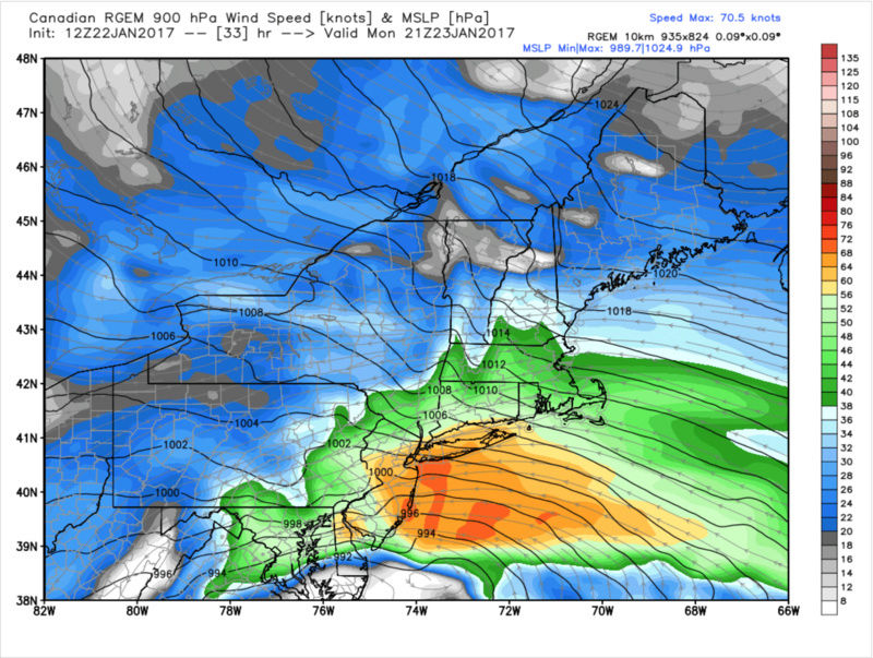
RGEM WINDS ARE UGLY
Just as a snapshot:

Just as a snapshot:

rb924119- Meteorologist

- Posts : 7112
Join date : 2013-02-06
 Re: January 22nd-24th Nor'easter Observations & Discussions
Aresian. Remember what you promised me!!!!
Guest- Guest
 Re: January 22nd-24th Nor'easter Observations & Discussions
sroc4 wrote:Where is the 850 closed low?
Tracks just off the NJ coast. Again, this is east of last night, which had it over NJ. Huge changes. I knew modeling didn't look right trying to ram this thing head on into that block aha
rb924119- Meteorologist

- Posts : 7112
Reputation : 195
Join date : 2013-02-06
Age : 32
Location : Greentown, Pa
 Re: January 22nd-24th Nor'easter Observations & Discussions
rb924119 wrote:sroc4 wrote:Where is the 850 closed low?
Tracks just off the NJ coast. Again, this is east of last night, which had it over NJ. Huge changes. I knew modeling didn't look right trying to ram this thing head on into that block aha
I am so behind on this system. I haven't looked at any details on actual models at all. Ive only been following the forum. Ive been so under the weather, no pun intended, since Thursday. Keep up the good job all.
_________________
"In weather and in life, there's no winning and losing; there's only winning and learning."
WINTER 2012/2013 TOTALS 43.65"WINTER 2017/2018 TOTALS 62.85" WINTER 2022/2023 TOTALS 4.9"
WINTER 2013/2014 TOTALS 64.85"WINTER 2018/2019 TOTALS 14.25" WINTER 2023/2024 TOTALS 13.1"
WINTER 2014/2015 TOTALS 71.20"WINTER 2019/2020 TOTALS 6.35" WINTER 2024/2025 TOTALS 0.00
WINTER 2015/2016 TOTALS 35.00"WINTER 2020/2021 TOTALS 37.75"
WINTER 2016/2017 TOTALS 42.25"WINTER 2021/2022 TOTALS 31.65"

sroc4- Admin

- Posts : 8458
Reputation : 302
Join date : 2013-01-07
Location : Wading River, LI
 Re: January 22nd-24th Nor'easter Observations & Discussions
CPcantmeasuresnow wrote:Frank_Wx wrote:Holy crap
Frank that model has consistently shown a small 15-20 inch area directly over where Doc and I live since yesterday and is getting some support form the NAM so I'm wondering how serious to take it now.
I realize it's almost all sleet but if it verifies 4-5 inches of sleet would be a huge problem. I'm more concerned about that right now than the winds here.
CP, the last time I saw sleet of that magnitude was the March 1993 storm where in Mahwah the snow changed to heavy sleet and 3 inches of that fell.There was about 17 inches of snow/sleet on the ground, a real joy to shovel.
Thinking this is a clown map, gonna be nowcast for us when this goes down.rjb just reported an east shift.Let's hope that trend continues to get us into more snow.
Last edited by docstox12 on Sun Jan 22, 2017 11:11 am; edited 1 time in total

docstox12- Wx Statistician Guru

- Posts : 8617
Reputation : 222
Join date : 2013-01-07
Age : 74
Location : Monroe NY
 Re: January 22nd-24th Nor'easter Observations & Discussions
Based on the p-type maps of the 12z CMC.........INTERIOR SNOWS. Awaiting the rest of the maps.
rb924119- Meteorologist

- Posts : 7112
Reputation : 195
Join date : 2013-02-06
Age : 32
Location : Greentown, Pa
 Re: January 22nd-24th Nor'easter Observations & Discussions
H5 IDENTICAL TO RGEM!! EXITS OFF THE NC/VA BORDER
rb924119- Meteorologist

- Posts : 7112
Reputation : 195
Join date : 2013-02-06
Age : 32
Location : Greentown, Pa
 Re: January 22nd-24th Nor'easter Observations & Discussions
It isn't as wet, with 1-2.5" liquid equivalent region-wide, but the winds are still rough for the coast, although not as nasty as the RGEM. Interior doesn't look as bad, but more substantially so based on a quick look. Kinda busy so I can't look at soundings, but I will later.
rb924119- Meteorologist

- Posts : 7112
Reputation : 195
Join date : 2013-02-06
Age : 32
Location : Greentown, Pa
 Re: January 22nd-24th Nor'easter Observations & Discussions
Snow map is a bit disappointing, so there must be a warm nose somewhere in this run still. Just northwest of everybody, except Aresian lol he likes it, although the double-digit snows are through northeastern NY and east.
rb924119- Meteorologist

- Posts : 7112
Reputation : 195
Join date : 2013-02-06
Age : 32
Location : Greentown, Pa
 Re: January 22nd-24th Nor'easter Observations & Discussions
RB for this to trend colder, we need of course the H5 to shift east in upcoming runs, but also the storm itself to continue to move at a slower pace overall. That will allow our high to the north to bleed in colder air and eradicate the stubborn warm wedge. The way this storm is starting to shape up, I can most certainly see this being a redux of VD 2007. For those who don't remember that storm, the city and nearby suburbs had a massive sleet storm, while the interior had heavy snows. After giving up on this storm as far as frozen precipitation is concerned, its now really peaking my interest once again.rb924119 wrote:Based on the p-type maps of the 12z CMC.........INTERIOR SNOWS. Awaiting the rest of the maps.

nutleyblizzard- Senior Enthusiast

- Posts : 1964
Reputation : 41
Join date : 2014-01-30
Age : 58
Location : Nutley, new jersey
 Re: January 22nd-24th Nor'easter Observations & Discussions
Central NYS and North of I90 are the most likely spots for any real accumlations of snow and/or sleet. I expect a rain/sleet mixture with little accums and I'm in the HV about 25 miles north of I84.

hyde345- Pro Enthusiast

- Posts : 1084
Reputation : 48
Join date : 2013-01-08
Location : Hyde Park, NY
 Re: January 22nd-24th Nor'easter Observations & Discussions
GFS is a low resolution model. I wouldn't worry much at this point what it shows verbatim at the surface.rb924119 wrote:Snow map is a bit disappointing, so there must be a warm nose somewhere in this run still. Just northwest of everybody, except Aresian lol he likes it, although the double-digit snows are through northeastern NY and east.

nutleyblizzard- Senior Enthusiast

- Posts : 1964
Reputation : 41
Join date : 2014-01-30
Age : 58
Location : Nutley, new jersey
 Re: January 22nd-24th Nor'easter Observations & Discussions
nutleyblizzard wrote:RB for this to trend colder, we need of course the H5 to shift east in upcoming runs, but also the storm itself to continue to move at a slower pace overall. That will allow our high to the north to bleed in colder air and eradicate the stubborn warm wedge. The way this storm is starting to shape up, I can most certainly see this being a redux of VD 2007. For those who don't remember that storm, the city and nearby suburbs had a massive sleet storm, while the interior had heavy snows. After giving up on this storm as far as frozen precipitation is concerned, its now really peaking my interest once again.rb924119 wrote:Based on the p-type maps of the 12z CMC.........INTERIOR SNOWS. Awaiting the rest of the maps.
Agreed. But here's another thought; what if the models are kicking H5 east because they're finally sensing the true strength of the block, and therefore, are still lagging with how quickly that cold air filters down? If that's the case, the speed of our system won't matter, per se', because the speed with which the cold air arrives will speed up in the modeling. Do you kind of see what I'm getting at? I agree 100% with you that we'd be in business if it slowed down, but there could also be another way to look at it, that's all.
rb924119- Meteorologist

- Posts : 7112
Reputation : 195
Join date : 2013-02-06
Age : 32
Location : Greentown, Pa
 Re: January 22nd-24th Nor'easter Observations & Discussions
nutleyblizzard wrote:GFS is a low resolution model. I wouldn't worry much at this point what it shows verbatim at the surface.rb924119 wrote:Snow map is a bit disappointing, so there must be a warm nose somewhere in this run still. Just northwest of everybody, except Aresian lol he likes it, although the double-digit snows are through northeastern NY and east.
If you mean the CMC, I again agree 100% haha
rb924119- Meteorologist

- Posts : 7112
Reputation : 195
Join date : 2013-02-06
Age : 32
Location : Greentown, Pa
 Re: January 22nd-24th Nor'easter Observations & Discussions
docstox12 wrote:CPcantmeasuresnow wrote:Frank_Wx wrote:Holy crap
Frank that model has consistently shown a small 15-20 inch area directly over where Doc and I live since yesterday and is getting some support form the NAM so I'm wondering how serious to take it now.
I realize it's almost all sleet but if it verifies 4-5 inches of sleet would be a huge problem. I'm more concerned about that right now than the winds here.
CP, the last time I saw sleet of that magnitude was the March 1993 storm where in Mahwah the snow changed to heavy sleet and 3 inches of that fell.There was about 17 inches of snow/sleet on the ground, a real joy to shovel.
Thinking this is a clown map, gonna be nowcast for us when this goes down.rjb just reported an east shift.Let's hope that trend continues to get us into more snow.
A nowcast for sure Doc.
The way the trends are right now I see us with a minimum of several hours of frozen precip (most likely sleet) at some point during this event. The trend does seem to be colder since yesterday and continues to be so on subsequent runs. The dynamics with storms of this intensity do some really weird things at the last minute, sometimes positive sometimes negative thus the nowcast beginning tomorrow.

CPcantmeasuresnow- Wx Statistician Guru

- Posts : 7288
Reputation : 230
Join date : 2013-01-07
Age : 103
Location : Eastern Orange County, NY
 Re: January 22nd-24th Nor'easter Observations & Discussions
syosnow94 wrote:Aresian. Remember what you promised me!!!!
I remember. A picture of one SnowKing Syo will be posted if this is all snow.
Guest- Guest
 Re: January 22nd-24th Nor'easter Observations & Discussions
We want the H5 to trend east, but if it goes too far east we could very well lose the dynamics of the storm. With limited cold air, its the old thread the needle!rb924119 wrote:nutleyblizzard wrote:RB for this to trend colder, we need of course the H5 to shift east in upcoming runs, but also the storm itself to continue to move at a slower pace overall. That will allow our high to the north to bleed in colder air and eradicate the stubborn warm wedge. The way this storm is starting to shape up, I can most certainly see this being a redux of VD 2007. For those who don't remember that storm, the city and nearby suburbs had a massive sleet storm, while the interior had heavy snows. After giving up on this storm as far as frozen precipitation is concerned, its now really peaking my interest once again.rb924119 wrote:Based on the p-type maps of the 12z CMC.........INTERIOR SNOWS. Awaiting the rest of the maps.
Agreed. But here's another thought; what if the models are kicking H5 east because they're finally sensing the true strength of the block, and therefore, are still lagging with how quickly that cold air filters down? If that's the case, the speed of our system won't matter, per se', because the speed with which the cold air arrives will speed up in the modeling. Do you kind of see what I'm getting at? I agree 100% with you that we'd be in business if it slowed down, but there could also be another way to look at it, that's all.

nutleyblizzard- Senior Enthusiast

- Posts : 1964
Reputation : 41
Join date : 2014-01-30
Age : 58
Location : Nutley, new jersey
 Re: January 22nd-24th Nor'easter Observations & Discussions
CPcantmeasuresnow wrote:docstox12 wrote:CPcantmeasuresnow wrote:Frank_Wx wrote:Holy crap
Frank that model has consistently shown a small 15-20 inch area directly over where Doc and I live since yesterday and is getting some support form the NAM so I'm wondering how serious to take it now.
I realize it's almost all sleet but if it verifies 4-5 inches of sleet would be a huge problem. I'm more concerned about that right now than the winds here.
CP, the last time I saw sleet of that magnitude was the March 1993 storm where in Mahwah the snow changed to heavy sleet and 3 inches of that fell.There was about 17 inches of snow/sleet on the ground, a real joy to shovel.
Thinking this is a clown map, gonna be nowcast for us when this goes down.rjb just reported an east shift.Let's hope that trend continues to get us into more snow.
A nowcast for sure Doc.
The way the trends are right now I see us with a minimum of several hours of frozen precip (most likely sleet) at some point during this event. The trend does seem to be colder since yesterday and continues to be so on subsequent runs. The dynamics with storms of this intensity do some really weird things at the last minute, sometimes positive sometimes negative thus the nowcast beginning tomorrow.
Thinking this is a great way to approach this CP.Expect maybe 1/2 to an inch of sleet during the heaviest dynamic of precip.NWS on board with that ATM.East trend encouraging, it's made a boring heavy rainstorm into something more interesting to observe tomorrow.Let's hope the east trend continues and finally HELPS us up here by taking us into more snow!!!
Last edited by docstox12 on Sun Jan 22, 2017 11:45 am; edited 1 time in total

docstox12- Wx Statistician Guru

- Posts : 8617
Reputation : 222
Join date : 2013-01-07
Age : 74
Location : Monroe NY
 Re: January 22nd-24th Nor'easter Observations & Discussions
nutleyblizzard wrote:We want the H5 to trend east, but if it goes too far east we could very well lose the dynamics of the storm. With limited cold air, its the old thread the needle!rb924119 wrote:nutleyblizzard wrote:RB for this to trend colder, we need of course the H5 to shift east in upcoming runs, but also the storm itself to continue to move at a slower pace overall. That will allow our high to the north to bleed in colder air and eradicate the stubborn warm wedge. The way this storm is starting to shape up, I can most certainly see this being a redux of VD 2007. For those who don't remember that storm, the city and nearby suburbs had a massive sleet storm, while the interior had heavy snows. After giving up on this storm as far as frozen precipitation is concerned, its now really peaking my interest once again.rb924119 wrote:Based on the p-type maps of the 12z CMC.........INTERIOR SNOWS. Awaiting the rest of the maps.
Agreed. But here's another thought; what if the models are kicking H5 east because they're finally sensing the true strength of the block, and therefore, are still lagging with how quickly that cold air filters down? If that's the case, the speed of our system won't matter, per se', because the speed with which the cold air arrives will speed up in the modeling. Do you kind of see what I'm getting at? I agree 100% with you that we'd be in business if it slowed down, but there could also be another way to look at it, that's all.
Haha well that's true, but it would have to swing another 100-200 miles, which is possible, but I think unlikely. Never know though lol
rb924119- Meteorologist

- Posts : 7112
Reputation : 195
Join date : 2013-02-06
Age : 32
Location : Greentown, Pa
 Re: January 22nd-24th Nor'easter Observations & Discussions
If it swings much farther east, it's going to pull the snow band away from my area. Or at least snow of any significance.
Guest- Guest
 Re: January 22nd-24th Nor'easter Observations & Discussions
UKMET looking sexy on the classic map. Looks like the GFS. Waiting for more maps.
rb924119- Meteorologist

- Posts : 7112
Reputation : 195
Join date : 2013-02-06
Age : 32
Location : Greentown, Pa
 Re: January 22nd-24th Nor'easter Observations & Discussions
Big changes aloft with the 12z runs! Can't wait for the EURO and more importantly tonights 00z runs!!!rb924119 wrote:UKMET looking sexy on the classic map. Looks like the GFS. Waiting for more maps.

nutleyblizzard- Senior Enthusiast

- Posts : 1964
Reputation : 41
Join date : 2014-01-30
Age : 58
Location : Nutley, new jersey
 Re: January 22nd-24th Nor'easter Observations & Discussions
I hope this storm goes to hell
_________________
_______________________________________________________________________________________________________
CLICK HERE to view NJ Strong Snowstorm Classifications
 Re: January 22nd-24th Nor'easter Observations & Discussions
Will it be considered bad manners to celebrate if I get a bunch of snow? Or is it okay just so long as I keep it off the board?
Guest- Guest
 Re: January 22nd-24th Nor'easter Observations & Discussions
Finally got my wind advisory. Gotta love the last second drama. Can't forget that this storm has caused at least 11 fatalities.

Grselig- Senior Enthusiast

- Posts : 1410
Reputation : 140
Join date : 2013-03-04
Age : 54
Location : Wayne NJ
 Re: January 22nd-24th Nor'easter Observations & Discussions
TheAresian wrote:Will it be considered bad manners to celebrate if I get a bunch of snow? Or is it okay just so long as I keep it off the board?
Absolutely, Aresian, celebrate Man, your area has been in a snow hole for years.Can't remember the last time a major snowstorm hit your area.But be wary of the S and E trend!!! Time after time it carries the heaviest snow away.At least where I am in the HV.Good Luck!!!
If the heavy stuff hits you, please post if you can reports during the day.

docstox12- Wx Statistician Guru

- Posts : 8617
Reputation : 222
Join date : 2013-01-07
Age : 74
Location : Monroe NY
Page 12 of 43 •  1 ... 7 ... 11, 12, 13 ... 27 ... 43
Page 12 of 43
Permissions in this forum:
You cannot reply to topics in this forum
 Home
Home