January 22nd-24th Nor'easter Observations & Discussions
+49
HectorO
2004blackwrx
essexcountypete
Sparky Sparticles
RJB8525
bobjohnsonforthehall
dsix85
Quietace
Deweydave
oldtimer
justdrew
Math23x7
Vinnydula
Fededle22
roccuweather
Radz
Dtone
sabamfa
deblanka
mikeypizano
larryrock72
Grselig
hyde345
jake732
obsessedwithweather
GreyBeard
Joe Snow
devsman
SoulSingMG
nutleyblizzard
aiannone
rb924119
sroc4
docstox12
Armando Salvadore
frank 638
billg315
Dunnzoo
amugs
Snow88
algae888
Sanchize06
CPcantmeasuresnow
weatherwatchermom
track17
skinsfan1177
dkodgis
jmanley32
Frank_Wx
53 posters
Page 19 of 43
Page 19 of 43 •  1 ... 11 ... 18, 19, 20 ... 31 ... 43
 Re: January 22nd-24th Nor'easter Observations & Discussions
The nam is slower by any 2 to 3 hours slower which means longer duration of wind
skinsfan1177- Senior Enthusiast

- Posts : 4485
Join date : 2013-01-07
 Re: January 22nd-24th Nor'easter Observations & Discussions
NAM shows things being particularly nasty after about 7 p.m. It looks like at hour 30 (around 1 a.m. Tue.) some cold air tries to poke into N. Jersey. Maybe we get some sleet around that time.
billg315- Advanced Forecaster - Mod

- Posts : 4564
Join date : 2015-01-24
 Re: January 22nd-24th Nor'easter Observations & Discussions
track17 wrote:So bling wind or rain really won't be an issue tomorrow morning then? I am safe until the ride home ?
I don't see there being major impacts for the morning rush hour. It might be windy, but I don't think we'll see much rain at that point. I think the more difficult commute will be the PM rush by far. Anytime after midday I think things go downhill rapidly.

billg315- Advanced Forecaster - Mod

- Posts : 4564
Reputation : 185
Join date : 2015-01-24
Age : 50
Location : Flemington, NJ
 Re: January 22nd-24th Nor'easter Observations & Discussions
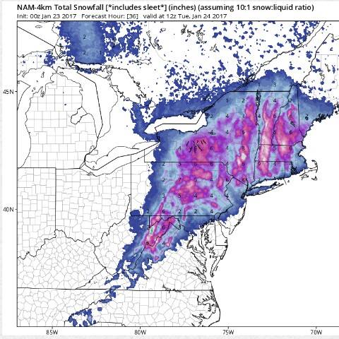
0z Nam coming in warmer for southern areas, still cold enough for snow/sleet well North and West
_________________
-Alex Iannone-

aiannone- Senior Enthusiast - Mod

- Posts : 4828
Reputation : 92
Join date : 2013-01-07
Location : Saint James, LI (Northwest Suffolk Co.)
 Re: January 22nd-24th Nor'easter Observations & Discussions
Ok that is good schools will have no problem with this storm then. Thanks for the help
track17- Posts : 454
Reputation : 4
Join date : 2016-01-09
 Re: January 22nd-24th Nor'easter Observations & Discussions
[quote="track17"]Ok that is good schools will have no problem with this storm then. Thanks for the help[/quote
Some schools already.
Closings Last Updated at 9:18pm on 1/22/2017
Hudson County
Saint Dominic Academy
Jersey City Closed - 1/23/2017
Monmouth County
Monmouth Regional High School
Tinton Falls Closing at 12:15 PM - 1/23/2017
No after school activities]
Some schools already.
Closings Last Updated at 9:18pm on 1/22/2017
Hudson County
Saint Dominic Academy
Jersey City Closed - 1/23/2017
Monmouth County
Monmouth Regional High School
Tinton Falls Closing at 12:15 PM - 1/23/2017
No after school activities]

skinsfan1177- Senior Enthusiast

- Posts : 4485
Reputation : 35
Join date : 2013-01-07
Age : 47
Location : Point Pleasant Boro
 Re: January 22nd-24th Nor'easter Observations & Discussions
Yeah, it's already pretty windy and the NAM doesn't even have the strongest winds getting here until about 6pm. Then heavy rain and 40+mph sustained from then into the overnight hours.
skinsfan1177 wrote:The nam is slower by any 2 to 3 hours slower which means longer duration of wind
Sanchize06- Senior Enthusiast

- Posts : 1041
Reputation : 21
Join date : 2013-02-05
Location : Union Beach, NJ
 Re: January 22nd-24th Nor'easter Observations & Discussions
The winds have significantly picked up in upper Manhattan in the last hour. This is going to be a beast of a storm.

SoulSingMG- Senior Enthusiast

- Posts : 2853
Reputation : 74
Join date : 2013-12-11
Location : Long Island City, NY
 Re: January 22nd-24th Nor'easter Observations & Discussions
Also hearing hi res nam is colder, can't wait to see maps

skinsfan1177- Senior Enthusiast

- Posts : 4485
Reputation : 35
Join date : 2013-01-07
Age : 47
Location : Point Pleasant Boro
 Re: January 22nd-24th Nor'easter Observations & Discussions
But the ocean county public schools look to be good skins
track17- Posts : 454
Reputation : 4
Join date : 2016-01-09
 Re: January 22nd-24th Nor'easter Observations & Discussions
track17 wrote:But the ocean county public schools look to be good skins
Yes so far so good.

skinsfan1177- Senior Enthusiast

- Posts : 4485
Reputation : 35
Join date : 2013-01-07
Age : 47
Location : Point Pleasant Boro
 Re: January 22nd-24th Nor'easter Observations & Discussions
Where are some of the guys mugs,rb,frank,sroc,algae lol

skinsfan1177- Senior Enthusiast

- Posts : 4485
Reputation : 35
Join date : 2013-01-07
Age : 47
Location : Point Pleasant Boro
 Re: January 22nd-24th Nor'easter Observations & Discussions
Great to hear no reason to. Thanks for the help
track17- Posts : 454
Reputation : 4
Join date : 2016-01-09
 Re: January 22nd-24th Nor'easter Observations & Discussions
Well sroc has been under the weather (pardon the pun) and that's why he hasn't checked in much the last few days. rb disappeared to do some deeper analysis a few hours ago and never re-appeared. Frank was away for a bit but returned short time ago. My guess is he is catching up on what he missed while away and will fill us in if he thinks any update is needed. That's the best I can do. Lol.skinsfan1177 wrote:Where are some of the guys mugs,rb,frank,sroc,algae lol

billg315- Advanced Forecaster - Mod

- Posts : 4564
Reputation : 185
Join date : 2015-01-24
Age : 50
Location : Flemington, NJ
 Re: January 22nd-24th Nor'easter Observations & Discussions
Winds have picked up here 25mph gust

Vinnydula- Pro Enthusiast

- Posts : 778
Reputation : 8
Join date : 2013-12-12
Location : Dobbs ferry

aiannone- Senior Enthusiast - Mod

- Posts : 4828
Reputation : 92
Join date : 2013-01-07
Location : Saint James, LI (Northwest Suffolk Co.)
 Re: January 22nd-24th Nor'easter Observations & Discussions
billg315 wrote:Well sroc has been under the weather (pardon the pun) and that's why he hasn't checked in much the last few days. rb disappeared to do some deeper analysis a few hours ago and never re-appeared. Frank was away for a bit but returned short time ago. My guess is he is catching up on what he missed while away and will fill us in if he thinks any update is needed. That's the best I can do. Lol.skinsfan1177 wrote:Where are some of the guys mugs,rb,frank,sroc,algae lol
Rumor has it that Mugs is drooling uncontrollably and can't make it to the computer. Exciting times!

Grselig- Senior Enthusiast

- Posts : 1410
Reputation : 140
Join date : 2013-03-04
Age : 54
Location : Wayne NJ
 Re: January 22nd-24th Nor'easter Observations & Discussions
Ripped from my Facebook:
Here is my first, although not necessarily final call, as this is a very dynamic system with high bust potential:
Start: 4-7am south, expanding through northern zones through tomorrow
End: 3-6pm Tuesday
An approaching deep mid-level disturbance that is currently barreling through the southern U.S. will eventually begin to turn northward overnight. As it does, it will work to spread a large shield of heavy precipitation from south to north across our region through the day tomorrow. For areas in green, only rain, but heavy rain, is expected. For areas in grey, the precipitation will alternate between periods of rain and sleet. For the blues, this is where mostly wintry precipitation is expected. When it first starts in these areas, it will likely be rain, but as the precipitation quickly increases in intensity and colder air continues to filter in from the north and northeast, it will transition to a mix of sleet and snow or mostly snow depending on your exact location. The change to the wintry precipitation will occur from south to north from the late morning through the afternoon the further north you are. Through central NY and central New England, the precipitation will start wintry as it will be colder to start, but mix with some sleet along the southern periphery as the storm gets to its nearest point Monday evening into Tuesday morning.
The second component to this system will be the strong winds, as depicted in the second graphic. With the soft ground, uprooted trees among other tree damage and power outages are likely to occur for parts of the area.
A third component is the coastal impact, which will feature a 3-5 foot storm surge, minor coastal flooding and major beach erosion, with waves ranging from 10-16 feet inshore. Again, this is a very dynamic system with many parts, so this forecast is not necessarily my final, and has high bust potential depending on several factors. Stay tuned for the latest updates and information!!


Last edited by rb924119 on Sun Jan 22, 2017 9:46 pm; edited 1 time in total
rb924119- Meteorologist

- Posts : 7112
Reputation : 195
Join date : 2013-02-06
Age : 32
Location : Greentown, Pa
 Re: January 22nd-24th Nor'easter Observations & Discussions
aiannone wrote:0z NAM
Well that's a great forecast if you're in State College, PA. Not good news for anyone else looking for snow other than maybe Aresian. Doesn't even look as good for you Alex.

billg315- Advanced Forecaster - Mod

- Posts : 4564
Reputation : 185
Join date : 2015-01-24
Age : 50
Location : Flemington, NJ
 Re: January 22nd-24th Nor'easter Observations & Discussions
Really don't think there will be much of a change from the map Frank posted earlier, so probably taking a break and watching the games...
_________________
Janet
Snowfall winter of 2023-2024 17.5"
Snowfall winter of 2022-2023 6.0"
Snowfall winter of 2021-2022 17.6" 1" sleet 2/25/22
Snowfall winter of 2020-2021 51.1"
Snowfall winter of 2019-2020 8.5"
Snowfall winter of 2018-2019 25.1"
Snowfall winter of 2017-2018 51.9"
Snowfall winter of 2016-2017 45.6"
Snowfall winter of 2015-2016 29.5"
Snowfall winter of 2014-2015 50.55"
Snowfall winter of 2013-2014 66.5"
Dunnzoo- Senior Enthusiast - Mod

- Posts : 4937
Reputation : 68
Join date : 2013-01-11
Age : 62
Location : Westwood, NJ
 Re: January 22nd-24th Nor'easter Observations & Discussions
rb924119 wrote:Here is my first, although not necessarily final call, as this is a very dynamic system with high bust potential:
Start: 4-7am south, expanding through northern zones through tomorrow
End: 3-6pm Tuesday
An approaching deep mid-level disturbance that is currently barreling through the southern U.S. will eventually begin to turn northward overnight. As it does, it will work to spread a large shield of heavy precipitation from south to north across our region through the day tomorrow. For areas in green, only rain, but heavy rain, is expected. For areas in grey, the precipitation will alternate between periods of rain and sleet. For the blues, this is where mostly wintry precipitation is expected. When it first starts in these areas, it will likely be rain, but as the precipitation quickly increases in intensity and colder air continues to filter in from the north and northeast, it will transition to a mix of sleet and snow or mostly snow depending on your exact location. The change to the wintry precipitation will occur from south to north from the late morning through the afternoon the further north you are. Through central NY and central New England, the precipitation will start wintry as it will be colder to start, but mix with some sleet along the southern periphery as the storm gets to its nearest point Monday evening into Tuesday morning.
The second component to this system will be the strong winds, as depicted in the second graphic. With the soft ground, uprooted trees among other tree damage and power outages are likely to occur for parts of the area.
A third component is the coastal impact, which will feature a 3-5 foot storm surge, minor coastal flooding and major beach erosion, with waves ranging from 10-16 feet inshore. Again, this is a very dynamic system with many parts, so this forecast is not necessarily my final, and has high bust potential depending on several factors. Stay tuned for the latest updates and information!!
Great maps, interesting how Albany seems to think warmer for VT and areas east with western areas such as NY being the coldest.
_________________
-Alex Iannone-

aiannone- Senior Enthusiast - Mod

- Posts : 4828
Reputation : 92
Join date : 2013-01-07
Location : Saint James, LI (Northwest Suffolk Co.)
 Re: January 22nd-24th Nor'easter Observations & Discussions
Why is the 4k NAM always colder?
_________________
-Alex Iannone-

aiannone- Senior Enthusiast - Mod

- Posts : 4828
Reputation : 92
Join date : 2013-01-07
Location : Saint James, LI (Northwest Suffolk Co.)
 Re: January 22nd-24th Nor'easter Observations & Discussions
Dunnzoo wrote:Really don't think there will be much of a change from the map Frank posted earlier, so probably taking a break and watching the games...
After assessing latest data I can tell you I feel even more confident about the map I posted.
Ray - we almost agree if it weren't for your snow amounts. However, I can definitely see how these will happen based on elevation. It will be fascinating to watch unfold.
_________________
_______________________________________________________________________________________________________
CLICK HERE to view NJ Strong Snowstorm Classifications
 Re: January 22nd-24th Nor'easter Observations & Discussions
Thanks, Alex! And I honestly haven't read anything from the NWS, so I don't know their reasoning haha And I have no idea; is it really always colder?
rb924119- Meteorologist

- Posts : 7112
Reputation : 195
Join date : 2013-02-06
Age : 32
Location : Greentown, Pa
 Re: January 22nd-24th Nor'easter Observations & Discussions
rb924119 wrote:Thanks, Alex! And I honestly haven't read anything from the NWS, so I don't know their reasoning haha And I have no idea; is it really always colder?
Seems to be! I'll post it
_________________
-Alex Iannone-

aiannone- Senior Enthusiast - Mod

- Posts : 4828
Reputation : 92
Join date : 2013-01-07
Location : Saint James, LI (Northwest Suffolk Co.)

aiannone- Senior Enthusiast - Mod

- Posts : 4828
Reputation : 92
Join date : 2013-01-07
Location : Saint James, LI (Northwest Suffolk Co.)
 Re: January 22nd-24th Nor'easter Observations & Discussions
NAM 3km
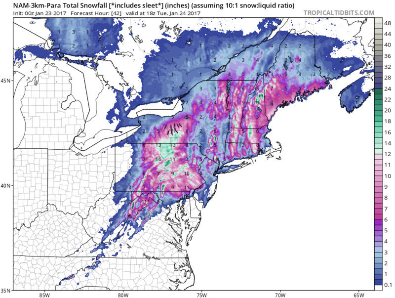
3 and 4km models seem to be at odds over whether the heaviest precip will be more east or west.

3 and 4km models seem to be at odds over whether the heaviest precip will be more east or west.
Guest- Guest
Page 19 of 43 •  1 ... 11 ... 18, 19, 20 ... 31 ... 43
Page 19 of 43
Permissions in this forum:
You cannot reply to topics in this forum
 Home
Home

