December 11th 2019 Snow Potential
+25
brownie
jaydoy
algae888
Dunnzoo
1190ftalt
Grselig
Scullybutcher
dkodgis
skinsfan1177
jimv45
hyde345
billg315
Math23x7
CPcantmeasuresnow
frank 638
heehaw453
aiannone
amugs
docstox12
SENJsnowman
weatherwatchermom
Frank_Wx
jmanley32
Irish
sroc4
29 posters
Page 1 of 9 • 1, 2, 3, 4, 5, 6, 7, 8, 9 
 December 11th 2019 Snow Potential
sroc4 wrote:Pretty easy to see that there are still MAJOR differences in the evolution at 500 between euro and GFS. NAM CMC Ukie all look much more like euro. On the Euro map below 6 hours faster to the Vort max digging in from the north located over the NW GL and you start to phase energy and a LP will pop.
So how does the comparison of the Euro looking like the CMC not treanslate the same at the surface? Euro has all rain mostly,whereas CMC has a warning level snow for most, I dunno what UKIE has. Are you leaning towards snow or rain? I know its going to initially be a rain storm monday/tuesday but then it looks to change but then I wonder after all that rain will it even be able to stick.
So Jman and everyone else. A quick down and dirty analysis.
A warm front approaches our area late tonight into the early morning hrs Monday. Depending on exactly where you live Precip in the form of rain will break out prob between about 5am-9am tomorrow am. As the day progresses rain will become more steady and increase in intensity and likely last well into Monday eve and overnight hr. By the early morning hrs on Tuesday there should be a break in the the rain and most of Tuesday will be hit or miss showers and temps will warm as the warm front will have pushed up through the area.
By late afternoon on Tuesday, as you you can see below, temps are into the 50's and even 60's along the coastal plain.
As you can see the 32*f line on the surface is way up by the US/Canadian boarder. So how is it going to snow AND accumulate on Wed??
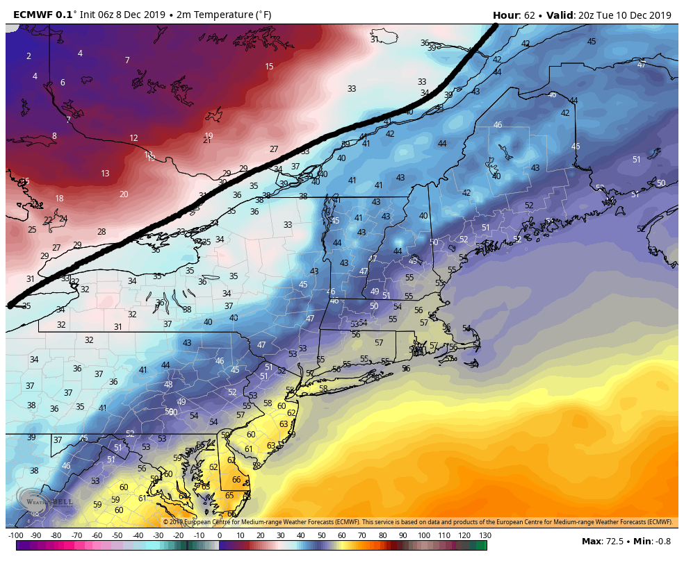
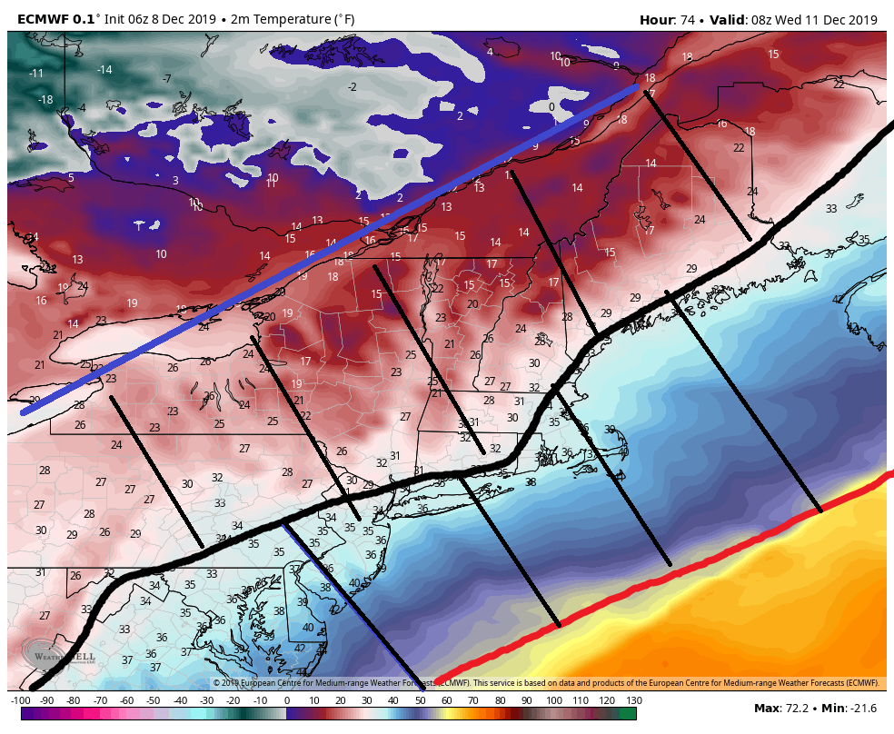
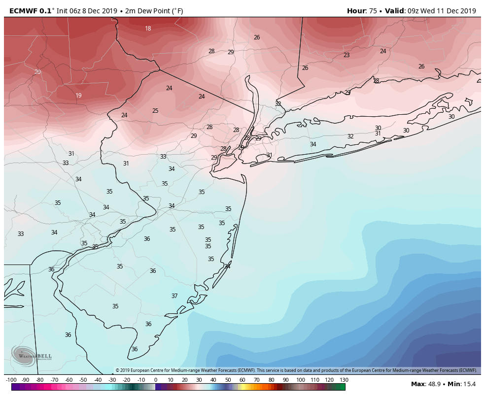
NOTE: First image about is valid for approx 4pm Tuesday; the second and third image above are valid 4am Wed morning
So as you can see above a cold front will crash the area overnight Tuesday into Wed such that a mere 12hrs(+/-) the 32*f surface line(second image above) is now essentially down to the coast, and 2meter dew points(third image) are crashing. An important feature I want to highlight in the second image above is take note at the temperature gradient. A mere 100-150 miles to the S&E separates the 60's and 70's from the freezing line. And a mere 100-150 miles N&W temps are in the teens. This sets up an impressive baroclinic zone along the cold frontal boundary that WILL enhance vertical lift.
Now I want to zoom out real quick and look at the big picture. Unlike the last storm set up the source region for the cold air behind the front is straight out of the Arctic and frigid Canadian tundra, because you have a steep ridge along the WC of NA and resultant arctic/polar trough digging into the Eastern CONUS. This is a key factor for a successful event here and is why the baroclinic zone I showed above sets up.
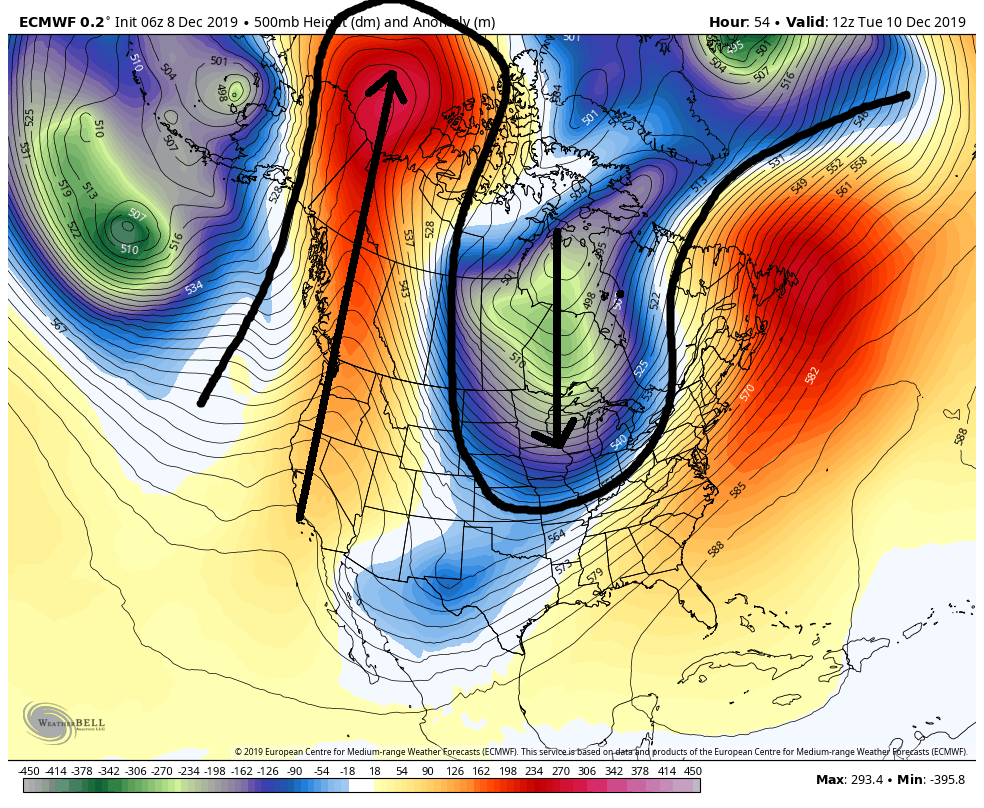
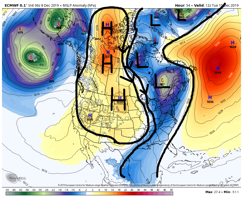
Now once the cold front sweeps through overnight Tuesday and into early Wed it should stall just to our SE. A new round of enhanced precip will develop Wed am. It will likely begin as light rain then begin to mix and change over to snow as we progress into mid-late am Wed from NW to SE as the arctic air sweeps in.
I think a general 1-3" for most of us on the board with possibly higher numbers (ie:3-6") is def doable in this set up. The reason for this is this:
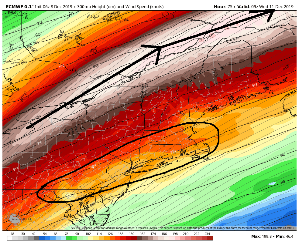
There will be a potent jet streak(JS) between 300-250mb favorably positioned to our north at just the right time. This should/would enhance lift in the areas I have circled if modeled correctly. This combined with the potent temp gradient I highlighted above should lead to a period of decent banding. As is always the case the banding will likely be in some areas and not in others. The most likely areas that will see the heavier banding will be along the coastal plain.
The final piece to the puzzle Id like to point out are snow ratios. As you can see by the 925mb and 850mb maps below respectively, the temps just above the surface will rapidly drive the snow ratios up. Once the Precip changes over snow ratios for everyone will get better and better as the event unfolds.

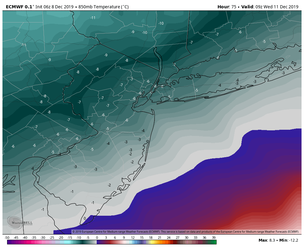

And so Jman to bring your original question back around full circle, I fully expect that the crashing arctic air combined with crashing dew points will rapidly cool the surface once the precip falls such that the enhanced lifting mechanisms outlined above, favorably positioned JS, and baroclinicically driven vertical lift enhancement, combined with climbing snow ratios will allow for everyone or almost every one to cash in on some accumulating snow fall on Wed.
Now a few quick notes on the models. Euro, CMC, GFS, (yes even the GFS) all shoiw what Im outlining above; however, the NAM which usually over does precip/QPF is actually showing very little in the way of precip as of current modeling. So we will see how this plays out as we head through today.
WE TRACK!!

_________________
"In weather and in life, there's no winning and losing; there's only winning and learning."
WINTER 2012/2013 TOTALS 43.65"WINTER 2017/2018 TOTALS 62.85" WINTER 2022/2023 TOTALS 4.9"
WINTER 2013/2014 TOTALS 64.85"WINTER 2018/2019 TOTALS 14.25" WINTER 2023/2024 TOTALS 13.1"
WINTER 2014/2015 TOTALS 71.20"WINTER 2019/2020 TOTALS 6.35" WINTER 2024/2025 TOTALS 0.00
WINTER 2015/2016 TOTALS 35.00"WINTER 2020/2021 TOTALS 37.75"
WINTER 2016/2017 TOTALS 42.25"WINTER 2021/2022 TOTALS 31.65"

sroc4- Admin

- Posts : 8457
Reputation : 302
Join date : 2013-01-07
Location : Wading River, LI
 Re: December 11th 2019 Snow Potential
Now, that was a cool breakdown!

Irish- Pro Enthusiast

- Posts : 788
Reputation : 19
Join date : 2019-01-16
Age : 46
Location : Old Bridge, NJ
 Re: December 11th 2019 Snow Potential
Thanks Sroc, great analysis and it makes sense now that you painted the picture, man the temps really change quick. Yes we track!

jmanley32- Senior Enthusiast

- Posts : 20641
Reputation : 108
Join date : 2013-12-12
Age : 43
Location : Yonkers, NY
 Re: December 11th 2019 Snow Potential
Thank you Scott for doing the analysis on this event. My initial thinking is everyone will enjoy a burst of moderate snowfall Wednesday morning as the temps crash. Rain will turn to snow and light accumulations will be widespread across the region. Because N&W of NYC will start colder, even some places starting as snow with high ratios, they will see higher accumulations of 3"+ while everyone say south & east of Morristown, NJ will be in the C-2" range.
_________________
_______________________________________________________________________________________________________
CLICK HERE to view NJ Strong Snowstorm Classifications
 Re: December 11th 2019 Snow Potential
Latest 12z NAM valid this Wednesday:
4am

7am:

10am:

TOTAL SNOW

6-10" of high ratio snow N&W of NYC. WOW
4am

7am:

10am:

TOTAL SNOW

6-10" of high ratio snow N&W of NYC. WOW
_________________
_______________________________________________________________________________________________________
CLICK HERE to view NJ Strong Snowstorm Classifications
 Re: December 11th 2019 Snow Potential
Frank_Wx wrote:Latest 12z NAM valid this Wednesday:
4am
7am:
10am:
TOTAL SNOW
6-10" of high ratio snow N&W of NYC. WOW
It’s very possible that as our S/R hi res models come into range we see just how much enhancement the JS and temp gradient can proved combined with ratios. The Trop tidbits map you posted was only 10:1
_________________
"In weather and in life, there's no winning and losing; there's only winning and learning."
WINTER 2012/2013 TOTALS 43.65"WINTER 2017/2018 TOTALS 62.85" WINTER 2022/2023 TOTALS 4.9"
WINTER 2013/2014 TOTALS 64.85"WINTER 2018/2019 TOTALS 14.25" WINTER 2023/2024 TOTALS 13.1"
WINTER 2014/2015 TOTALS 71.20"WINTER 2019/2020 TOTALS 6.35" WINTER 2024/2025 TOTALS 0.00
WINTER 2015/2016 TOTALS 35.00"WINTER 2020/2021 TOTALS 37.75"
WINTER 2016/2017 TOTALS 42.25"WINTER 2021/2022 TOTALS 31.65"

sroc4- Admin

- Posts : 8457
Reputation : 302
Join date : 2013-01-07
Location : Wading River, LI
 Re: December 11th 2019 Snow Potential
WE TRACK!!
 [/quote]
HOLY COW.. I thought I saw it was going to be 60 on Tues...did not pay attention to weather at all the last couple of days.I will say this we will probably have a blizzard...we have fantastic tickets to see Billy Joel on Wed night..so of course it will snow!!..lol Thank you for the great breakdown

weatherwatchermom- Senior Enthusiast

- Posts : 3891
Reputation : 78
Join date : 2014-11-25
Location : Hazlet Township, NJ
 Re: December 11th 2019 Snow Potential
Wow, great analysis SROC and Frank...thanks! And great questions JMAN, I was thinking the same things. Hard to believe 60's to accumulating snow in 15-18 hours, but such is the force that is nature.
The Jersey Shore has not had an intense, prolonged snowfall since the giant spring blizzard of '18. And I remember a few seasons recently where there was just no sign of snow down here until like mid-January. So, all this early season action, hit or miss, is awesome!
As far as the actual temp crash/heavy precip timing nature of the event, these tend to not work out well for the Jersey Coast due to warm noses and mid level intrusions and such. Not sure if that's in play here, but I figure it will be...usually is. So, low expectations, high hopes and ready to track!
SENJsnowman- Senior Enthusiast

- Posts : 1198
Reputation : 61
Join date : 2017-01-06
Age : 51
Location : Long Branch, NJ
 Re: December 11th 2019 Snow Potential
Top shelf analysis Doc, clear and understandable!
Did you ever think we would have all this tracking in early December?
Wooohooo.......
Did you ever think we would have all this tracking in early December?
Wooohooo.......

docstox12- Wx Statistician Guru

- Posts : 8609
Reputation : 222
Join date : 2013-01-07
Age : 74
Location : Monroe NY
 Re: December 11th 2019 Snow Potential
Peeps just think back to the Stuper Bowl of 2014 in NJ same type of set up. Rayno and Billy the Kid have been on this sun e last week.
60* during the day and BLAME!! ARCTIC FRONT swings in like Docs old lady friends and we get a snowstorm.
3-6" area wide to screw up rush hour and close schools or delay openings with 4-8" potential.
The jet streak is intense overhead which will expand and enhance the precip field.
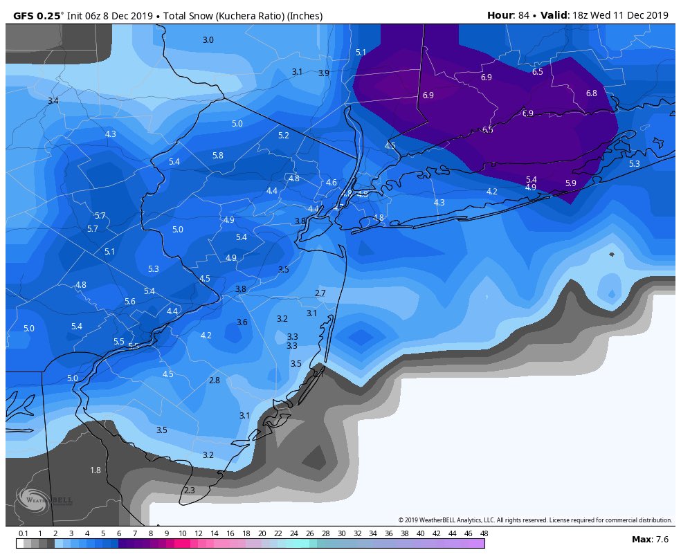
GFS for eye candy
60* during the day and BLAME!! ARCTIC FRONT swings in like Docs old lady friends and we get a snowstorm.
3-6" area wide to screw up rush hour and close schools or delay openings with 4-8" potential.
The jet streak is intense overhead which will expand and enhance the precip field.
GFS for eye candy

Last edited by amugs on Sun Dec 08, 2019 11:07 am; edited 1 time in total
_________________
Mugs
AKA:King: Snow Weenie
Self Proclaimed
WINTER 2014-15 : 55.12" +.02 for 6 coatings (avg. 35")
WINTER 2015-16 Total - 29.8" (Avg 35")
WINTER 2016-17 : 39.5" so far

amugs- Advanced Forecaster - Mod

- Posts : 15143
Reputation : 213
Join date : 2013-01-07
Age : 54
Location : Hillsdale,NJ
 Re: December 11th 2019 Snow Potential
12Z nam catching on. It’s the mesoscale models that will probably do best picking up on this type of set up so it’s a good sign!
_________________
-Alex Iannone-

aiannone- Senior Enthusiast - Mod

- Posts : 4826
Reputation : 92
Join date : 2013-01-07
Location : Saint James, LI (Northwest Suffolk Co.)
 Re: December 11th 2019 Snow Potential
I definitely see more energy on the models now in front of the trough which was part 1 of my concern. Part 2 of my concern would be surface temperatures and that still a big obstacle. I think the C-2" along and SE of 95 is probably a good call for now.
NW 2-4 seems reasonable for now.
Let's see how this trends in the next 24 hours, definitely more interested now.
Sounding for NE NJ - Mid levels plenty cold, but surface is the issue.
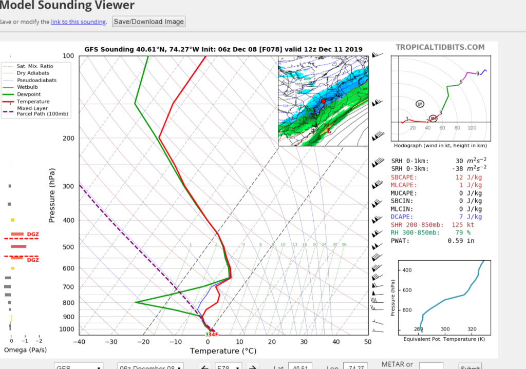
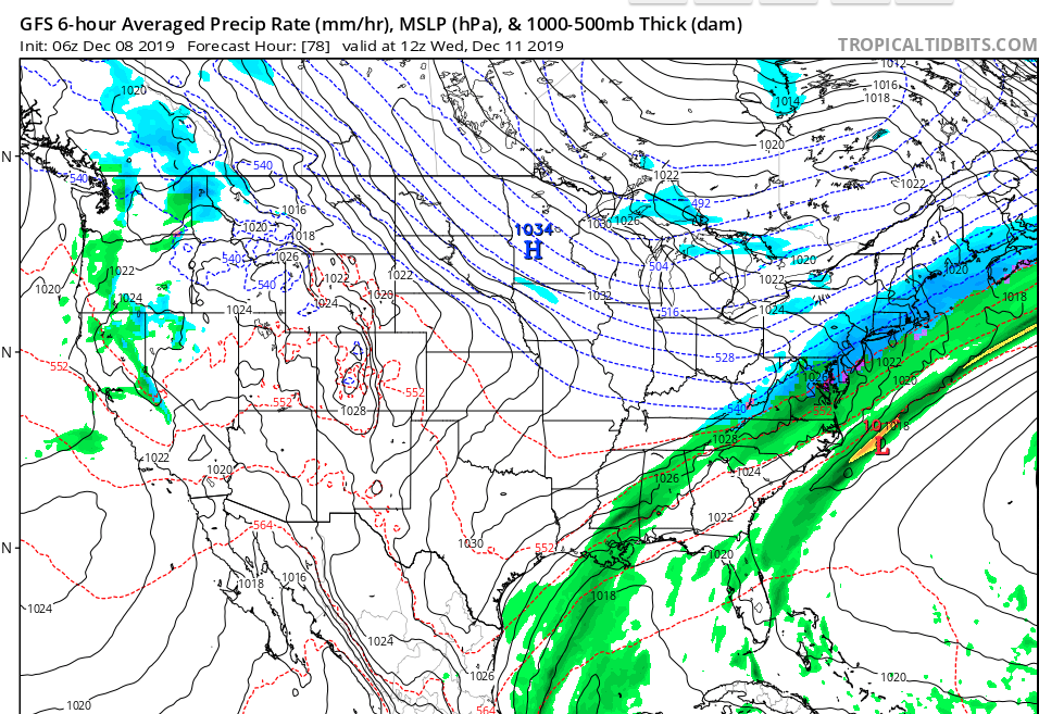
NW 2-4 seems reasonable for now.
Let's see how this trends in the next 24 hours, definitely more interested now.
Sounding for NE NJ - Mid levels plenty cold, but surface is the issue.


heehaw453- Advanced Forecaster

- Posts : 3926
Reputation : 86
Join date : 2014-01-20
Location : Bedminster Township, PA Elevation 600' ASL
 Re: December 11th 2019 Snow Potential
SENJsnowman wrote:Wow, great analysis SROC and Frank...thanks! And great questions JMAN, I was thinking the same things. Hard to believe 60's to accumulating snow in 15-18 hours, but such is the force that is nature.
The Jersey Shore has not had an intense, prolonged snowfall since the giant spring blizzard of '18. And I remember a few seasons recently where there was just no sign of snow down here until like mid-January. So, all this early season action, hit or miss, is awesome!
As far as the actual temp crash/heavy precip timing nature of the event, these tend to not work out well for the Jersey Coast due to warm noses and mid level intrusions and such. Not sure if that's in play here, but I figure it will be...usually is. So, low expectations, high hopes and ready to track!
Snow man. This set up isn’t going to involve any warm noses. This is all about where the front stalls and when not if the temps crash, then can you get under a heavier band. I know it’s 50-60* the afternoon before but this set up screams overachiever IMO for most.
_________________
"In weather and in life, there's no winning and losing; there's only winning and learning."
WINTER 2012/2013 TOTALS 43.65"WINTER 2017/2018 TOTALS 62.85" WINTER 2022/2023 TOTALS 4.9"
WINTER 2013/2014 TOTALS 64.85"WINTER 2018/2019 TOTALS 14.25" WINTER 2023/2024 TOTALS 13.1"
WINTER 2014/2015 TOTALS 71.20"WINTER 2019/2020 TOTALS 6.35" WINTER 2024/2025 TOTALS 0.00
WINTER 2015/2016 TOTALS 35.00"WINTER 2020/2021 TOTALS 37.75"
WINTER 2016/2017 TOTALS 42.25"WINTER 2021/2022 TOTALS 31.65"

sroc4- Admin

- Posts : 8457
Reputation : 302
Join date : 2013-01-07
Location : Wading River, LI
 Re: December 11th 2019 Snow Potential
_________________
-Alex Iannone-

aiannone- Senior Enthusiast - Mod

- Posts : 4826
Reputation : 92
Join date : 2013-01-07
Location : Saint James, LI (Northwest Suffolk Co.)
 Re: December 11th 2019 Snow Potential
GfS coming in colder sooner
_________________
"In weather and in life, there's no winning and losing; there's only winning and learning."
WINTER 2012/2013 TOTALS 43.65"WINTER 2017/2018 TOTALS 62.85" WINTER 2022/2023 TOTALS 4.9"
WINTER 2013/2014 TOTALS 64.85"WINTER 2018/2019 TOTALS 14.25" WINTER 2023/2024 TOTALS 13.1"
WINTER 2014/2015 TOTALS 71.20"WINTER 2019/2020 TOTALS 6.35" WINTER 2024/2025 TOTALS 0.00
WINTER 2015/2016 TOTALS 35.00"WINTER 2020/2021 TOTALS 37.75"
WINTER 2016/2017 TOTALS 42.25"WINTER 2021/2022 TOTALS 31.65"

sroc4- Admin

- Posts : 8457
Reputation : 302
Join date : 2013-01-07
Location : Wading River, LI
 Re: December 11th 2019 Snow Potential
Similar to 6z through 72. Snow is a bit More SE. sharp cutoff to the Nw
_________________
-Alex Iannone-

aiannone- Senior Enthusiast - Mod

- Posts : 4826
Reputation : 92
Join date : 2013-01-07
Location : Saint James, LI (Northwest Suffolk Co.)
 Re: December 11th 2019 Snow Potential
Interesting how the precip field just collapses after 72
_________________
-Alex Iannone-

aiannone- Senior Enthusiast - Mod

- Posts : 4826
Reputation : 92
Join date : 2013-01-07
Location : Saint James, LI (Northwest Suffolk Co.)
heehaw453- Advanced Forecaster

- Posts : 3926
Reputation : 86
Join date : 2014-01-20
Location : Bedminster Township, PA Elevation 600' ASL
 Re: December 11th 2019 Snow Potential
A coating to 2 inches might be a bit low no? Well still perfect timing to keep me home ad long as it's snowing in morning we likely won't go in.

jmanley32- Senior Enthusiast

- Posts : 20641
Reputation : 108
Join date : 2013-12-12
Age : 43
Location : Yonkers, NY
 Re: December 11th 2019 Snow Potential
Sroc thank you for your post I am very excited I hope we all get something snow 
 Out of this
frank 638- Senior Enthusiast

- Posts : 2877
Reputation : 37
Join date : 2016-01-01
Age : 41
Location : bronx ny
 Re: December 11th 2019 Snow Potential
sroc4 wrote:SENJsnowman wrote:Wow, great analysis SROC and Frank...thanks! And great questions JMAN, I was thinking the same things. Hard to believe 60's to accumulating snow in 15-18 hours, but such is the force that is nature.
The Jersey Shore has not had an intense, prolonged snowfall since the giant spring blizzard of '18. And I remember a few seasons recently where there was just no sign of snow down here until like mid-January. So, all this early season action, hit or miss, is awesome!
As far as the actual temp crash/heavy precip timing nature of the event, these tend to not work out well for the Jersey Coast due to warm noses and mid level intrusions and such. Not sure if that's in play here, but I figure it will be...usually is. So, low expectations, high hopes and ready to track!
Snow man. This set up isn’t going to involve any warm noses. This is all about where the front stalls and when not if the temps crash, then can you get under a heavier band. I know it’s 50-60* the afternoon before but this set up screams overachiever IMO for most.
Sweet...one less piece to the puzzle to sweat out! Now that I think about it, it makes sense. The arctic air gets here first and this is not a coastal with it's warm ocean air coming in the from the other side.
Hopefully the energy does organize and strengthen, and then we track these things you mentioned...and bingo! the lucky winners are under heavy precip rates just as the boundary stalls. Does that sound right?
SENJsnowman- Senior Enthusiast

- Posts : 1198
Reputation : 61
Join date : 2017-01-06
Age : 51
Location : Long Branch, NJ
 Re: December 11th 2019 Snow Potential
12z GFS starting to catch on, puts down 2-3" for most of the board and definitely seems to be strengthening and consolidating the southern energy. This run it actually seems to connect with the northern energy a bit more and for longer.
I have no idea if that makes a difference, but it seems to be in line with what HeeHaw was talking about. I think...
I have no idea if that makes a difference, but it seems to be in line with what HeeHaw was talking about. I think...
SENJsnowman- Senior Enthusiast

- Posts : 1198
Reputation : 61
Join date : 2017-01-06
Age : 51
Location : Long Branch, NJ
 Re: December 11th 2019 Snow Potential
SENJsnowman wrote:12z GFS starting to catch on, puts down 2-3" for most of the board and definitely seems to be strengthening and consolidating the southern energy. This run it actually seems to connect with the northern energy a bit more and for longer.
I have no idea if that makes a difference, but it seems to be in line with what HeeHaw was talking about. I think...
Hi Snowman
i think temperatures crashing at the 850mb mid-levels (5000 feet in the air) causes frontogenesis. This frontogenesis allows for lift and mod/heavy precip rates due the temperature gradients. If a wave forms on the temp boundary then the instability will be increased and enhance precip rates. I think that would be the way to get bigger accumulations in conjunction with the surface temps crashing fast enough. Probably won't know until mesoscale models come into focus. I have my expectations tempered because a lot of things have to go right.
heehaw453- Advanced Forecaster

- Posts : 3926
Reputation : 86
Join date : 2014-01-20
Location : Bedminster Township, PA Elevation 600' ASL
 Re: December 11th 2019 Snow Potential
Euro holds serve. Wide spread 2-5”
_________________
"In weather and in life, there's no winning and losing; there's only winning and learning."
WINTER 2012/2013 TOTALS 43.65"WINTER 2017/2018 TOTALS 62.85" WINTER 2022/2023 TOTALS 4.9"
WINTER 2013/2014 TOTALS 64.85"WINTER 2018/2019 TOTALS 14.25" WINTER 2023/2024 TOTALS 13.1"
WINTER 2014/2015 TOTALS 71.20"WINTER 2019/2020 TOTALS 6.35" WINTER 2024/2025 TOTALS 0.00
WINTER 2015/2016 TOTALS 35.00"WINTER 2020/2021 TOTALS 37.75"
WINTER 2016/2017 TOTALS 42.25"WINTER 2021/2022 TOTALS 31.65"

sroc4- Admin

- Posts : 8457
Reputation : 302
Join date : 2013-01-07
Location : Wading River, LI
 Re: December 11th 2019 Snow Potential
https://mobile.twitter.com/jhomenuk/status/1203744714341670913
_________________
"In weather and in life, there's no winning and losing; there's only winning and learning."
WINTER 2012/2013 TOTALS 43.65"WINTER 2017/2018 TOTALS 62.85" WINTER 2022/2023 TOTALS 4.9"
WINTER 2013/2014 TOTALS 64.85"WINTER 2018/2019 TOTALS 14.25" WINTER 2023/2024 TOTALS 13.1"
WINTER 2014/2015 TOTALS 71.20"WINTER 2019/2020 TOTALS 6.35" WINTER 2024/2025 TOTALS 0.00
WINTER 2015/2016 TOTALS 35.00"WINTER 2020/2021 TOTALS 37.75"
WINTER 2016/2017 TOTALS 42.25"WINTER 2021/2022 TOTALS 31.65"

sroc4- Admin

- Posts : 8457
Reputation : 302
Join date : 2013-01-07
Location : Wading River, LI
Page 1 of 9 • 1, 2, 3, 4, 5, 6, 7, 8, 9 
Permissions in this forum:
You cannot reply to topics in this forum
 Home
Home

