January 2017 Observations & Discussions
+31
devsman
HectorO
Grselig
rb924119
SNOW MAN
skinsfan1177
Joe Snow
Isotherm
algae888
dkodgis
RJB8525
billg315
oldtimer
Dtone
docstox12
Radz
frank 638
sroc4
snow247
Taffy
mako460
Math23x7
dad4twoboys
bobjohnsonforthehall
weatherwatchermom
Dunnzoo
amugs
aiannone
jmanley32
Frank_Wx
CPcantmeasuresnow
35 posters
Page 12 of 13
Page 12 of 13 •  1, 2, 3 ... , 11, 12, 13
 Re: January 2017 Observations & Discussions
dkodgis wrote:Who wants to chip in on a snow maker machine on a flat bed? Doc and I could drive it around to members' home and bring some snow happiness around. It would get a lot of work around and above I-84.
LOL, Damian, I think you have a great idea there! Kinda like ski resorts, we could put 6 to 12 on the members property,lol.
looks like any chances of snow are way S and E of us tomorrow.
docstox12- Wx Statistician Guru

- Posts : 8610
Join date : 2013-01-07
 Re: January 2017 Observations & Discussions
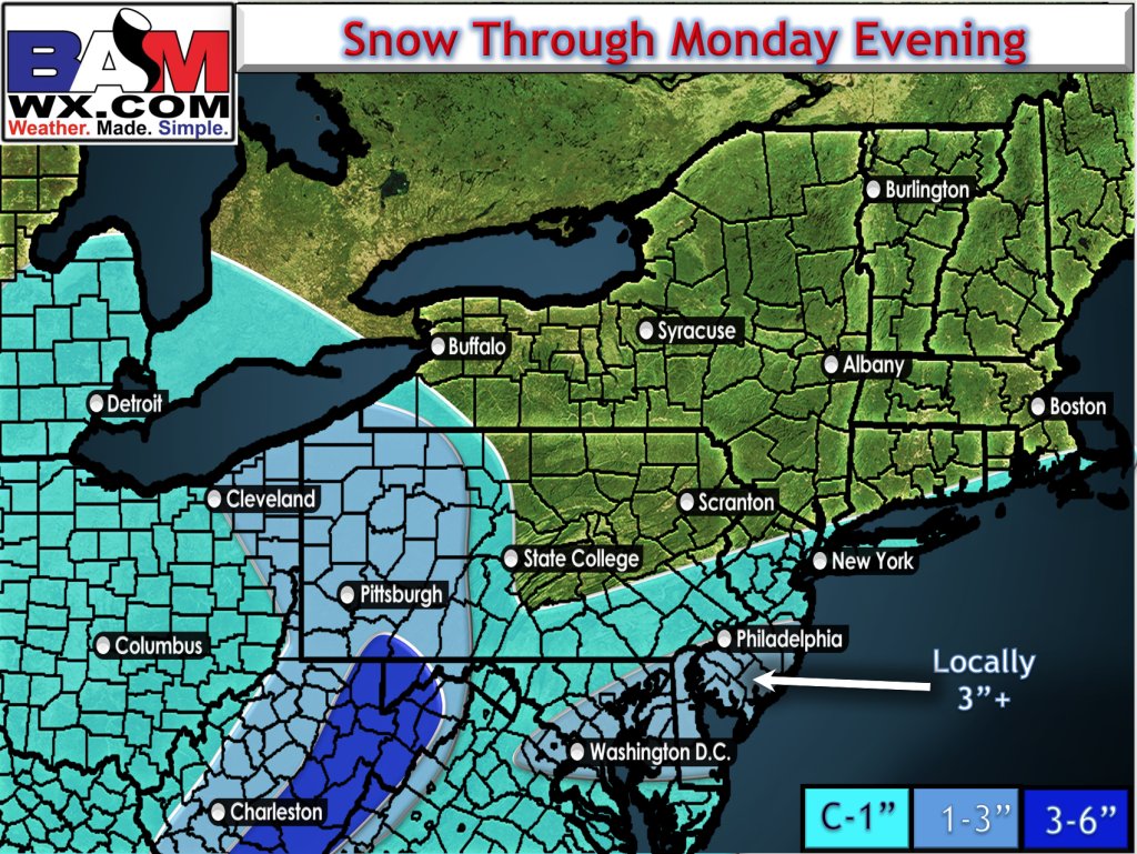
SNJ FTW - with dynamics Ocean, Atlantic and Cape MAy can easily see 3" plus

_________________
Mugs
AKA:King: Snow Weenie
Self Proclaimed
WINTER 2014-15 : 55.12" +.02 for 6 coatings (avg. 35")
WINTER 2015-16 Total - 29.8" (Avg 35")
WINTER 2016-17 : 39.5" so far

amugs- Advanced Forecaster - Mod

- Posts : 15147
Reputation : 213
Join date : 2013-01-07
Age : 54
Location : Hillsdale,NJ
 Re: January 2017 Observations & Discussions
amugs wrote:SNJ FTW - with dynamics Ocean, Atlantic and Cape MAy can easily see 3" plus
Anyone north of NYC, keep the line moving folks nothing to see here.

CPcantmeasuresnow- Wx Statistician Guru

- Posts : 7281
Reputation : 230
Join date : 2013-01-07
Age : 103
Location : Eastern Orange County, NY
 Re: January 2017 Observations & Discussions
Yep, that's WAY south, but some of our posters here will have a nice surprise tomorrow morning.My buddy in Atco NJ, halfway between Philly and AC should do well.
40.2, 45%, 29.38 R. Partly cloudy, calm.
40.2, 45%, 29.38 R. Partly cloudy, calm.

docstox12- Wx Statistician Guru

- Posts : 8610
Reputation : 222
Join date : 2013-01-07
Age : 74
Location : Monroe NY
 Re: January 2017 Observations & Discussions
docstox12 wrote:Yep, that's WAY south, but some of our posters here will have a nice surprise tomorrow morning.My buddy in Atco NJ, halfway between Philly and AC should do well.
40.2, 45%, 29.38 R. Partly cloudy, calm.
Hey doc I use to go out their back when I was in my 20s for the drag track . Great Memories

skinsfan1177- Senior Enthusiast

- Posts : 4485
Reputation : 35
Join date : 2013-01-07
Age : 47
Location : Point Pleasant Boro
 Re: January 2017 Observations & Discussions
I'm just barely in the northern fringe of that shading aound ny. Close call for some flakes or nada

jmanley32- Senior Enthusiast

- Posts : 20645
Reputation : 108
Join date : 2013-12-12
Age : 43
Location : Yonkers, NY
 Re: January 2017 Observations & Discussions
RGEM trended N by about 50 miles and GEFS has snow into the LHV, showing the LP stronger and a NNE movement


_________________
Mugs
AKA:King: Snow Weenie
Self Proclaimed
WINTER 2014-15 : 55.12" +.02 for 6 coatings (avg. 35")
WINTER 2015-16 Total - 29.8" (Avg 35")
WINTER 2016-17 : 39.5" so far

amugs- Advanced Forecaster - Mod

- Posts : 15147
Reputation : 213
Join date : 2013-01-07
Age : 54
Location : Hillsdale,NJ
 Re: January 2017 Observations & Discussions
amugs wrote:RGEM trended N by about 50 miles and GEFS has snow into the LHV, showing the LP stronger and a NNE movement
wow mugs so what are we looking at 2-4 area wide sounds good

skinsfan1177- Senior Enthusiast

- Posts : 4485
Reputation : 35
Join date : 2013-01-07
Age : 47
Location : Point Pleasant Boro
 Re: January 2017 Observations & Discussions
amugs wrote:RGEM trended N by about 50 miles and GEFS has snow into the LHV, showing the LP stronger and a NNE movement
hey mugs...if this were to happen and does effect my area..what time are we looking for this to start?

weatherwatchermom- Senior Enthusiast

- Posts : 3892
Reputation : 78
Join date : 2014-11-25
Location : Hazlet Township, NJ
 Re: January 2017 Observations & Discussions
NWS has me in a HWO, expecting light snow up here...
_________________
Janet
Snowfall winter of 2023-2024 17.5"
Snowfall winter of 2022-2023 6.0"
Snowfall winter of 2021-2022 17.6" 1" sleet 2/25/22
Snowfall winter of 2020-2021 51.1"
Snowfall winter of 2019-2020 8.5"
Snowfall winter of 2018-2019 25.1"
Snowfall winter of 2017-2018 51.9"
Snowfall winter of 2016-2017 45.6"
Snowfall winter of 2015-2016 29.5"
Snowfall winter of 2014-2015 50.55"
Snowfall winter of 2013-2014 66.5"
Dunnzoo- Senior Enthusiast - Mod

- Posts : 4934
Reputation : 68
Join date : 2013-01-11
Age : 62
Location : Westwood, NJ
 Re: January 2017 Observations & Discussions
Wondering if the area of snow and rain on the radar extending from over the Susquehanna Valley in south central PA down to the Baltimore MD area currently heading northeast will bring us a period of snow later tonight.

billg315- Advanced Forecaster - Mod

- Posts : 4554
Reputation : 185
Join date : 2015-01-24
Age : 50
Location : Flemington, NJ
 Re: January 2017 Observations & Discussions
Skins what are you thinking for our area ?
track17- Posts : 454
Reputation : 4
Join date : 2016-01-09
 Re: January 2017 Observations & Discussions
track17 wrote:Skins what are you thinking for our area ?
I think 2-4 inches area wide is a safe bet. Depending if the low explodes off the coast.

skinsfan1177- Senior Enthusiast

- Posts : 4485
Reputation : 35
Join date : 2013-01-07
Age : 47
Location : Point Pleasant Boro
track17- Posts : 454
Reputation : 4
Join date : 2016-01-09
 Re: January 2017 Observations & Discussions
what time frame are we looking at...sorry I am asking againskinsfan1177 wrote:track17 wrote:Skins what are you thinking for our area ?
I think 2-4 inches area wide is a safe bet. Depending if the low explodes off the coast.

weatherwatchermom- Senior Enthusiast

- Posts : 3892
Reputation : 78
Join date : 2014-11-25
Location : Hazlet Township, NJ
 Re: January 2017 Observations & Discussions
weatherwatchermom wrote:what time frame are we looking at...sorry I am asking againskinsfan1177 wrote:track17 wrote:Skins what are you thinking for our area ?
I think 2-4 inches area wide is a safe bet. Depending if the low explodes off the coast.
Sorry Joanne, start time just before school drop-off!
_________________
Janet
Snowfall winter of 2023-2024 17.5"
Snowfall winter of 2022-2023 6.0"
Snowfall winter of 2021-2022 17.6" 1" sleet 2/25/22
Snowfall winter of 2020-2021 51.1"
Snowfall winter of 2019-2020 8.5"
Snowfall winter of 2018-2019 25.1"
Snowfall winter of 2017-2018 51.9"
Snowfall winter of 2016-2017 45.6"
Snowfall winter of 2015-2016 29.5"
Snowfall winter of 2014-2015 50.55"
Snowfall winter of 2013-2014 66.5"

Dunnzoo- Senior Enthusiast - Mod

- Posts : 4934
Reputation : 68
Join date : 2013-01-11
Age : 62
Location : Westwood, NJ
 Re: January 2017 Observations & Discussions
Dunnzoo wrote:weatherwatchermom wrote:what time frame are we looking at...sorry I am asking againskinsfan1177 wrote:track17 wrote:Skins what are you thinking for our area ?
I think 2-4 inches area wide is a safe bet. Depending if the low explodes off the coast.
Sorry Joanne, start time just before school drop-off!
thanks Janet was curious..you know what I was hoping for...

weatherwatchermom- Senior Enthusiast

- Posts : 3892
Reputation : 78
Join date : 2014-11-25
Location : Hazlet Township, NJ
 Re: January 2017 Observations & Discussions
Nam is coming south with the second clipper.

nutleyblizzard- Senior Enthusiast

- Posts : 1963
Reputation : 41
Join date : 2014-01-30
Age : 58
Location : Nutley, new jersey
 Re: January 2017 Observations & Discussions
When is the 2nd clipper
track17- Posts : 454
Reputation : 4
Join date : 2016-01-09
 Re: January 2017 Observations & Discussions
nutleyblizzard wrote:Nam is coming south with the second clipper.
is that the one for tues afternoon?

weatherwatchermom- Senior Enthusiast

- Posts : 3892
Reputation : 78
Join date : 2014-11-25
Location : Hazlet Township, NJ
 Re: January 2017 Observations & Discussions
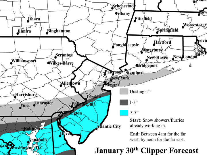
Here's my forecast for the clipper, for those interested:
Admittedly, the 3-5" zone may be better served as a 2-4", but I have some reasoning behind it. Although this is a clipper, which usually means the system won't be good for much more than an inch or two, it is moving into a more favorable spot. As it approaches our region, it does phase in some additional mid-level energy which is clearly shown to amplify the mid-level energy and differential potential vorticity advection (forcing for ascent). While there is no jet help to really fuel this system, the lower levels do provide some additional simultaneous support. Based on the season's tendency to develop systems shortly prior to reaching the coastline, likely due to the warmer than normal coastal waters, I am sticking with that trend here. Therefore, not only will there be a closed surface low pressure that develops prior to reaching the coast, but because there is a phase at H5, this should also allow the lower levels to close off in rather quick succession (H925 and then H850). As a direct result, this should work to quickly, although relatively briefly, enhance the low-level frontogenetical forcing for ascent. Third, there also appears to be a mild signature of H700 frontogenesis developing as a result of the lower levels closing off, thus changing the thermal gradient orientation to a more warm air advective profile and providing further forcing for ascent through this layer. With H5 energy and differential positive vorticity advection quickly increasing thanks to the phase, a band of moderate precipitation should develop just on the northwestern side of the lower level lows as the system swings through. One last thing to consider, is once the lower levels close off, this should also aid in increasing moisture fluxes off the Atlantic some, and wiith thermal profiles and saturation vapor pressures appearing to be conducive for plate snow crystal habits, accumulations should occur fairly efficiently through most of the window of moderate precipitation. Assuming ratios of 15:1 at minimum, with more likely 18:1, I do feel 3" should be achievable, with a few spots eclipsing 4". We'll see!!
Admittedly, the 3-5" zone may be better served as a 2-4", but I have some reasoning behind it. Although this is a clipper, which usually means the system won't be good for much more than an inch or two, it is moving into a more favorable spot. As it approaches our region, it does phase in some additional mid-level energy which is clearly shown to amplify the mid-level energy and differential potential vorticity advection (forcing for ascent). While there is no jet help to really fuel this system, the lower levels do provide some additional simultaneous support. Based on the season's tendency to develop systems shortly prior to reaching the coastline, likely due to the warmer than normal coastal waters, I am sticking with that trend here. Therefore, not only will there be a closed surface low pressure that develops prior to reaching the coast, but because there is a phase at H5, this should also allow the lower levels to close off in rather quick succession (H925 and then H850). As a direct result, this should work to quickly, although relatively briefly, enhance the low-level frontogenetical forcing for ascent. Third, there also appears to be a mild signature of H700 frontogenesis developing as a result of the lower levels closing off, thus changing the thermal gradient orientation to a more warm air advective profile and providing further forcing for ascent through this layer. With H5 energy and differential positive vorticity advection quickly increasing thanks to the phase, a band of moderate precipitation should develop just on the northwestern side of the lower level lows as the system swings through. One last thing to consider, is once the lower levels close off, this should also aid in increasing moisture fluxes off the Atlantic some, and wiith thermal profiles and saturation vapor pressures appearing to be conducive for plate snow crystal habits, accumulations should occur fairly efficiently through most of the window of moderate precipitation. Assuming ratios of 15:1 at minimum, with more likely 18:1, I do feel 3" should be achievable, with a few spots eclipsing 4". We'll see!!

rb924119- Meteorologist

- Posts : 7093
Reputation : 195
Join date : 2013-02-06
Age : 32
Location : Greentown, Pa
 Re: January 2017 Observations & Discussions
Yes.weatherwatchermom wrote:nutleyblizzard wrote:Nam is coming south with the second clipper.
is that the one for tues afternoon?

nutleyblizzard- Senior Enthusiast

- Posts : 1963
Reputation : 41
Join date : 2014-01-30
Age : 58
Location : Nutley, new jersey
 Re: January 2017 Observations & Discussions
nutleyblizzard wrote:Yes.weatherwatchermom wrote:nutleyblizzard wrote:Nam is coming south with the second clipper.
is that the one for tues afternoon?
thank you

weatherwatchermom- Senior Enthusiast

- Posts : 3892
Reputation : 78
Join date : 2014-11-25
Location : Hazlet Township, NJ
 Re: January 2017 Observations & Discussions
Started a thread for Tuesdays clipper. Tomorrow's event we can keep observations in this thread. Ray, nice writeup.
_________________
_______________________________________________________________________________________________________
CLICK HERE to view NJ Strong Snowstorm Classifications
 Re: January 2017 Observations & Discussions
Frank_Wx wrote:Started a thread for Tuesdays clipper. Tomorrow's event we can keep observations in this thread. Ray, nice writeup.
Thank you, sir! Now hopefully it verifies
rb924119- Meteorologist

- Posts : 7093
Reputation : 195
Join date : 2013-02-06
Age : 32
Location : Greentown, Pa
 Re: January 2017 Observations & Discussions
Good post Ray. I'll preface this next comment with the fact that I am expecting zero snow out of this but......how can your map have a 3-5" line that if extended offshore of NJ should include the eastern half and south shore of LI but instead all of LI is c-1"? Just curious. Thanks
Guest- Guest
Page 12 of 13 •  1, 2, 3 ... , 11, 12, 13
Page 12 of 13
Permissions in this forum:
You cannot reply to topics in this forum
 Home
Home
