Watching November 9th to 12th - First Snow?
+22
Vinnydula
dkodgis
Dunnzoo
billg315
nutleyblizzard
Wheezer
Sanchize06
heehaw453
rb924119
Snow88
weatherwatchermom
sroc4
CPcantmeasuresnow
skinsfan1177
frank 638
docstox12
Math23x7
aiannone
algae888
jmanley32
amugs
Frank_Wx
26 posters
Page 2 of 5 •  1, 2, 3, 4, 5
 Re: Watching November 9th to 12th - First Snow?
Oh boy gfs is now on board with cmc and euro for next Tues. Still 7 days out but liking we have snow to track. It is a big concern to see double digit snow with leaves still on some trees luckily all these winds have taken most down.
just saw 00z euro ,i t was close but not much of a storm compared to gfs and cmc. I do not think we will know much until the end of the weekend.
just saw 00z euro ,i t was close but not much of a storm compared to gfs and cmc. I do not think we will know much until the end of the weekend.
jmanley32- Senior Enthusiast

- Posts : 20642
Join date : 2013-12-12
 Re: Watching November 9th to 12th - First Snow?
jmanley32 wrote:Oh boy gfs is now on board with cmc and euro for next Tues. Still 7 days out but liking we have snow to track. It is a big concern to see double digit snow with leaves still on some trees luckily all these winds have taken most down.
just saw 00z euro ,i t was close but not much of a storm compared to gfs and cmc. I do not think we will know much until the end of the weekend.
Jman, good point on the leaves.
Up by me in the LHV, 90% of the leaves are down, but in mid Bergen County NJ, 60 or 70% of the trees still have leaves.That early october snowstorm we had 5 or 6 years ago resulted in widespread breaking of tree limbs everywhere aas a result of heavy,wet snow clinging to the remaining leaves.Another reason I don't like early heavy snow in October and November.I would prefer this possible snow next week to be in mid December.
docstox12- Wx Statistician Guru

- Posts : 8610
Join date : 2013-01-07
 Re: Watching November 9th to 12th - First Snow?
your losing track of time my friend lol 2011 nearly 9 years ago!! It was bad here too lost power for 2 days. My parents in ct even worse as it was after Irene and she hit CT worse than ny.docstox12 wrote:jmanley32 wrote:Oh boy gfs is now on board with cmc and euro for next Tues. Still 7 days out but liking we have snow to track. It is a big concern to see double digit snow with leaves still on some trees luckily all these winds have taken most down.
just saw 00z euro ,i t was close but not much of a storm compared to gfs and cmc. I do not think we will know much until the end of the weekend.
Jman, good point on the leaves.
Up by me in the LHV, 90% of the leaves are down, but in mid Bergen County NJ, 60 or 70% of the trees still have leaves.That early october snowstorm we had 5 or 6 years ago resulted in widespread breaking of tree limbs everywhere aas a result of heavy,wet snow clinging to the remaining leaves.Another reason I don't like early heavy snow in October and November.I would prefer this possible snow next week to be in mid December.

jmanley32- Senior Enthusiast

- Posts : 20642
Reputation : 108
Join date : 2013-12-12
Age : 43
Location : Yonkers, NY
 Re: Watching November 9th to 12th - First Snow?
Same here as much I love snow I Rather see this in December and January not now especially we still have leaves on the trees and I thing we need is power outages so I hope we don’t have any snow for next week last thing we need is a lousy winter again
frank 638- Senior Enthusiast

- Posts : 2877
Reputation : 37
Join date : 2016-01-01
Age : 41
Location : bronx ny
 Re: Watching November 9th to 12th - First Snow?
Most of the major models like Tuesday. Bonus is that cold air is locked in prior to the storm. We just need the moisture.
_________________
-Alex Iannone-

aiannone- Senior Enthusiast - Mod

- Posts : 4826
Reputation : 92
Join date : 2013-01-07
Location : Saint James, LI (Northwest Suffolk Co.)
 Re: Watching November 9th to 12th - First Snow?
I'm all in for a big storm next week there aren't so many leaves left that it'll be a huge deal and early snow has just been a coincidence to a bad winter . unless someone can tell me scientifically how a early snow storm alters the following 3 to 4 months.

jmanley32- Senior Enthusiast

- Posts : 20642
Reputation : 108
Join date : 2013-12-12
Age : 43
Location : Yonkers, NY
 Re: Watching November 9th to 12th - First Snow?
yeah euro is back and forth from big storm to little but now gfs shows a big storm and cmc has been showing a all out blizzard so let's wait and see what happens. At the end of euro and cmc run another coastal spins up. I have a feeling go be a busy winter. I just hope not too many snow days cuz I only get 2 at my school then they take from our February break.aiannone wrote:Most of the major models like Tuesday. Bonus is that cold air is locked in prior to the storm. We just need the moisture.

jmanley32- Senior Enthusiast

- Posts : 20642
Reputation : 108
Join date : 2013-12-12
Age : 43
Location : Yonkers, NY
 Re: Watching November 9th to 12th - First Snow?
jmanley32 wrote:your losing track of time my friend lol 2011 nearly 9 years ago!! It was bad here too lost power for 2 days. My parents in ct even worse as it was after Irene and she hit CT worse than ny.docstox12 wrote:jmanley32 wrote:Oh boy gfs is now on board with cmc and euro for next Tues. Still 7 days out but liking we have snow to track. It is a big concern to see double digit snow with leaves still on some trees luckily all these winds have taken most down.
just saw 00z euro ,i t was close but not much of a storm compared to gfs and cmc. I do not think we will know much until the end of the weekend.
Jman, good point on the leaves.
Up by me in the LHV, 90% of the leaves are down, but in mid Bergen County NJ, 60 or 70% of the trees still have leaves.That early october snowstorm we had 5 or 6 years ago resulted in widespread breaking of tree limbs everywhere aas a result of heavy,wet snow clinging to the remaining leaves.Another reason I don't like early heavy snow in October and November.I would prefer this possible snow next week to be in mid December.
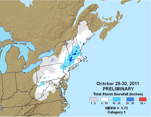
I'm Not sure if you meant Irene was worse in CT or the October snowstorm was worse but clearly the snowstorm impacted the HV of NY far worse then most of eastern and coastal CT. In Orange County we had 16 inches from that storm and 20 miles to the west in West Milford NJ they had 19 inches.

CPcantmeasuresnow- Wx Statistician Guru

- Posts : 7281
Reputation : 230
Join date : 2013-01-07
Age : 103
Location : Eastern Orange County, NY
 Re: Watching November 9th to 12th - First Snow?
jmanley32 wrote:your losing track of time my friend lol 2011 nearly 9 years ago!! It was bad here too lost power for 2 days. My parents in ct even worse as it was after Irene and she hit CT worse than ny.docstox12 wrote:jmanley32 wrote:Oh boy gfs is now on board with cmc and euro for next Tues. Still 7 days out but liking we have snow to track. It is a big concern to see double digit snow with leaves still on some trees luckily all these winds have taken most down.
just saw 00z euro ,i t was close but not much of a storm compared to gfs and cmc. I do not think we will know much until the end of the weekend.
Jman, good point on the leaves.
Up by me in the LHV, 90% of the leaves are down, but in mid Bergen County NJ, 60 or 70% of the trees still have leaves.That early october snowstorm we had 5 or 6 years ago resulted in widespread breaking of tree limbs everywhere aas a result of heavy,wet snow clinging to the remaining leaves.Another reason I don't like early heavy snow in October and November.I would prefer this possible snow next week to be in mid December.
LOL, jman, see what happens when you are nearly 70!

docstox12- Wx Statistician Guru

- Posts : 8610
Reputation : 222
Join date : 2013-01-07
Age : 74
Location : Monroe NY
 Re: Watching November 9th to 12th - First Snow?
A lot is going on with the pattern over the next few days and it's possible a storm threat next Tuesday brings our first widespread snowfall. Models are showing an impressive ridge developing over the EPO/PNA regions this weekend. Show by the GEFS valid for this Saturday:

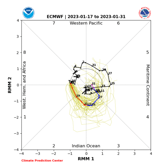
The MJO is currently in a moderate amplitude phase 5 location. It is expected to progress toward phases 6-7-8 over the next 10 days. As this wave moves into the western Pacific it will generate enough upward motion in the atmosphere to promote rising upper level heights across the northern Pacific. Historically, this is what a moderately amplified phase 7, which is where it is forecasted to go, looks like in terms of 500mb heights:

If you compare that image to the one I posted of the GEFS, the location of the warmer than normal heights is almost identical but the intensity of the ridge differs. Another entity that is potentially over-amplifying the ridging across the Pacific is the cut-off ULL (upper level low) over Baja. Check it out on the EURO...this image is valid for Sunday night:

Man, that is quite the ridge! What happens downstream will determine the outcome of Tuesday's storm. One can argue the axis of the western ridge is displaced too far west, or is oriented unfavorably for an east coast storm to amplify in an ideal location that would promote a wintry solution. This may be true, but it could be helped by the location of a 50-50 low over SE Canada.

The NAO region is not completely barred of positive height anomalies either. If the backdoor blocking over that region strengthens it could force the 50-50 Low further south and act as the block we need for this storm system. Regardless, the power of the western ridges will do their best to consolidate upper level energy into the trough that would develop a robust low pressure system. Where it tracks remains unknown, but the threat is definitely there for our first snowfall of the season.


The MJO is currently in a moderate amplitude phase 5 location. It is expected to progress toward phases 6-7-8 over the next 10 days. As this wave moves into the western Pacific it will generate enough upward motion in the atmosphere to promote rising upper level heights across the northern Pacific. Historically, this is what a moderately amplified phase 7, which is where it is forecasted to go, looks like in terms of 500mb heights:

If you compare that image to the one I posted of the GEFS, the location of the warmer than normal heights is almost identical but the intensity of the ridge differs. Another entity that is potentially over-amplifying the ridging across the Pacific is the cut-off ULL (upper level low) over Baja. Check it out on the EURO...this image is valid for Sunday night:

Man, that is quite the ridge! What happens downstream will determine the outcome of Tuesday's storm. One can argue the axis of the western ridge is displaced too far west, or is oriented unfavorably for an east coast storm to amplify in an ideal location that would promote a wintry solution. This may be true, but it could be helped by the location of a 50-50 low over SE Canada.

The NAO region is not completely barred of positive height anomalies either. If the backdoor blocking over that region strengthens it could force the 50-50 Low further south and act as the block we need for this storm system. Regardless, the power of the western ridges will do their best to consolidate upper level energy into the trough that would develop a robust low pressure system. Where it tracks remains unknown, but the threat is definitely there for our first snowfall of the season.
_________________
_______________________________________________________________________________________________________
CLICK HERE to view NJ Strong Snowstorm Classifications
 Re: Watching November 9th to 12th - First Snow?
Theirs also a kicker showing up for tuesdays storm and it looks potent

skinsfan1177- Senior Enthusiast

- Posts : 4485
Reputation : 35
Join date : 2013-01-07
Age : 47
Location : Point Pleasant Boro
 Re: Watching November 9th to 12th - First Snow?
7days out guys. Waaaaay ahead of ourselves analyzing the individual pieces of energy and posting about snow maps and such on operational models. Pattern recognition first. Need the weekend at the earliest to really start analyzing any details on the operational models.
_________________
"In weather and in life, there's no winning and losing; there's only winning and learning."
WINTER 2012/2013 TOTALS 43.65"WINTER 2017/2018 TOTALS 62.85" WINTER 2022/2023 TOTALS 4.9"
WINTER 2013/2014 TOTALS 64.85"WINTER 2018/2019 TOTALS 14.25" WINTER 2023/2024 TOTALS 13.1"
WINTER 2014/2015 TOTALS 71.20"WINTER 2019/2020 TOTALS 6.35" WINTER 2024/2025 TOTALS 0.00
WINTER 2015/2016 TOTALS 35.00"WINTER 2020/2021 TOTALS 37.75"
WINTER 2016/2017 TOTALS 42.25"WINTER 2021/2022 TOTALS 31.65"

sroc4- Admin

- Posts : 8458
Reputation : 302
Join date : 2013-01-07
Location : Wading River, LI
 Re: Watching November 9th to 12th - First Snow?
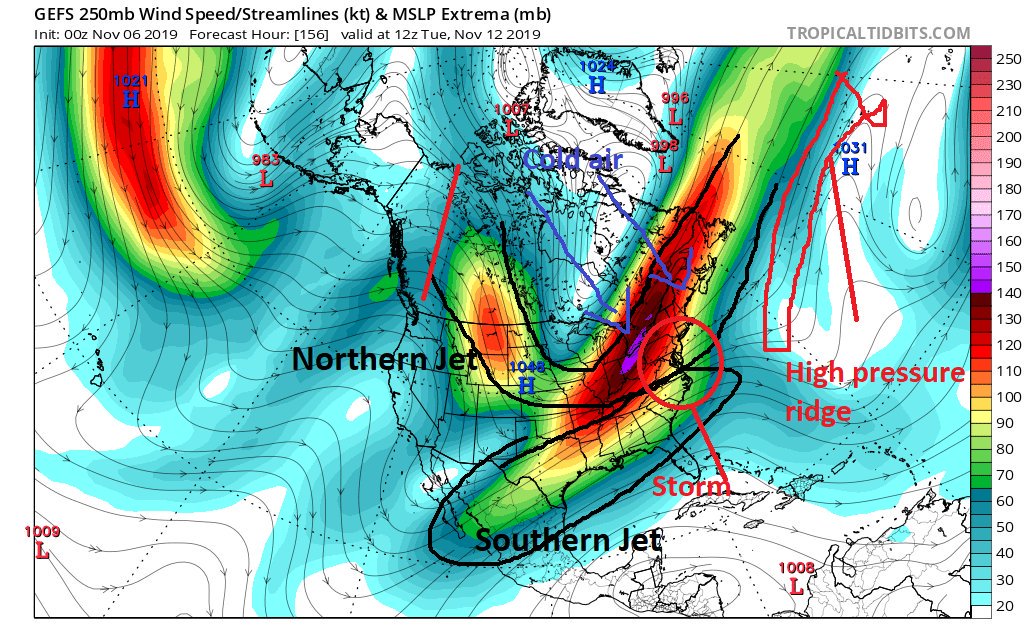
Here are the players

_________________
Mugs
AKA:King: Snow Weenie
Self Proclaimed
WINTER 2014-15 : 55.12" +.02 for 6 coatings (avg. 35")
WINTER 2015-16 Total - 29.8" (Avg 35")
WINTER 2016-17 : 39.5" so far

amugs- Advanced Forecaster - Mod

- Posts : 15143
Reputation : 213
Join date : 2013-01-07
Age : 54
Location : Hillsdale,NJ
 Re: Watching November 9th to 12th - First Snow?
sroc4 wrote:7days out guys. Waaaaay ahead of ourselves analyzing the individual pieces of energy and posting about snow maps and such on operational models. Pattern recognition first. Need the weekend at the earliest to really start analyzing any details on the operational models.
ha ha thought to myself where is Sroc....to tell us this...tempered excitement...but no expectations!! but let the TRACKING BEGIN!!

weatherwatchermom- Senior Enthusiast

- Posts : 3891
Reputation : 78
Join date : 2014-11-25
Location : Hazlet Township, NJ
 Re: Watching November 9th to 12th - First Snow?
amugs wrote:Here are the players
Thank you for the break down! Can't wait to see how this plays out..at least we have something to track...weather has been so boring for such a long time!

weatherwatchermom- Senior Enthusiast

- Posts : 3891
Reputation : 78
Join date : 2014-11-25
Location : Hazlet Township, NJ
 Re: Watching November 9th to 12th - First Snow?
GFS looks good even for the coast

Snow88- Senior Enthusiast

- Posts : 2193
Reputation : 4
Join date : 2013-01-09
Age : 36
Location : Brooklyn, NY
 Re: Watching November 9th to 12th - First Snow?
I don't think anyone will have a issue with cold. That will be in place but stickage being we won't have been cold for long will be hard at least at the start. It's going to have to snow hard on coast to get Sig accumulation. There's a map of snow depth which I assume means what actually sticks and it's far less about half if not more.Snow88 wrote:GFS looks good even for the coast

jmanley32- Senior Enthusiast

- Posts : 20642
Reputation : 108
Join date : 2013-12-12
Age : 43
Location : Yonkers, NY
 Re: Watching November 9th to 12th - First Snow?
Anyone take a gander at the cold next week - Jesus its January Polar Vortex type cold. If it were January with these temps Louis Cifer himself would be crying UNCLE!!!


_________________
Mugs
AKA:King: Snow Weenie
Self Proclaimed
WINTER 2014-15 : 55.12" +.02 for 6 coatings (avg. 35")
WINTER 2015-16 Total - 29.8" (Avg 35")
WINTER 2016-17 : 39.5" so far

amugs- Advanced Forecaster - Mod

- Posts : 15143
Reputation : 213
Join date : 2013-01-07
Age : 54
Location : Hillsdale,NJ
 Re: Watching November 9th to 12th - First Snow?
Yes, mugsy, Lee Goldberg last night mentioned we would have January cold in November also.

docstox12- Wx Statistician Guru

- Posts : 8610
Reputation : 222
Join date : 2013-01-07
Age : 74
Location : Monroe NY
 Re: Watching November 9th to 12th - First Snow?
amugs wrote:Anyone take a gander at the cold next week - Jesus its January Polar Vortex type cold. If it were January with these temps Louis Cifer himself would be crying UNCLE!!!
Jesus, near single digits even to the coast?! thats insame even for january. Yikes, not gonna have any issues snowing and sticking if these temps are true and we get a storm.

jmanley32- Senior Enthusiast

- Posts : 20642
Reputation : 108
Join date : 2013-12-12
Age : 43
Location : Yonkers, NY
 Re: Watching November 9th to 12th - First Snow?
Regarding next week threat:
“Just my .02 here, based on very coarse and quick peeks, but I my early incling is that’s this will end up as either an I-95 special or a coastal scraper. Reasons being are the following, and they include the ideas presented heretofore by @33andrain, @CCB!, @Allsnow, @Armando S, and @PB GFI. There is an overwhelming number of factors that I like to look at when trying diagnose the most likely storm track/evolution, as those of you who have read my thoughts regularly last winter will probably remember. In this case, we would have the following: 70N/70E ridge, -EPO, -WPO, +PNA triplet, favorable downturn of >1°C in Niño 1.2 at an appropriate lead time of 2-3 weeks, AND favorable downturn in the SOI at an appropriate lead time of 5-7 days. These are only counterveiled by positive SST anomalies in the Western Atlantic/Gulf, MJO entering P6-7, and lack of a -NAO. Therefore, there is a clear bias towards an overall significantly colder/suppressed evolution.
However, the positioning of the Western North American ridge axis is a bit far back, and so will work to shift the storm track given the general wavelengths. That being said, the restructuring of this ridge is important because as it restructures, a piece folds over into the prime-time region with a (what I’ll call) a pseudo axis over Boise, Idaho. That should prevent a coastal hugger/inland runner scenario in conjunction with the other indices. As Geoff said, I am concerned with a miss wide-right, but I think the initial ridge axis placement saves us from that, while the restructuring of it and the other indices lead to a favorable evolution for the coastal plain in the long run. If I have time, I’d like to dig deeper, but that’s what I saw in approximately five minutes lol”
rb924119- Meteorologist

- Posts : 7088
Reputation : 195
Join date : 2013-02-06
Age : 32
Location : Greentown, Pa
 Re: Watching November 9th to 12th - First Snow?
So what I got from this was it will be a coastal snowstorm or nothing but you are leaning away from suppressed? Are those temps mugs posted even close to possible? Thats gotta be some kind of record at least for the coast. Do you think it could be a lot of snow or just a moderate snow? I could see how that severe cold could suppress though, wouldnt be the first stime we seen cold mess up our snow storms.rb924119 wrote:Regarding next week threat:
“Just my .02 here, based on very coarse and quick peeks, but I my early incling is that’s this will end up as either an I-95 special or a coastal scraper. Reasons being are the following, and they include the ideas presented heretofore by @33andrain, @CCB!, @Allsnow, @Armando S, and @PB GFI. There is an overwhelming number of factors that I like to look at when trying diagnose the most likely storm track/evolution, as those of you who have read my thoughts regularly last winter will probably remember. In this case, we would have the following: 70N/70E ridge, -EPO, -WPO, +PNA triplet, favorable downturn of >1°C in Niño 1.2 at an appropriate lead time of 2-3 weeks, AND favorable downturn in the SOI at an appropriate lead time of 5-7 days. These are only counterveiled by positive SST anomalies in the Western Atlantic/Gulf, MJO entering P6-7, and lack of a -NAO. Therefore, there is a clear bias towards an overall significantly colder/suppressed evolution.
However, the positioning of the Western North American ridge axis is a bit far back, and so will work to shift the storm track given the general wavelengths. That being said, the restructuring of this ridge is important because as it restructures, a piece folds over into the prime-time region with a (what I’ll call) a pseudo axis over Boise, Idaho. That should prevent a coastal hugger/inland runner scenario in conjunction with the other indices. As Geoff said, I am concerned with a miss wide-right, but I think the initial ridge axis placement saves us from that, while the restructuring of it and the other indices lead to a favorable evolution for the coastal plain in the long run. If I have time, I’d like to dig deeper, but that’s what I saw in approximately five minutes lol”

jmanley32- Senior Enthusiast

- Posts : 20642
Reputation : 108
Join date : 2013-12-12
Age : 43
Location : Yonkers, NY
 Re: Watching November 9th to 12th - First Snow?
Models went a little further west with the Tuesday storm. Therefore the snow is confined to NW of NYC
_________________
-Alex Iannone-

aiannone- Senior Enthusiast - Mod

- Posts : 4826
Reputation : 92
Join date : 2013-01-07
Location : Saint James, LI (Northwest Suffolk Co.)

skinsfan1177- Senior Enthusiast

- Posts : 4485
Reputation : 35
Join date : 2013-01-07
Age : 47
Location : Point Pleasant Boro
 Re: Watching November 9th to 12th - First Snow?
_________________
Mugs
AKA:King: Snow Weenie
Self Proclaimed
WINTER 2014-15 : 55.12" +.02 for 6 coatings (avg. 35")
WINTER 2015-16 Total - 29.8" (Avg 35")
WINTER 2016-17 : 39.5" so far

amugs- Advanced Forecaster - Mod

- Posts : 15143
Reputation : 213
Join date : 2013-01-07
Age : 54
Location : Hillsdale,NJ
 Re: Watching November 9th to 12th - First Snow?
Most models showing next Tuesday as progressive meaning a significant storm would be tough to form. I think c-1" for November would be nice.
heehaw453- Advanced Forecaster

- Posts : 3926
Reputation : 86
Join date : 2014-01-20
Location : Bedminster Township, PA Elevation 600' ASL
 Re: Watching November 9th to 12th - First Snow?
Most models are still sniffing this out nothing in stone 12z GFS was a nice hit Ukie looked good too.

skinsfan1177- Senior Enthusiast

- Posts : 4485
Reputation : 35
Join date : 2013-01-07
Age : 47
Location : Point Pleasant Boro
Page 2 of 5 •  1, 2, 3, 4, 5
Permissions in this forum:
You cannot reply to topics in this forum
 Home
Home

