
 Search
Dec 16-17 Snow/Ice potential storm
Page 3 of 11 •  1, 2, 3, 4 ... 9, 10, 11
 ![]()
Re: Dec 16-17 Snow/Ice potential storm
![]() by hyde345 Sun Dec 15, 2019 11:15 am
by hyde345 Sun Dec 15, 2019 11:15 am
jimv45 wrote:I am about an hour from Mike expecting mostly snow here in Saugerties. Hope no ice. Some of those ice predictions are scary to my south hope snow or rain for those folks.
Jim, you are likely to see sleet and ZR also especially on Tuesday as areas south of Albany will see some mixing. Hopefully you can get an inch or 2 of snow also in beginning and when low tracks east and precip turns back to snow. It's gonna be a mess for me.
hyde345- Pro Enthusiast

- Posts : 1082
Join date : 2013-01-08
Re: Dec 16-17 Snow/Ice potential storm
![]() by hyde345 Sun Dec 15, 2019 11:24 am
by hyde345 Sun Dec 15, 2019 11:24 am
hyde345- Pro Enthusiast
- Posts : 1082
Join date : 2013-01-08
Re: Dec 16-17 Snow/Ice potential storm
![]() by jimv45 Sun Dec 15, 2019 11:49 am
by jimv45 Sun Dec 15, 2019 11:49 am
jimv45- Senior Enthusiast

- Posts : 1168
Reputation : 36
Join date : 2013-09-20
Location : Hopewell jct.
Re: Dec 16-17 Snow/Ice potential storm
![]() by jmanley32 Sun Dec 15, 2019 12:23 pm
by jmanley32 Sun Dec 15, 2019 12:23 pm

jmanley32- Senior Enthusiast
- Posts : 20634
Reputation : 108
Join date : 2013-12-12
Age : 43
Location : Yonkers, NY
Re: Dec 16-17 Snow/Ice potential storm
![]() by heehaw453 Sun Dec 15, 2019 1:03 pm
by heehaw453 Sun Dec 15, 2019 1:03 pm
heehaw453- Advanced Forecaster

- Posts : 3906
Reputation : 86
Join date : 2014-01-20
Location : Bedminster Township, PA Elevation 600' ASL
Re: Dec 16-17 Snow/Ice potential storm
![]() by hyde345 Sun Dec 15, 2019 1:18 pm
by hyde345 Sun Dec 15, 2019 1:18 pm
heehaw453 wrote:I must say the Euro has handled this storm very poorly. The GFS has been steadfast saying non snow event for most. GFS never bought into the WAA the way the Euro did. Not the first time Euro has sold a false set of goods this year at close range.
True the GFS never had the waa modeled the way euro did but it did have low cutting to Great Lakes for days and has been inconsistent with the evolution as well. We will see how it plays out.

hyde345- Pro Enthusiast
- Posts : 1082
Reputation : 48
Join date : 2013-01-08
Location : Hyde Park, NY
Re: Dec 16-17 Snow/Ice potential storm
![]() by amugs Sun Dec 15, 2019 2:47 pm
by amugs Sun Dec 15, 2019 2:47 pm
heehaw453 wrote:I must say the Euro has handled this storm very poorly. The GFS has been steadfast saying non snow event for most. GFS never bought into the WAA the way the Euro did. Not the first time Euro has sold a false set of goods this year at close range.
For this it maybe right but he track was absolutely atrocious from a lakes cutter rainstorm - yeah that's gonna verify, to a Apps runner to a low that's get killed by the PA/WV border now. The EURO has been steadfast on a snow to ice to rain for the coast and a snow to ice event for inland since Wednesday. If I cold post the last 16 runs. of teh GFS evolution it would be comical.
It may not be what the EURO was showing at 0z or 12Z yesterday but it can be impact for a large swath of NNJ and LHV. This is concerning for Tuesday morning in NNJ
Lightish precip
Sub Freezing Temps I78 North
NYC Metro not a problem nor LI but above I 78 it could be really dicy and icy
The cold arctic push behind this is pretty intense for this time of the year
_________________
Mugs
AKA:King: Snow Weenie
Self Proclaimed
WINTER 2014-15 : 55.12" +.02 for 6 coatings (avg. 35")
WINTER 2015-16 Total - 29.8" (Avg 35")
WINTER 2016-17 : 39.5" so far

amugs- Advanced Forecaster - Mod

- Posts : 15127
Reputation : 213
Join date : 2013-01-07
Age : 54
Location : Hillsdale,NJ
Re: Dec 16-17 Snow/Ice potential storm
![]() by aiannone Sun Dec 15, 2019 3:14 pm
by aiannone Sun Dec 15, 2019 3:14 pm

_________________
-Alex Iannone-

aiannone- Senior Enthusiast - Mod
- Posts : 4822
Reputation : 92
Join date : 2013-01-07
Location : Saint James, LI (Northwest Suffolk Co.)
Re: Dec 16-17 Snow/Ice potential storm
![]() by heehaw453 Sun Dec 15, 2019 3:17 pm
by heehaw453 Sun Dec 15, 2019 3:17 pm
amugs wrote:heehaw453 wrote:I must say the Euro has handled this storm very poorly. The GFS has been steadfast saying non snow event for most. GFS never bought into the WAA the way the Euro did. Not the first time Euro has sold a false set of goods this year at close range.
For this it maybe right but he track was absolutely atrocious from a lakes cutter rainstorm - yeah that's gonna verify, to a Apps runner to a low that's get killed by the PA/WV border now. The EURO has been steadfast on a snow to ice to rain for the coast and a snow to ice event for inland since Wednesday. If I cold post the last 16 runs. of teh GFS evolution it would be comical.
It may not be what the EURO was showing at 0z or 12Z yesterday but it can be impact for a large swath of NNJ and LHV. This is concerning for Tuesday morning in NNJ
Lightish precip
Sub Freezing Temps I78 North
NYC Metro not a problem nor LI but above I 78 it could be really dicy and icy
The cold arctic push behind this is pretty intense for this time of the year
Fwiw euro had it cutting too on a few runs. It was never going to be an all snow event regardless of whether it cut or not.
4-6” on Saturday 0z from TTN to route 80. Now showing 1/2”. That is NAM like. Also did similar
thing with beginning of December storm albeit that was within 24 hours.
heehaw453- Advanced Forecaster
- Posts : 3906
Reputation : 86
Join date : 2014-01-20
Location : Bedminster Township, PA Elevation 600' ASL
Re: Dec 16-17 Snow/Ice potential storm
![]() by amugs Sun Dec 15, 2019 4:33 pm
by amugs Sun Dec 15, 2019 4:33 pm
Listen, I don't care if it showed 4" then 1",btw we are not seeing a 1/2" of snow N of I80 in NNJ, the fact being the euro lost the cutter idea on this said storm days ago whilst the GFS went from a lakes cutter to a apps runner to what it is now.
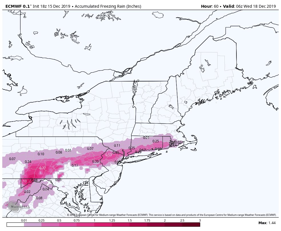
Has the Euro been stellar no not at all, but it started to see this evolution a hell of a lot earlier than the GFS. Also, the ice accretion though overdone to a degree will come to fruition over NNJ and the LHV and EPA.
Just got an alert from NWS on my phone for a WWA for up to 2" of snow and .20 of ice for my area in NNJ monday evening through 6pm Tuesday night.
As I posted the temps map, the CAD is going to be tough to scour if you put down a couple inches of snow meaning it will hang on longer.
Now cast time ahead.
New HRRR model.from Superstorm on 33&rain site

Last edited by amugs on Sun Dec 15, 2019 7:35 pm; edited 1 time in total
_________________
Mugs
AKA:King: Snow Weenie
Self Proclaimed
WINTER 2014-15 : 55.12" +.02 for 6 coatings (avg. 35")
WINTER 2015-16 Total - 29.8" (Avg 35")
WINTER 2016-17 : 39.5" so far
amugs- Advanced Forecaster - Mod
- Posts : 15127
Reputation : 213
Join date : 2013-01-07
Age : 54
Location : Hillsdale,NJ
Re: Dec 16-17 Snow/Ice potential storm
![]() by heehaw453 Sun Dec 15, 2019 5:39 pm
by heehaw453 Sun Dec 15, 2019 5:39 pm
heehaw453- Advanced Forecaster
- Posts : 3906
Reputation : 86
Join date : 2014-01-20
Location : Bedminster Township, PA Elevation 600' ASL
Re: Dec 16-17 Snow/Ice potential storm
![]() by billg315 Sun Dec 15, 2019 5:52 pm
by billg315 Sun Dec 15, 2019 5:52 pm

billg315- Advanced Forecaster - Mod
- Posts : 4530
Reputation : 185
Join date : 2015-01-24
Age : 50
Location : Flemington, NJ
Re: Dec 16-17 Snow/Ice potential storm
![]() by jmanley32 Sun Dec 15, 2019 5:53 pm
by jmanley32 Sun Dec 15, 2019 5:53 pm
Greeat thats about white plains NY where I work. Is this still tomorrow or tuesday?heehaw453 wrote:If the mesoscale models are right. 20 miles to nw of 95 should prepare for an ice storm. Especially RGEM.
jmanley32- Senior Enthusiast
- Posts : 20634
Reputation : 108
Join date : 2013-12-12
Age : 43
Location : Yonkers, NY
Re: Dec 16-17 Snow/Ice potential storm
![]() by jmanley32 Sun Dec 15, 2019 6:01 pm
by jmanley32 Sun Dec 15, 2019 6:01 pm
jmanley32- Senior Enthusiast
- Posts : 20634
Reputation : 108
Join date : 2013-12-12
Age : 43
Location : Yonkers, NY
Re: Dec 16-17 Snow/Ice potential storm
![]() by jmanley32 Sun Dec 15, 2019 6:03 pm
by jmanley32 Sun Dec 15, 2019 6:03 pm

jmanley32- Senior Enthusiast
- Posts : 20634
Reputation : 108
Join date : 2013-12-12
Age : 43
Location : Yonkers, NY
Re: Dec 16-17 Snow/Ice potential storm
![]() by heehaw453 Sun Dec 15, 2019 6:04 pm
by heehaw453 Sun Dec 15, 2019 6:04 pm
If rgem is right this will be 1/3-1/2+” ice accretion. Hopefully mesos are wrong.
heehaw453- Advanced Forecaster
- Posts : 3906
Reputation : 86
Join date : 2014-01-20
Location : Bedminster Township, PA Elevation 600' ASL
Re: Dec 16-17 Snow/Ice potential storm
![]() by jmanley32 Sun Dec 15, 2019 6:08 pm
by jmanley32 Sun Dec 15, 2019 6:08 pm
This is gonna be 100% nowcast IMO, where the icing sets up, how long it persists. rgem has over a inch in some areas of PA and NJ, thats horrific.heehaw453 wrote:Meso models showing NE winds. That’s kiss of death for CAD and ice storm. NAO and weak storm allow slp to cut underneath.
If rgem is right this will be 1/3-1/2+” ice accretion. Hopefully mesos are wrong.
jmanley32- Senior Enthusiast
- Posts : 20634
Reputation : 108
Join date : 2013-12-12
Age : 43
Location : Yonkers, NY
Re: Dec 16-17 Snow/Ice potential storm
![]() by bobjohnsonforthehall Sun Dec 15, 2019 6:43 pm
by bobjohnsonforthehall Sun Dec 15, 2019 6:43 pm

bobjohnsonforthehall- Posts : 311
Reputation : 19
Join date : 2016-10-02
Location : Flemington NJ
Re: Dec 16-17 Snow/Ice potential storm
![]() by jmanley32 Sun Dec 15, 2019 6:53 pm
by jmanley32 Sun Dec 15, 2019 6:53 pm
Dear Lord!! I find it hard to believe the city sees that much but just outside and certainly inland, but omg highest 2.23 inches!!! Thats crippling as mugs would put it. Even 0.76 as it shows around city is terrible, this all looks to come during the day tuesday too, not so much monday into tueesday morning.bobjohnsonforthehall wrote:HRDPS better be on crack. Egads.

jmanley32- Senior Enthusiast
- Posts : 20634
Reputation : 108
Join date : 2013-12-12
Age : 43
Location : Yonkers, NY
Re: Dec 16-17 Snow/Ice potential storm
![]() by hyde345 Sun Dec 15, 2019 7:13 pm
by hyde345 Sun Dec 15, 2019 7:13 pm
jmanley32 wrote:Dear Lord!! I find it hard to believe the city sees that much but just outside and certainly inland, but omg highest 2.23 inches!!! Thats crippling as mugs would put it. Even 0.76 as it shows around city is terrible, this all looks to come during the day tuesday too, not so much monday into tueesday morning.bobjohnsonforthehall wrote:HRDPS better be on crack. Egads.
Those amounts are a little ridiculous. 1/2 inch ice storms only happen about once every 10 years. I find it funny that this system has had a 1000 different solutions so far.
hyde345- Pro Enthusiast
- Posts : 1082
Reputation : 48
Join date : 2013-01-08
Location : Hyde Park, NY
Re: Dec 16-17 Snow/Ice potential storm
![]() by jmanley32 Sun Dec 15, 2019 7:15 pm
by jmanley32 Sun Dec 15, 2019 7:15 pm
If it is true everyone is going to be caught off guard. rgem is at its end range lets see what it shows tomorrow 12z.hyde345 wrote:jmanley32 wrote:Dear Lord!! I find it hard to believe the city sees that much but just outside and certainly inland, but omg highest 2.23 inches!!! Thats crippling as mugs would put it. Even 0.76 as it shows around city is terrible, this all looks to come during the day tuesday too, not so much monday into tueesday morning.bobjohnsonforthehall wrote:HRDPS better be on crack. Egads.
Those amounts are a little ridiculous. 1/2 inch ice storms only happen about once every 10 years. I find it funny that this system has had a 1000 different solutions so far.
jmanley32- Senior Enthusiast
- Posts : 20634
Reputation : 108
Join date : 2013-12-12
Age : 43
Location : Yonkers, NY
Re: Dec 16-17 Snow/Ice potential storm
![]() by amugs Sun Dec 15, 2019 7:39 pm
by amugs Sun Dec 15, 2019 7:39 pm
_________________
Mugs
AKA:King: Snow Weenie
Self Proclaimed
WINTER 2014-15 : 55.12" +.02 for 6 coatings (avg. 35")
WINTER 2015-16 Total - 29.8" (Avg 35")
WINTER 2016-17 : 39.5" so far
amugs- Advanced Forecaster - Mod
- Posts : 15127
Reputation : 213
Join date : 2013-01-07
Age : 54
Location : Hillsdale,NJ
Re: Dec 16-17 Snow/Ice potential storm
![]() by jmanley32 Sun Dec 15, 2019 7:43 pm
by jmanley32 Sun Dec 15, 2019 7:43 pm
LMAO good lord, that ice map on hi-res rgem has me getting 1.0-1.25 ice accretion thats really bad, Euro is back with ice again too about 0.25-0.5 for my area. Lordy this is going to catch people off guard in one way or another, timing does not even seem to be nailed down. Also timing doesnt look like anything starts until 03z Tuesday, thats way off from tomorrow afternoon, why does frank still have banner up saying tomorrow? This is showing on most models to now be a tuesday into late tuesday night event.amugs wrote:EURO bring the snow swath back - picking up on more precip on teh front end. The model dance ...
jmanley32- Senior Enthusiast
- Posts : 20634
Reputation : 108
Join date : 2013-12-12
Age : 43
Location : Yonkers, NY
Re: Dec 16-17 Snow/Ice potential storm
![]() by amugs Sun Dec 15, 2019 8:29 pm
by amugs Sun Dec 15, 2019 8:29 pm
_________________
Mugs
AKA:King: Snow Weenie
Self Proclaimed
WINTER 2014-15 : 55.12" +.02 for 6 coatings (avg. 35")
WINTER 2015-16 Total - 29.8" (Avg 35")
WINTER 2016-17 : 39.5" so far
amugs- Advanced Forecaster - Mod
- Posts : 15127
Reputation : 213
Join date : 2013-01-07
Age : 54
Location : Hillsdale,NJ
Re: Dec 16-17 Snow/Ice potential storm
![]() by amugs Sun Dec 15, 2019 9:21 pm
by amugs Sun Dec 15, 2019 9:21 pm

Last holdout?? Anyone? Anyone?
GFS.
_________________
Mugs
AKA:King: Snow Weenie
Self Proclaimed
WINTER 2014-15 : 55.12" +.02 for 6 coatings (avg. 35")
WINTER 2015-16 Total - 29.8" (Avg 35")
WINTER 2016-17 : 39.5" so far
amugs- Advanced Forecaster - Mod
- Posts : 15127
Reputation : 213
Join date : 2013-01-07
Age : 54
Location : Hillsdale,NJ
Re: Dec 16-17 Snow/Ice potential storm
![]() by Irish Sun Dec 15, 2019 9:48 pm
by Irish Sun Dec 15, 2019 9:48 pm
1 of 2
Action Recommended
Execute a pre-planned activity identified in the instructions
Issued By
Philadelphia - PA, US, National Weather Service
Affected Area
Portions of central, northern and northwest New Jersey and east central and southeast Pennsylvania
Description
...WINTER WEATHER ADVISORY REMAINS IN EFFECT FROM 1 PM MONDAY TO 7 AM EST TUESDAY...
WHAT...Mixed precipitation expected. Total snow accumulations of up to one inch and ice accumulations of up to two tenths of an inch.
WHERE...Portions of central, northern and northwest New Jersey and east central and southeast Pennsylvania.
WHEN...From 1 PM Monday to 7 AM EST Tuesday.
IMPACTS...Plan on slippery road conditions. The hazardous conditions could impact the Monday evening commute.
ADDITIONAL DETAILS...Snow begins Monday morning and then will mix with sleet and freezing rain Monday afternoon. Precipitation then changes to plain rain Monday night. Rain then continues through Tuesday before tapering off Tuesday night.

Irish- Pro Enthusiast
- Posts : 788
Reputation : 19
Join date : 2019-01-16
Age : 46
Location : Old Bridge, NJ
Re: Dec 16-17 Snow/Ice potential storm
![]() by amugs Sun Dec 15, 2019 10:05 pm
by amugs Sun Dec 15, 2019 10:05 pm
If people follow this they and these maps like the Euro and NAM come to fruition there will be many unhappy peeps.
_________________
Mugs
AKA:King: Snow Weenie
Self Proclaimed
WINTER 2014-15 : 55.12" +.02 for 6 coatings (avg. 35")
WINTER 2015-16 Total - 29.8" (Avg 35")
WINTER 2016-17 : 39.5" so far
amugs- Advanced Forecaster - Mod
- Posts : 15127
Reputation : 213
Join date : 2013-01-07
Age : 54
Location : Hillsdale,NJ
Page 3 of 11 • 1, 2, 3, 4 ... 9, 10, 11 ![]()
|
|
|