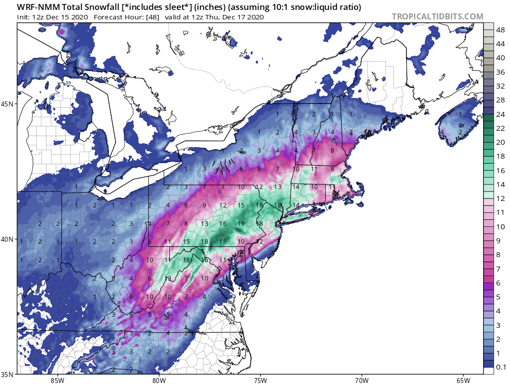
12/16 to 12/17 Godzilla - 1st Call Snow Map
+40
gigs68
WeatherBob
SENJsnowman
Wheezer
Dunnzoo
nutleyblizzard
MattyICE
Irish
bloc1357
RJB8525
rb924119
bobjohnsonforthehall
essexcountypete
elkiehound
DAYBLAZER
crippo84
amugs
heehaw453
sabamfa
CPcantmeasuresnow
sroc4
phil155
docstox12
adamfitz1969
algae888
Math23x7
jimv45
weatherwatchermom
Artechmetals
SoulSingMG
mwilli
billg315
jmanley32
dsix85
Scullybutcher
oldtimer
hyde345
frank 638
aiannone
Frank_Wx
44 posters
Page 8 of 12
Page 8 of 12 •  1, 2, 3 ... 7, 8, 9, 10, 11, 12
 Re: 12/16 to 12/17 Godzilla - 1st Call Snow Map
Ohhhhh you go get the wooden spoon lol or the slip.frank 638 wrote:So I’m guessing for my area in the Bronx it’s going from snow to sleet to crap I just told everyone we’re getting a lot of snow
jmanley32- Senior Enthusiast

- Posts : 20593
Join date : 2013-12-12
aiannone- Senior Enthusiast - Mod

- Posts : 4817
Join date : 2013-01-07
 Re: 12/16 to 12/17 Godzilla - 1st Call Snow Map
Frank_Wx wrote:jmanley32 wrote:So If I am reading all the analysis from our top forcasters here is that this is no longer a big storm for down here? And that its NW is correct and could go even more NW which would give us like nothing or just rain? I have so many people asking me and I got no clue what to tell them cuz the pro mets are still calling a big storm and my news pop ups are flooded with huge storm for NYC.
Tell them 0 to 18"
Sorry, it's just funny when everyone and their brother comes out of the woodwork when a storm is coming. I tell them to watch my facebook page for updates! As long as you are prepared for bad weather, does it really matter if it's 5" or 12"? Only if you are a landscaper I guess, or drive a snowplow, or if you have to work in it. Hmm maybe it does matter! lol
_________________
Janet
Snowfall winter of 2023-2024 17.5"
Snowfall winter of 2022-2023 6.0"
Snowfall winter of 2021-2022 17.6" 1" sleet 2/25/22
Snowfall winter of 2020-2021 51.1"
Snowfall winter of 2019-2020 8.5"
Snowfall winter of 2018-2019 25.1"
Snowfall winter of 2017-2018 51.9"
Snowfall winter of 2016-2017 45.6"
Snowfall winter of 2015-2016 29.5"
Snowfall winter of 2014-2015 50.55"
Snowfall winter of 2013-2014 66.5"

Dunnzoo- Senior Enthusiast - Mod

- Posts : 4910
Reputation : 68
Join date : 2013-01-11
Age : 62
Location : Westwood, NJ
CPcantmeasuresnow likes this post
 Re: 12/16 to 12/17 Godzilla - 1st Call Snow Map
This is super true and I am one to blame, I am trying not to jump on and off and comment on only what is being said at the moment but when all is said and done any snow of 6+ is actually pretty darn good compared to previous years, especially since we have not even reached calender winter yet!! Thanks for bringing me back, I do know a few will see 12-24+ but that may only be mikey P and people way up north not in this form other than math. I guess we have to humble ourselves to the fact that we have to expect and be happy with much less and take the gravy on top if we get it.billg315 wrote:Reading the Mt. Holly discussion from mid-morning they seem well aware of the NW trend and the increasing risk of WAA infiltrating the storm and causing a mixing of precipitation. But it seems despite that they're still confident in this producing a foot or more of snow north and west of the I-95 corridor and in the I-95 corridor still believe several inches are likely even with mixing. So either they believe we've seen as much as we're going to see of a NW drift or they're just slow to back off the WSW they issued early this morning.
I always feel a lot of the angst here is based off of the expectations game too. I've watched these model runs and even on some of the ones that seem disappointing, I'm still getting about 10" of snow as are many others. If a week ago you told me you'll get 6-10" of snow from a storm next Wednesday I would have said, "where do I sign." But when you start thinking in terms of 18-24" suddenly when the models correct lower to the high-singled digits, it seems like the sky is falling (pardon the pun).
Now, if this goes predominately rain, or I get dry slotted and I end up with 1-3" (like that one God awful model run earlier today that CP so appropriately commented on), yeah, I'd be VERY disappointed. But I'm hard pressed to say that if I end up even in a 4-8" range that I shouldn't be happy with that.
So I've yet to see many model runs that still wouldn't produce a significant snow event for many on this board, even if it ends up not being a mega-storm.

jmanley32- Senior Enthusiast

- Posts : 20593
Reputation : 108
Join date : 2013-12-12
Age : 43
Location : Yonkers, NY
 Re: 12/16 to 12/17 Godzilla - 1st Call Snow Map
Irish wrote:TWC just adjusted snow totals for my area in CNJ from 12-18 down to 7-12. Still a very nice storm but the move N&W seems to be happening. Time will tell...
7-12 sounds about right imho, there is too great of a chance that here in central NJ we see mixing, I hope we can avoid a change over but mixing seems somewhat likely to me. I think in this area we have to hope the mixing is short lived or we will for sure see the lower end of predicted totals and may even under perform. I hope not but it is part of living in teh area we live in
phil155- Pro Enthusiast

- Posts : 487
Reputation : 4
Join date : 2019-12-16
 Re: 12/16 to 12/17 Godzilla - 1st Call Snow Map
Thanks to all for the details behind the scenes of an event like this . It's nice to have the pros want to teach others their knowledge and not just post a drive-by map with no explanation. I'm in the Ohio Valley where every winter event teeters on the edge of rain sleet or snow and sharp cut-offs much like the NE. Thanks again
Wheezer- Posts : 30
Reputation : 6
Join date : 2017-11-08
Location : Cincinnati, Oh
 Re: 12/16 to 12/17 Godzilla - 1st Call Snow Map
phil155 wrote:Irish wrote:TWC just adjusted snow totals for my area in CNJ from 12-18 down to 7-12. Still a very nice storm but the move N&W seems to be happening. Time will tell...
7-12 sounds about right imho, there is too great of a chance that here in central NJ we see mixing, I hope we can avoid a change over but mixing seems somewhat likely to me. I think in this area we have to hope the mixing is short lived or we will for sure see the lower end of predicted totals and may even under perform. I hope not but it is part of living in teh area we live in
That last sentence is crucial and so true. We are blessed to live in a region that has very diverse weather events throughout the year. We get nor'easter snowstorms, nor'easter rain storms, ice storms, mix storms, cold snaps, heat waves, severe thunderstorms and even the occasional tropical system. But the curse of living here is that this particular region, from about Wilmington Delaware to NYC/Long Island (including all of NJ) is among the most difficult in the country to forecast when it comes to winter weather events due to the proximity to the mild ocean on one side and elevation on the other and the sensitivity that causes to minor adjustments in storm tracks. Almost every storm around here in the winter is a struggle to forecast along the I-95, and it always will be. And for all of us in this region who love snow, from storm to storm there are almost always winners and losers. Sometimes you're the dog, sometimes you're the fire hydrant.

billg315- Advanced Forecaster - Mod

- Posts : 4511
Reputation : 185
Join date : 2015-01-24
Age : 50
Location : Flemington, NJ
CPcantmeasuresnow, bloc1357, brownie and heehaw453 like this post
 Re: 12/16 to 12/17 Godzilla - 1st Call Snow Map
I believe the National Weather Service and other meteorologist do not make their forecast based off of what models show especially snow Maps. You have to look at the big picture and the features that the models are showing and how that has historically played out in their forecast area. At 1039 mb Arctic high sitting over Quebec with dense cold air and dew point in the single digits with Gulf and Atlantic moisture being drawn into it will always produce a 6in snowfall for the New York City metro area especially with the near record 50/50 low even if it's not in the exact spot that we needed to be. I've seen waa run into a cold high pressure many times in my life and they always produce again if we're looking for 12 to 24 inches of pure snow that very rarely happens here. The National Weather Service showing White Plains in the 12 to 18 inch range is not unreasonable and if they end up with 8 that is still a significant snowstorm for them. It's not turning to rain in White Plains during this event and sleet or freezing rain may end up being a worse Hazard than having a foot to a foot and a half of snow. National Weather Service did the right thing and warning people so soon with this system as it will be a high impact event

algae888- Advanced Forecaster

- Posts : 5311
Reputation : 46
Join date : 2013-02-05
Age : 62
Location : mt. vernon, new york
amugs, bloc1357 and SoulSingMG like this post
 Re: 12/16 to 12/17 Godzilla - 1st Call Snow Map
jimv45 wrote:Jman some of our members are going to get a big storm just don't know who yet, it could be up in Albany with Math! Even me up in Ulster I was thinking this would be south of me now I could be in a great spot or the bigger snows go to my north and west time will tell!
I told you the GFS was on crack. I think we are looking pretty good right now. We will see.

hyde345- Pro Enthusiast

- Posts : 1082
Reputation : 48
Join date : 2013-01-08
Location : Hyde Park, NY
 Re: 12/16 to 12/17 Godzilla - 1st Call Snow Map
Yes Hyde expect about a foot or even more, but like you said will see!!!
jimv45- Senior Enthusiast

- Posts : 1168
Reputation : 36
Join date : 2013-09-20
Location : Hopewell jct.

SoulSingMG- Senior Enthusiast

- Posts : 2853
Reputation : 74
Join date : 2013-12-11
Location : Long Island City, NY
 Re: 12/16 to 12/17 Godzilla - 1st Call Snow Map
i'm curious to see how much Mt Holly knocks back totals if at all for NW NJ Warren/Sussex. anything over 6" is good IMO beats what we got last year..NOTHING lol

RJB8525- Senior Enthusiast

- Posts : 1994
Reputation : 28
Join date : 2013-02-06
Age : 38
Location : Hackettstown, NJ
 Re: 12/16 to 12/17 Godzilla - 1st Call Snow Map
Latest HRRR is all snow for LI points N+W but does dry slot the area a bit. when backside comes through it's sleet
Last edited by aiannone on Tue Dec 15, 2020 2:41 pm; edited 1 time in total
_________________
-Alex Iannone-

aiannone- Senior Enthusiast - Mod

- Posts : 4817
Reputation : 92
Join date : 2013-01-07
Location : Saint James, LI (Northwest Suffolk Co.)
 Re: 12/16 to 12/17 Godzilla - 1st Call Snow Map
so what is your thinking for low end and high end for us in southern Westchester? Or let's say the metro area? 0 to 18 like Frank said lolalgae888 wrote:I believe the National Weather Service and other meteorologist do not make their forecast based off of what models show especially snow Maps. You have to look at the big picture and the features that the models are showing and how that has historically played out in their forecast area. At 1039 mb Arctic high sitting over Quebec with dense cold air and dew point in the single digits with Gulf and Atlantic moisture being drawn into it will always produce a 6in snowfall for the New York City metro area especially with the near record 50/50 low even if it's not in the exact spot that we needed to be. I've seen waa run into a cold high pressure many times in my life and they always produce again if we're looking for 12 to 24 inches of pure snow that very rarely happens here. The National Weather Service showing White Plains in the 12 to 18 inch range is not unreasonable and if they end up with 8 that is still a significant snowstorm for them. It's not turning to rain in White Plains during this event and sleet or freezing rain may end up being a worse Hazard than having a foot to a foot and a half of snow. National Weather Service did the right thing and warning people so soon with this system as it will be a high impact event

jmanley32- Senior Enthusiast

- Posts : 20593
Reputation : 108
Join date : 2013-12-12
Age : 43
Location : Yonkers, NY

aiannone- Senior Enthusiast - Mod

- Posts : 4817
Reputation : 92
Join date : 2013-01-07
Location : Saint James, LI (Northwest Suffolk Co.)
heehaw453- Advanced Forecaster

- Posts : 3906
Reputation : 86
Join date : 2014-01-20
Location : Bedminster Township, PA Elevation 600' ASL
RJB8525 likes this post
 Re: 12/16 to 12/17 Godzilla - 1st Call Snow Map
Hrrr actually has sleet all along and a bit north of long Island. Still a good 6 to 12 I think and it's not done on the run.

jmanley32- Senior Enthusiast

- Posts : 20593
Reputation : 108
Join date : 2013-12-12
Age : 43
Location : Yonkers, NY
SENJsnowman- Senior Enthusiast

- Posts : 1189
Reputation : 61
Join date : 2017-01-06
Age : 51
Location : Bayville, NJ
CPcantmeasuresnow likes this post
 Re: 12/16 to 12/17 Godzilla - 1st Call Snow Map
Jman 6 to 12 in for Westchester 4 to 8-in for the city

algae888- Advanced Forecaster

- Posts : 5311
Reputation : 46
Join date : 2013-02-05
Age : 62
Location : mt. vernon, new york
 Re: 12/16 to 12/17 Godzilla - 1st Call Snow Map
To my point on the last page, the HRRR shows the rain getting pretty far north and a period of mixing near the middle and end of the storm in North Jersey before going to back to snow at the end, but still gives most people (except the immediate NJ coastline) anywhere from 6-10". That's a pretty good storm, even with mixing issues.

billg315- Advanced Forecaster - Mod

- Posts : 4511
Reputation : 185
Join date : 2015-01-24
Age : 50
Location : Flemington, NJ
 Re: 12/16 to 12/17 Godzilla - 1st Call Snow Map
I love how where the red ends next to Upton on hot one map it's orange. They don't have to make some kind of agreement between the two coverage areas for it to make sense if put together like a puzzles?

jmanley32- Senior Enthusiast

- Posts : 20593
Reputation : 108
Join date : 2013-12-12
Age : 43
Location : Yonkers, NY
 Re: 12/16 to 12/17 Godzilla - 1st Call Snow Map
jmanley32 wrote:I love how where the red ends next to Upton on hot one map it's orange. They don't have to make some kind of agreement between the two coverage areas for it to make sense if put together like a puzzles?
i agree it's always funny in your head you can picture putting both NWS map totals together to complete a puzzle

RJB8525- Senior Enthusiast

- Posts : 1994
Reputation : 28
Join date : 2013-02-06
Age : 38
Location : Hackettstown, NJ
 Re: 12/16 to 12/17 Godzilla - 1st Call Snow Map
Naim coming in a little flatter height are lower and better Confluence to our North it should be a better run than 12z low pressure also 2 millibars weaker in the Gulf

algae888- Advanced Forecaster

- Posts : 5311
Reputation : 46
Join date : 2013-02-05
Age : 62
Location : mt. vernon, new york
 Re: 12/16 to 12/17 Godzilla - 1st Call Snow Map
_________________
_______________________________________________________________________________________________________
CLICK HERE to view NJ Strong Snowstorm Classifications
 Re: 12/16 to 12/17 Godzilla - 1st Call Snow Map
With the way things are looking now I am hoping for that much. Any revert on the models which looks unlikely from what I am reading would be gravy at this pt. 6-12 a week ago if I was told I would be dancing. Its taking perspective I guess.algae888 wrote:Jman 6 to 12 in for Westchester 4 to 8-in for the city

jmanley32- Senior Enthusiast

- Posts : 20593
Reputation : 108
Join date : 2013-12-12
Age : 43
Location : Yonkers, NY
 Re: 12/16 to 12/17 Godzilla - 1st Call Snow Map
Irish wrote:TWC just adjusted snow totals for my area in CNJ from 12-18 down to 7-12. Still a very nice storm but the move N&W seems to be happening. Time will tell...
Totals dropped again to 6-10".

Irish- Pro Enthusiast

- Posts : 788
Reputation : 19
Join date : 2019-01-16
Age : 45
Location : Old Bridge, NJ
 Re: 12/16 to 12/17 Godzilla - 1st Call Snow Map
18z NAM so far west it's in the chesapeake
_________________
-Alex Iannone-

aiannone- Senior Enthusiast - Mod

- Posts : 4817
Reputation : 92
Join date : 2013-01-07
Location : Saint James, LI (Northwest Suffolk Co.)
Page 8 of 12 •  1, 2, 3 ... 7, 8, 9, 10, 11, 12
Page 8 of 12
Permissions in this forum:
You cannot reply to topics in this forum
 Home
Home


