2021 Tropical Season
+35
Lubethan
sabamfa
Radz
clownloach
WeatherBob
dsix85
jimv45
Joe Snow
Scullybutcher
dolphins222
JackShephard
phil155
hyde345
essexcountypete
Nyi1058
nutleyblizzard
Zhukov1945
Grselig
Sanchize06
SoulSingMG
SENJsnowman
Dunnzoo
tomsriversnowstorm
dkodgis
rb924119
Vinnydula
aiannone
New Yorker 234
frank 638
billg315
weatherwatchermom
sroc4
Frank_Wx
jmanley32
amugs
39 posters
Page 40 of 43
Page 40 of 43 •  1 ... 21 ... 39, 40, 41, 42, 43
 Re: 2021 Tropical Season
rb924119 wrote:jmanley32 wrote:so ray (rb) I saw 18z GFS, the system that is now a depression goes NW and then north I see the HP, if the HP were 500 miles more west would been a direct hit on us, are you thinking the HP is much further west than shown?
Kind of lol it’s a very complex evolution that would have to occur in order for it to be a threat to us, but just because it’s complex, it doesn’t mean that it can’t/won’t happen.
Basically, I’m banking on the Atlantic ridge being undermodeled for two reasons:
1. The anomalously warm ocean waters should lead to its enhancement
2. The depression should readily achieve Major hurricane status, so that will work to add additional latent heat into the ridge and help to further build its western flank. This would start to lead to a positive feedback loop in tandem with (1). As the ridge builds westward in response to the hurricane moving westward, it should continue to steer the hurricane westward, thereby allowing the ridge to continue to build westward.
However, that’s the “easier” part of the forecast. The complexity comes in with how the pattern sets up over the eastern CONUS, and how the trough behaves. Basically, if you watch the entire loop of the hemispheric H5 anomalies, you’ll notice that there is discontinuous retrogression occurring. For example, the time-mean trough starts over Newfoundland, then shifts westward to be over the Northeast, then shifts westward to be over the Great Lakes. This fits the logical progression of the remnant Atlantic blocking, but it’s contained within an overall hemispheric and global pattern that supports ridging in the eastern CONUS.
This is where it gets tricky fast. How does that retrograding trough behave? Does it cut off and drift southward over east-central CONUS and allow the ridging to build over the top of it (anti-cyclonic wave break) and eventually link up with the Atlantic ridging building westward, as the trough/cutoff low decays? Or, do we see a decrease in the amplitude of the trough as the lead time decreases, and then see the main trough split, with one piece ejecting northeastward through northern New England/southern Canada, and the other slip back in response to additional energy being allowed to slip in the backside and continue the retrogression of the mean trough toward the central CONUS?
I can’t really offer concrete opinion on the evolutions that would follow yet, but my concern is with the second evolution IF it evolved that way. Because with the trough split, it should allow heights to build faster to the northwest of the hurricane, thereby increasing the time of westward movement (ala today’s 12z GEM). However, with that second piece hanging back, it would still allow for a window to come almost due north (similarly to Henri, though without the retrograde).
If the first option evolved, then it would be more of a threat for the Southeast.
This is all very preliminary musing on my end, though, as I’ve not yet had a real chance to sit and analyze. Thursday or Friday should offer me that opportunity, though I will try to dabble before then.
Hey Ray I have to throw my two cents into the ring here. With Larry forecast to gain intensity rather quickly, even up to a major By the end of the week the altitude at which will influence Larry's motion begin to increase. Looking at 300mb there is a very distinct northerly vector by the time Larry reaches approx 45-50W Long; whereas, beneath that at 500mb the vecotor still seems to be westerly. Also good ol' Coriolis forces come into play the stronger he gets too.
Combined with the timing of the various troughs propagating NA into the Atlantic just something else to factor when looking at "Larry Balls". Sorry Larry Balls was the nick name to a guy I used to hang out with back in my high school days. I digress
sroc4- Admin

- Posts : 8449
Join date : 2013-01-07
 Re: 2021 Tropical Season
sroc4 wrote:rb924119 wrote:jmanley32 wrote:so ray (rb) I saw 18z GFS, the system that is now a depression goes NW and then north I see the HP, if the HP were 500 miles more west would been a direct hit on us, are you thinking the HP is much further west than shown?
Kind of lol it’s a very complex evolution that would have to occur in order for it to be a threat to us, but just because it’s complex, it doesn’t mean that it can’t/won’t happen.
Basically, I’m banking on the Atlantic ridge being undermodeled for two reasons:
1. The anomalously warm ocean waters should lead to its enhancement
2. The depression should readily achieve Major hurricane status, so that will work to add additional latent heat into the ridge and help to further build its western flank. This would start to lead to a positive feedback loop in tandem with (1). As the ridge builds westward in response to the hurricane moving westward, it should continue to steer the hurricane westward, thereby allowing the ridge to continue to build westward.
However, that’s the “easier” part of the forecast. The complexity comes in with how the pattern sets up over the eastern CONUS, and how the trough behaves. Basically, if you watch the entire loop of the hemispheric H5 anomalies, you’ll notice that there is discontinuous retrogression occurring. For example, the time-mean trough starts over Newfoundland, then shifts westward to be over the Northeast, then shifts westward to be over the Great Lakes. This fits the logical progression of the remnant Atlantic blocking, but it’s contained within an overall hemispheric and global pattern that supports ridging in the eastern CONUS.
This is where it gets tricky fast. How does that retrograding trough behave? Does it cut off and drift southward over east-central CONUS and allow the ridging to build over the top of it (anti-cyclonic wave break) and eventually link up with the Atlantic ridging building westward, as the trough/cutoff low decays? Or, do we see a decrease in the amplitude of the trough as the lead time decreases, and then see the main trough split, with one piece ejecting northeastward through northern New England/southern Canada, and the other slip back in response to additional energy being allowed to slip in the backside and continue the retrogression of the mean trough toward the central CONUS?
I can’t really offer concrete opinion on the evolutions that would follow yet, but my concern is with the second evolution IF it evolved that way. Because with the trough split, it should allow heights to build faster to the northwest of the hurricane, thereby increasing the time of westward movement (ala today’s 12z GEM). However, with that second piece hanging back, it would still allow for a window to come almost due north (similarly to Henri, though without the retrograde).
If the first option evolved, then it would be more of a threat for the Southeast.
This is all very preliminary musing on my end, though, as I’ve not yet had a real chance to sit and analyze. Thursday or Friday should offer me that opportunity, though I will try to dabble before then.
Hey Ray I have to throw my two cents into the ring here. With Larry forecast to gain intensity rather quickly, even up to a major By the end of the week the altitude at which will influence Larry's motion begin to increase. Looking at 300mb there is a very distinct northerly vector by the time Larry reaches approx 45-50W Long; whereas, beneath that at 500mb the vecotor still seems to be westerly. Also good ol' Coriolis forces come into play the stronger he gets too.
Combined with the timing of the various troughs propagating NA into the Atlantic just something else to factor when looking at "Larry Balls". Sorry Larry Balls was the nick name to a guy I used to hang out with back in my high school days. I digress
Oh yeah, I fully agree and acknowledged that the climatological probability strongly supports a recurve harmlessly out to sea. I’m just not sure that will be the result. At least yet.
rb924119- Meteorologist

- Posts : 7043
Reputation : 195
Join date : 2013-02-06
Age : 32
Location : Greentown, Pa
sroc4 likes this post
phil155- Pro Enthusiast

- Posts : 494
Reputation : 4
Join date : 2019-12-16
SoulSingMG likes this post
 Re: 2021 Tropical Season
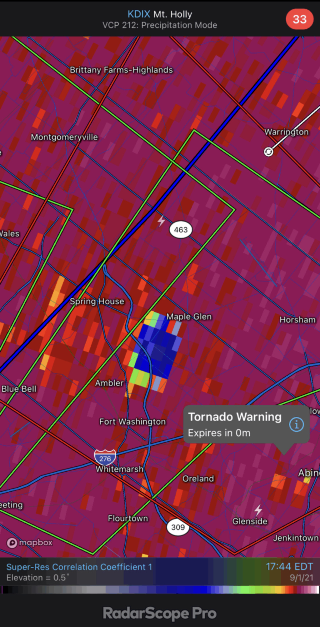
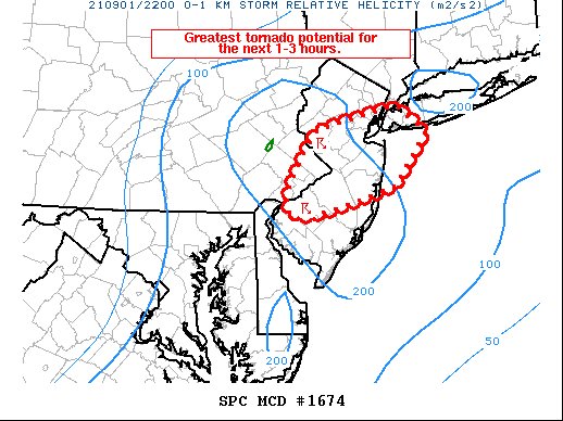
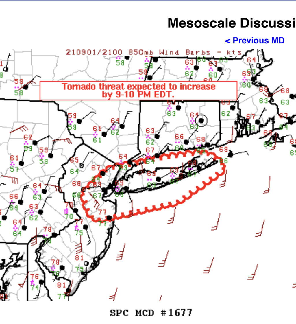
No tornado watch here yet anyways, probably ol' usual upton, we are also on the upper north fringe of the potential, we will see. Concerning none-the-less, not all that frequent we experience this risk.
Last edited by jmanley32 on Wed Sep 01, 2021 12:54 pm; edited 1 time in total

jmanley32- Senior Enthusiast

- Posts : 20639
Reputation : 108
Join date : 2013-12-12
Age : 43
Location : Yonkers, NY
 Re: 2021 Tropical Season
THE NATIONAL WEATHER SERVICE HAS ISSUED TORNADO WATCH 483 IN EFFECT UNTIL 10 PM EDT THIS EVENING FOR THE FOLLOWING AREAS
IN DELAWARE THIS WATCH INCLUDES 3 COUNTIES
IN CENTRAL DELAWARE
KENT
IN NORTHERN DELAWARE
NEW CASTLE
IN SOUTHERN DELAWARE
SUSSEX
IN MARYLAND THIS WATCH INCLUDES 4 COUNTIES
IN NORTHEAST MARYLAND
CAROLINE KENT QUEEN ANNE'S TALBOT
IN NEW JERSEY THIS WATCH INCLUDES 15 COUNTIES
IN CENTRAL NEW JERSEY
MERCER MONMOUTH
IN NORTHERN NEW JERSEY
HUNTERDON MIDDLESEX MORRIS SOMERSET WARREN
IN SOUTHERN NEW JERSEY
ATLANTIC BURLINGTON CAMDEN CAPE MAY CUMBERLAND GLOUCESTER OCEAN SALEM
IN PENNSYLVANIA THIS WATCH INCLUDES 8 COUNTIES
IN EAST CENTRAL PENNSYLVANIA
BERKS LEHIGH NORTHAMPTON
IN SOUTHEAST PENNSYLVANIA
BUCKS CHESTER DELAWARE MONTGOMERY PHILADELPHIA
THIS INCLUDES THE CITIES OF ALLENTOWN, ATLANTIC CITY, BETHLEHEM, BLAIRSTOWN, CAMDEN, CENTREVILLE, CHERRY HILL, CHESTERTOWN, DENTON, DEPTFORD, DOVER, DOYLESTOWN, EAST BRUNSWICK, EASTON, EASTON, EDISON, FLEMINGTON, FREEHOLD, GEORGETOWN, GLASSBORO, HAMMONTON, MEDIA, MILLVILLE, MOORESTOWN, MORRISTOWN, MOUNT HOLLY, NEW BRUNSWICK, NORRISTOWN, NORTH BRUNSWICK TOWNSHIP, OCEAN CITY, PENNSVILLE, PERTH AMBOY, PHILADELPHIA, READING, SAYREVILLE, SOMERSET, TOMS RIVER, TRENTON, WEST CHESTER, AND WILMINGTON.
phil155- Pro Enthusiast

- Posts : 494
Reputation : 4
Join date : 2019-12-16
 Re: 2021 Tropical Season
My sister is at the beach in delaware with the family. Says it is a very nice day, does not seem at all concerned.

jmanley32- Senior Enthusiast

- Posts : 20639
Reputation : 108
Join date : 2013-12-12
Age : 43
Location : Yonkers, NY
 Re: 2021 Tropical Season
a lot of tornadoes already this year, I do not recall a year this active off the top of my head
phil155- Pro Enthusiast

- Posts : 494
Reputation : 4
Join date : 2019-12-16

Zhukov1945- Posts : 138
Reputation : 8
Join date : 2018-03-21
Location : Clinton Township NJ
 Re: 2021 Tropical Season
WOW, the grid below the tornado watch is not one you ever see for the area with HIGH as the parameter for tornadoes and severe wind. I have not seen high for this area under tornados ever that I can remember.
https://www.spc.noaa.gov/products/watch/ww0483.html
https://www.spc.noaa.gov/products/watch/ww0483.html

jmanley32- Senior Enthusiast

- Posts : 20639
Reputation : 108
Join date : 2013-12-12
Age : 43
Location : Yonkers, NY

jmanley32- Senior Enthusiast

- Posts : 20639
Reputation : 108
Join date : 2013-12-12
Age : 43
Location : Yonkers, NY
Zhukov1945 likes this post
 I am in Villas NJ on the Delaware Bay. Beautiful day, hard to believe it is about to drastically change
jmanley32 wrote:My sister is at the beach in delaware with the family. Says it is a very nice day, does not seem at all concerned.
Lubethan- Posts : 3
Reputation : 0
Join date : 2018-03-20
Age : 49
Location : Bordentown NJ
 Re: 2021 Tropical Season
Down in South Jersey near Atlantic City.....Warm and the sun is shining
larryrock72- Posts : 141
Reputation : 5
Join date : 2017-01-03
Age : 52
Location : Barnegat, NJ
 Re: 2021 Tropical Season
It has been raining steady all day. At 2 pm it tailed off with a very little bit of rainfall until about 3:15 pm when it really started. I see five inches of rain since this morning; it is really coming down now. if it rains like this until early morning, that's a lot of rain.

dkodgis- Senior Enthusiast

- Posts : 2672
Reputation : 98
Join date : 2013-12-29
 Re: 2021 Tropical Season
Wow there are 5 tornado warnings to the south of us in the midatlantic advancing north, not good. They will probably only continue to spawn potential tornados, 2 confirmed already.

jmanley32- Senior Enthusiast

- Posts : 20639
Reputation : 108
Join date : 2013-12-12
Age : 43
Location : Yonkers, NY
 Re: 2021 Tropical Season
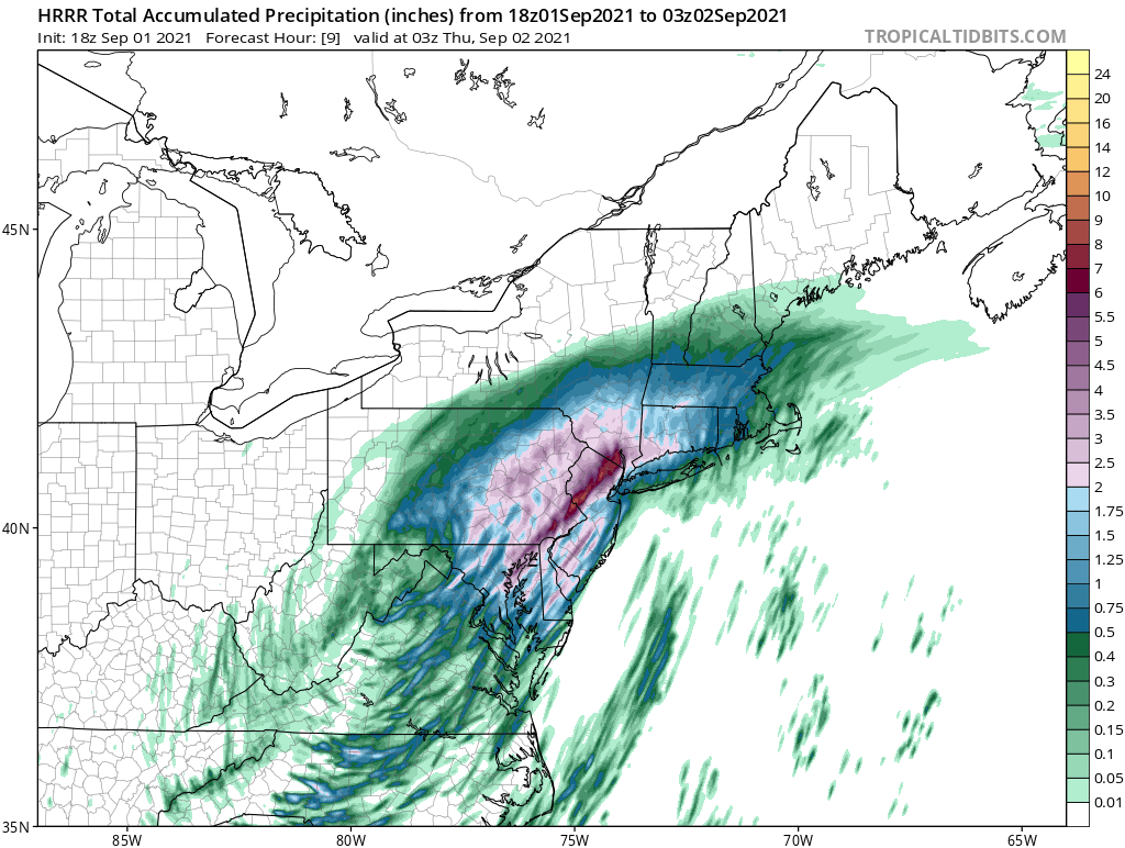
jmanley32 wrote:your avatar is huge too, i cannot see what you write on the left, Frank can you find out why this is happening for a few individuals? Looks like HRRR is shifting the heaviest rain back south. At this point who knows
Changed it and hopefully it fixed the issue. Latest HRRR still likes that intense band over Hunterdon headed NE, been consistent with that all day


Zhukov1945- Posts : 138
Reputation : 8
Join date : 2018-03-21
Location : Clinton Township NJ
 Re: 2021 Tropical Season
we should prolly move all this talk to sept. observation thread. technically this isnt really about the tropics.Zhukov1945 wrote:jmanley32 wrote:your avatar is huge too, i cannot see what you write on the left, Frank can you find out why this is happening for a few individuals? Looks like HRRR is shifting the heaviest rain back south. At this point who knows
Changed it and hopefully it fixed the issue. Latest HRRR still likes that intense band over Hunterdon headed NE, been consistent with that all day

jmanley32- Senior Enthusiast

- Posts : 20639
Reputation : 108
Join date : 2013-12-12
Age : 43
Location : Yonkers, NY

SoulSingMG- Senior Enthusiast

- Posts : 2853
Reputation : 74
Join date : 2013-12-11
Location : Long Island City, NY
amugs likes this post
 Re: 2021 Tropical Season
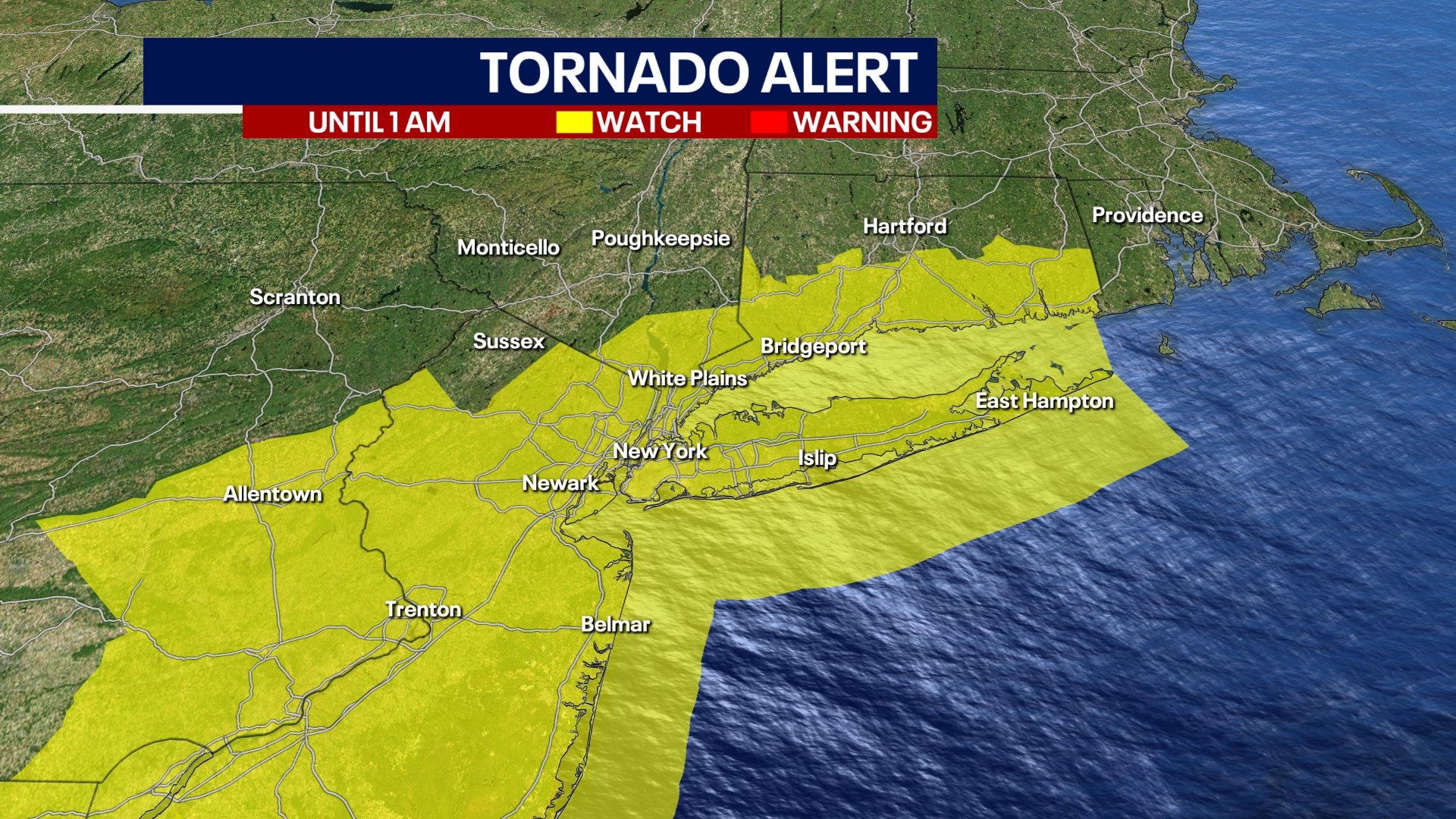
Torn Watch until 1AM for every county except Sussex in NJ!!

_________________
Mugs
AKA:King: Snow Weenie
Self Proclaimed
WINTER 2014-15 : 55.12" +.02 for 6 coatings (avg. 35")
WINTER 2015-16 Total - 29.8" (Avg 35")
WINTER 2016-17 : 39.5" so far

amugs- Advanced Forecaster - Mod

- Posts : 15133
Reputation : 213
Join date : 2013-01-07
Age : 54
Location : Hillsdale,NJ
 Re: 2021 Tropical Season
From FF on 33nRain bd
NNJn SE NY needs less than .75 in a 6 hour period to have flooding this map says - U-G-L-Y!!

NNJn SE NY needs less than .75 in a 6 hour period to have flooding this map says - U-G-L-Y!!

_________________
Mugs
AKA:King: Snow Weenie
Self Proclaimed
WINTER 2014-15 : 55.12" +.02 for 6 coatings (avg. 35")
WINTER 2015-16 Total - 29.8" (Avg 35")
WINTER 2016-17 : 39.5" so far

amugs- Advanced Forecaster - Mod

- Posts : 15133
Reputation : 213
Join date : 2013-01-07
Age : 54
Location : Hillsdale,NJ

SoulSingMG- Senior Enthusiast

- Posts : 2853
Reputation : 74
Join date : 2013-12-11
Location : Long Island City, NY

Joe Snow- Pro Enthusiast

- Posts : 933
Reputation : 7
Join date : 2014-02-12
Age : 62
Location : Sanford Florida, Fmrly Kings Park, NY
 Re: 2021 Tropical Season
So whats the story with Larry rb? Or maybe we should give it the weekend to recover, today was hell on earth. I do not even want to talk about it. I will never forget this storm. ranks up there with Sandy for me. MAYBE HIGHER.

jmanley32- Senior Enthusiast

- Posts : 20639
Reputation : 108
Join date : 2013-12-12
Age : 43
Location : Yonkers, NY
 Re: 2021 Tropical Season
jmanley32 wrote:So whats the story with Larry rb? Or maybe we should give it the weekend to recover, today was hell on earth. I do not even want to talk about it. I will never forget this storm. ranks up there with Sandy for me. MAYBE HIGHER.
I do think we are going to get another cane this way.

Joe Snow- Pro Enthusiast

- Posts : 933
Reputation : 7
Join date : 2014-02-12
Age : 62
Location : Sanford Florida, Fmrly Kings Park, NY
 Re: 2021 Tropical Season
If it is worse than this (and that is odd to say as this was a TD...) then I am done, I sign off over and out lol. Road rage deluxe today, nowhere to go. someone sideswiped my car and sped off i chased them into traffic got out tride snap their license plate but they sped off b4 i could, one video taped me chasing them saying he was report me to the police...good I have you on camera photographing me lmao, jerks. its not bad damage but not a old car and will cost me a few hundred to repaint bumper prolly more for a really good one. So angry. I have so many pics but they all on my cell.Joe Snow wrote:jmanley32 wrote:So whats the story with Larry rb? Or maybe we should give it the weekend to recover, today was hell on earth. I do not even want to talk about it. I will never forget this storm. ranks up there with Sandy for me. MAYBE HIGHER.
I do think we are going to get another cane this way.

jmanley32- Senior Enthusiast

- Posts : 20639
Reputation : 108
Join date : 2013-12-12
Age : 43
Location : Yonkers, NY
 Re: 2021 Tropical Season
The trend west with Larry on GFS is real last 3 runs of GFS pushing it closer and closer to the northeast, I know it is 168 hrs out and the waffling will be wild but ray (rb) may be onto something, still waiting on that expert analysis ray : )

jmanley32- Senior Enthusiast

- Posts : 20639
Reputation : 108
Join date : 2013-12-12
Age : 43
Location : Yonkers, NY
 Re: 2021 Tropical Season
Larry? Hurricane Larry, it doesn’t even sound like a hurricane name.
Sounds more like a friend that comes over just to drink your beer.
Yes it’s trending west.
Watch this be the “one”
Larry no less ….
Sounds more like a friend that comes over just to drink your beer.
Yes it’s trending west.
Watch this be the “one”
Larry no less ….

Joe Snow- Pro Enthusiast

- Posts : 933
Reputation : 7
Join date : 2014-02-12
Age : 62
Location : Sanford Florida, Fmrly Kings Park, NY
Page 40 of 43 •  1 ... 21 ... 39, 40, 41, 42, 43
Page 40 of 43
Permissions in this forum:
You cannot reply to topics in this forum
 Home
Home

