Long Range Discussion 22.0
Page 17 of 31 •  1 ... 10 ... 16, 17, 18 ... 24 ... 31
 Re: Long Range Discussion 22.0
rb924119 wrote:SENJsnowman wrote:Rb, are the horrific temps and pattern coming up for this week a direct manifestation of “the worse it gets sooner, the better it will be later” that you have been alluding to?
Not just the next week or so, but the whole month of December as well haha it’s a process that takes time evolve, and we are nearing the point in that evolution where it’s darkest just before dawn. At least in my opinion.
So far RB it does look like your forecast is coming into better view we approach January. Also there are some hints of PV lobe displacement coming from Hudson Bay that could enhance the colder temps. All I can say is I want to believe, I really do, but I just need to see things materialize further to have much confidence.
heehaw453- Advanced Forecaster

- Posts : 3916
Join date : 2014-01-20
sroc4, rb924119, SENJsnowman and phil155 like this post
 Re: Long Range Discussion 22.0
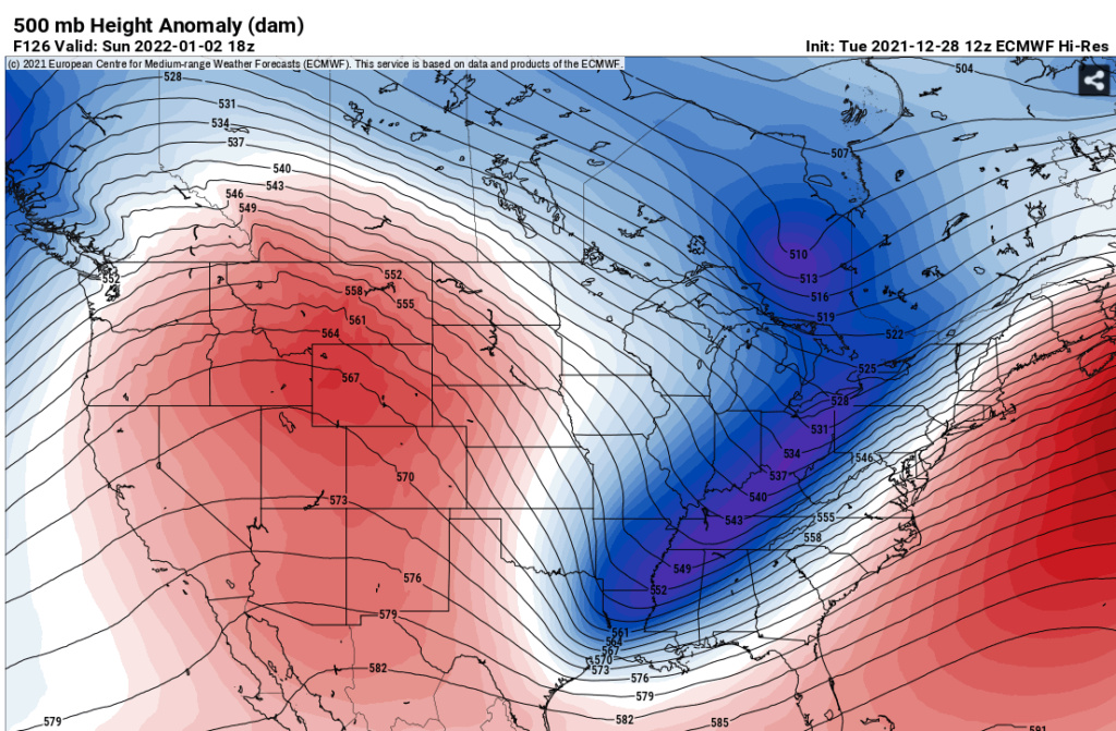
heehaw453 wrote:The 12Z Euro western heights are pumped tantamount with GFS. The issue is you don't have much s/w energy rounding the base of the trough and it's a bit of a positive tilt. If this was to amount to anything I'd like to see more neutral tilt and some s/w energy rounding the base. However, any s/w energy sampling won't be for a few days, and the tilt could definitely be adjusted at this range. I'd just say low probability window right now.
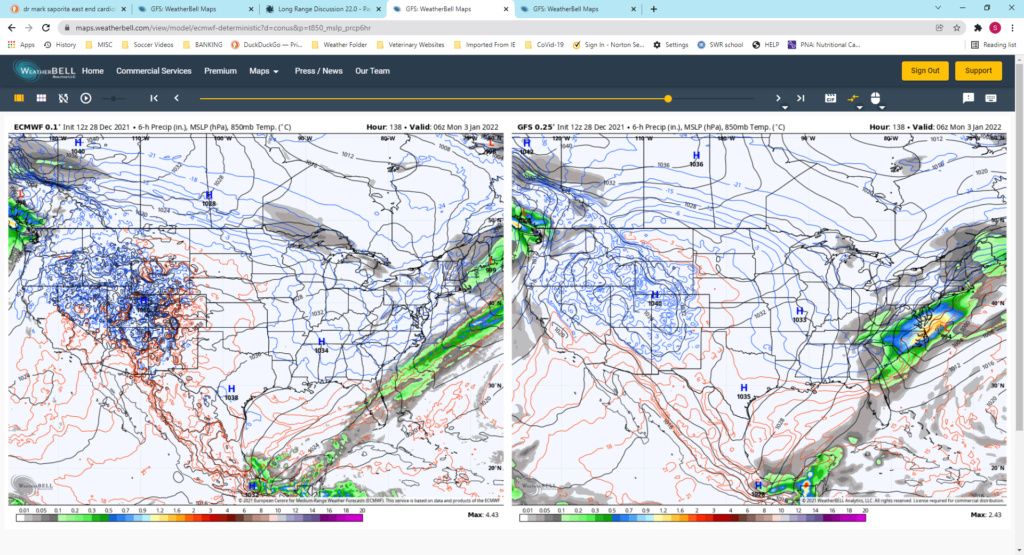
The real difference between the two is the timing and positioning of the energy early on. Look at the difference between the side by sides with Euro on the left and GFS on the right by hr 90. Euro already phasing alot of energy where as GFS is not.

Its messy with all that phasing energy as it exits into the Plains and heads into the east but by hr 126 on the Euro, which coincides with the image you posted above, it results in one long strong strung out progressive line of vorticity and a seperate thinner line of vort well out ahead of it just off the E coast ; hence the very positive tilt you mention whereas the GFS is weaker with the trailing line of vorticity and taking its time but catching up with the second leading line of vorticity.

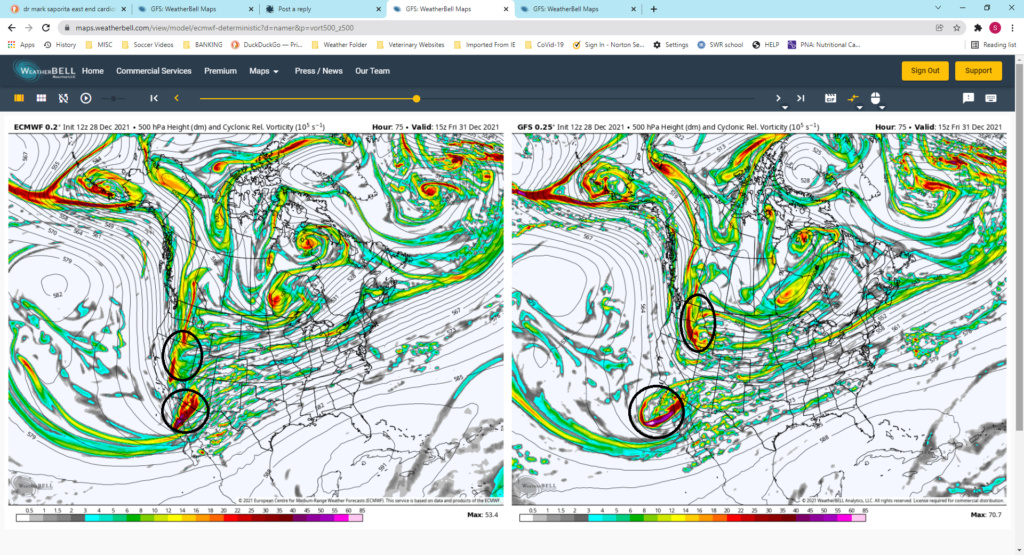
Notice the difference between the gap between the two lines I drew outlining the two areas of SW to NE oriented vorticity on both models on both hr 126 and the last image which is hr 138. The euro keeps both lines or vort separate hence the warmer run and no storm forming south of us. The GFS however catches up with that energy and you get a phase, and hence a storm develop to the south and a colder soln. The phase is just a few hours too late so you still have a pos tilt,(albiet much less pos/closer to neutral tilt) relative to the euro soln, and the system scrapes the area.

Overall if you look at the western trough in the side by side comparisons they look pretty damn similar which is good news. There is SO much energy coming into the west coast of NA and diving in from Alaska etc that I think its still at least 2 days before we start to see some consistency with how models from run to run depict all the energy. Heck look at the energy difference even at hr 75 on the side by side:
sroc4- Admin

- Posts : 8449
Join date : 2013-01-07
heehaw453, Wheezer and phil155 like this post
 Re: Long Range Discussion 22.0
_________________
Mugs
AKA:King: Snow Weenie
Self Proclaimed
WINTER 2014-15 : 55.12" +.02 for 6 coatings (avg. 35")
WINTER 2015-16 Total - 29.8" (Avg 35")
WINTER 2016-17 : 39.5" so far

amugs- Advanced Forecaster - Mod

- Posts : 15133
Reputation : 213
Join date : 2013-01-07
Age : 54
Location : Hillsdale,NJ
 Re: Long Range Discussion 22.0
1. Off-hour model suites
2. Using analogs as a foundation for a forecast
BUT……
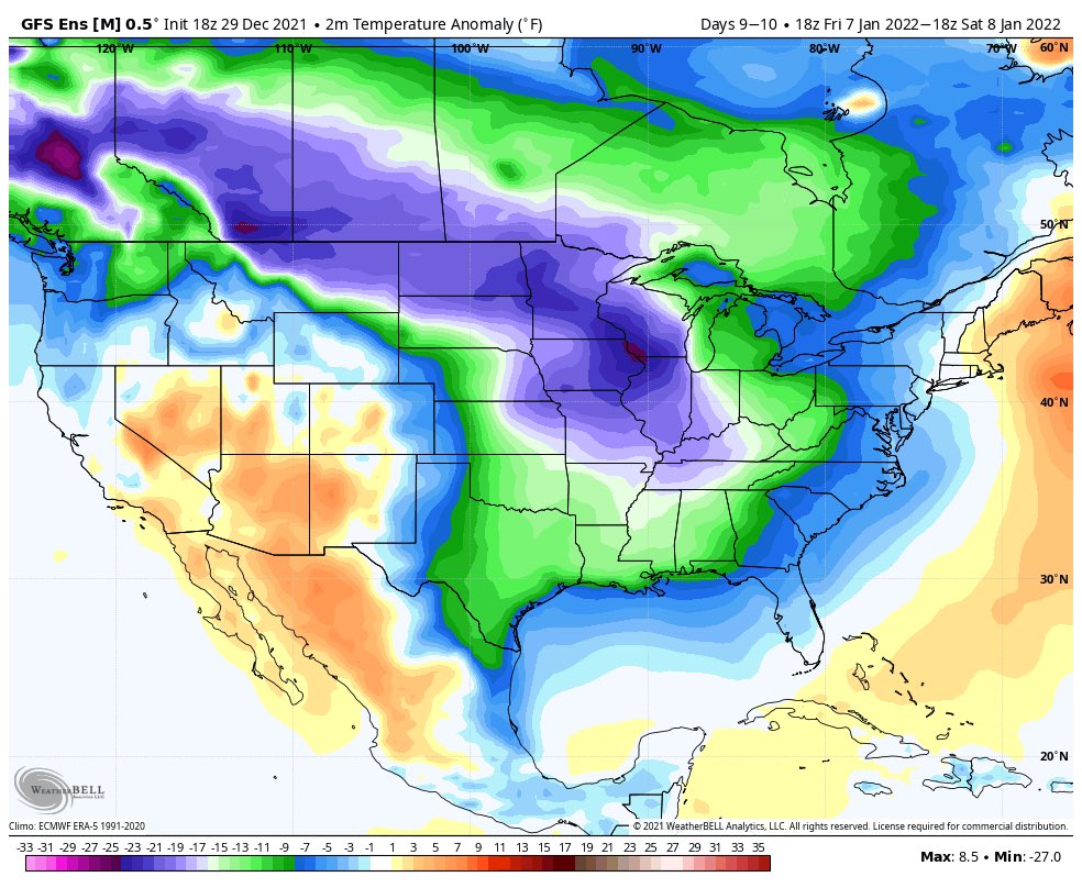
1. Tonight’s 18z GFS Ensemble does a decent job at depicting where I think we are headed, and actually establishes a true cross-polar flow from Siberia directly into the U.S. so if you want crème de la crème cold air, that’s how you get it.
2. I got curious about where I might have seen this type of progression before…….and at a quick glance, ‘93-‘94 seems to be a pretty d@mn close match in both the Troposphere AND the Stratosphere.
Now I’m not saying that this winter will be legendary like that one was, but it raised my eyebrows for sure. I may put together a longer post later, idk, I’m working all night. But we’ll see. But I found that VERY interesting.
rb924119- Meteorologist

- Posts : 7043
Reputation : 195
Join date : 2013-02-06
Age : 32
Location : Greentown, Pa
amugs, MattyICE and Bwtr like this post
 Re: Long Range Discussion 22.0
As the EPS Ctrl run progresses, note the location of the subtropical high as it temporarily moves east, before retreating back to the west. A clean MJO pass into 8-1 would assist with anchoring this high (and jet extension) to the east pic.twitter.com/2hiEXfnuQ1
— griteater (@griteater) December 28, 2021
_________________
Mugs
AKA:King: Snow Weenie
Self Proclaimed
WINTER 2014-15 : 55.12" +.02 for 6 coatings (avg. 35")
WINTER 2015-16 Total - 29.8" (Avg 35")
WINTER 2016-17 : 39.5" so far

amugs- Advanced Forecaster - Mod

- Posts : 15133
Reputation : 213
Join date : 2013-01-07
Age : 54
Location : Hillsdale,NJ
rb924119 likes this post
 Re: Long Range Discussion 22.0
rb924119- Meteorologist

- Posts : 7043
Reputation : 195
Join date : 2013-02-06
Age : 32
Location : Greentown, Pa
weatherwatchermom and SENJsnowman like this post
 Re: Long Range Discussion 22.0
rb924119 wrote:Y’all know how I feel about:
1. Off-hour model suites
2. Using analogs as a foundation for a forecast
BUT……
1. Tonight’s 18z GFS Ensemble does a decent job at depicting where I think we are headed, and actually establishes a true cross-polar flow from Siberia directly into the U.S. so if you want crème de la crème cold air, that’s how you get it.
2. I got curious about where I might have seen this type of progression before…….and at a quick glance, ‘93-‘94 seems to be a pretty d@mn close match in both the Troposphere AND the Stratosphere.
Now I’m not saying that this winter will be legendary like that one was, but it raised my eyebrows for sure. I may put together a longer post later, idk, I’m working all night. But we’ll see. But I found that VERY interesting.
Regarding my second point, the comparison is not as close as I first thought. Several factors were different earlier in the season, so it’s not a fair comparison. But my first point still stands haha
rb924119- Meteorologist

- Posts : 7043
Reputation : 195
Join date : 2013-02-06
Age : 32
Location : Greentown, Pa
weatherwatchermom likes this post
 Re: Long Range Discussion 22.0
heehaw453- Advanced Forecaster

- Posts : 3916
Reputation : 86
Join date : 2014-01-20
Location : Bedminster Township, PA Elevation 600' ASL
rb924119 likes this post
 Re: Long Range Discussion 22.0
heehaw453 wrote:Better PAC look seems to be on track passed January 7. It may come at the expense of the Arctic/Atlantic (AO/NAO) for a while. My thoughts are the western trough does FINALLY lift out which bleeds some colder air in, but then you get a fairly unfavorable AO/NAO. As I said before you normally have to give something to get something with these long wave patterns. It's very unusual you get significant snows on coastal plain with a unfavorable AO/NAO (neutral can work, but not high positives). However enough cold air should be around to give chances at smaller stuff. I think we'd need to wait for the Atlantic to become more favorable too for larger scale events. There must be a balance here that is struck and I don't see that in mid month. I think if we're lucky it's a progression towards the end of month and we hope the dominos fall in the right place.
We’ve already seen the damage a hostile Pacific pattern can do. I’ll take a reversal of the PNA, and the Holy Trinity of a +PNA/-EPO/-WPO over the -AO/-NAO any day. ‘13-‘14, ‘14-‘15 proved this. HOWEVER, if things proceed as planned, we should see signs of renewed Atlantic domain blocking during the last seven to ten days of January. Should be a fairly classical evolution, where it starts east-based and gradually retrogrades.
rb924119- Meteorologist

- Posts : 7043
Reputation : 195
Join date : 2013-02-06
Age : 32
Location : Greentown, Pa
 Re: Long Range Discussion 22.0
rb924119 wrote:heehaw453 wrote:Better PAC look seems to be on track passed January 7. It may come at the expense of the Arctic/Atlantic (AO/NAO) for a while. My thoughts are the western trough does FINALLY lift out which bleeds some colder air in, but then you get a fairly unfavorable AO/NAO. As I said before you normally have to give something to get something with these long wave patterns. It's very unusual you get significant snows on coastal plain with a unfavorable AO/NAO (neutral can work, but not high positives). However enough cold air should be around to give chances at smaller stuff. I think we'd need to wait for the Atlantic to become more favorable too for larger scale events. There must be a balance here that is struck and I don't see that in mid month. I think if we're lucky it's a progression towards the end of month and we hope the dominos fall in the right place.
We’ve already seen the damage a hostile Pacific pattern can do. I’ll take a reversal of the PNA, and the Holy Trinity of a +PNA/-EPO/-WPO over the -AO/-NAO any day. ‘13-‘14, ‘14-‘15 proved this. HOWEVER, if things proceed as planned, we should see signs of renewed Atlantic domain blocking during the last seven to ten days of January. Should be a fairly classical evolution, where it starts east-based and gradually retrogrades.
RB completely agree something had to give here as it was a fairly hopeless pattern. If we go too hostile on the Atlantic/Arctic, then IMO we will be not much better off. Yes 2014/15 was an example of PAC producing, but that had a very nice PNA for very long stretches. I'd just like to get out of the extremes and I think we'd fair much better. But it will be what it will be and right now I'm neutral on how this plays out.
heehaw453- Advanced Forecaster

- Posts : 3916
Reputation : 86
Join date : 2014-01-20
Location : Bedminster Township, PA Elevation 600' ASL
rb924119 likes this post
 Re: Long Range Discussion 22.0
heehaw453 wrote:rb924119 wrote:heehaw453 wrote:Better PAC look seems to be on track passed January 7. It may come at the expense of the Arctic/Atlantic (AO/NAO) for a while. My thoughts are the western trough does FINALLY lift out which bleeds some colder air in, but then you get a fairly unfavorable AO/NAO. As I said before you normally have to give something to get something with these long wave patterns. It's very unusual you get significant snows on coastal plain with a unfavorable AO/NAO (neutral can work, but not high positives). However enough cold air should be around to give chances at smaller stuff. I think we'd need to wait for the Atlantic to become more favorable too for larger scale events. There must be a balance here that is struck and I don't see that in mid month. I think if we're lucky it's a progression towards the end of month and we hope the dominos fall in the right place.
We’ve already seen the damage a hostile Pacific pattern can do. I’ll take a reversal of the PNA, and the Holy Trinity of a +PNA/-EPO/-WPO over the -AO/-NAO any day. ‘13-‘14, ‘14-‘15 proved this. HOWEVER, if things proceed as planned, we should see signs of renewed Atlantic domain blocking during the last seven to ten days of January. Should be a fairly classical evolution, where it starts east-based and gradually retrogrades.
RB completely agree something had to give here as it was a fairly hopeless pattern. If we go too hostile on the Atlantic/Arctic, then IMO we will be not much better off. Yes 2014/15 was an example of PAC producing, but that had a very nice PNA for very long stretches. I'd just like to get out of the extremes and I think we'd fair much better. But it will be what it will be and right now I'm neutral on how this plays out.
I think the relaxation of the Atlantic domain will be a blessing while the Pacific domain is maximized. There are going to be so many constructive feedbacks focused on getting the trough shifted eastward that if you had the Atlantic domain as well, we’d just be brutally cold but dry. You want some resistance. That said, this upcoming pattern to me is very interesting. It looks to me that it’s going to be the same pattern, with repeated wave breaking events in the Pacific, but shifted further east. So, what I think we are going to see is a time-mean ridge along the West Coast forced by repeated wave breaking, and short waves fighting their way through this ridging as the wave breaks occur. This will do two things: 1. Because the short waves should fight through the ridge during the wave breaks, they allow the overall integrity of the ridge to remain in tact AND prevent the pattern from becoming progressive, and 2. Lead to a pseudo-split flow pattern where these short waves that fight through the ridge can then amplify over the Mid-South as they begin to interact with the long wave trough in the time mean. We’ll have the cold, the Pacific waves can draw the moisture as they work east…..I think we will start to see an increase in the expected snowfall as the ensembles begin to finally figure this out.
rb924119- Meteorologist

- Posts : 7043
Reputation : 195
Join date : 2013-02-06
Age : 32
Location : Greentown, Pa
amugs likes this post
 Re: Long Range Discussion 22.0
The blog is public. I've been conflicted about the evolution of the pattern across the Northern Hemisphere but I am growing more confident about a stretched #polarvortex, & include a new diagnostic just for this purpose. What are the weather implications? https://t.co/Gg8N2KHLUk pic.twitter.com/jOchkBPdGK
— Judah Cohen (@judah47) December 30, 2021
_________________
Mugs
AKA:King: Snow Weenie
Self Proclaimed
WINTER 2014-15 : 55.12" +.02 for 6 coatings (avg. 35")
WINTER 2015-16 Total - 29.8" (Avg 35")
WINTER 2016-17 : 39.5" so far

amugs- Advanced Forecaster - Mod

- Posts : 15133
Reputation : 213
Join date : 2013-01-07
Age : 54
Location : Hillsdale,NJ
rb924119 likes this post
 Re: Long Range Discussion 22.0
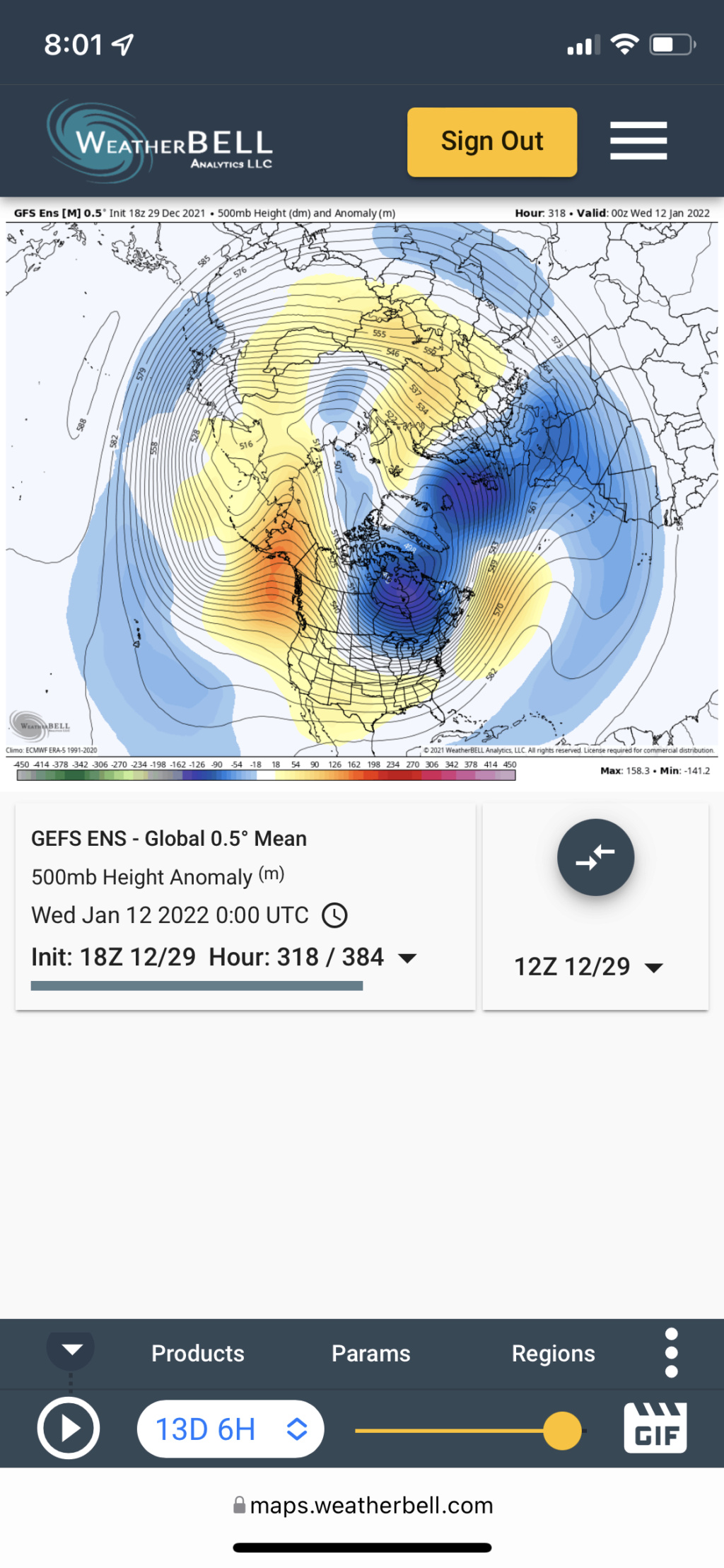
The EURO is having issues with it’s convective relations right now, I think, and I think the GEPS is on the right track overall, but it’s mishandling the Alaskan ridge evolution. But the key things that I’m noticing across the guidance are:
1. Gulf of Alaska low will replace the Aleutian ridge that we’ve had, and therefore be the catalyst to shift the Pacific wave breaking further east (jet extension that mugsy has been focused on).
2. Trough(s) undercutting the ridging and instead of shedding short waves into the tropics, will be allowed to propagate at a higher latitude near and north of Hawaii. When you get a time-mean trough in the Gulf of Alaska/northwest of Hawaii and/or over/east-northeast of Hawaii, that is a very conducive setup to promote and establish time-mean ridging in the WPO, EPO, and PNA domains. This is where I think the GEFS and GEPS look good overall, and the EPS is struggling. Because the EPS has the good trough positions in the Pacific, but it’s not reflecting the what I think the synoptic response should be in the EPO/WPO domains. Therefore, it makes it seem like the trough is shallower over the eastern CONUS than it should be.
3. Cahir’s Connection is now showing up on all three (my 70N/70E ridge that look for as the “anchor”). From this, we should see the renewal of another -NAO attempt down the road, but let’s not put the cart before the horse right now lol
Basis the above, the above image looks the best to me, and I would expect this to continue given all of the discourse to date.
rb924119- Meteorologist

- Posts : 7043
Reputation : 195
Join date : 2013-02-06
Age : 32
Location : Greentown, Pa
 Re: Long Range Discussion 22.0
_________________
Mugs
AKA:King: Snow Weenie
Self Proclaimed
WINTER 2014-15 : 55.12" +.02 for 6 coatings (avg. 35")
WINTER 2015-16 Total - 29.8" (Avg 35")
WINTER 2016-17 : 39.5" so far

amugs- Advanced Forecaster - Mod

- Posts : 15133
Reputation : 213
Join date : 2013-01-07
Age : 54
Location : Hillsdale,NJ
rb924119 likes this post
 Re: Long Range Discussion 22.0
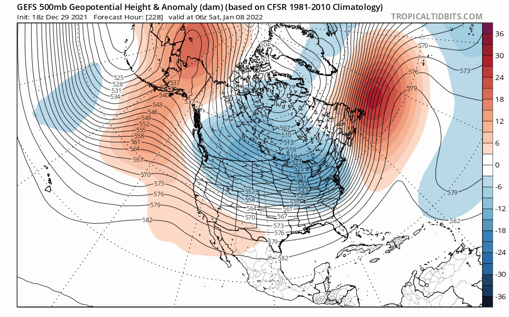
You can see the N PNA erode and thus has been the timeframe rb has been looking at going to a +POS and a - EPO form. Again the MJO phase 7 is a good phase for Jan as is 8 and from the MJO wave in phase 6 moderately in Dec it has caused an + EAMT that will help retract the PAC JET and slow the flow down. The downstream affects will get here 2nd week of Jan. And if it does and Rb call comes to fruition for that time period through till March then we "ALL HAIL rb"!!
_________________
Mugs
AKA:King: Snow Weenie
Self Proclaimed
WINTER 2014-15 : 55.12" +.02 for 6 coatings (avg. 35")
WINTER 2015-16 Total - 29.8" (Avg 35")
WINTER 2016-17 : 39.5" so far

amugs- Advanced Forecaster - Mod

- Posts : 15133
Reputation : 213
Join date : 2013-01-07
Age : 54
Location : Hillsdale,NJ
rb924119, SENJsnowman and phil155 like this post
 Re: Long Range Discussion 22.0
heehaw453- Advanced Forecaster

- Posts : 3916
Reputation : 86
Join date : 2014-01-20
Location : Bedminster Township, PA Elevation 600' ASL
rb924119 likes this post
 Re: Long Range Discussion 22.0

Irish- Pro Enthusiast

- Posts : 788
Reputation : 19
Join date : 2019-01-16
Age : 46
Location : Old Bridge, NJ
rb924119 and phil155 like this post
 Re: Long Range Discussion 22.0
heehaw453 wrote:Gfs still showing a good look for Sunday potential. Still doubt anything comes of it but an entertaining day 4 run nonetheless.
Yeah 00z GFS certainly showed the potential in this time frame. 06z shifted back S&E but there is enough consistency with a workable western ridge and despite both euro and 6zGFS S&E with the surface low, H5 is definitely close enough where just a little shift in timing and or tilt and a result like 00zGFS is certainly plausible. Close enough to cont to keep the ears raised and be on alert, but like you my expectations are certainly in check.
_________________
"In weather and in life, there's no winning and losing; there's only winning and learning."
WINTER 2012/2013 TOTALS 43.65"WINTER 2017/2018 TOTALS 62.85" WINTER 2022/2023 TOTALS 4.9"
WINTER 2013/2014 TOTALS 64.85"WINTER 2018/2019 TOTALS 14.25" WINTER 2023/2024 TOTALS 13.1"
WINTER 2014/2015 TOTALS 71.20"WINTER 2019/2020 TOTALS 6.35"
WINTER 2015/2016 TOTALS 35.00"WINTER 2020/2021 TOTALS 37.75"
WINTER 2016/2017 TOTALS 42.25"WINTER 2021/2022 TOTALS 31.65"

sroc4- Admin

- Posts : 8449
Reputation : 302
Join date : 2013-01-07
Location : Wading River, LI
heehaw453 and phil155 like this post
 Re: Long Range Discussion 22.0
sroc4 wrote:heehaw453 wrote:Gfs still showing a good look for Sunday potential. Still doubt anything comes of it but an entertaining day 4 run nonetheless.
Yeah 00z GFS certainly showed the potential in this time frame. 06z shifted back S&E but there is enough consistency with a workable western ridge and despite both euro and 6zGFS S&E with the surface low, H5 is definitely close enough where just a little shift in timing and or tilt and a result like 00zGFS is certainly plausible. Close enough to cont to keep the ears raised and be on alert, but like you my expectations are certainly in check.
No doubt it's worth interest. If this GFS is right, then coastal areas will be getting something out of this. You have workable western ridge, deep trough starting to tilt negatively, height rises on EC, crashing mid level temps, vigorous energy around the base of trough, good NAO. If you had a 50/50 low it might be showing a darned blizzard.
I also noticed better s/w energy on Euro too, but the trough it not as deep and not tilted the same way. So to me it's about that trough right now. The more it digs and the lower the dam goes, the better the odds. But alas this is the GFS so it may not be right, LOL.

heehaw453- Advanced Forecaster

- Posts : 3916
Reputation : 86
Join date : 2014-01-20
Location : Bedminster Township, PA Elevation 600' ASL
amugs, rb924119 and SENJsnowman like this post
 Re: Long Range Discussion 22.0
heehaw453 wrote:sroc4 wrote:heehaw453 wrote:Gfs still showing a good look for Sunday potential. Still doubt anything comes of it but an entertaining day 4 run nonetheless.
Yeah 00z GFS certainly showed the potential in this time frame. 06z shifted back S&E but there is enough consistency with a workable western ridge and despite both euro and 6zGFS S&E with the surface low, H5 is definitely close enough where just a little shift in timing and or tilt and a result like 00zGFS is certainly plausible. Close enough to cont to keep the ears raised and be on alert, but like you my expectations are certainly in check.
No doubt it's worth interest. If this GFS is right, then coastal areas will be getting something out of this. You have workable western ridge, deep trough starting to tilt negatively, height rises on EC, crashing mid level temps, vigorous energy around the base of trough, good NAO. If you had a 50/50 low it might be showing a darned blizzard.
I also noticed better s/w energy on Euro too, but the trough it not as deep and not tilted the same way. So to me it's about that trough right now. The more it digs and the lower the dam goes, the better the odds. But alas this is the GFS so it may not be right, LOL.
Euro has def come a long way though even over 24hrs. Notice 00z from yesterday vs last nights 00z. What was once a long strung out intense line of progressive vorticity is now trying to consolidate some. Not enough but there is still time. Again ears are perked but not convinced we can come all the way there.


_________________
"In weather and in life, there's no winning and losing; there's only winning and learning."
WINTER 2012/2013 TOTALS 43.65"WINTER 2017/2018 TOTALS 62.85" WINTER 2022/2023 TOTALS 4.9"
WINTER 2013/2014 TOTALS 64.85"WINTER 2018/2019 TOTALS 14.25" WINTER 2023/2024 TOTALS 13.1"
WINTER 2014/2015 TOTALS 71.20"WINTER 2019/2020 TOTALS 6.35"
WINTER 2015/2016 TOTALS 35.00"WINTER 2020/2021 TOTALS 37.75"
WINTER 2016/2017 TOTALS 42.25"WINTER 2021/2022 TOTALS 31.65"

sroc4- Admin

- Posts : 8449
Reputation : 302
Join date : 2013-01-07
Location : Wading River, LI
rb924119 and heehaw453 like this post
 Re: Long Range Discussion 22.0
heehaw453- Advanced Forecaster

- Posts : 3916
Reputation : 86
Join date : 2014-01-20
Location : Bedminster Township, PA Elevation 600' ASL
rb924119 likes this post
 Re: Long Range Discussion 22.0
heehaw453 wrote:Yeah the 12Z GFS has a lot of mid level energy. That 500mb trough needs to kick negative and then it'll capture the mid level energy to give the coastal areas a substantial snowfall. If it doesn't do that, then the energy escapes for the most part OTS and it would be a scraper on most extreme eastern areas. Anytime you see that kind of mid level energy though around an ULL it is intriguing.
For sure. And we all know being in the bulseye at this lead time is usually not ideal. The things that are starting to come into focus are 1) there will be a workable ridge west (which we have already noted. But 2) is that a strom does look to form to our S. Prev Euro runs had no storm, but has clearly trended towards a system forming to the south; in line with the GFS.
Now we just need to get this trough to tilt a little early. I honestly dont think we need negative tilt for a decent event, esp the coastal plain. A neg tilt may cause the G word to come ot, but honestly for now im not even entertaining that. But a neutral or only slight positive tilt is def within reach. 12z GFS was very close. Lets see how Euro looks.
_________________
"In weather and in life, there's no winning and losing; there's only winning and learning."
WINTER 2012/2013 TOTALS 43.65"WINTER 2017/2018 TOTALS 62.85" WINTER 2022/2023 TOTALS 4.9"
WINTER 2013/2014 TOTALS 64.85"WINTER 2018/2019 TOTALS 14.25" WINTER 2023/2024 TOTALS 13.1"
WINTER 2014/2015 TOTALS 71.20"WINTER 2019/2020 TOTALS 6.35"
WINTER 2015/2016 TOTALS 35.00"WINTER 2020/2021 TOTALS 37.75"
WINTER 2016/2017 TOTALS 42.25"WINTER 2021/2022 TOTALS 31.65"

sroc4- Admin

- Posts : 8449
Reputation : 302
Join date : 2013-01-07
Location : Wading River, LI
rb924119, heehaw453, SENJsnowman and phil155 like this post
 Re: Long Range Discussion 22.0

dkodgis- Senior Enthusiast

- Posts : 2672
Reputation : 98
Join date : 2013-12-29
 Re: Long Range Discussion 22.0
amugs wrote:
You can see the N PNA erode and thus has been the timeframe rb has been looking at going to a +POS and a - EPO form. Again the MJO phase 7 is a good phase for Jan as is 8 and from the MJO wave in phase 6 moderately in Dec it has caused an + EAMT that will help retract the PAC JET and slow the flow down. The downstream affects will get here 2nd week of Jan. And if it does and Rb call comes to fruition for that time period through till March then we "ALL HAIL rb"!!
We gotta keep reelin’ mugs, she’s almost at the boat!! We’re almost at the leader!! I can see it now, though:
“It’s gotta be a 20-footer!”
……..
“25……..”
rb924119- Meteorologist

- Posts : 7043
Reputation : 195
Join date : 2013-02-06
Age : 32
Location : Greentown, Pa
 Re: Long Range Discussion 22.0
Irish wrote:rb is brilliant and for me the most trusted weather mind here and that says a lot, as there are some amazing peeps here. Dude puts the time in and when he comes to conclusion or predictions, they're golden for me.
Thanks, Irish. I really appreciate this
Seriously, though, as you said, there are many great forecasters here, often times with varying opinions, and that’s what makes it fun and educational!
rb924119- Meteorologist

- Posts : 7043
Reputation : 195
Join date : 2013-02-06
Age : 32
Location : Greentown, Pa
Irish likes this post
 Re: Long Range Discussion 22.0
rb924119- Meteorologist

- Posts : 7043
Reputation : 195
Join date : 2013-02-06
Age : 32
Location : Greentown, Pa
MattyICE likes this post
 Re: Long Range Discussion 22.0

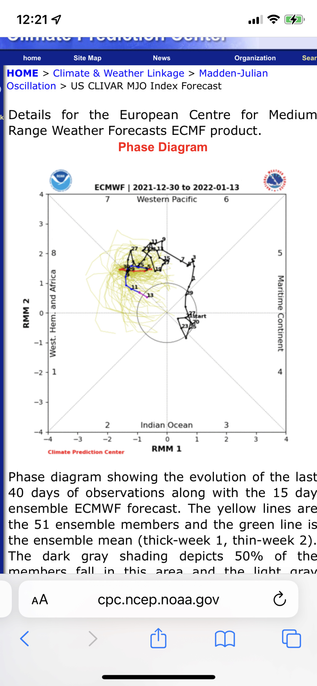
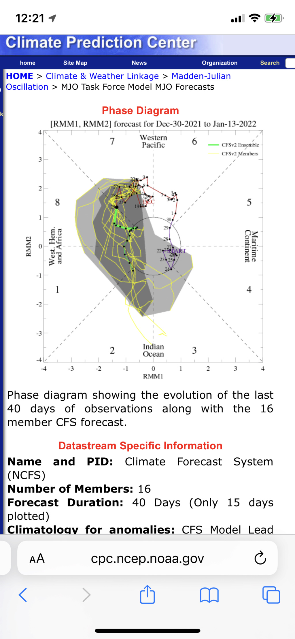
Compared to recent runs, both the EURO and GFS Ensemble are longer and stronger in Phase 8 before returning more briefly but stronger into Phase 7 and then coming back out into Phase 8 with more amplitude. The CFS generally keeps the wave progressing along, though it is known to have a bias for that. In this case, however, I think the CFS evolution is more on track since the other guidance is seemingly headed in that direction. I also like it now because it is aligning with my preconceived ideas.
Regarding the maps, I don’t think last night’s EURO Ensemble is correct in its depiction of the evolution, and even at the end of its run, it began adjusting toward the GFS and GEM Ensembles, which both more or less evolve how I am expecting. On top of that, this should be an approximation of where we are headed based on the interplay between La Niña and the MJO Phase 8:
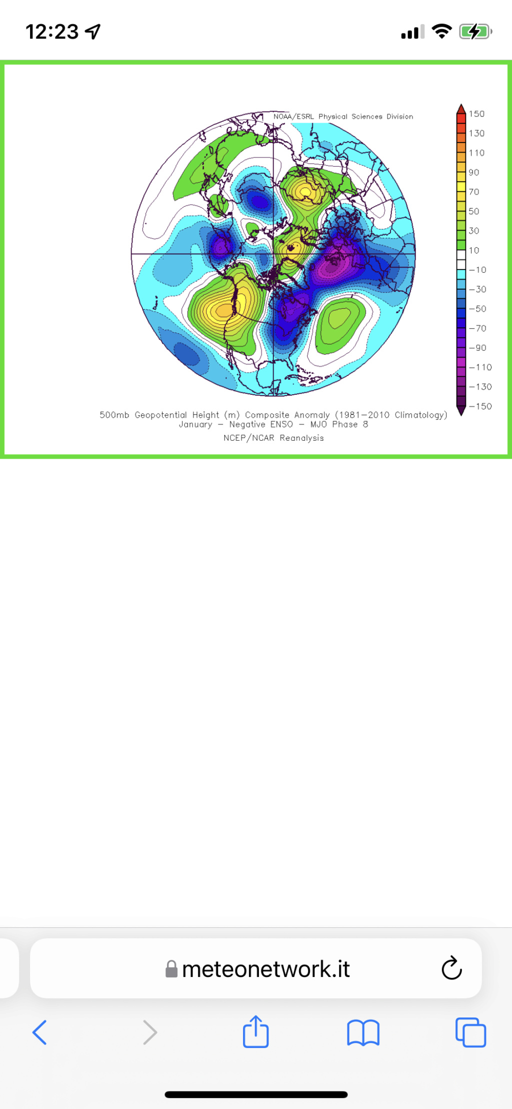
Looks very similar to the GFS and GEM Ensembles, doesn’t it?
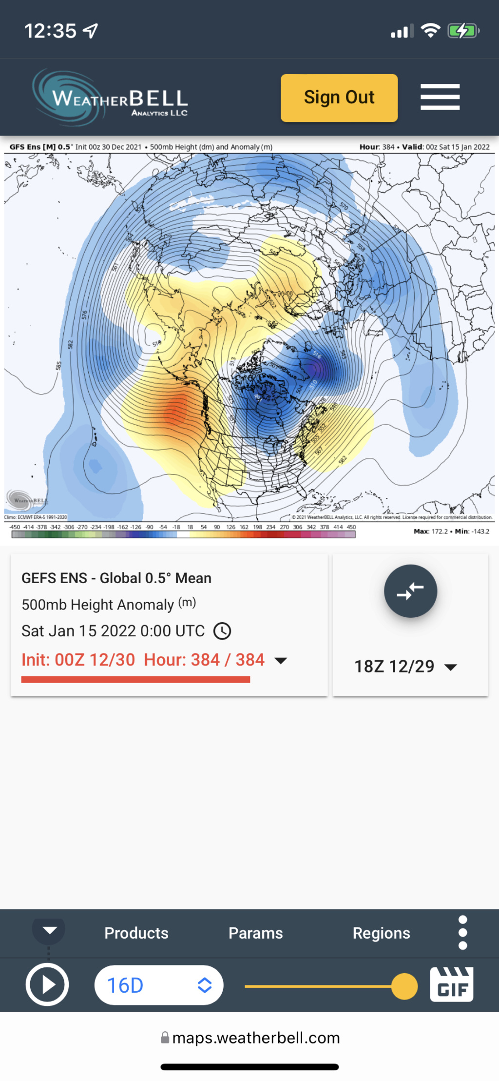
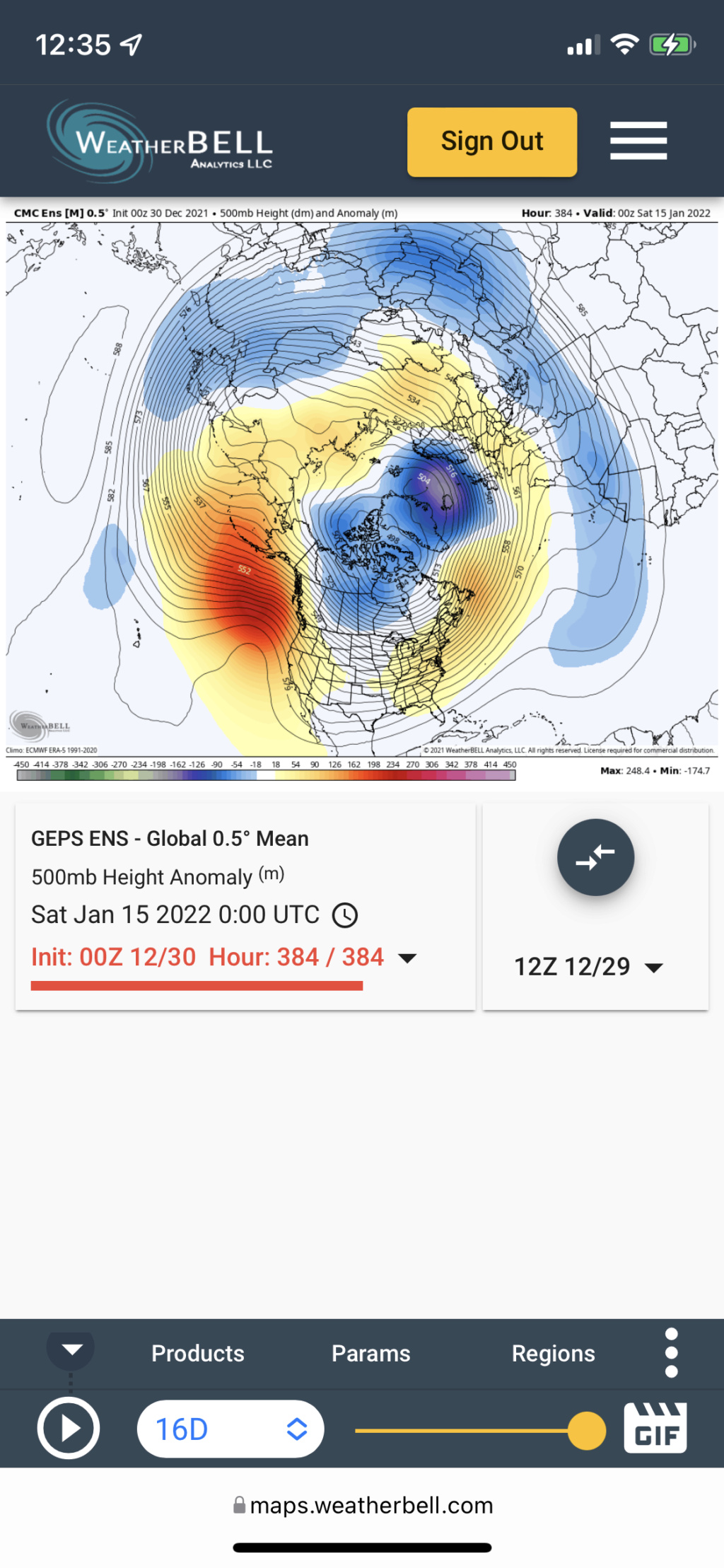
I do think that there’s some room for a slightly further east correction in both of these, which would align very well with the composite, and I think we will see that as we get closer. Just my opinion, though.
rb924119- Meteorologist

- Posts : 7043
Reputation : 195
Join date : 2013-02-06
Age : 32
Location : Greentown, Pa
heehaw453 likes this post
Page 17 of 31 •  1 ... 10 ... 16, 17, 18 ... 24 ... 31

 Home
Home