Long Range Discussion 22.0
+33
skinsfan1177
chief7
WeatherBob
emokid51783
hyde345
jmanley32
dsix85
jaydoy
billg315
lglickman1
CPcantmeasuresnow
Snow88
mmanisca
phil155
weatherwatchermom
Dunnzoo
nutleyblizzard
Radz
Irish
Wheezer
Math23x7
rb924119
SENJsnowman
heehaw453
algae888
aiannone
MattyICE
frank 638
Frank_Wx
docstox12
dkodgis
amugs
sroc4
37 posters
Page 18 of 31
Page 18 of 31 •  1 ... 10 ... 17, 18, 19 ... 24 ... 31
 Re: Long Range Discussion 22.0
Great discussion in here by sroc and heehaw about the possible event a few days from now. I’ve not been paying attention, as all of my focus has been on the extended, but, it would be a nice change of pace for sure haha unfortunately, with the way my schedule will be, I probably won’t have time to chime in, but if I can, I will. If not, I’m sure we’ll have plenty of other opportunities coming up  besides, we’re in good hands with these two
rb924119- Meteorologist

- Posts : 7042
Join date : 2013-02-06
MattyICE likes this post
 Re: Long Range Discussion 22.0
Interesting changes afoot with respect to the MJO forecasts:

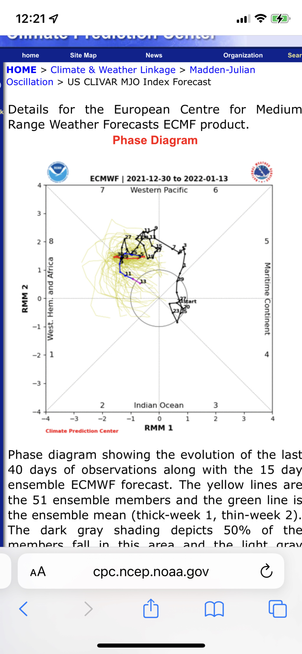
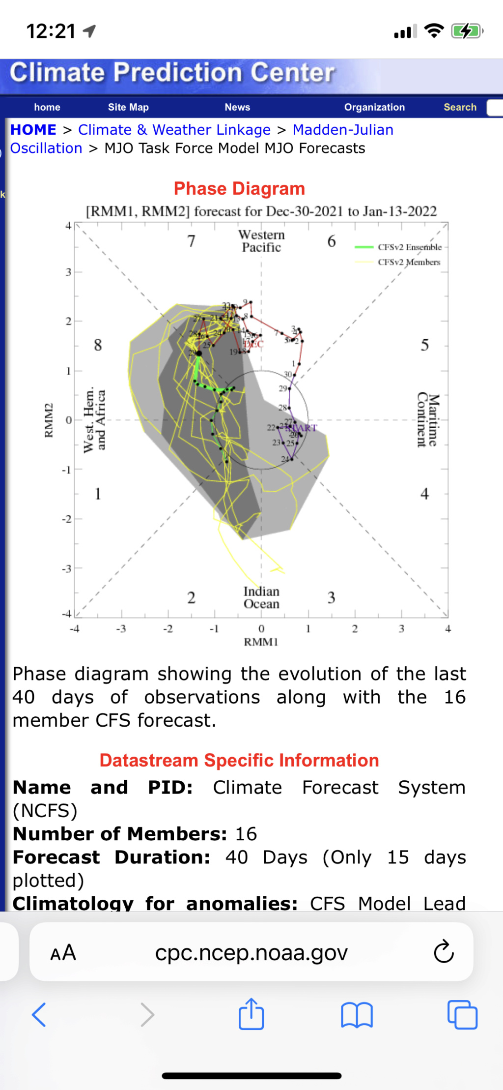
Compared to recent runs, both the EURO and GFS Ensemble are longer and stronger in Phase 8 before returning more briefly but stronger into Phase 7 and then coming back out into Phase 8 with more amplitude. The CFS generally keeps the wave progressing along, though it is known to have a bias for that. In this case, however, I think the CFS evolution is more on track since the other guidance is seemingly headed in that direction. I also like it now because it is aligning with my preconceived ideas.
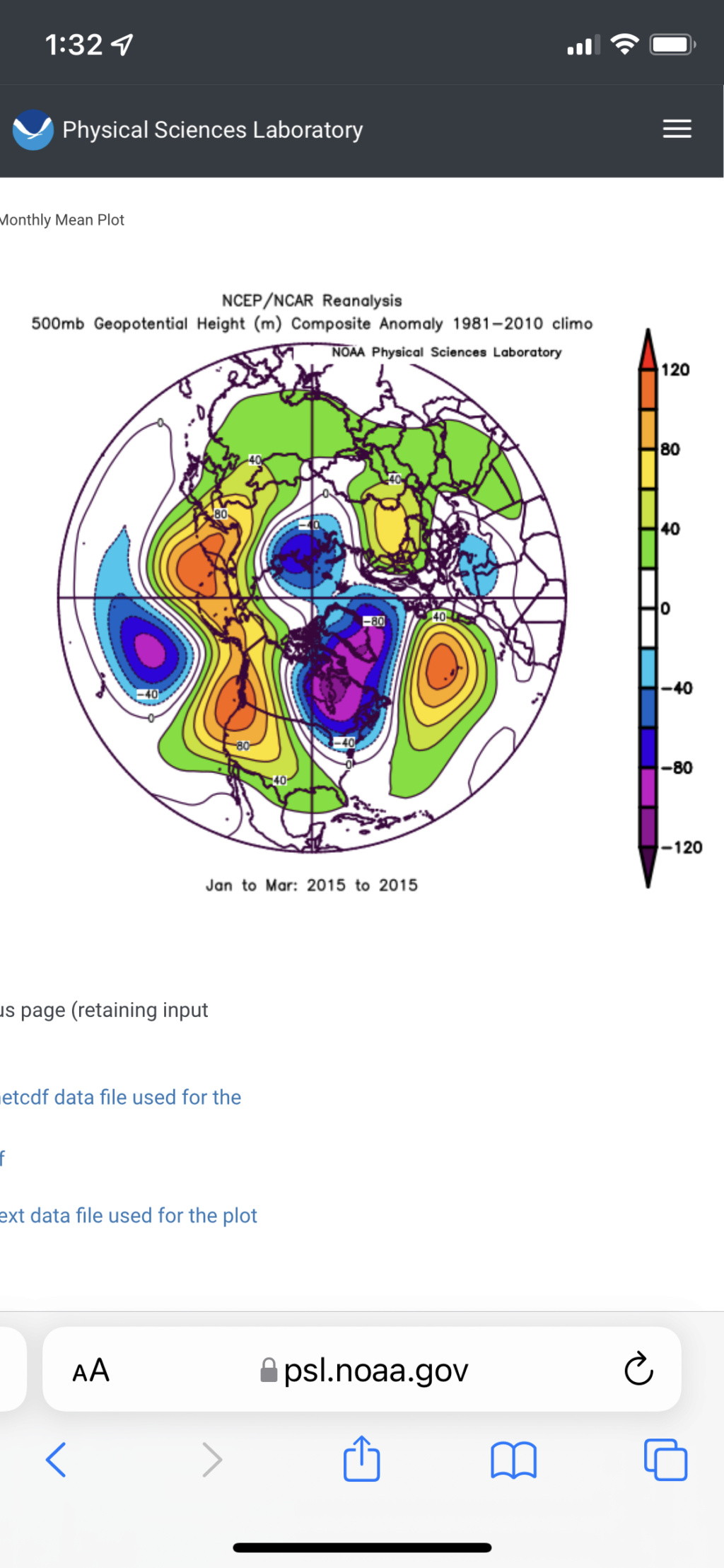
Regarding the maps, I don’t think last night’s EURO Ensemble is correct in its depiction of the evolution, and even at the end of its run, it began adjusting toward the GFS and GEM Ensembles, which both more or less evolve how I am expecting. On top of that, this should be an approximation of where we are headed based on the interplay between La Niña and the MJO Phase 8:
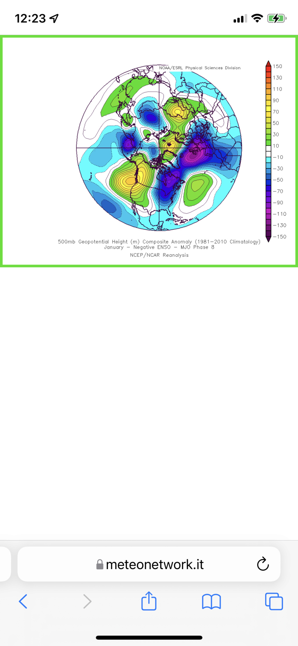
Looks very similar to the GFS and GEM Ensembles, doesn’t it?
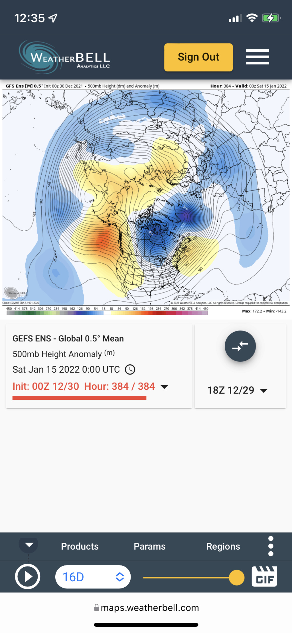
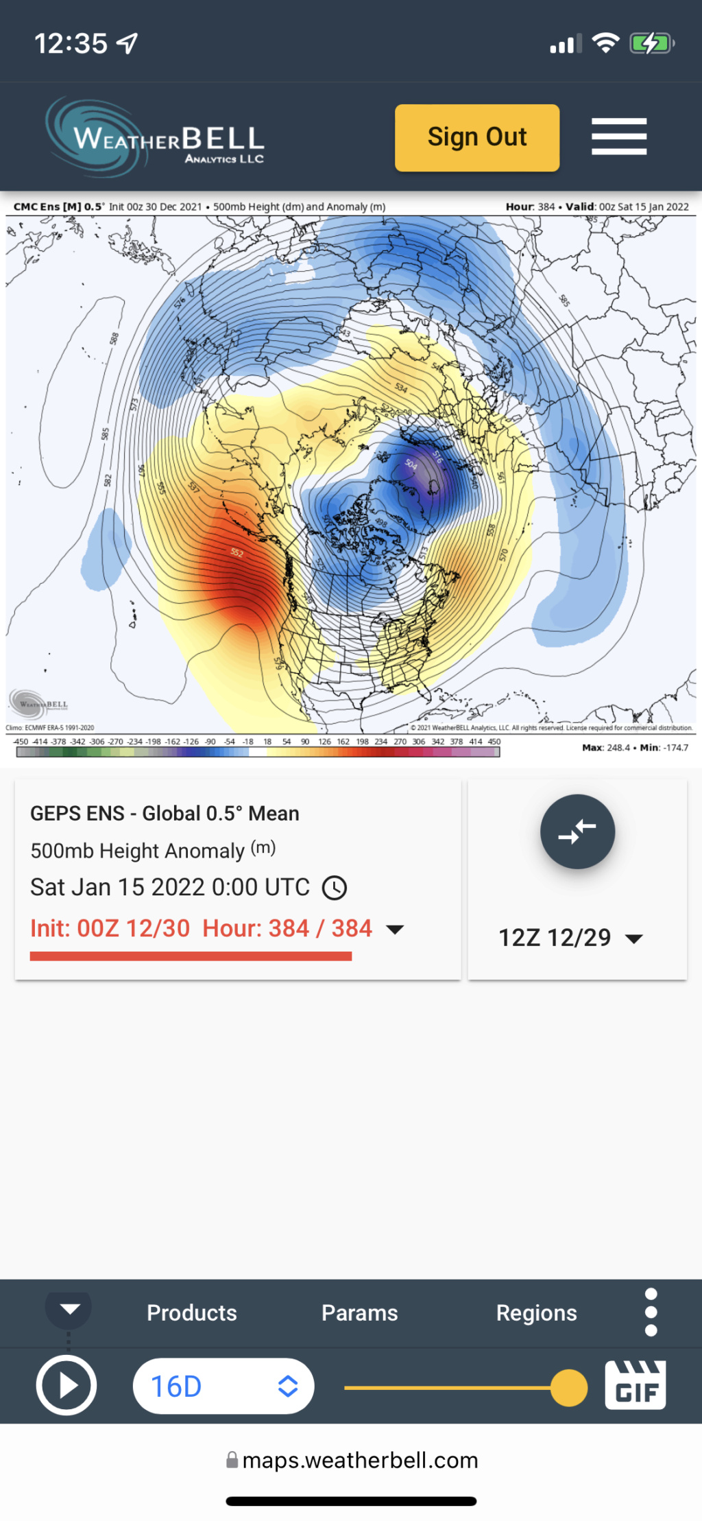
I do think that there’s some room for a slightly further east correction in both of these, which would align very well with the composite, and I think we will see that as we get closer. Just my opinion, though.


Compared to recent runs, both the EURO and GFS Ensemble are longer and stronger in Phase 8 before returning more briefly but stronger into Phase 7 and then coming back out into Phase 8 with more amplitude. The CFS generally keeps the wave progressing along, though it is known to have a bias for that. In this case, however, I think the CFS evolution is more on track since the other guidance is seemingly headed in that direction. I also like it now because it is aligning with my preconceived ideas.
Regarding the maps, I don’t think last night’s EURO Ensemble is correct in its depiction of the evolution, and even at the end of its run, it began adjusting toward the GFS and GEM Ensembles, which both more or less evolve how I am expecting. On top of that, this should be an approximation of where we are headed based on the interplay between La Niña and the MJO Phase 8:

Looks very similar to the GFS and GEM Ensembles, doesn’t it?


I do think that there’s some room for a slightly further east correction in both of these, which would align very well with the composite, and I think we will see that as we get closer. Just my opinion, though.
rb924119- Meteorologist

- Posts : 7042
Join date : 2013-02-06
heehaw453 likes this post
 Re: Long Range Discussion 22.0
rb924119 wrote:Interesting changes afoot with respect to the MJO forecasts:
Compared to recent runs, both the EURO and GFS Ensemble are longer and stronger in Phase 8 before returning more briefly but stronger into Phase 7 and then coming back out into Phase 8 with more amplitude. The CFS generally keeps the wave progressing along, though it is known to have a bias for that. In this case, however, I think the CFS evolution is more on track since the other guidance is seemingly headed in that direction. I also like it now because it is aligning with my preconceived ideas.
Regarding the maps, I don’t think last night’s EURO Ensemble is correct in its depiction of the evolution, and even at the end of its run, it began adjusting toward the GFS and GEM Ensembles, which both more or less evolve how I am expecting. On top of that, this should be an approximation of where we are headed based on the interplay between La Niña and the MJO Phase 8:
Looks very similar to the GFS and GEM Ensembles, doesn’t it?
I do think that there’s some room for a slightly further east correction in both of these, which would align very well with the composite, and I think we will see that as we get closer. Just my opinion, though.
Very 2014/15 look there!
heehaw453- Advanced Forecaster

- Posts : 3916
Reputation : 86
Join date : 2014-01-20
Location : Bedminster Township, PA Elevation 600' ASL
rb924119 likes this post
 Re: Long Range Discussion 22.0
heehaw453 wrote:rb924119 wrote:Interesting changes afoot with respect to the MJO forecasts:
Compared to recent runs, both the EURO and GFS Ensemble are longer and stronger in Phase 8 before returning more briefly but stronger into Phase 7 and then coming back out into Phase 8 with more amplitude. The CFS generally keeps the wave progressing along, though it is known to have a bias for that. In this case, however, I think the CFS evolution is more on track since the other guidance is seemingly headed in that direction. I also like it now because it is aligning with my preconceived ideas.
Regarding the maps, I don’t think last night’s EURO Ensemble is correct in its depiction of the evolution, and even at the end of its run, it began adjusting toward the GFS and GEM Ensembles, which both more or less evolve how I am expecting. On top of that, this should be an approximation of where we are headed based on the interplay between La Niña and the MJO Phase 8:
Looks very similar to the GFS and GEM Ensembles, doesn’t it?
I do think that there’s some room for a slightly further east correction in both of these, which would align very well with the composite, and I think we will see that as we get closer. Just my opinion, though.
Very 2014/15 look there!
Wow, what a memory!! And what a match!!

rb924119- Meteorologist

- Posts : 7042
Reputation : 195
Join date : 2013-02-06
Age : 32
Location : Greentown, Pa
 Re: Long Range Discussion 22.0
Significant storm signal on the GFS and GEM Ensembles 14th-16th, in case anybody was wondering 
rb924119- Meteorologist

- Posts : 7042
Reputation : 195
Join date : 2013-02-06
Age : 32
Location : Greentown, Pa
amugs and Bwtr like this post
 Re: Long Range Discussion 22.0
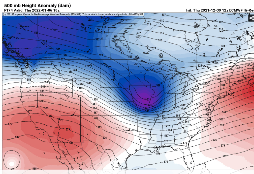
I'm going to go Rayno on here. Snowfall chances usually occur with cold air on the way in and out. After 1/6 we stand to get some decent cold air. There is significant western ridging occurring at that time too. So I would say that is another window. These may not work out, but at least there is something better to look at than a perpetual trough hanging out in PNA land.

heehaw453- Advanced Forecaster

- Posts : 3916
Reputation : 86
Join date : 2014-01-20
Location : Bedminster Township, PA Elevation 600' ASL
rb924119 likes this post
 Re: Long Range Discussion 22.0
That's my call going back 2 or 3rd week NESIS storm rb ^^^.
Also, The Hovmoller maps I will post later but the show the wave going to 7/8 border and then into 8. MJO phase 5/6 did some dirty work for a + EAMT where that warm tropical air hits the massive east Asian mountains and lack of better terms torques the atmosphere above it perturbed it greatly. All that warm air then can cause perturbation in the PV and it also has upstream affects on the PAC JET pattern since it can create Higher Pressures over the region and lower pressures over the Korean Kamchuck Pennisula with HP to its east retracting a anticyclonic break to the jet structure. This then affects everything to its east and above in the Arctic. MJO wave is impossible the tropics help dictate the pattern.
1/3 may kick us off in a crappy pattern. GEFS show a lean at Delmarva region.
33 rain wx

_________________
Mugs
AKA:King: Snow Weenie
Self Proclaimed
WINTER 2014-15 : 55.12" +.02 for 6 coatings (avg. 35")
WINTER 2015-16 Total - 29.8" (Avg 35")
WINTER 2016-17 : 39.5" so far

amugs- Advanced Forecaster - Mod

- Posts : 15133
Reputation : 213
Join date : 2013-01-07
Age : 54
Location : Hillsdale,NJ
rb924119 likes this post
 Re: Long Range Discussion 22.0
heehaw453 wrote:I'm going to go Rayno on here. Snowfall chances usually occur with cold air on the way in and out. After 1/6 we stand to get some decent cold air. There is significant western ridging occurring at that time too. So I would say that is another window. These may not work out, but at least there is something better to look at than a perpetual trough hanging out in PNA land.
Gahhh!! You beat me to it!! Haha I was just looking at this lmao unfortunately, I don’t think that the pattern will be quite ready yet to give us the goods on this one, but central New England and points north will likely do well in my opinion. DEFINITELY bears watching, though, as this is the beginning of the transitional window, and like you said, storms tend accompany these changes. WE TRACK!!
rb924119- Meteorologist

- Posts : 7042
Reputation : 195
Join date : 2013-02-06
Age : 32
Location : Greentown, Pa
 Re: Long Range Discussion 22.0
amugs wrote:That's my call going back 2 or 3rd week NESIS storm rb ^^^.
Also, The Hovmoller maps I will post later but the show the wave going to 7/8 border and then into 8. MJO phase 5/6 did some dirty work for a + EAMT where that warm tropical air hits the massive east Asian mountains and lack of better terms torques the atmosphere above it perturbed it greatly. All that warm air then can cause perturbation in the PV and it also has upstream affects on the PAC JET pattern since it can create Higher Pressures over the region and lower pressures over the Korean Kamchuck Pennisula with HP to its east retracting a anticyclonic break to the jet structure. This then affects everything to its east and above in the Arctic. MJO wave is impossible the tropics help dictate the pattern.
1/3 may kick us off in a crappy pattern. GEFS show a lean at Delmarva region.
33 rain wx
Yeah, we’ve both been bullish on the NESIS threat during that period, and I can’t wait to see the Hovmoellers later, because that timing and progression would be right on cue. Keep reelin’ brother!!
rb924119- Meteorologist

- Posts : 7042
Reputation : 195
Join date : 2013-02-06
Age : 32
Location : Greentown, Pa
heehaw453- Advanced Forecaster

- Posts : 3916
Reputation : 86
Join date : 2014-01-20
Location : Bedminster Township, PA Elevation 600' ASL
CPcantmeasuresnow and rb924119 like this post
 Re: Long Range Discussion 22.0
All it takes is one or two runs. It doesnt matter which model......

_________________
"In weather and in life, there's no winning and losing; there's only winning and learning."
WINTER 2012/2013 TOTALS 43.65"WINTER 2017/2018 TOTALS 62.85" WINTER 2022/2023 TOTALS 4.9"
WINTER 2013/2014 TOTALS 64.85"WINTER 2018/2019 TOTALS 14.25" WINTER 2023/2024 TOTALS 13.1"
WINTER 2014/2015 TOTALS 71.20"WINTER 2019/2020 TOTALS 6.35"
WINTER 2015/2016 TOTALS 35.00"WINTER 2020/2021 TOTALS 37.75"
WINTER 2016/2017 TOTALS 42.25"WINTER 2021/2022 TOTALS 31.65"

sroc4- Admin

- Posts : 8446
Reputation : 302
Join date : 2013-01-07
Location : Wading River, LI
CPcantmeasuresnow, rb924119, crippo84 and heehaw453 like this post
heehaw453- Advanced Forecaster

- Posts : 3916
Reputation : 86
Join date : 2014-01-20
Location : Bedminster Township, PA Elevation 600' ASL
rb924119 likes this post
 Re: Long Range Discussion 22.0
You guys can't possibly be talking about a storm this Sunday as the temps hit 60! No? Looks like a complete wash out all weekend.

Irish- Pro Enthusiast

- Posts : 788
Reputation : 19
Join date : 2019-01-16
Age : 46
Location : Old Bridge, NJ
rb924119 likes this post
heehaw453- Advanced Forecaster

- Posts : 3916
Reputation : 86
Join date : 2014-01-20
Location : Bedminster Township, PA Elevation 600' ASL
sroc4 and rb924119 like this post
 Re: Long Range Discussion 22.0
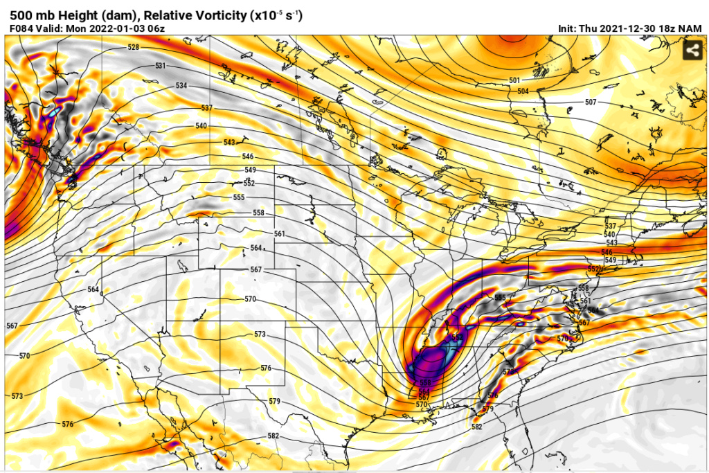
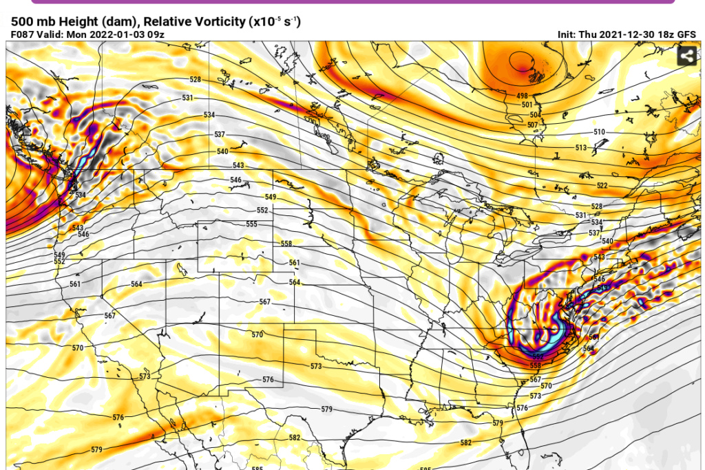
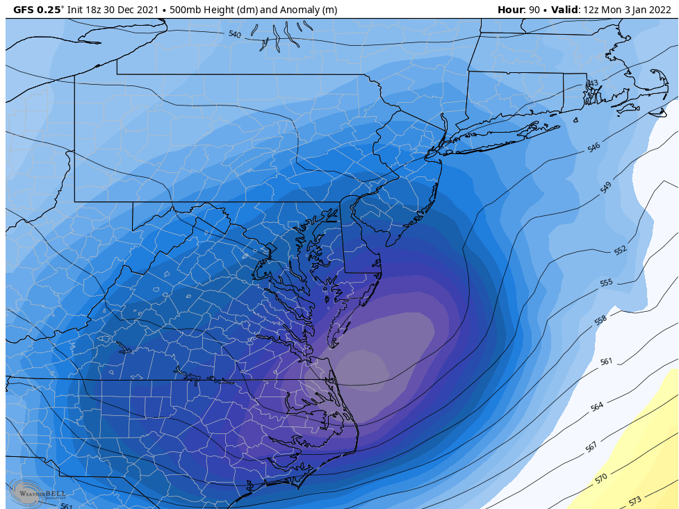
Wow a close miss for Monday’s storm on the GFS. Jeff Smith just mentioned that it needs to be watched. The Nam also shows the threat. I would like to see the Euro jump on board as well, but it was trending that way with the 12z run.

nutleyblizzard- Senior Enthusiast

- Posts : 1963
Reputation : 41
Join date : 2014-01-30
Age : 58
Location : Nutley, new jersey
 Re: Long Range Discussion 22.0
Irish wrote:You guys can't possibly be talking about a storm this Sunday as the temps hit 60! No? Looks like a complete wash out all weekend.
It would likely be Monday am
_________________
"In weather and in life, there's no winning and losing; there's only winning and learning."
WINTER 2012/2013 TOTALS 43.65"WINTER 2017/2018 TOTALS 62.85" WINTER 2022/2023 TOTALS 4.9"
WINTER 2013/2014 TOTALS 64.85"WINTER 2018/2019 TOTALS 14.25" WINTER 2023/2024 TOTALS 13.1"
WINTER 2014/2015 TOTALS 71.20"WINTER 2019/2020 TOTALS 6.35"
WINTER 2015/2016 TOTALS 35.00"WINTER 2020/2021 TOTALS 37.75"
WINTER 2016/2017 TOTALS 42.25"WINTER 2021/2022 TOTALS 31.65"

sroc4- Admin

- Posts : 8446
Reputation : 302
Join date : 2013-01-07
Location : Wading River, LI
Irish likes this post
heehaw453- Advanced Forecaster

- Posts : 3916
Reputation : 86
Join date : 2014-01-20
Location : Bedminster Township, PA Elevation 600' ASL
rb924119 likes this post
 Re: Long Range Discussion 22.0
sroc4 wrote:Irish wrote:You guys can't possibly be talking about a storm this Sunday as the temps hit 60! No? Looks like a complete wash out all weekend.
It would likely be Monday am
Im not quite ready to look at the details at the surface yet, BUT GFS has dew points falling into the upper 20's and low 30's by Sunday eve and then down to mid to low twenties right as the precip moves in during the wee hrs of Monday am. Keep in mind the rain and warm temps from the weekend will drag a cold front through. If dew points do fall similar to what the GFS is showing ahead of the precip then we have alot of room for dynamic/evaporative cooling to take place quickly dropping the surface temps.
This is all preliminary.
_________________
"In weather and in life, there's no winning and losing; there's only winning and learning."
WINTER 2012/2013 TOTALS 43.65"WINTER 2017/2018 TOTALS 62.85" WINTER 2022/2023 TOTALS 4.9"
WINTER 2013/2014 TOTALS 64.85"WINTER 2018/2019 TOTALS 14.25" WINTER 2023/2024 TOTALS 13.1"
WINTER 2014/2015 TOTALS 71.20"WINTER 2019/2020 TOTALS 6.35"
WINTER 2015/2016 TOTALS 35.00"WINTER 2020/2021 TOTALS 37.75"
WINTER 2016/2017 TOTALS 42.25"WINTER 2021/2022 TOTALS 31.65"

sroc4- Admin

- Posts : 8446
Reputation : 302
Join date : 2013-01-07
Location : Wading River, LI
rb924119 likes this post
 Re: Long Range Discussion 22.0
Take a quick peek at the jet streak on the GFS between 300mb & 250mb. Again exact timing and positioning and temp profiles still need a day or two of ironing but that JS might indicate the precip shield should be further N than the surface reflection indicates.
_________________
"In weather and in life, there's no winning and losing; there's only winning and learning."
WINTER 2012/2013 TOTALS 43.65"WINTER 2017/2018 TOTALS 62.85" WINTER 2022/2023 TOTALS 4.9"
WINTER 2013/2014 TOTALS 64.85"WINTER 2018/2019 TOTALS 14.25" WINTER 2023/2024 TOTALS 13.1"
WINTER 2014/2015 TOTALS 71.20"WINTER 2019/2020 TOTALS 6.35"
WINTER 2015/2016 TOTALS 35.00"WINTER 2020/2021 TOTALS 37.75"
WINTER 2016/2017 TOTALS 42.25"WINTER 2021/2022 TOTALS 31.65"

sroc4- Admin

- Posts : 8446
Reputation : 302
Join date : 2013-01-07
Location : Wading River, LI
rb924119 likes this post
 Re: Long Range Discussion 22.0
sroc4 wrote:
Take a quick peek at the jet streak on the GFS between 300mb & 250mb. Again exact timing and positioning and temp profiles still need a day or two of ironing but that JS might indicate the precip shield should be further N than the surface reflection indicates.
Totally agree and good point. The tilt of the trough indicative of much broader precip field too. That's why I was saying not even looking at the surface panels. This look would hammer your area and coastal NJ.
There needs to be some more support though among other guidance. GFS could be playing a cruel trick LOL. Seen it over amplify system before only to pull back within 48 hours. So for now it's a soft sell for me.
heehaw453- Advanced Forecaster

- Posts : 3916
Reputation : 86
Join date : 2014-01-20
Location : Bedminster Township, PA Elevation 600' ASL
sroc4 and rb924119 like this post
 Re: Long Range Discussion 22.0
heehaw453 wrote:sroc4 wrote:
Take a quick peek at the jet streak on the GFS between 300mb & 250mb. Again exact timing and positioning and temp profiles still need a day or two of ironing but that JS might indicate the precip shield should be further N than the surface reflection indicates.
Totally agree and good point. The tilt of the trough indicative of much broader precip field too. That's why I was saying not even looking at the surface panels. This look would hammer your area and coastal NJ.
There needs to be some more support though among other guidance. GFS could be playing a cruel trick LOL. Seen it over amplify system before only to pull back within 48 hours. So for now it's a soft sell for me.
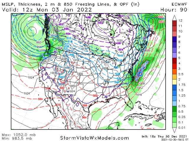
Could not agree more. Until I see the Euro shift I will not get excited. Euro and CMC have been steadfast in keeping it very positively tilted with very little phasing of the energy. As a general rule When the GFS and Euro differ in the track the final solns ends up somewhere in the middle of the cone they create with their differing storm tracks. If that holds true it still will be a swing and miss. 18z euro rolling now.
_________________
"In weather and in life, there's no winning and losing; there's only winning and learning."
WINTER 2012/2013 TOTALS 43.65"WINTER 2017/2018 TOTALS 62.85" WINTER 2022/2023 TOTALS 4.9"
WINTER 2013/2014 TOTALS 64.85"WINTER 2018/2019 TOTALS 14.25" WINTER 2023/2024 TOTALS 13.1"
WINTER 2014/2015 TOTALS 71.20"WINTER 2019/2020 TOTALS 6.35"
WINTER 2015/2016 TOTALS 35.00"WINTER 2020/2021 TOTALS 37.75"
WINTER 2016/2017 TOTALS 42.25"WINTER 2021/2022 TOTALS 31.65"

sroc4- Admin

- Posts : 8446
Reputation : 302
Join date : 2013-01-07
Location : Wading River, LI
rb924119 likes this post
 Re: Long Range Discussion 22.0
The greatest threat to Monday’s storm is yet another anomalous surface low over Alaska pushing into the west coast, turning the flow progressive and disrupting the needed phase at 500mb along the east coast. For now I put chances at 10% for accumulation in Central Park, which is the highest yet this season. Hopefully we can get something to work out. If it doesn’t work out, it’s because of this dreaded -WPO regime we have been in.
Beyond Monday, the -WPO ridge is posed to move north and pinch off over the Arctic. As mentioned already by many on here, this follows a window of opportunity where we can get cross polar flow of arctic air into the central and eastern CONUS from the 5th to the 15th. In my opinion, that is the 10-day window to get something really going. Unfortunately, I’m not as optimistic as others that things turn around late January into February. The way Nina looks, and the overall makeup of the Tropospheric 500mb pattern and lack of coupling with the Stratosphere, I see another -WPO/-PNA pattern trying to take shape late Jan. Still a wayyyy long way to go before we get there. I’ll assess again in ten days or so..
Beyond Monday, the -WPO ridge is posed to move north and pinch off over the Arctic. As mentioned already by many on here, this follows a window of opportunity where we can get cross polar flow of arctic air into the central and eastern CONUS from the 5th to the 15th. In my opinion, that is the 10-day window to get something really going. Unfortunately, I’m not as optimistic as others that things turn around late January into February. The way Nina looks, and the overall makeup of the Tropospheric 500mb pattern and lack of coupling with the Stratosphere, I see another -WPO/-PNA pattern trying to take shape late Jan. Still a wayyyy long way to go before we get there. I’ll assess again in ten days or so..
_________________
_______________________________________________________________________________________________________
CLICK HERE to view NJ Strong Snowstorm Classifications
rb924119 and heehaw453 like this post
 Re: Long Range Discussion 22.0
sroc4 wrote:heehaw453 wrote:sroc4 wrote:
Take a quick peek at the jet streak on the GFS between 300mb & 250mb. Again exact timing and positioning and temp profiles still need a day or two of ironing but that JS might indicate the precip shield should be further N than the surface reflection indicates.
Totally agree and good point. The tilt of the trough indicative of much broader precip field too. That's why I was saying not even looking at the surface panels. This look would hammer your area and coastal NJ.
There needs to be some more support though among other guidance. GFS could be playing a cruel trick LOL. Seen it over amplify system before only to pull back within 48 hours. So for now it's a soft sell for me.
Could not agree more. Until I see the Euro shift I will not get excited. Euro and CMC have been steadfast in keeping it very positively tilted with very little phasing of the energy. As a general rule When the GFS and Euro differ in the track the final solns ends up somewhere in the middle of the cone they create with their differing storm tracks. If that holds true it still will be a swing and miss. 18z euro rolling now.
_________________
_______________________________________________________________________________________________________
CLICK HERE to view NJ Strong Snowstorm Classifications
 Re: Long Range Discussion 22.0
Frank_Wx wrote:sroc4 wrote:heehaw453 wrote:sroc4 wrote:
Take a quick peek at the jet streak on the GFS between 300mb & 250mb. Again exact timing and positioning and temp profiles still need a day or two of ironing but that JS might indicate the precip shield should be further N than the surface reflection indicates.
Totally agree and good point. The tilt of the trough indicative of much broader precip field too. That's why I was saying not even looking at the surface panels. This look would hammer your area and coastal NJ.
There needs to be some more support though among other guidance. GFS could be playing a cruel trick LOL. Seen it over amplify system before only to pull back within 48 hours. So for now it's a soft sell for me.
Could not agree more. Until I see the Euro shift I will not get excited. Euro and CMC have been steadfast in keeping it very positively tilted with very little phasing of the energy. As a general rule When the GFS and Euro differ in the track the final solns ends up somewhere in the middle of the cone they create with their differing storm tracks. If that holds true it still will be a swing and miss. 18z euro rolling now.
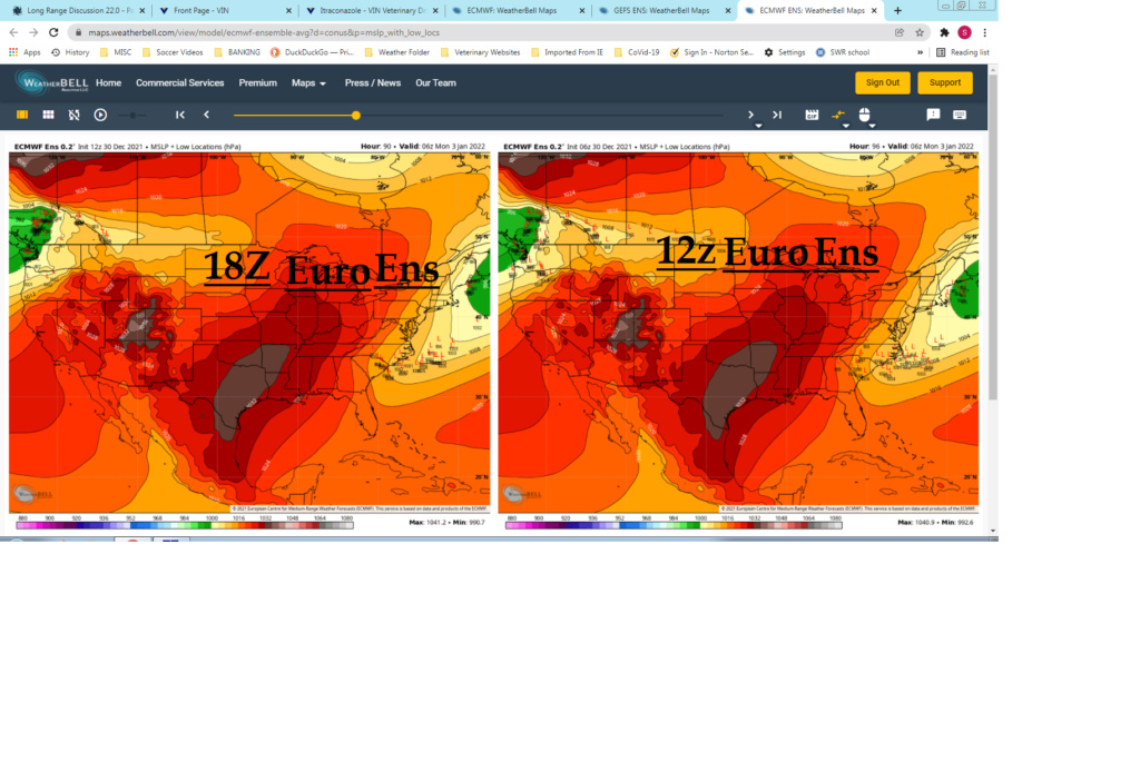
Interestingly enough the Euro ens agrees with its operations. But so does the GFS Ensemble. 18z actually shifted its cluster N on GFS. Battle of the Americans vs the Europeans
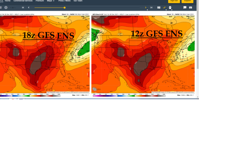
_________________
"In weather and in life, there's no winning and losing; there's only winning and learning."
WINTER 2012/2013 TOTALS 43.65"WINTER 2017/2018 TOTALS 62.85" WINTER 2022/2023 TOTALS 4.9"
WINTER 2013/2014 TOTALS 64.85"WINTER 2018/2019 TOTALS 14.25" WINTER 2023/2024 TOTALS 13.1"
WINTER 2014/2015 TOTALS 71.20"WINTER 2019/2020 TOTALS 6.35"
WINTER 2015/2016 TOTALS 35.00"WINTER 2020/2021 TOTALS 37.75"
WINTER 2016/2017 TOTALS 42.25"WINTER 2021/2022 TOTALS 31.65"

sroc4- Admin

- Posts : 8446
Reputation : 302
Join date : 2013-01-07
Location : Wading River, LI
 Re: Long Range Discussion 22.0
Crap its super small. Sorry I dont have time to fix it.
_________________
"In weather and in life, there's no winning and losing; there's only winning and learning."
WINTER 2012/2013 TOTALS 43.65"WINTER 2017/2018 TOTALS 62.85" WINTER 2022/2023 TOTALS 4.9"
WINTER 2013/2014 TOTALS 64.85"WINTER 2018/2019 TOTALS 14.25" WINTER 2023/2024 TOTALS 13.1"
WINTER 2014/2015 TOTALS 71.20"WINTER 2019/2020 TOTALS 6.35"
WINTER 2015/2016 TOTALS 35.00"WINTER 2020/2021 TOTALS 37.75"
WINTER 2016/2017 TOTALS 42.25"WINTER 2021/2022 TOTALS 31.65"

sroc4- Admin

- Posts : 8446
Reputation : 302
Join date : 2013-01-07
Location : Wading River, LI
 Re: Long Range Discussion 22.0
_________________
Mugs
AKA:King: Snow Weenie
Self Proclaimed
WINTER 2014-15 : 55.12" +.02 for 6 coatings (avg. 35")
WINTER 2015-16 Total - 29.8" (Avg 35")
WINTER 2016-17 : 39.5" so far

amugs- Advanced Forecaster - Mod

- Posts : 15133
Reputation : 213
Join date : 2013-01-07
Age : 54
Location : Hillsdale,NJ
rb924119 likes this post
 Re: Long Range Discussion 22.0
Euro made a small adjustment with separation and a jog N at 18Z
Brooklyn 33nRain Map

Brooklyn 33nRain Map

_________________
Mugs
AKA:King: Snow Weenie
Self Proclaimed
WINTER 2014-15 : 55.12" +.02 for 6 coatings (avg. 35")
WINTER 2015-16 Total - 29.8" (Avg 35")
WINTER 2016-17 : 39.5" so far

amugs- Advanced Forecaster - Mod

- Posts : 15133
Reputation : 213
Join date : 2013-01-07
Age : 54
Location : Hillsdale,NJ
Page 18 of 31 •  1 ... 10 ... 17, 18, 19 ... 24 ... 31
Page 18 of 31
Permissions in this forum:
You cannot reply to topics in this forum
 Home
Home