
 Search
FEB 13th Pre V-Day Storm Part II
Page 4 of 15 •  1, 2, 3, 4, 5 ... 9 ... 15
 ![]()
Re: FEB 13th Pre V-Day Storm Part II
![]() by heehaw453 Mon Feb 12, 2024 10:00 pm
by heehaw453 Mon Feb 12, 2024 10:00 pm

heehaw453- Advanced Forecaster

- Posts : 3906
Join date : 2014-01-20
jmanley32 likes this post

Frank_Wx- Godzilla Seeker

- Posts : 21308
Join date : 2013-01-05 -

Re: FEB 13th Pre V-Day Storm Part II
![]() by heehaw453 Mon Feb 12, 2024 10:03 pm
by heehaw453 Mon Feb 12, 2024 10:03 pm
heehaw453- Advanced Forecaster
- Posts : 3906
Reputation : 86
Join date : 2014-01-20
Location : Bedminster Township, PA Elevation 600' ASL
billg315 and frank 638 like this post
Re: FEB 13th Pre V-Day Storm Part II
![]() by jmanley32 Mon Feb 12, 2024 10:06 pm
by jmanley32 Mon Feb 12, 2024 10:06 pm

jmanley32- Senior Enthusiast

- Posts : 20634
Reputation : 108
Join date : 2013-12-12
Age : 43
Location : Yonkers, NY
Re: FEB 13th Pre V-Day Storm Part II
![]() by billg315 Mon Feb 12, 2024 10:10 pm
by billg315 Mon Feb 12, 2024 10:10 pm
heehaw453 wrote:if folks can get 4-6" out of this with the way the past several winters have gone, it's a big win IMO. Just to get to this point to a quite bit to align.
Definitely true for me. Probably depends where you’re at. Anyone in NJ should be happy with 4-6” out of this because five days ago this was forecast to be just rain. If I were north of NYC I’d probably consider 4-6 (or less) a let down as they were consistently forecast for more than that up until the last 24 hours or so. On the other hand after the last two winters 4-6” anywhere should probably just be taken as a positive.

billg315- Advanced Forecaster - Mod

- Posts : 4530
Reputation : 185
Join date : 2015-01-24
Age : 50
Location : Flemington, NJ
heehaw453 likes this post
Re: FEB 13th Pre V-Day Storm Part II
![]() by amugs Mon Feb 12, 2024 10:12 pm
by amugs Mon Feb 12, 2024 10:12 pm

_________________
Mugs
AKA:King: Snow Weenie
Self Proclaimed
WINTER 2014-15 : 55.12" +.02 for 6 coatings (avg. 35")
WINTER 2015-16 Total - 29.8" (Avg 35")
WINTER 2016-17 : 39.5" so far

amugs- Advanced Forecaster - Mod
- Posts : 15127
Reputation : 213
Join date : 2013-01-07
Age : 54
Location : Hillsdale,NJ
jmanley32, Artingerb and silentwreck like this post
Re: FEB 13th Pre V-Day Storm Part II
![]() by heehaw453 Mon Feb 12, 2024 10:15 pm
by heehaw453 Mon Feb 12, 2024 10:15 pm

heehaw453- Advanced Forecaster
- Posts : 3906
Reputation : 86
Join date : 2014-01-20
Location : Bedminster Township, PA Elevation 600' ASL
Re: FEB 13th Pre V-Day Storm Part II
![]() by Frank_Wx Mon Feb 12, 2024 10:19 pm
by Frank_Wx Mon Feb 12, 2024 10:19 pm
jmanley32 wrote:Frank wheres your final call?
Here

Ultimately decided I do have the right maxima (though isolated 10-11" spots not out of question). I just had to extend the zone further west-northwest to account for better ratios and frontogenesis in those areas than I initially thought.
_________________
_______________________________________________________________________________________________________
CLICK HERE to view NJ Strong Snowstorm Classifications

Frank_Wx- Godzilla Seeker
- Posts : 21308
Reputation : 328
Join date : 2013-01-05
Age : 32
Location : Jersey City, NJ -
heehaw453, JT33 and NJBear like this post
Re: FEB 13th Pre V-Day Storm Part II
![]() by NJBear Mon Feb 12, 2024 10:22 pm
by NJBear Mon Feb 12, 2024 10:22 pm
NWS Discussion
Here's my prediction. Wed morning we'll seen massive amounts of Ice Cement.

NJBear- Posts : 39
Reputation : 0
Join date : 2024-01-06
Re: FEB 13th Pre V-Day Storm Part II
![]() by Frank_Wx Mon Feb 12, 2024 10:30 pm
by Frank_Wx Mon Feb 12, 2024 10:30 pm
_________________
_______________________________________________________________________________________________________
CLICK HERE to view NJ Strong Snowstorm Classifications
Frank_Wx- Godzilla Seeker
- Posts : 21308
Reputation : 328
Join date : 2013-01-05
Age : 32
Location : Jersey City, NJ -
jmanley32 and silentwreck like this post
Re: FEB 13th Pre V-Day Storm Part II
![]() by jmanley32 Mon Feb 12, 2024 10:34 pm
by jmanley32 Mon Feb 12, 2024 10:34 pm
jmanley32- Senior Enthusiast
- Posts : 20634
Reputation : 108
Join date : 2013-12-12
Age : 43
Location : Yonkers, NY
Re: FEB 13th Pre V-Day Storm Part II
![]() by Frank_Wx Mon Feb 12, 2024 10:37 pm
by Frank_Wx Mon Feb 12, 2024 10:37 pm
_________________
_______________________________________________________________________________________________________
CLICK HERE to view NJ Strong Snowstorm Classifications
Frank_Wx- Godzilla Seeker
- Posts : 21308
Reputation : 328
Join date : 2013-01-05
Age : 32
Location : Jersey City, NJ -
billg315 likes this post
Re: FEB 13th Pre V-Day Storm Part II
![]() by Frank_Wx Mon Feb 12, 2024 10:39 pm
by Frank_Wx Mon Feb 12, 2024 10:39 pm
_________________
_______________________________________________________________________________________________________
CLICK HERE to view NJ Strong Snowstorm Classifications
Frank_Wx- Godzilla Seeker
- Posts : 21308
Reputation : 328
Join date : 2013-01-05
Age : 32
Location : Jersey City, NJ -
Artingerb likes this post
Re: FEB 13th Pre V-Day Storm Part II
![]() by emokid51783 Mon Feb 12, 2024 10:40 pm
by emokid51783 Mon Feb 12, 2024 10:40 pm
jmanley32 wrote:From mt. Holly disco..Sheesh 95 coridor 1 to 4 inches...wow does that include nyc arwa or is that 95 along jersey heading south? Does upton have similar thoughts?
It's from holly, there are higher amounts north of -195.
emokid51783- Posts : 144
Reputation : 5
Join date : 2013-12-12
Age : 41
Location : Jersey City Heights, NJ
Re: FEB 13th Pre V-Day Storm Part II
![]() by jmanley32 Mon Feb 12, 2024 10:41 pm
by jmanley32 Mon Feb 12, 2024 10:41 pm
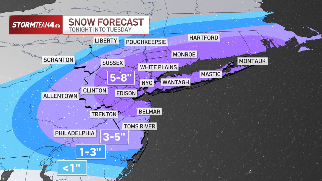
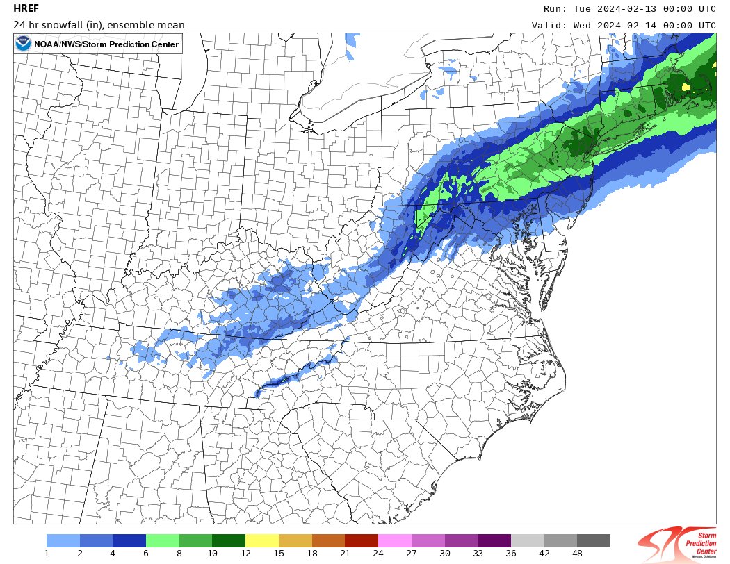
SHORT TERM /6 AM TUESDAY MORNING THROUGH TUESDAY NIGHT/...
* Winter storm to impact the area on Tuesday.
* Winter storm warnings issued for NYC metro and Long Island,
where there is higher confidence in at least 6 inches of
snowfall.
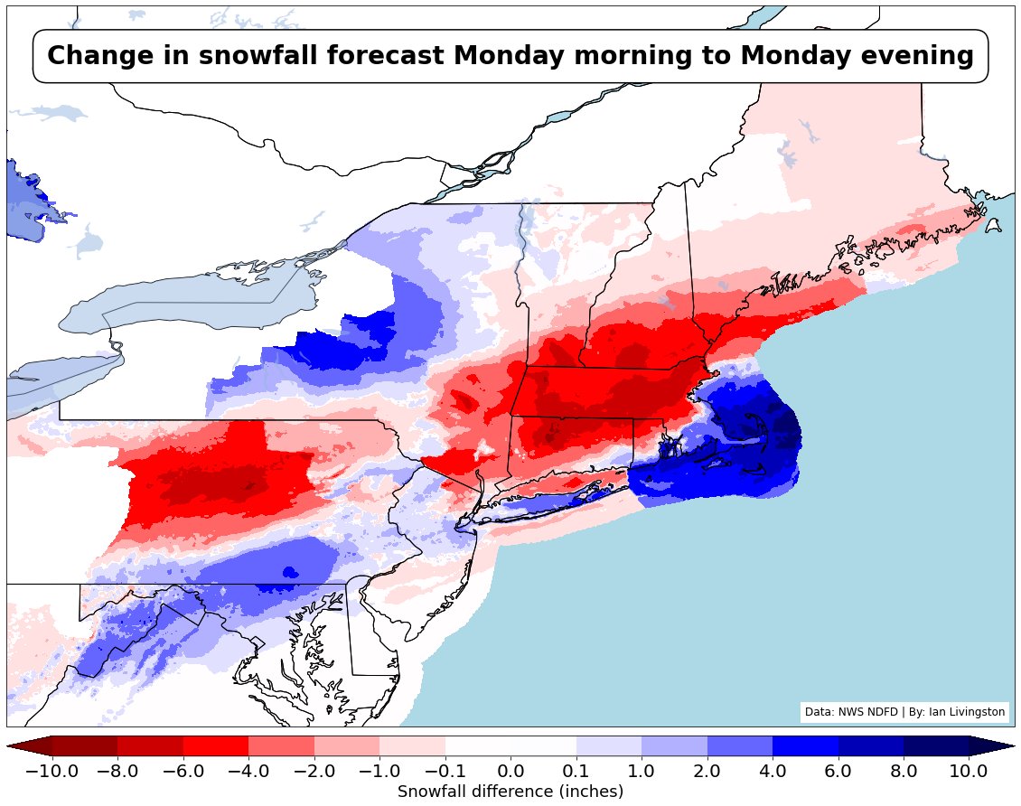
* Guidance continues to trend south. Forecast was originally
based on the 12Z GFS/NAM but made some last-minute changes
based on the 12Z ECMWF/NAM. This could put the metro area and
Long Island more under the axis of higher QPF, with lesser
amts north/west of NYC than originally anticipated.
Model guidance has continued to trend south, with the 18Z
ECMWF/NAM showing a tad less phasing with a northern stream
shortwave trough moving through the Great Lakes. This shift
should lead to lower snowfall amts quite a bit across the
interior, and put the axis of highest QPF either right over
the NYC metro area/Long Island or just south. At the last minute
blended the 12Z ECMWF with the 12Z GFS/NAM which were farther
north. Did not change headlines inland but lowered snowfall amts
to the 6-9 inches range across the interior, and if the
southward trend continues it is possible that northern areas may
less less than 6 inches of snowfall.
Meanwhile confidence has increased enough in higher snowfall
totals for the NYC metro and Long Island to upgrade watches to
warnings for those areas. Amts will be in the 4-7 inch range
around the NYC metro area were blyr temps will remain a little
warmer than areas to the NW and also across Long Island. Per
earlier forecasts of favorable deformation/frontogenetic
forcing near the coast and negative EPV* atop the frontogenetic
layer, there could be some slantwise instability and perhaps
some isolated thunder as the heaviest precip moves across in the
morning.
QPF of 1.00-1.25 inches expected only across the NYC metro area
and Long Island, with lesser amts of 3/4 to 1 inch to the north.
Snow ratios at the coast will likely be low at the onset, but
then increase as the snow becomes heavy (with rates at least
1-2 inches/hour) and low level winds become more northerly.
In addition, NE-N winds at the height of the storm will gust to
30-40 mph, strongest along the coast. This could further
restrict visibilities. However, with the wet nature of the
snow, blowing snow should be at a minimum and any blizzard-like
conditions should be short-lived.
Last edited by jmanley32 on Mon Feb 12, 2024 10:43 pm; edited 2 times in total
jmanley32- Senior Enthusiast
- Posts : 20634
Reputation : 108
Join date : 2013-12-12
Age : 43
Location : Yonkers, NY
Re: FEB 13th Pre V-Day Storm Part II
![]() by Frank_Wx Mon Feb 12, 2024 10:41 pm
by Frank_Wx Mon Feb 12, 2024 10:41 pm
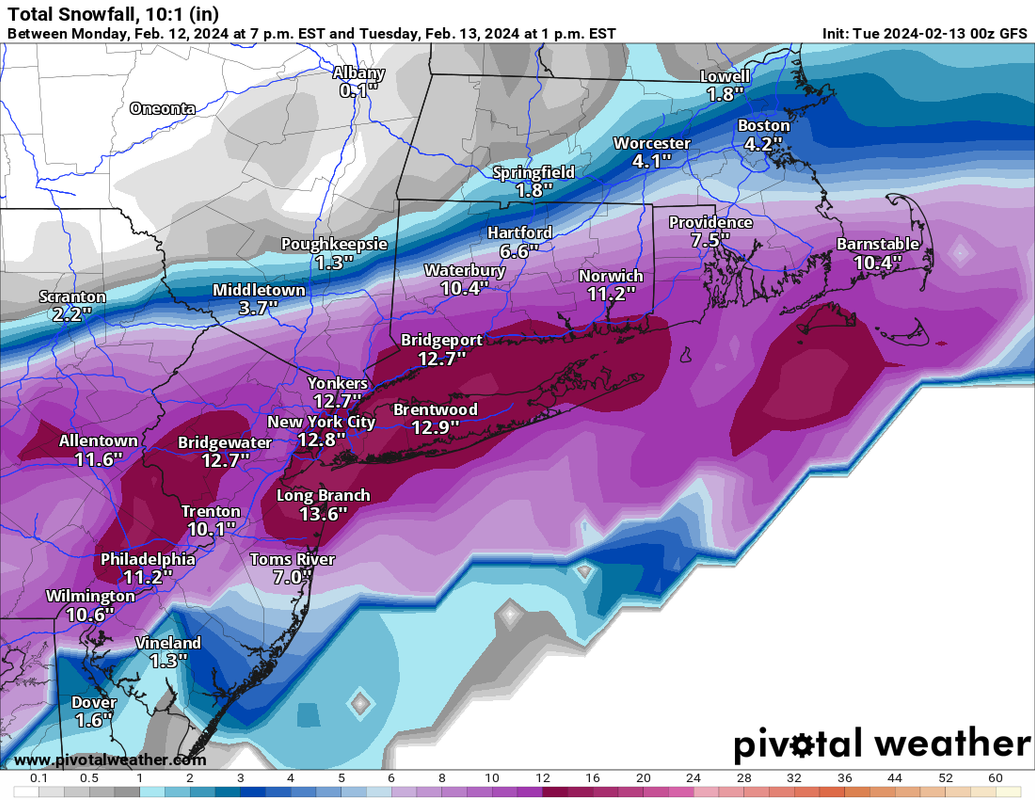
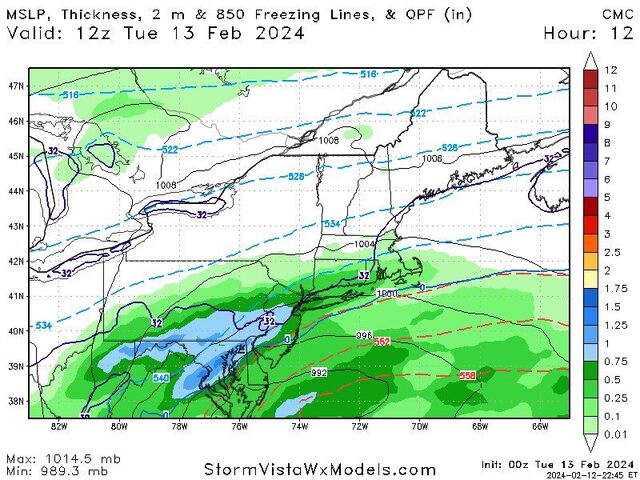
Can't believe how aggressive this model has been. Still tries to output Godzilla-like amounts over a widespread area. Just not buying it
_________________
_______________________________________________________________________________________________________
CLICK HERE to view NJ Strong Snowstorm Classifications
Frank_Wx- Godzilla Seeker
- Posts : 21308
Reputation : 328
Join date : 2013-01-05
Age : 32
Location : Jersey City, NJ -
Irish likes this post
Re: FEB 13th Pre V-Day Storm Part II
![]() by Irish Mon Feb 12, 2024 10:42 pm
by Irish Mon Feb 12, 2024 10:42 pm

Irish- Pro Enthusiast

- Posts : 788
Reputation : 19
Join date : 2019-01-16
Age : 46
Location : Old Bridge, NJ
Re: FEB 13th Pre V-Day Storm Part II
![]() by Frank_Wx Mon Feb 12, 2024 10:43 pm
by Frank_Wx Mon Feb 12, 2024 10:43 pm

_________________
_______________________________________________________________________________________________________
CLICK HERE to view NJ Strong Snowstorm Classifications
Frank_Wx- Godzilla Seeker
- Posts : 21308
Reputation : 328
Join date : 2013-01-05
Age : 32
Location : Jersey City, NJ -
Re: FEB 13th Pre V-Day Storm Part II
![]() by aiannone Mon Feb 12, 2024 10:44 pm
by aiannone Mon Feb 12, 2024 10:44 pm
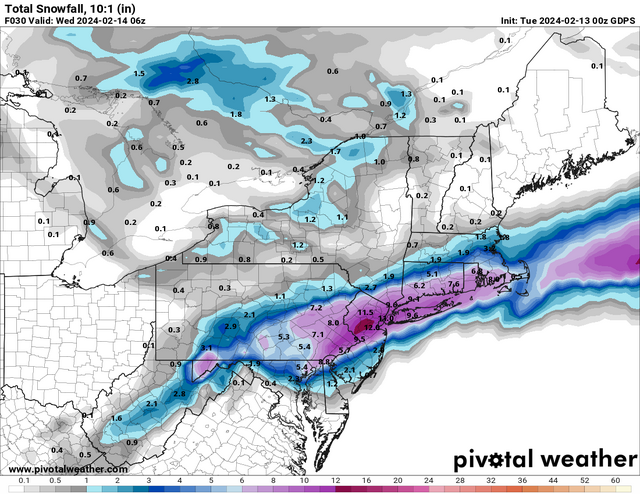
Frank_Wx wrote:00z GFS kuchera I can buy
Not bad. Damn this was a tough go for the Boston weenies.

aiannone- Senior Enthusiast - Mod
- Posts : 4822
Reputation : 92
Join date : 2013-01-07
Location : Saint James, LI (Northwest Suffolk Co.)
Re: FEB 13th Pre V-Day Storm Part II
![]() by NJBear Mon Feb 12, 2024 10:44 pm
by NJBear Mon Feb 12, 2024 10:44 pm
NJBear- Posts : 39
Reputation : 0
Join date : 2024-01-06
Re: FEB 13th Pre V-Day Storm Part II
![]() by Frank_Wx Mon Feb 12, 2024 10:44 pm
by Frank_Wx Mon Feb 12, 2024 10:44 pm
_________________
_______________________________________________________________________________________________________
CLICK HERE to view NJ Strong Snowstorm Classifications
Frank_Wx- Godzilla Seeker
- Posts : 21308
Reputation : 328
Join date : 2013-01-05
Age : 32
Location : Jersey City, NJ -
Re: FEB 13th Pre V-Day Storm Part II
![]() by jmanley32 Mon Feb 12, 2024 10:44 pm
by jmanley32 Mon Feb 12, 2024 10:44 pm
jmanley32- Senior Enthusiast
- Posts : 20634
Reputation : 108
Join date : 2013-12-12
Age : 43
Location : Yonkers, NY
Re: FEB 13th Pre V-Day Storm Part II
![]() by Frank_Wx Mon Feb 12, 2024 10:45 pm
by Frank_Wx Mon Feb 12, 2024 10:45 pm
_________________
_______________________________________________________________________________________________________
CLICK HERE to view NJ Strong Snowstorm Classifications
Frank_Wx- Godzilla Seeker
- Posts : 21308
Reputation : 328
Join date : 2013-01-05
Age : 32
Location : Jersey City, NJ -
jmanley32 and silentwreck like this post
Re: FEB 13th Pre V-Day Storm Part II
![]() by aiannone Mon Feb 12, 2024 10:46 pm
by aiannone Mon Feb 12, 2024 10:46 pm

_________________
-Alex Iannone-
aiannone- Senior Enthusiast - Mod
- Posts : 4822
Reputation : 92
Join date : 2013-01-07
Location : Saint James, LI (Northwest Suffolk Co.)
weatherwatchermom likes this post
Re: FEB 13th Pre V-Day Storm Part II
![]() by billg315 Mon Feb 12, 2024 10:47 pm
by billg315 Mon Feb 12, 2024 10:47 pm
billg315- Advanced Forecaster - Mod
- Posts : 4530
Reputation : 185
Join date : 2015-01-24
Age : 50
Location : Flemington, NJ
Re: FEB 13th Pre V-Day Storm Part II
![]() by Frank_Wx Mon Feb 12, 2024 10:49 pm
by Frank_Wx Mon Feb 12, 2024 10:49 pm
_________________
_______________________________________________________________________________________________________
CLICK HERE to view NJ Strong Snowstorm Classifications
Frank_Wx- Godzilla Seeker
- Posts : 21308
Reputation : 328
Join date : 2013-01-05
Age : 32
Location : Jersey City, NJ -
essexcountypete and Irish like this post
Re: FEB 13th Pre V-Day Storm Part II
![]() by Frank_Wx Mon Feb 12, 2024 10:53 pm
by Frank_Wx Mon Feb 12, 2024 10:53 pm

_________________
_______________________________________________________________________________________________________
CLICK HERE to view NJ Strong Snowstorm Classifications
Frank_Wx- Godzilla Seeker
- Posts : 21308
Reputation : 328
Join date : 2013-01-05
Age : 32
Location : Jersey City, NJ -
essexcountypete and Irish like this post
Page 4 of 15 • 1, 2, 3, 4, 5 ... 9 ... 15 ![]()
|
|
|