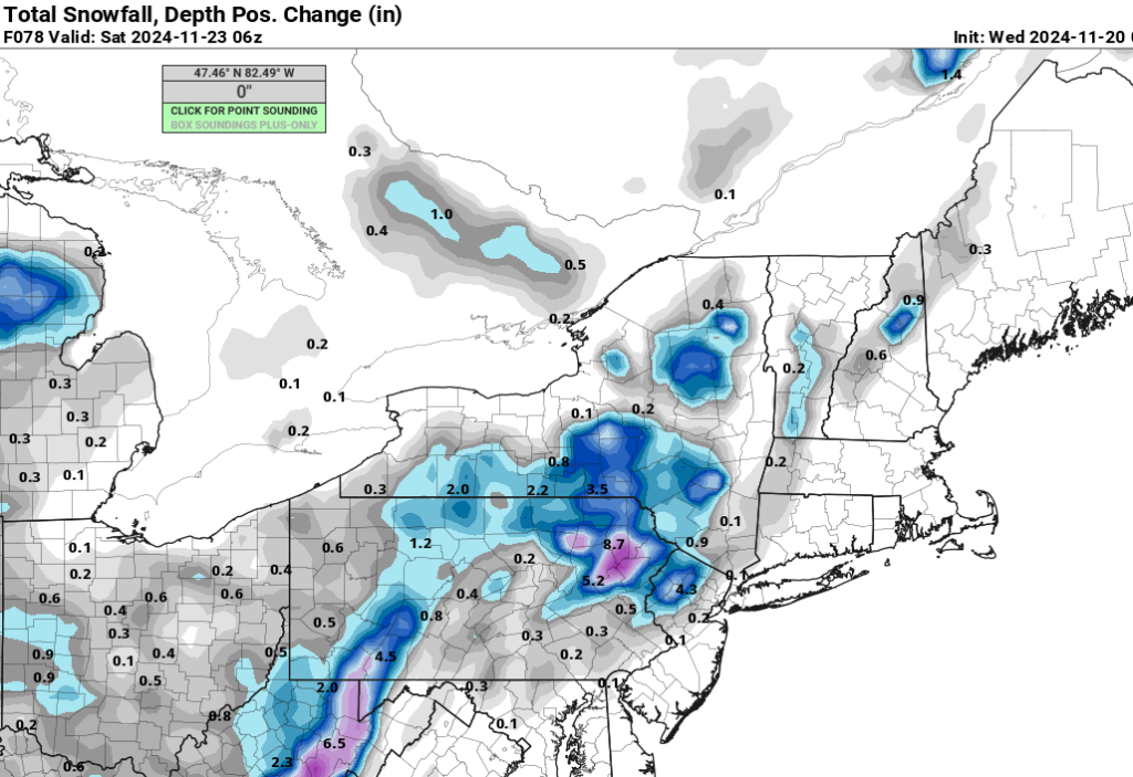
First Snow of the Season?!
 First Snow of the Season?!
Right now, my thinking is the secondary forms at or inside the 40/70 benchmark. Normally this is considered a good thing for coastal areas to see some snow, but not in this type of a setup where the primary ULL is well to our N&W. See below.

This location of the 500mb ULL normally keeps our boundary level temperatures too warm. However, some guidance has the mid center doing a loop - thanks to the blocking aloft - south of NYC and going back off the coast. This will make things very interesting for those N&W of NYC. Ultimately, I think the setup for accumulating snow along the coast is not a great one, but perhaps our first look of snow falling (and maybe even at a good clip at some point) is in the cards. It does seem like those in peak elevations are in for a nice accumulation if everything holds as is right now. Let’s see what happens!
_________________
_______________________________________________________________________________________________________
CLICK HERE to view NJ Strong Snowstorm Classifications
sroc4, docstox12, CPcantmeasuresnow, kalleg, rb924119, nancy-j-s, weatherwatchermom and like this post
 Re: First Snow of the Season?!

hyde345- Pro Enthusiast

- Posts : 1083
Reputation : 48
Join date : 2013-01-08
Location : Hyde Park, NY
kalleg, rb924119, nancy-j-s and weatherwatchermom like this post
 Re: First Snow of the Season?!
kalleg- Posts : 158
Reputation : 2
Join date : 2013-01-15
Location : New Hope, PA
kalleg, rb924119, nancy-j-s, weatherwatchermom and frank 638 like this post
 Re: First Snow of the Season?!
_________________
_______________________________________________________________________________________________________
CLICK HERE to view NJ Strong Snowstorm Classifications
kalleg, nancy-j-s and weatherwatchermom like this post
 Re: First Snow of the Season?!
hyde345 wrote:Elevation is going to play a big role in who gets any real accumulations. Looks to me like NW NJ, eastern PA and the Catskills could see some decent accums.
NWS so far agrees with you.Eastern PA has WSW up for 3 to 7 inches.My forecast here has shifted pretty much to an all rain event in Monroe NY.Will welcome anything to reduce the wildfire risk.

docstox12- Wx Statistician Guru

- Posts : 8609
Reputation : 222
Join date : 2013-01-07
Age : 74
Location : Monroe NY
kalleg and nancy-j-s like this post
 Re: First Snow of the Season?!
heehaw453- Advanced Forecaster

- Posts : 3926
Reputation : 86
Join date : 2014-01-20
Location : Bedminster Township, PA Elevation 600' ASL
rb924119 likes this post
 Re: First Snow of the Season?!
_________________
_______________________________________________________________________________________________________
CLICK HERE to view NJ Strong Snowstorm Classifications
rb924119 and nancy-j-s like this post
jurzdevil- Posts : 9
Reputation : 0
Join date : 2024-01-07
Location : Andover, NJ
nancy-j-s likes this post
 Re: First Snow of the Season?!
_________________
"In weather and in life, there's no winning and losing; there's only winning and learning."
WINTER 2012/2013 TOTALS 43.65"WINTER 2017/2018 TOTALS 62.85" WINTER 2022/2023 TOTALS 4.9"
WINTER 2013/2014 TOTALS 64.85"WINTER 2018/2019 TOTALS 14.25" WINTER 2023/2024 TOTALS 13.1"
WINTER 2014/2015 TOTALS 71.20"WINTER 2019/2020 TOTALS 6.35" WINTER 2024/2025 TOTALS 0.00
WINTER 2015/2016 TOTALS 35.00"WINTER 2020/2021 TOTALS 37.75"
WINTER 2016/2017 TOTALS 42.25"WINTER 2021/2022 TOTALS 31.65"

sroc4- Admin

- Posts : 8457
Reputation : 302
Join date : 2013-01-07
Location : Wading River, LI
nancy-j-s likes this post
 Re: First Snow of the Season?!

billg315- Advanced Forecaster - Mod

- Posts : 4553
Reputation : 185
Join date : 2015-01-24
Age : 50
Location : Flemington, NJ
docstox12, kalleg, rb924119 and nancy-j-s like this post
 Re: First Snow of the Season?!
billg315 wrote:I have to say, it is fascinating the gap between what some models are showing and what the public forecasts are. There are models showing several inches of snow, if not a foot, in areas where the public forecasts are for all (or mostly all rain). In those particular areas someone (or something in the case of the models) will be very wrong - or at least late to the party.
Yea…
Snow maps don’t do well with elevation events. Take them with a massive grain of salt. It’s going to be a tricky forecast regardless.
_________________
_______________________________________________________________________________________________________
CLICK HERE to view NJ Strong Snowstorm Classifications
docstox12, kalleg, nancy-j-s and billg315 like this post
 Re: First Snow of the Season?!

billg315- Advanced Forecaster - Mod

- Posts : 4553
Reputation : 185
Join date : 2015-01-24
Age : 50
Location : Flemington, NJ
kalleg and rb924119 like this post
heehaw453- Advanced Forecaster

- Posts : 3926
Reputation : 86
Join date : 2014-01-20
Location : Bedminster Township, PA Elevation 600' ASL
amugs, CPcantmeasuresnow, nancy-j-s and billg315 like this post

billg315- Advanced Forecaster - Mod

- Posts : 4553
Reputation : 185
Join date : 2015-01-24
Age : 50
Location : Flemington, NJ
nancy-j-s and heehaw453 like this post
 Re: First Snow of the Season?!
Thats still impressive for NW NJ, 3-5 in mid Nov, I am sure anyone there will be happy to take that. Shoot I had a yearly total of 5 inches last year, if I got 3-5 (I know we will just see rain here, it's okay) this early I would think at least last year would be smushed. I really hope we do not have a repeat of the last 2-3 winters here in NYC area. Good luck to those in elevation, my dad is going to VT on Fri, says chance snow but not going to be any real accumulation, any thoughts on this as some GFS runs have shown nearly 2-3 ft in mountains which is where their second home is.

jmanley32- Senior Enthusiast

- Posts : 20641
Reputation : 108
Join date : 2013-12-12
Age : 43
Location : Yonkers, NY
nancy-j-s, heehaw453 and billg315 like this post
 Re: First Snow of the Season?!
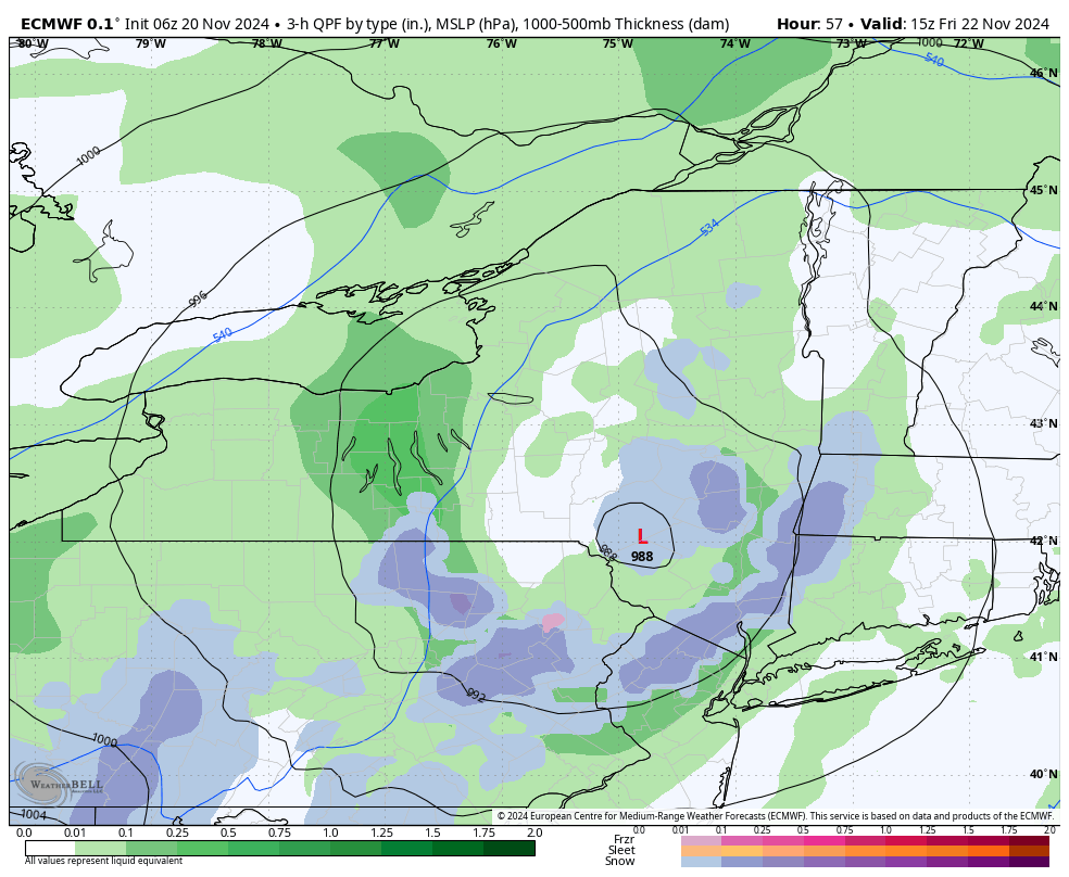
IF TRUE BL temps are marginal and it will stick with teh ehavier rates to cold surfaces and especially elevation areas
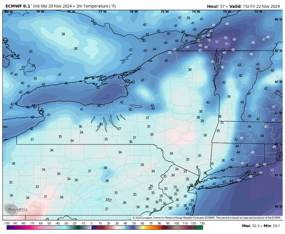
Dew Points at Freezing will help cool the boundary layer and allow stickage to ocld surfaces
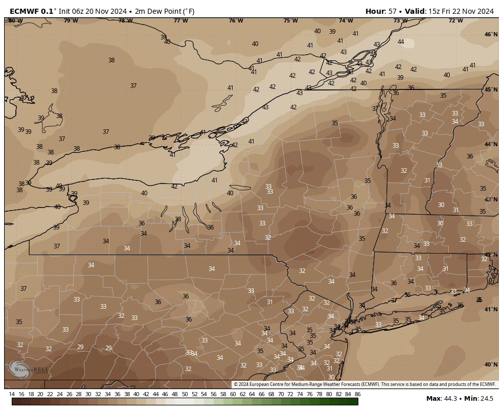
Positive Snow Depth - Isn't any and all snow POSITIVE??
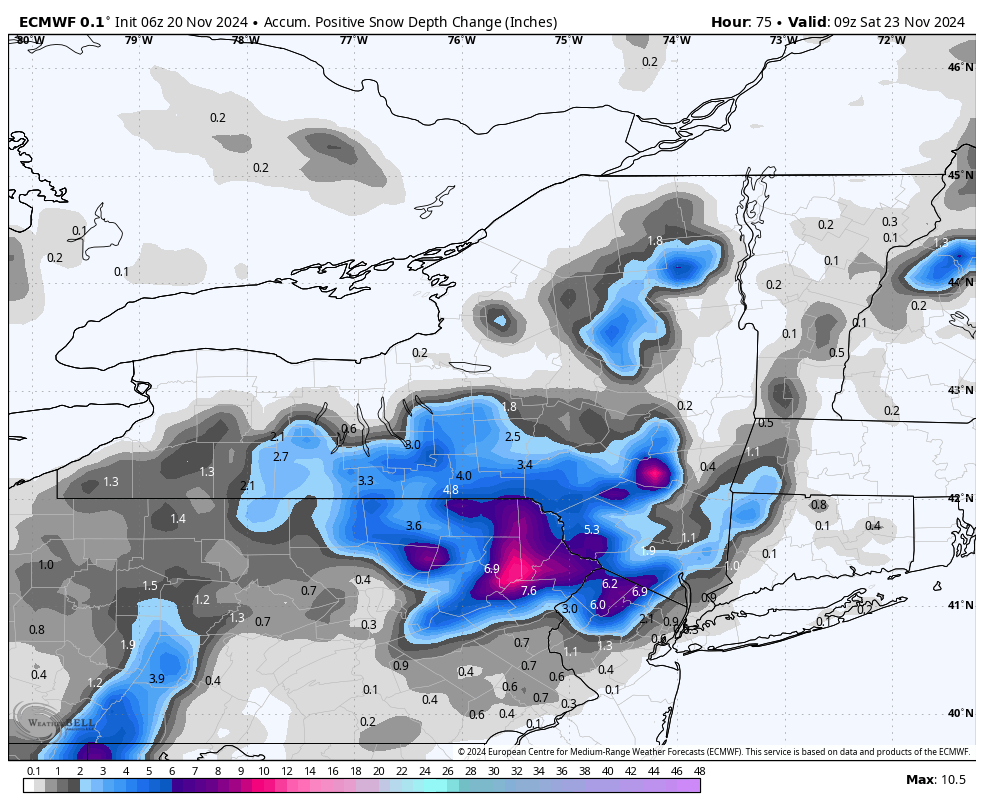
This is like a mid-late March storm - elevations are going to do well.
_________________
Mugs
AKA:King: Snow Weenie
Self Proclaimed
WINTER 2014-15 : 55.12" +.02 for 6 coatings (avg. 35")
WINTER 2015-16 Total - 29.8" (Avg 35")
WINTER 2016-17 : 39.5" so far

amugs- Advanced Forecaster - Mod

- Posts : 15143
Reputation : 213
Join date : 2013-01-07
Age : 54
Location : Hillsdale,NJ
kalleg and nancy-j-s like this post
 Re: First Snow of the Season?!
Early season #snow event likely for Northeast. Matches topography well since airmass is marginally cold for snow at the surface. As my professor always said..."2 ways to get to cold air, travel a few hundred miles north, or a few hundred feet up in elevation."
— Tom Niziol (@TomNiziol) November 19, 2024#winter pic.twitter.com/2EOCwnMzLU
_________________
Mugs
AKA:King: Snow Weenie
Self Proclaimed
WINTER 2014-15 : 55.12" +.02 for 6 coatings (avg. 35")
WINTER 2015-16 Total - 29.8" (Avg 35")
WINTER 2016-17 : 39.5" so far

amugs- Advanced Forecaster - Mod

- Posts : 15143
Reputation : 213
Join date : 2013-01-07
Age : 54
Location : Hillsdale,NJ
CPcantmeasuresnow, kalleg, nancy-j-s, heehaw453, weatherwatchermom, billg315 and frank 638 like this post
 Re: First Snow of the Season?!

_________________
Mugs
AKA:King: Snow Weenie
Self Proclaimed
WINTER 2014-15 : 55.12" +.02 for 6 coatings (avg. 35")
WINTER 2015-16 Total - 29.8" (Avg 35")
WINTER 2016-17 : 39.5" so far

amugs- Advanced Forecaster - Mod

- Posts : 15143
Reputation : 213
Join date : 2013-01-07
Age : 54
Location : Hillsdale,NJ
 Re: First Snow of the Season?!

_________________
Mugs
AKA:King: Snow Weenie
Self Proclaimed
WINTER 2014-15 : 55.12" +.02 for 6 coatings (avg. 35")
WINTER 2015-16 Total - 29.8" (Avg 35")
WINTER 2016-17 : 39.5" so far

amugs- Advanced Forecaster - Mod

- Posts : 15143
Reputation : 213
Join date : 2013-01-07
Age : 54
Location : Hillsdale,NJ
docstox12, CPcantmeasuresnow, kalleg and heehaw453 like this post
 Re: First Snow of the Season?!
To heehaw’s point about the maps, I think you really need to be observant and understand how different areas behave in certain situations. For example, this exact same situation occurred in November 2016 as I posted earlier. I was way out on a limb with that when I called for elevations to see 3-5”, and I still busted too low. As soon as the rain turned to snow, accumulations started almost immediately. How? Well, a couple reasons. First, the snow was falling at night, so even in a very marginal airmass, the lack of insolation aided with slight surface radiational cooling. Secondly, wet snow is much more efficient at removing heat from the surface than dry snow because of the much higher water content. Because of water’s very high specific heat, it takes a lot of energy to change its state, in this case from solid (snowflake) to liquid during the melting process when it hits the ground. This makes it highly efficient at cooling the surface just enough so that the rate of melting becomes less than the contact rate. The maps can approximate this, but it’s up to the meteorologist to adjust for these factors all over their forecast area. And I just don’t think a lot of people in the media take the time to look into such specifics and the whole picture. They’re on for 3-5 minutes, and that’s it.
I’m sticking with my idea that anybody outside the urban corridors and north of I-78 will see accumulations from this by Friday morning. Firstly, because I think this ends up further south than current guidance indicates. Secondly, I’ve learned to NEVER underestimate these strong upper-level lows, especially when they are so negatively tilted. Funny things seem to happen around them lol we shall see - 12z operationsals shifted ever so slightly north today. I don’t see it. As heehaw noted previously, the NAO blocking has continued to trend stronger and further south, and the anomaly maps show the effect on the trough. I think this is a signal that the operationals are too far north on today’s 12z’s.
rb924119- Meteorologist

- Posts : 7086
Reputation : 195
Join date : 2013-02-06
Age : 32
Location : Greentown, Pa
sroc4, CPcantmeasuresnow, kalleg, heehaw453, weatherwatchermom and billg315 like this post
 Re: First Snow of the Season?!
While we wait, take a look at the below image, which is an analysis of critical thicknesses (fancy name for various atmospheric thermal proxies for the rain/snow line throughout different sections of the vertical profile). Basically, they can help identify where there are any warm tongues aloft depending on where each line is in reference to the others. Now, if you recall from my video, I mentioned that I felt that this front would very steep throughout the column rather than more gently sloped, which would mean that once the front goes through, there would be a pretty rapid transition to snow behind it, and that the front and precipitation shield would arrive simultaneously. Well, if you look at the below image and note how the critical thicknesses are stacked on top of one another (except the 1000-850mb thickness, which is heavily skewed by the surface temps, and easily overcome for getting snow at the surface), this is pretty clear confirmation in-situ that my ideas were correct

rb924119- Meteorologist

- Posts : 7086
Reputation : 195
Join date : 2013-02-06
Age : 32
Location : Greentown, Pa
 Re: First Snow of the Season?!
Nice job as always NJ Strong crew. Special thanks to RB who was on this very early. I still don't think this will play out as white as he's thinking but his analysis as always is sound.

CPcantmeasuresnow- Wx Statistician Guru

- Posts : 7281
Reputation : 230
Join date : 2013-01-07
Age : 103
Location : Eastern Orange County, NY

 Home
Home


