
 Search
January 26-27 Possible System
Page 1 of 2 • 1, 2 ![]()

January 26-27 Possible System
![]() by Quietace Thu Jan 23, 2014 5:31 pm
by Quietace Thu Jan 23, 2014 5:31 pm
Continue discussion.
Doc, can you please post your earlier explanation here, its a great overview of the pattern.

Quietace- Meteorologist - Mod

- Posts : 3689
Reputation : 33
Join date : 2013-01-07
Age : 27
Location : Point Pleasant, NJ
Re: January 26-27 Possible System
![]() by Yschiff Thu Jan 23, 2014 5:58 pm
by Yschiff Thu Jan 23, 2014 5:58 pm
Yschiff- Posts : 139
Reputation : 1
Join date : 2014-01-04
Location : Far Rockaway New York
Re: January 26-27 Possible System
![]() by sroc4 Thu Jan 23, 2014 5:59 pm
by sroc4 Thu Jan 23, 2014 5:59 pm
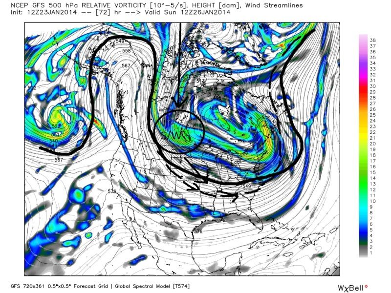
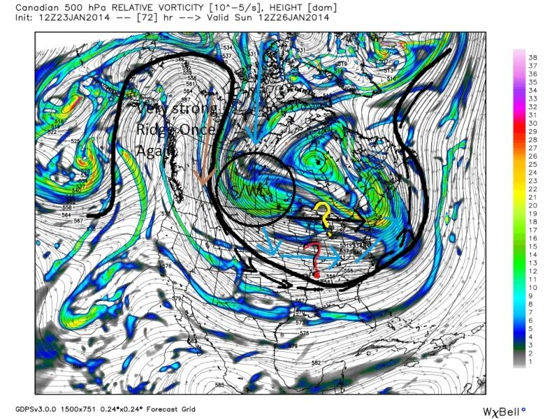
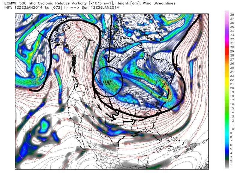
As was the case with this weeks storm the Ridge in the west is modeled to be very steep and extend N into Alaska. Here are the GFS, CMC, and Euro Models at 12z on Sunday. Notice how steep the ridge is and how North to south the orientation is of the western side of the trough. I have to believe as has been the case in the past that the s/w is not digging into the trough as much as is currently shown on the models, and that as we approach Friday nights 00z's and beyond the models will start trending more with that idea as it did in similar fashion with this weeks event. Ultimately why I think the models will not catch on to this again until only 36-60 hrs out is a lack of sampling of these energies.
 " />
" /> " />
" /> " />
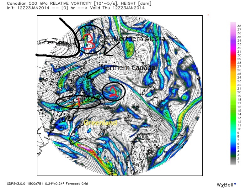
" />There are 3 pieces of energy that will interact and come together to create the short wave(s/w) that will dive into the northern plains and lead to this potential. Here is the Canadian Model at 12z today with the pieces of energy. Both the North American view and the Arctic view at 500mb to give a different perspective on where there energy is coming from. Notice how piece 1 is in Northern Canada, piece two is currently over the arctic, and piece 3 is just now coming in off the Pacific Ocean. All three geographic locations aren't exactly the most data rich locations.
 " />
" /> " />
" />With the ridge being as steep as it is being modeled there is now way for the models not to correct in the coming days. I believe models will correct showing the short wave digging into the trough more. So instead of the surface LP approaching the east coast with a track oriented west to east over the great lakes or Ohio valley we will see the surface LP track that originates further south and approaches the coast from SW to NE instead; leading toa moderate event. We shall see if my theory is correct over the next few days.
_________________
"In weather and in life, there's no winning and losing; there's only winning and learning."
WINTER 2012/2013 TOTALS 43.65"WINTER 2017/2018 TOTALS 62.85" WINTER 2022/2023 TOTALS 4.9"
WINTER 2013/2014 TOTALS 64.85"WINTER 2018/2019 TOTALS 14.25" WINTER 2023/2024 TOTALS 13.1"
WINTER 2014/2015 TOTALS 71.20"WINTER 2019/2020 TOTALS 6.35"
WINTER 2015/2016 TOTALS 35.00"WINTER 2020/2021 TOTALS 37.75"
WINTER 2016/2017 TOTALS 42.25"WINTER 2021/2022 TOTALS 31.65"

sroc4- Admin

- Posts : 8390
Reputation : 302
Join date : 2013-01-07
Location : Wading River, LI
Re: January 26-27 Possible System
![]() by jmanley32 Thu Jan 23, 2014 6:50 pm
by jmanley32 Thu Jan 23, 2014 6:50 pm

jmanley32- Senior Enthusiast

- Posts : 20593
Reputation : 108
Join date : 2013-12-12
Age : 43
Location : Yonkers, NY
Re: January 26-27 Possible System
![]() by Quietace Thu Jan 23, 2014 6:55 pm
by Quietace Thu Jan 23, 2014 6:55 pm
Bernie feels that with the PV moving NE, the vort will stay almost attached to the PV and swing around the base of the PV and not allow the SW to detach and dig southward. Though with the ridging being so N/S oriented, you would thing the velocity and energy of the shortwave would allow it to dig further south away from the PV and then use the PV to pivot and affect the area.jmanley32 wrote:Sroc I hope your right, cuz the accuweather explanation seemed just as convincing against a storm for us and he even said it would only be a few inches inland, but yes we are talking about accuwx, and their track record is not always so great.
Plus we have terrible sampling as Doc stated.
Quietace- Meteorologist - Mod
- Posts : 3689
Reputation : 33
Join date : 2013-01-07
Age : 27
Location : Point Pleasant, NJ
Re: January 26-27 Possible System
![]() by aiannone Thu Jan 23, 2014 6:59 pm
by aiannone Thu Jan 23, 2014 6:59 pm
Listen to the first 1:30 of the video and Bernie explains why he thinks the storm will miss us to the north.
_________________
-Alex Iannone-

aiannone- Senior Enthusiast - Mod

- Posts : 4817
Reputation : 92
Join date : 2013-01-07
Location : Saint James, LI (Northwest Suffolk Co.)
Re: January 26-27 Possible System
![]() by sroc4 Thu Jan 23, 2014 7:01 pm
by sroc4 Thu Jan 23, 2014 7:01 pm
Quietace wrote:Bernie feels that with the PV moving NE, the vort will stay almost attached to the PV and swing around the base of the PV and not allow the SW to detach and dig southward. Though with the ridging being so N/S oriented, you would thing the velocity and energy of the shortwave would allow it to dig further south away from the PV and then use the PV to pivot and affect the area.jmanley32 wrote:Sroc I hope your right, cuz the accuweather explanation seemed just as convincing against a storm for us and he even said it would only be a few inches inland, but yes we are talking about accuwx, and their track record is not always so great.
Plus we have terrible sampling as Doc stated.
Exactly my thoughts. Thats what I was trying to show on the 12z CMC on Sunday map with the two question marks, but I decided to present my argument slight different as I started to write it. We shall see. Remember I am not a metorologist. I am just telling it how I see it.
_________________
"In weather and in life, there's no winning and losing; there's only winning and learning."
WINTER 2012/2013 TOTALS 43.65"WINTER 2017/2018 TOTALS 62.85" WINTER 2022/2023 TOTALS 4.9"
WINTER 2013/2014 TOTALS 64.85"WINTER 2018/2019 TOTALS 14.25" WINTER 2023/2024 TOTALS 13.1"
WINTER 2014/2015 TOTALS 71.20"WINTER 2019/2020 TOTALS 6.35"
WINTER 2015/2016 TOTALS 35.00"WINTER 2020/2021 TOTALS 37.75"
WINTER 2016/2017 TOTALS 42.25"WINTER 2021/2022 TOTALS 31.65"
sroc4- Admin
- Posts : 8390
Reputation : 302
Join date : 2013-01-07
Location : Wading River, LI
Re: January 26-27 Possible System
![]() by Quietace Thu Jan 23, 2014 7:05 pm
by Quietace Thu Jan 23, 2014 7:05 pm
Quietace- Meteorologist - Mod
- Posts : 3689
Reputation : 33
Join date : 2013-01-07
Age : 27
Location : Point Pleasant, NJ
Re: January 26-27 Possible System
![]() by aiannone Thu Jan 23, 2014 7:07 pm
by aiannone Thu Jan 23, 2014 7:07 pm
_________________
-Alex Iannone-
aiannone- Senior Enthusiast - Mod
- Posts : 4817
Reputation : 92
Join date : 2013-01-07
Location : Saint James, LI (Northwest Suffolk Co.)
Re: January 26-27 Possible System
![]() by amugs Thu Jan 23, 2014 7:20 pm
by amugs Thu Jan 23, 2014 7:20 pm
Excellent analysis once again and this is my belief all along that models cannot catch onto this pattern and have not all frigin winter long -- Decembers pattern to much going on in the atmosphere and now it can't pick up on this as well. I see us having a moderate event as Frank said and you are showing and on the heels of this a possible major event Wed.
Love it Doc.
Mugs
_________________
Mugs
AKA:King: Snow Weenie
Self Proclaimed
WINTER 2014-15 : 55.12" +.02 for 6 coatings (avg. 35")
WINTER 2015-16 Total - 29.8" (Avg 35")
WINTER 2016-17 : 39.5" so far

amugs- Advanced Forecaster - Mod
- Posts : 15095
Reputation : 213
Join date : 2013-01-07
Age : 54
Location : Hillsdale,NJ
Re: January 26-27 Possible System
![]() by jmanley32 Thu Jan 23, 2014 7:55 pm
by jmanley32 Thu Jan 23, 2014 7:55 pm
jmanley32- Senior Enthusiast
- Posts : 20593
Reputation : 108
Join date : 2013-12-12
Age : 43
Location : Yonkers, NY
Re: January 26-27 Possible System
![]() by skinsfan1177 Thu Jan 23, 2014 7:58 pm
by skinsfan1177 Thu Jan 23, 2014 7:58 pm

skinsfan1177- Senior Enthusiast
- Posts : 4485
Reputation : 35
Join date : 2013-01-07
Age : 46
Location : Point Pleasant Boro
Re: January 26-27 Possible System
![]() by Quietace Thu Jan 23, 2014 8:11 pm
by Quietace Thu Jan 23, 2014 8:11 pm
Saturday is the light frontal/clipper event. Sunday-Monday storm(what this thread is about) and then another potential system in the Wednesday timeframe (29thish).skinsfan1177 wrote:Im confused here how many storms are we talking about saturday,sunday into monday then ome friday?
Quietace- Meteorologist - Mod
- Posts : 3689
Reputation : 33
Join date : 2013-01-07
Age : 27
Location : Point Pleasant, NJ
Re: January 26-27 Possible System
![]() by jmanley32 Thu Jan 23, 2014 8:20 pm
by jmanley32 Thu Jan 23, 2014 8:20 pm
jmanley32- Senior Enthusiast
- Posts : 20593
Reputation : 108
Join date : 2013-12-12
Age : 43
Location : Yonkers, NY
Re: January 26-27 Possible System
![]() by jmanley32 Thu Jan 23, 2014 8:21 pm
by jmanley32 Thu Jan 23, 2014 8:21 pm
jmanley32- Senior Enthusiast
- Posts : 20593
Reputation : 108
Join date : 2013-12-12
Age : 43
Location : Yonkers, NY
Re: January 26-27 Possible System
![]() by Quietace Thu Jan 23, 2014 8:22 pm
by Quietace Thu Jan 23, 2014 8:22 pm
This is the thread for the Sunday-Monday system. Wednesday-Thursday storm is on the long range thread for now.jmanley32 wrote:Sheesh well you all were right about it being active, it is a bit confusing maybe we should keep each topic seperate. Make a thread for Sun/Monday and a thread for Wednesday.
Quietace- Meteorologist - Mod
- Posts : 3689
Reputation : 33
Join date : 2013-01-07
Age : 27
Location : Point Pleasant, NJ
Re: January 26-27 Possible System
![]() by skinsfan1177 Thu Jan 23, 2014 8:36 pm
by skinsfan1177 Thu Jan 23, 2014 8:36 pm
skinsfan1177- Senior Enthusiast
- Posts : 4485
Reputation : 35
Join date : 2013-01-07
Age : 46
Location : Point Pleasant Boro
jmanley32- Senior Enthusiast
- Posts : 20593
Reputation : 108
Join date : 2013-12-12
Age : 43
Location : Yonkers, NY
Re: January 26-27 Possible System
![]() by Frank_Wx Thu Jan 23, 2014 10:35 pm
by Frank_Wx Thu Jan 23, 2014 10:35 pm
So as of now, I would say Monday is cloudy with some light snow showers possible - similar to Saturday of this week.
_________________
_______________________________________________________________________________________________________
CLICK HERE to view NJ Strong Snowstorm Classifications

Frank_Wx- Godzilla Seeker
- Posts : 21305
Reputation : 328
Join date : 2013-01-05
Age : 32
Location : Jersey City, NJ -

Re: January 26-27 Possible System
![]() by Yschiff Thu Jan 23, 2014 10:42 pm
by Yschiff Thu Jan 23, 2014 10:42 pm
Yschiff- Posts : 139
Reputation : 1
Join date : 2014-01-04
Location : Far Rockaway New York
Re: January 26-27 Possible System
![]() by CPcantmeasuresnow Thu Jan 23, 2014 11:10 pm
by CPcantmeasuresnow Thu Jan 23, 2014 11:10 pm

CPcantmeasuresnow- Wx Statistician Guru

- Posts : 7274
Reputation : 230
Join date : 2013-01-07
Age : 103
Location : Eastern Orange County, NY
Re: January 26-27 Possible System
![]() by sroc4 Fri Jan 24, 2014 5:58 am
by sroc4 Fri Jan 24, 2014 5:58 am
_________________
"In weather and in life, there's no winning and losing; there's only winning and learning."
WINTER 2012/2013 TOTALS 43.65"WINTER 2017/2018 TOTALS 62.85" WINTER 2022/2023 TOTALS 4.9"
WINTER 2013/2014 TOTALS 64.85"WINTER 2018/2019 TOTALS 14.25" WINTER 2023/2024 TOTALS 13.1"
WINTER 2014/2015 TOTALS 71.20"WINTER 2019/2020 TOTALS 6.35"
WINTER 2015/2016 TOTALS 35.00"WINTER 2020/2021 TOTALS 37.75"
WINTER 2016/2017 TOTALS 42.25"WINTER 2021/2022 TOTALS 31.65"
sroc4- Admin
- Posts : 8390
Reputation : 302
Join date : 2013-01-07
Location : Wading River, LI
Re: January 26-27 Possible System
![]() by HectorO Fri Jan 24, 2014 7:10 am
by HectorO Fri Jan 24, 2014 7:10 am

HectorO- Pro Enthusiast

- Posts : 966
Reputation : 27
Join date : 2013-01-11
Re: January 26-27 Possible System
![]() by Radz Fri Jan 24, 2014 8:35 am
by Radz Fri Jan 24, 2014 8:35 am
sroc4 wrote:I will give this idea until this evenings 00z's before its gone. As Frank stated above I will conceded for the most part GFS, CMC, Euro, and NAM are in fairly good agreement at 500mb with the idea that the PV drags this energy with it around its center as it pulls to the N and east instead of it breaking off allowing it digging into the trough over the mid west. As much as I hate to be wrong if this happens it actually would enforce my idea that I mentioned in an earlier post about how the models will come to a consensus quicker on some of these storm potentials as we are in an established pattern instead of going through a major pattern transition as we did late last week into earlier this week.
Well if this is correct, and the models are coming to a consensus quicker - sorta like a learning curve to the confusing pattern, then i'm a little bummed by the over night model run outcomes for the late week event as well. I know we saw a huge turn around with the last storm late in the game, but my hope for a Miller A threat is somewhat diminished today as well. Maybe we see a coating monday to freshen the snowpack again...

Radz- Pro Enthusiast
- Posts : 1028
Reputation : 17
Join date : 2013-01-12
Location : Cortlandt Manor NY
Re: January 26-27 Possible System
![]() by sroc4 Fri Jan 24, 2014 10:19 am
by sroc4 Fri Jan 24, 2014 10:19 am
Radz wrote:sroc4 wrote:I will give this idea until this evenings 00z's before its gone. As Frank stated above I will conceded for the most part GFS, CMC, Euro, and NAM are in fairly good agreement at 500mb with the idea that the PV drags this energy with it around its center as it pulls to the N and east instead of it breaking off allowing it digging into the trough over the mid west. As much as I hate to be wrong if this happens it actually would enforce my idea that I mentioned in an earlier post about how the models will come to a consensus quicker on some of these storm potentials as we are in an established pattern instead of going through a major pattern transition as we did late last week into earlier this week.
Well if this is correct, and the models are coming to a consensus quicker - sorta like a learning curve to the confusing pattern, then i'm a little bummed by the over night model run outcomes for the late week event as well. I know we saw a huge turn around with the last storm late in the game, but my hope for a Miller A threat is somewhat diminished today as well. Maybe we see a coating monday to freshen the snowpack again...
Agreed. This is what Steve Dimartino had to say about the later in the week threat.
Steve D for midweek threat.
This 500 MB pattern is not support for a winter storm.
The Polar Vortex is not in the correct position for one. Forcing the mean trough east.
Note the VERY strong disturbance over south-central Canada. That's a "kicker".
It does what it sounds like. Kick anything along the coast, east.
As such, the threat for Wednesday is VERY low unless the 500 MB pattern complete changes. Threat for snow showers though.
_________________
"In weather and in life, there's no winning and losing; there's only winning and learning."
WINTER 2012/2013 TOTALS 43.65"WINTER 2017/2018 TOTALS 62.85" WINTER 2022/2023 TOTALS 4.9"
WINTER 2013/2014 TOTALS 64.85"WINTER 2018/2019 TOTALS 14.25" WINTER 2023/2024 TOTALS 13.1"
WINTER 2014/2015 TOTALS 71.20"WINTER 2019/2020 TOTALS 6.35"
WINTER 2015/2016 TOTALS 35.00"WINTER 2020/2021 TOTALS 37.75"
WINTER 2016/2017 TOTALS 42.25"WINTER 2021/2022 TOTALS 31.65"
sroc4- Admin
- Posts : 8390
Reputation : 302
Join date : 2013-01-07
Location : Wading River, LI
Page 1 of 2 • 1, 2 ![]()
|
|
|