Long Range Thread 8.0
+30
Grselig
devsman
chief7
oldtimer
Noreaster
Quietace
mako460
jimv45
rb924119
sroc4
HectorO
snow247
essexcountypete
chinkaps
billg315
Snow88
dkodgis
docstox12
WOLVES1
nutleyblizzard
CPcantmeasuresnow
algae888
skinsfan1177
Dunnzoo
weatherwatchermom
Math23x7
jmanley32
amugs
Dtone
Frank_Wx
34 posters
Page 2 of 40
Page 2 of 40 •  1, 2, 3 ... 21 ... 40
 Re: Long Range Thread 8.0
There is an outside shot of CPK hitting 90 early next week. But if it doesn't, could this, in the 146+ years of weather records there, be the first year with NO 90 degree day? If you look back at 2004, there were only two 90 degree days, one on June 9th where it hit 91 and one on August 28th where it hit 90. May 1996 had two 90 degree days but there was only ONE that summer. In 2000 there were six 90 degree days in May and early June but only one the rest of the year. And in 2009 and 2014, the highest temperature was 92. So it'll be interesting to see how it turns out
Math23x7- Wx Statistician Guru

- Posts : 2382
Join date : 2013-01-08
 Re: Long Range Thread 8.0
Frank great write-up and math you are incredible with the statistics. Frank also the Sun has been very quiet and is supposed to be in a very quiet phase for foreseeable future even years to come. this has led to a warming of the stratosphere especially at 70mb which leads to cooler temperatures down at the surface. it will be interesting to see how the Sun affects our weather this winter. but there is a good chance that we will see more blocking in the Atlantic if the Sun remains quiet. what are your thoughts on this?

algae888- Advanced Forecaster

- Posts : 5311
Reputation : 46
Join date : 2013-02-05
Age : 62
Location : mt. vernon, new york
 Re: Long Range Thread 8.0
Math23x7 wrote:There is an outside shot of CPK hitting 90 early next week. But if it doesn't, could this, in the 146+ years of weather records there, be the first year with NO 90 degree day? If you look back at 2004, there were only two 90 degree days, one on June 9th where it hit 91 and one on August 28th where it hit 90. May 1996 had two 90 degree days but there was only ONE that summer. In 2000 there were six 90 degree days in May and early June but only one the rest of the year. And in 2009 and 2014, the highest temperature was 92. So it'll be interesting to see how it turns out
You know, its very possible we may not see a 90 degree day in CPK but it'll be hard to do. All it takes is one day of getting under a SW flow and we should hit it. The only way it doesn't happen is if the EPO stays negative the entire time and the trough in SE Canada doesn't budge. As long as there is a trough over the east, no 90s will come.
algae888 wrote:Frank great write-up and math you are incredible with the statistics. Frank also the Sun has been very quiet and is supposed to be in a very quiet phase for foreseeable future even years to come. this has led to a warming of the stratosphere especially at 70mb which leads to cooler temperatures down at the surface. it will be interesting to see how the Sun affects our weather this winter. but there is a good chance that we will see more blocking in the Atlantic if the Sun remains quiet. what are your thoughts on this?
I have to read more into the correlation between the sun and the NAO. You can see back in the epic winters of 2009-2011, the sun was inactive and the NAO was extremely negative with a +ENSO. We know upcoming winter will feature a +ENSO, but will the sun be inative? Will be interesting to follow.

_________________
_______________________________________________________________________________________________________
CLICK HERE to view NJ Strong Snowstorm Classifications
 Re: Long Range Thread 8.0
As part of my summer vacation educational initiative I am going to read two books, one called the sun earth ND moon and it's affects on our weather and the other climate change? Once I have read and digested the info I will have a fulls cake report to mi familia.
That se canadIan trough is a biatch that is keeping the 90 and heat south if the nyc area. Crazy but stone u pointed it out well.
That se canadIan trough is a biatch that is keeping the 90 and heat south if the nyc area. Crazy but stone u pointed it out well.
_________________
Mugs
AKA:King: Snow Weenie
Self Proclaimed
WINTER 2014-15 : 55.12" +.02 for 6 coatings (avg. 35")
WINTER 2015-16 Total - 29.8" (Avg 35")
WINTER 2016-17 : 39.5" so far

amugs- Advanced Forecaster - Mod

- Posts : 15148
Reputation : 213
Join date : 2013-01-07
Age : 54
Location : Hillsdale,NJ
 Re: Long Range Thread 8.0
Coastal storm this weekend?
That would suck mule balls.

That would suck mule balls.

_________________
_______________________________________________________________________________________________________
CLICK HERE to view NJ Strong Snowstorm Classifications
 Re: Long Range Thread 8.0
No wonder why models are hinting at a coastal storm this weekend - huge ridge spike in the west

And if the long range GFS is right, the +PNA turns into an extreme -EPO/+PNA pattern by July 4th. East remains cool.


And if the long range GFS is right, the +PNA turns into an extreme -EPO/+PNA pattern by July 4th. East remains cool.

_________________
_______________________________________________________________________________________________________
CLICK HERE to view NJ Strong Snowstorm Classifications
 Re: Long Range Thread 8.0
El Nino trying to become Un Hombre


_________________
_______________________________________________________________________________________________________
CLICK HERE to view NJ Strong Snowstorm Classifications
 Re: Long Range Thread 8.0
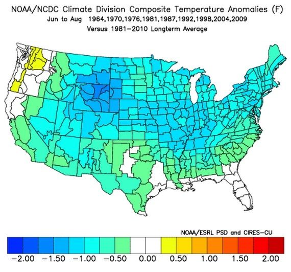
Frank, I mentioned this on another forum, but generally speaking (not always but generally), the start date for schools revolves around the date of Labor Day. And generally, the sooner it starts, the sooner it ends. And every five to six years, Labor Day on a later date than the previous year. This is the case this year since Labor Day is on September 7th while last year it was on the 1st. So this means these schools get an extra week of summer vacation. However, it doesnt help that for many years, these summers have been generally cool in the east, most recently in 2009. Here are the nine most recent years in which this was the case:

Now, because schools starts late in September of these years, it ends late the following June. Here are the five most recent of the nine years I posted and notice that they were all hot summers, most recently 2010.

Based on this data, I expect the summer of 2015 to be a cool summer but the summer of 2016 should be a HOT one.

Now, because schools starts late in September of these years, it ends late the following June. Here are the five most recent of the nine years I posted and notice that they were all hot summers, most recently 2010.

Based on this data, I expect the summer of 2015 to be a cool summer but the summer of 2016 should be a HOT one.
Math23x7- Wx Statistician Guru

- Posts : 2382
Reputation : 68
Join date : 2013-01-08
 Re: Long Range Thread 8.0
Wow, that is extremely interesting Mike. Fascinating to be honest. I wonder if those years have any other correlation with one another other than a delayed Labor Day?
_________________
_______________________________________________________________________________________________________
CLICK HERE to view NJ Strong Snowstorm Classifications
 Re: Long Range Thread 8.0
Coastal storm looks to be from inland this is non-tropical correct? Yes it would stink since its my b-day weekend : ( Normally a storm wouldn't bother me but I was hoping for a fun weekend. Whats Thursday and Friday look like as I am going on a road trip not far just to eastern CT.

jmanley32- Senior Enthusiast

- Posts : 20645
Reputation : 108
Join date : 2013-12-12
Age : 43
Location : Yonkers, NY
 Re: Long Range Thread 8.0
No thank you on the coastal this weekend, Grad party, Train concert at PNC Arts Center and Mets game on Sunday.... GO AWAY!
_________________
Janet
Snowfall winter of 2023-2024 17.5"
Snowfall winter of 2022-2023 6.0"
Snowfall winter of 2021-2022 17.6" 1" sleet 2/25/22
Snowfall winter of 2020-2021 51.1"
Snowfall winter of 2019-2020 8.5"
Snowfall winter of 2018-2019 25.1"
Snowfall winter of 2017-2018 51.9"
Snowfall winter of 2016-2017 45.6"
Snowfall winter of 2015-2016 29.5"
Snowfall winter of 2014-2015 50.55"
Snowfall winter of 2013-2014 66.5"

Dunnzoo- Senior Enthusiast - Mod

- Posts : 4934
Reputation : 68
Join date : 2013-01-11
Age : 62
Location : Westwood, NJ
 Re: Long Range Thread 8.0
jmanley32 wrote:Coastal storm looks to be from inland this is non-tropical correct? Yes it would stink since its my b-day weekend : ( Normally a storm wouldn't bother me but I was hoping for a fun weekend. Whats Thursday and Friday look like as I am going on a road trip not far just to eastern CT.
Thursday through Sunday looks fairly unsettled. The SE Ridge is pushing off the coast and a trough is moving in over the Great Lakes. We'll be stuck between the two, along the gradient, which is going to cause frequent storms to develop due to the unstable nature of the atmosphere. Obviously it will not rain every hour from Thurs-Sun, but in terms of overcast skies with periods of rain (heavy at times) that will hold true. Will update again tomorrow.
Dunnzoo wrote:No thank you on the coastal this weekend, Grad party, Train concert at PNC Arts Center and Mets game on Sunday.... GO AWAY!
Ponchos!
_________________
_______________________________________________________________________________________________________
CLICK HERE to view NJ Strong Snowstorm Classifications
 Re: Long Range Thread 8.0
Meh, not going to make plans for Rye Playland for Friday afternoon eve, if theres a chance of rain. I don't want to get caught in anything. 34 ain't no big deal anyways, I'll find some way to celebrate. So would you expect SPC to have us under tstorm parameters for those coming days too? Nothing in the 4-8 day yet.

jmanley32- Senior Enthusiast

- Posts : 20645
Reputation : 108
Join date : 2013-12-12
Age : 43
Location : Yonkers, NY
 Re: Long Range Thread 8.0
jmanley32 wrote:Meh, not going to make plans for Rye Playland for Friday afternoon eve, if theres a chance of rain. I don't want to get caught in anything. 34 ain't no big deal anyways, I'll find some way to celebrate. So would you expect SPC to have us under tstorm parameters for those coming days too? Nothing in the 4-8 day yet.
No, that's just a coastal storm with no severe weather expected. Temps may actually not get out of the 60's in some spots
_________________
_______________________________________________________________________________________________________
CLICK HERE to view NJ Strong Snowstorm Classifications
 Re: Long Range Thread 8.0
I like this look of our SST's for next winter 


_________________
_______________________________________________________________________________________________________
CLICK HERE to view NJ Strong Snowstorm Classifications
 Re: Long Range Thread 8.0
Frank_Wx wrote:jmanley32 wrote:Meh, not going to make plans for Rye Playland for Friday afternoon eve, if theres a chance of rain. I don't want to get caught in anything. 34 ain't no big deal anyways, I'll find some way to celebrate. So would you expect SPC to have us under tstorm parameters for those coming days too? Nothing in the 4-8 day yet.
No, that's just a coastal storm with no severe weather expected. Temps may actually not get out of the 60's in some spots
Never got out of the 60's here on Saturday. 68 was the high. I loved it.

CPcantmeasuresnow- Wx Statistician Guru

- Posts : 7283
Reputation : 230
Join date : 2013-01-07
Age : 103
Location : Eastern Orange County, NY
 Re: Long Range Thread 8.0
Frank_Wx wrote:I like this look of our SST's for next winter


Music to my ears.
Can't wait.

CPcantmeasuresnow- Wx Statistician Guru

- Posts : 7283
Reputation : 230
Join date : 2013-01-07
Age : 103
Location : Eastern Orange County, NY
 Re: Long Range Thread 8.0
I got to be honest I'm loving this weather at the Jersey shore

skinsfan1177- Senior Enthusiast

- Posts : 4485
Reputation : 35
Join date : 2013-01-07
Age : 47
Location : Point Pleasant Boro
 Re: Long Range Thread 8.0
Weekend Update:
Models backed off on the extreme rain amounts today and even pushed the timetable up a bit. We may be able to salvage a nice day Sunday. Friday to Saturday looks to be when the bulk of the rain falls. Right now I'm thinking a general 1-2 inches Friday into Saturday. There may be a break in the action Friday late morning through most of the day then start up again late Friday night and last through most of Saturday.
Models backed off on the extreme rain amounts today and even pushed the timetable up a bit. We may be able to salvage a nice day Sunday. Friday to Saturday looks to be when the bulk of the rain falls. Right now I'm thinking a general 1-2 inches Friday into Saturday. There may be a break in the action Friday late morning through most of the day then start up again late Friday night and last through most of Saturday.
_________________
_______________________________________________________________________________________________________
CLICK HERE to view NJ Strong Snowstorm Classifications
 Re: Long Range Thread 8.0
Worth noting that the GGEM still has rain all day Sunday so it's not set in stone yet. GFS is progressive with the coastal while the GGEM takes it inland up the coast and also slows it down.
_________________
_______________________________________________________________________________________________________
CLICK HERE to view NJ Strong Snowstorm Classifications
 Re: Long Range Thread 8.0
Thanks Frank...I knew you had connections 
_________________
Janet
Snowfall winter of 2023-2024 17.5"
Snowfall winter of 2022-2023 6.0"
Snowfall winter of 2021-2022 17.6" 1" sleet 2/25/22
Snowfall winter of 2020-2021 51.1"
Snowfall winter of 2019-2020 8.5"
Snowfall winter of 2018-2019 25.1"
Snowfall winter of 2017-2018 51.9"
Snowfall winter of 2016-2017 45.6"
Snowfall winter of 2015-2016 29.5"
Snowfall winter of 2014-2015 50.55"
Snowfall winter of 2013-2014 66.5"

Dunnzoo- Senior Enthusiast - Mod

- Posts : 4934
Reputation : 68
Join date : 2013-01-11
Age : 62
Location : Westwood, NJ
 Re: Long Range Thread 8.0
Dunnzoo wrote:Thanks Frank...I knew you had connections
Some people at work think I control the weather.
Please, I would have had Frankzilla's lining up in the winter if this were true.
_________________
_______________________________________________________________________________________________________
CLICK HERE to view NJ Strong Snowstorm Classifications
 Re: Long Range Thread 8.0
This is really bad news going to a outdoor wedding Saturday at 2pm in Barnegat nj

skinsfan1177- Senior Enthusiast

- Posts : 4485
Reputation : 35
Join date : 2013-01-07
Age : 47
Location : Point Pleasant Boro
 Re: Long Range Thread 8.0
skinsfan1177 wrote:This is really bad news going to a outdoor wedding Saturday at 2pm in Barnegat nj
Maybe if everyone can agree to bring a white umbrella, it will not look so bad.
_________________
_______________________________________________________________________________________________________
CLICK HERE to view NJ Strong Snowstorm Classifications
 Re: Long Range Thread 8.0
Frank_Wx wrote:skinsfan1177 wrote:This is really bad news going to a outdoor wedding Saturday at 2pm in Barnegat nj
Maybe if everyone can agree to bring a white umbrella, it will not look so bad.
Haha I'm going in a poncho. Seriously though is it looking like a all day event Frank it's in southern ocean county about 40 minutes to my south

skinsfan1177- Senior Enthusiast

- Posts : 4485
Reputation : 35
Join date : 2013-01-07
Age : 47
Location : Point Pleasant Boro
 Re: Long Range Thread 8.0
Can anyone give timing on Saturday rain and is it sat. Into Sunday or Friday into Saturday thank you

skinsfan1177- Senior Enthusiast

- Posts : 4485
Reputation : 35
Join date : 2013-01-07
Age : 47
Location : Point Pleasant Boro
Page 2 of 40 •  1, 2, 3 ... 21 ... 40
Page 2 of 40
Permissions in this forum:
You cannot reply to topics in this forum
 Home
Home