Long Range Thread 8.0
+30
Grselig
devsman
chief7
oldtimer
Noreaster
Quietace
mako460
jimv45
rb924119
sroc4
HectorO
snow247
essexcountypete
chinkaps
billg315
Snow88
dkodgis
docstox12
WOLVES1
nutleyblizzard
CPcantmeasuresnow
algae888
skinsfan1177
Dunnzoo
weatherwatchermom
Math23x7
jmanley32
amugs
Dtone
Frank_Wx
34 posters
Page 17 of 40
Page 17 of 40 •  1 ... 10 ... 16, 17, 18 ... 28 ... 40
 Re: Long Range Thread 8.0
nutleyblizzard wrote:https://twitter.com/philklotzbach/status/651069828740984832Things are looking great for us with the warm anomalies in the 3.4 region. Best forcing looks to be setting up by the dateline.
Nutley,
This is absolutely fantastic news - as I have and I know you have as well on here been harping since the summer or late summer how important for our dear winter it is for this area of the EPAC to be warm and it is a Vasin Wide event and it set up near the dateline - that is the trop forcing. If we can get region 4 to warm as much and I think it is then we will be in good shape for this upcoming winter. Hey, next year we are looking at La Nada/Nina so let's get it while and if we can. If it is a back loaded winter as we have seen in the past then fine no problem but if we can get a cold December like 2002-03 then we are in big business. QBO postive which is okay at this point tis from Isotherm :September 30mb QBO value has risen to +12.07, solidly westerly. Will be another factor to monitor for the ensuing winter. Very high likelihood that the QBO will average positive for DJFM.
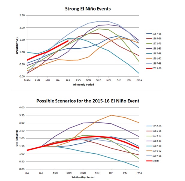
This is where we are at :

amugs- Advanced Forecaster - Mod

- Posts : 15149
Join date : 2013-01-07
 Re: Long Range Thread 8.0
1982-1983, a mod to strong El Nino year, the AMO was negative but the mean NAO for the ensuing winter was positive.

1972-1973, another Nino year, the AMO was also negative and the NAO was positive

Obviously these correlations are looked at as black and white, but the NAO/AMO correlation is difficult to understand during El Nino events

1972-1973, another Nino year, the AMO was also negative and the NAO was positive

Obviously these correlations are looked at as black and white, but the NAO/AMO correlation is difficult to understand during El Nino events
 Re: Long Range Thread 8.0
AMO is currently positive and has been for some time now with the exception of Jan through April 2014. As you pointed out the NAO was mostly positive Between Jan through April. Prior to that there was another transient neg AMO during the months of Nov/Dec/Jan 2011/2012. The last time the AMO was neg for more than just a few months you have to go back to the early to mid 1990's.
Here are the current and historical AMO values with Jan starting the column on the left
http://www.esrl.noaa.gov/psd/data/correlation/amon.us.data
NAO values:
http://www.esrl.noaa.gov/psd/data/correlation/nao.data
Referencing an article written by Joe Daleo here are the general associations with AMO and NAO values...again as a whole, not for transient time frames. Compared to the current Atlantic SST.

 " />
" />

As you can see the SST Anomalies match up with the 1965-1974 time frames. As per the image above we have a mostly negative NAO throughout that time frame. Within that time frame you have 1965-1966 and 1972-1973 both of which were strong El Ninos. You also have 1963-1964 as well which was a moderate el Nino year.
http://ggweather.com/enso/oni.htm
Refernece the NAO link again notice that during the three El Nino years I listed above a neg NAO predominate throught the winter season. 72-73 had a neg NAO in Jan positive in Feb and neutral to neg in March and april. The anomaly map Frank posted above does not match very well given the NAO therefore there were other factors at play. The AMO was in the pprocess of flipping at that time as well.
http://www.esrl.noaa.gov/psd/data/correlation/nao.data
There is no doubt that the equation is multifactorial; however, there are some general inferences that can be made with regards to AMO and NAO and a general relationship between the two depending on the phase of the AMO. Obviously my point in not to make a 1 to 1 relationship here and Of course other drivers play an integral part in the outcome of the overall equation as well. My point is that there is some validity to stating that the set up in the Atlantic at this stage "might" lead to a sustained NAO this winter.
Here are the current and historical AMO values with Jan starting the column on the left
http://www.esrl.noaa.gov/psd/data/correlation/amon.us.data
NAO values:
http://www.esrl.noaa.gov/psd/data/correlation/nao.data
Referencing an article written by Joe Daleo here are the general associations with AMO and NAO values...again as a whole, not for transient time frames. Compared to the current Atlantic SST.
 " />
" />
As you can see the SST Anomalies match up with the 1965-1974 time frames. As per the image above we have a mostly negative NAO throughout that time frame. Within that time frame you have 1965-1966 and 1972-1973 both of which were strong El Ninos. You also have 1963-1964 as well which was a moderate el Nino year.
http://ggweather.com/enso/oni.htm
Refernece the NAO link again notice that during the three El Nino years I listed above a neg NAO predominate throught the winter season. 72-73 had a neg NAO in Jan positive in Feb and neutral to neg in March and april. The anomaly map Frank posted above does not match very well given the NAO therefore there were other factors at play. The AMO was in the pprocess of flipping at that time as well.
http://www.esrl.noaa.gov/psd/data/correlation/nao.data
There is no doubt that the equation is multifactorial; however, there are some general inferences that can be made with regards to AMO and NAO and a general relationship between the two depending on the phase of the AMO. Obviously my point in not to make a 1 to 1 relationship here and Of course other drivers play an integral part in the outcome of the overall equation as well. My point is that there is some validity to stating that the set up in the Atlantic at this stage "might" lead to a sustained NAO this winter.
_________________
"In weather and in life, there's no winning and losing; there's only winning and learning."
WINTER 2012/2013 TOTALS 43.65"WINTER 2017/2018 TOTALS 62.85" WINTER 2022/2023 TOTALS 4.9"
WINTER 2013/2014 TOTALS 64.85"WINTER 2018/2019 TOTALS 14.25" WINTER 2023/2024 TOTALS 13.1"
WINTER 2014/2015 TOTALS 71.20"WINTER 2019/2020 TOTALS 6.35" WINTER 2024/2025 TOTALS 0.00
WINTER 2015/2016 TOTALS 35.00"WINTER 2020/2021 TOTALS 37.75"
WINTER 2016/2017 TOTALS 42.25"WINTER 2021/2022 TOTALS 31.65"

sroc4- Admin

- Posts : 8458
Reputation : 302
Join date : 2013-01-07
Location : Wading River, LI
 Re: Long Range Thread 8.0
Sustained neg NAO?

billg315- Advanced Forecaster - Mod

- Posts : 4562
Reputation : 185
Join date : 2015-01-24
Age : 50
Location : Flemington, NJ
 Re: Long Range Thread 8.0
February 1983 snowstorm.....to this day,I have not seen a snowstorm with 6 straight hours of 3 inch per hour accumulation rates.WITHOUT any letups!!!

docstox12- Wx Statistician Guru

- Posts : 8614
Reputation : 222
Join date : 2013-01-07
Age : 74
Location : Monroe NY
 Re: Long Range Thread 8.0
I'll be honest, the correlation is not strong enough for me to use it with conviction. Since the mid 90s we have been in a warm phase. As of today, the AMO remains in a warm phase. We've had memorable and impressive -NAO winters since the mid 90s. I probably need to take the time to research AMO more.


_________________
_______________________________________________________________________________________________________
CLICK HERE to view NJ Strong Snowstorm Classifications
 Re: Long Range Thread 8.0
GFS and ensembles keep showing a storm coming out of the gulf at the end of the run

Snow88- Senior Enthusiast

- Posts : 2193
Reputation : 4
Join date : 2013-01-09
Age : 36
Location : Brooklyn, NY
 Re: Long Range Thread 8.0
Was going to bring up storm in gulf but seemed so far away that I didn't. But that's where Sandy came from and same time frame so definitely interesting. Does the Euro show anything?

devsman- Pro Enthusiast

- Posts : 424
Reputation : 4
Join date : 2014-01-01
Age : 48
Location : merrick, ny (south shore of Long Island)
 Re: Long Range Thread 8.0
Hey guys I posted this in Banter being its 384 hrs out, Yes I noted same place as sandy and yesterday one run had a direct hit on the area with strong winds and crazy precip, but its 348 hrs out maybe a bit less but it sure has been consistent. Unfortunently the rest of the models only go out to 240 hrs (why is that?) so we won't know until its within 240 hrs if they match, I did not something percolating at 240 hrs on Euro in the Yucatan area so that may be it.

jmanley32- Senior Enthusiast

- Posts : 20645
Reputation : 108
Join date : 2013-12-12
Age : 43
Location : Yonkers, NY
 Re: Long Range Thread 8.0
devsman wrote:Was going to bring up storm in gulf but seemed so far away that I didn't. But that's where Sandy came from and same time frame so definitely interesting. Does the Euro show anything?
Also to note climatology favors east coast runs with storms that come from there in October so may be something to watch down the road.

jmanley32- Senior Enthusiast

- Posts : 20645
Reputation : 108
Join date : 2013-12-12
Age : 43
Location : Yonkers, NY
 Re: Long Range Thread 8.0
CA SST analog forecast DJF blownup USA:

This is somewhat unnerving at this point - east coast is spiking here peeps, un-comfortable . Do not know if it actually has a grip on the dateline warming in regions 4 and 3.4.
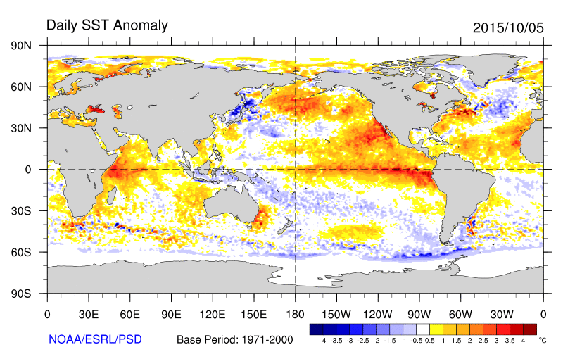

This is somewhat unnerving at this point - east coast is spiking here peeps, un-comfortable . Do not know if it actually has a grip on the dateline warming in regions 4 and 3.4.

_________________
Mugs
AKA:King: Snow Weenie
Self Proclaimed
WINTER 2014-15 : 55.12" +.02 for 6 coatings (avg. 35")
WINTER 2015-16 Total - 29.8" (Avg 35")
WINTER 2016-17 : 39.5" so far

amugs- Advanced Forecaster - Mod

- Posts : 15149
Reputation : 213
Join date : 2013-01-07
Age : 54
Location : Hillsdale,NJ
 Re: Long Range Thread 8.0
In what respect, mugs?
rb924119- Meteorologist

- Posts : 7109
Reputation : 195
Join date : 2013-02-06
Age : 32
Location : Greentown, Pa
 Re: Long Range Thread 8.0
rb924119 wrote:In what respect, mugs?
that the warm waters where basin wide but congregated around the 1.2 region as the warmest waters - if I am reading this correctly, my first time through this with nino so i am a Nino virgin hahahaha!!
Anyway, I can relax after reading this tweet - maybe I got ahead of myself with this above.
https://twitter.com/mjventrice/status/651422220980494336
Take the train to the dateline yahooooooooooooo!!

All is good and the ship is righted - the map just caught me off guard I guess. Again my first time posting for nino's so I have some to learn.
_________________
Mugs
AKA:King: Snow Weenie
Self Proclaimed
WINTER 2014-15 : 55.12" +.02 for 6 coatings (avg. 35")
WINTER 2015-16 Total - 29.8" (Avg 35")
WINTER 2016-17 : 39.5" so far

amugs- Advanced Forecaster - Mod

- Posts : 15149
Reputation : 213
Join date : 2013-01-07
Age : 54
Location : Hillsdale,NJ
 Re: Long Range Thread 8.0
I'm not sure what this basin wide Nino stuff is I know it's better for us for winter can so.done give an easy explanation?

skinsfan1177- Senior Enthusiast

- Posts : 4485
Reputation : 35
Join date : 2013-01-07
Age : 47
Location : Point Pleasant Boro
 Re: Long Range Thread 8.0
amugs wrote:rb924119 wrote:In what respect, mugs?
that the warm waters where basin wide but congregated around the 1.2 region as the warmest waters - if I am reading this correctly, my first time through this with nino so i am a Nino virgin hahahaha!!
Anyway, I can relax after reading this tweet - maybe I got ahead of myself with this above.
https://twitter.com/mjventrice/status/651422220980494336
Take the train to the dateline yahooooooooooooo!!
All is good and the ship is righted - the map just caught me off guard I guess. Again my first time posting for nino's so I have some to learn.
Oh haha I see. Don't forget, that map was of ANOMALIES, so yeah, it's totally reasonable that the darker colors are in region 1.2. Waters that are normally in the 40's and 50's are now in the 60's. The warmest waters are still well off to the west, but are slowly being advected eastward, which is why you're continuing to see the colors darken in 1.2; the anomalies are getting larger as the waters from the central and western Pacific are warming those off the South American coastline as they mix together. You'll know when the Nino is starting to wind down when the water temperatures are nearly uniform basin-wide, and actually start to "cool off" toward the western Pacific. Just like with the atmosphere, where water leaves it must be replaced, so it will start to upwell in the source region (western/west-central Pacific).
rb924119- Meteorologist

- Posts : 7109
Reputation : 195
Join date : 2013-02-06
Age : 32
Location : Greentown, Pa
 Re: Long Range Thread 8.0
And that plot from the tweet is staggering. Like...D@MN. lol
rb924119- Meteorologist

- Posts : 7109
Reputation : 195
Join date : 2013-02-06
Age : 32
Location : Greentown, Pa
 Re: Long Range Thread 8.0
MY GOD:


rb924119- Meteorologist

- Posts : 7109
Reputation : 195
Join date : 2013-02-06
Age : 32
Location : Greentown, Pa
 Re: Long Range Thread 8.0
That map is a beautiful sight. This is how I envision our wunter, Aleutian liw, nice pna from the west into bc and Canada and trough east with a negative NAO block
_________________
Mugs
AKA:King: Snow Weenie
Self Proclaimed
WINTER 2014-15 : 55.12" +.02 for 6 coatings (avg. 35")
WINTER 2015-16 Total - 29.8" (Avg 35")
WINTER 2016-17 : 39.5" so far

amugs- Advanced Forecaster - Mod

- Posts : 15149
Reputation : 213
Join date : 2013-01-07
Age : 54
Location : Hillsdale,NJ
 Re: Long Range Thread 8.0
What are we looking at for the big change and temp wise of course if it verifys.

skinsfan1177- Senior Enthusiast

- Posts : 4485
Reputation : 35
Join date : 2013-01-07
Age : 47
Location : Point Pleasant Boro
 Re: Long Range Thread 8.0
From Isotherm:
Fairly robust burst of positive 850-Hpa U anomalies in the 180-140W region, indicative of the westerly wind burst. This will probably induce a further warming of regions 3.4/3 and even region 4 in the coming week. Recent CFSV2 runs continue to suggest that region 1.2 will be gradually declining over the next several weeks to levels eventually sub +2.0c. My guess is this may occur by early November.
Laymen terms - region 3.4 and 4 are warming up which is evident at eh Dateline (the international dateline which is at 180W on our space ship we call earth - think about that one!). East regions from this will be cooling. This is very good news for the upcoming winter.
Here i sthe bathtub of or should I say HOT TUB!!!!
A large area of convection is focusing right over those 30C SST's in the Nino 4 region !!!

_________________
Mugs
AKA:King: Snow Weenie
Self Proclaimed
WINTER 2014-15 : 55.12" +.02 for 6 coatings (avg. 35")
WINTER 2015-16 Total - 29.8" (Avg 35")
WINTER 2016-17 : 39.5" so far

amugs- Advanced Forecaster - Mod

- Posts : 15149
Reputation : 213
Join date : 2013-01-07
Age : 54
Location : Hillsdale,NJ
 Re: Long Range Thread 8.0
That's very good to see. As long as the best forcing stays that far west, that in turn should keep the GOA low south of the Aleutians and then we'll be in great shape.amugs wrote:From Isotherm:
Fairly robust burst of positive 850-Hpa U anomalies in the 180-140W region, indicative of the westerly wind burst. This will probably induce a further warming of regions 3.4/3 and even region 4 in the coming week. Recent CFSV2 runs continue to suggest that region 1.2 will be gradually declining over the next several weeks to levels eventually sub +2.0c. My guess is this may occur by early November.
Laymen terms - region 3.4 and 4 are warming up which is evident at eh Dateline (the international dateline which is at 180W on our space ship we call earth - think about that one!). East regions from this will be cooling. This is very good news for the upcoming winter.
Here i sthe bathtub of or should I say HOT TUB!!!!
A large area of convection is focusing right over those 30C SST's in the Nino 4 region !!!


nutleyblizzard- Senior Enthusiast

- Posts : 1963
Reputation : 41
Join date : 2014-01-30
Age : 58
Location : Nutley, new jersey
 Re: Long Range Thread 8.0
mugs the pna spike is going to be enhanced by hurricane oho which is east of Hawaii and headed towards Alaska. this will push record breaking heat into the n/w and upper mid west next week. will this hurricane have an impact on sst in the pacific off the west coast?

algae888- Advanced Forecaster

- Posts : 5311
Reputation : 46
Join date : 2013-02-05
Age : 62
Location : mt. vernon, new york
 Re: Long Range Thread 8.0
algae888 wrote:mugs the pna spike is going to be enhanced by hurricane oho which is east of Hawaii and headed towards Alaska. this will push record breaking heat into the n/w and upper mid west next week. will this hurricane have an impact on sst in the pacific off the west coast?
It could give an upwelling affect to that area butt hat may be a small area or a spec in the overall picture. There is WWB (Westerly Wind Burst) being recorded off the South American west coast that is showing a westward movement of the warmer waters from region 1.2 out towards 3 and 3.4. if this is the case then I believe this hurricane does not have much impact on the sst but for small period of time.
A WWB will help move the warm waters at he initial surface layers out along with its direction - westward. Think of it as the East and NE winds we experienced this weekend on our coast for an analogy.
_________________
Mugs
AKA:King: Snow Weenie
Self Proclaimed
WINTER 2014-15 : 55.12" +.02 for 6 coatings (avg. 35")
WINTER 2015-16 Total - 29.8" (Avg 35")
WINTER 2016-17 : 39.5" so far

amugs- Advanced Forecaster - Mod

- Posts : 15149
Reputation : 213
Join date : 2013-01-07
Age : 54
Location : Hillsdale,NJ
 Re: Long Range Thread 8.0
Swiped this from one JB's boys :
Look at the westward hot tub, forcing setting up near the dateline, going as planned if not better - Am I making a meteorological point here or being an annoying Joe and kicking the dog with this?


Look at the westward hot tub, forcing setting up near the dateline, going as planned if not better - Am I making a meteorological point here or being an annoying Joe and kicking the dog with this?


_________________
Mugs
AKA:King: Snow Weenie
Self Proclaimed
WINTER 2014-15 : 55.12" +.02 for 6 coatings (avg. 35")
WINTER 2015-16 Total - 29.8" (Avg 35")
WINTER 2016-17 : 39.5" so far

amugs- Advanced Forecaster - Mod

- Posts : 15149
Reputation : 213
Join date : 2013-01-07
Age : 54
Location : Hillsdale,NJ
 Re: Long Range Thread 8.0
Mugs, when it comes sharing potential good winter weather you are not kicking a dead dog. You are giving a living dog a nice refreshing bowl of water and some tasty bacon.
Grselig- Senior Enthusiast

- Posts : 1410
Reputation : 140
Join date : 2013-03-04
Age : 54
Location : Wayne NJ
 Re: Long Range Thread 8.0
All hail? 


rb924119- Meteorologist

- Posts : 7109
Reputation : 195
Join date : 2013-02-06
Age : 32
Location : Greentown, Pa
 Re: Long Range Thread 8.0
Rb^^^^^ that is impressive - again give me this come Jan and Feb and I will........................ 


Anyway, now that it looks like we have the pattern what will happen to that ULL the GFS and EURO are showing coming out of the tropics region? Hope we can capture that in this pattern.


Anyway, now that it looks like we have the pattern what will happen to that ULL the GFS and EURO are showing coming out of the tropics region? Hope we can capture that in this pattern.
_________________
Mugs
AKA:King: Snow Weenie
Self Proclaimed
WINTER 2014-15 : 55.12" +.02 for 6 coatings (avg. 35")
WINTER 2015-16 Total - 29.8" (Avg 35")
WINTER 2016-17 : 39.5" so far

amugs- Advanced Forecaster - Mod

- Posts : 15149
Reputation : 213
Join date : 2013-01-07
Age : 54
Location : Hillsdale,NJ
Page 17 of 40 •  1 ... 10 ... 16, 17, 18 ... 28 ... 40
Page 17 of 40
Permissions in this forum:
You cannot reply to topics in this forum
 Home
Home