Long Range Thread 8.0
+30
Grselig
devsman
chief7
oldtimer
Noreaster
Quietace
mako460
jimv45
rb924119
sroc4
HectorO
snow247
essexcountypete
chinkaps
billg315
Snow88
dkodgis
docstox12
WOLVES1
nutleyblizzard
CPcantmeasuresnow
algae888
skinsfan1177
Dunnzoo
weatherwatchermom
Math23x7
jmanley32
amugs
Dtone
Frank_Wx
34 posters
Page 33 of 40
Page 33 of 40 •  1 ... 18 ... 32, 33, 34 ... 36 ... 40
 Re: Long Range Thread 8.0
OT but the time is now 2 hours off and now quite frusturating to read especially at night, anyway to get this fixed? I thought during DST last year it got fixed not more off. Maybe im mistaking but oddly its bothering me now more than it did if it was the same.
NjWeatherGuy- Advanced Forecaster

- Posts : 4100
Join date : 2013-01-06
 Re: Long Range Thread 8.0
Try going to Profile - Preferences - Time Zone.NjWeatherGuy wrote:OT but the time is now 2 hours off and now quite frusturating to read especially at night, anyway to get this fixed? I thought during DST last year it got fixed not more off. Maybe im mistaking but oddly its bothering me now more than it did if it was the same.
Math23x7- Wx Statistician Guru

- Posts : 2382
Join date : 2013-01-08
 Re: Long Range Thread 8.0
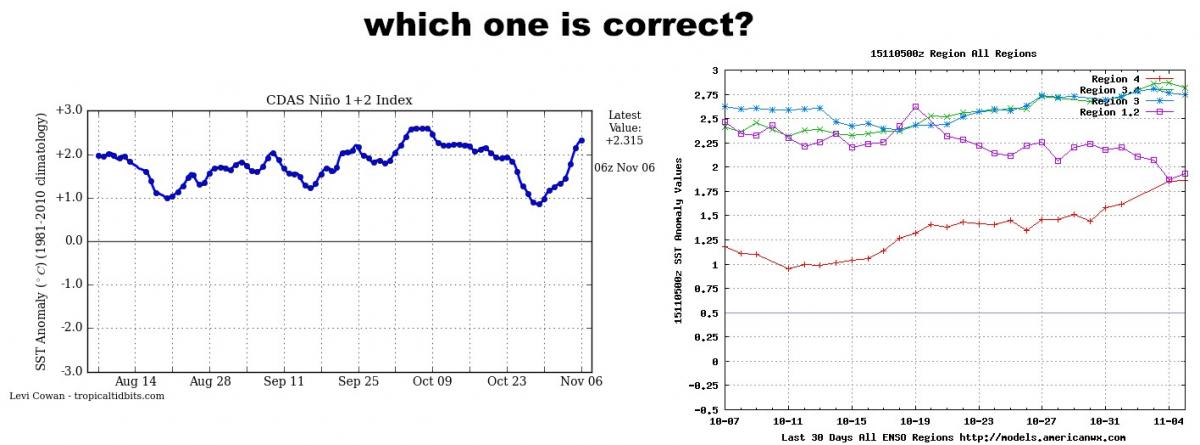
Which graph is correct here? one showing 1.2 warming and one showing it cooling. the Aussies have 1.2 peaking in early Oct. There is a wwb again but it doesn't look like it will make a big impact on this region.

_________________
Mugs
AKA:King: Snow Weenie
Self Proclaimed
WINTER 2014-15 : 55.12" +.02 for 6 coatings (avg. 35")
WINTER 2015-16 Total - 29.8" (Avg 35")
WINTER 2016-17 : 39.5" so far

amugs- Advanced Forecaster - Mod

- Posts : 15149
Reputation : 213
Join date : 2013-01-07
Age : 54
Location : Hillsdale,NJ
 Re: Long Range Thread 8.0
amugs wrote:Which graph is correct here? one showing 1.2 warming and one showing it cooling. the Aussies have 1.2 peaking in early Oct. There is a wwb again but it doesn't look like it will make a big impact on this region.
This image of the last week temp anomaly change, which Frank also posted yesterday, would lead me to believe the former. Def warming going on off the S Amer coast over the past week or two. And actually if you look closely at the Aussie graph it too is showing warming in between the last two plots on the graph.

_________________
"In weather and in life, there's no winning and losing; there's only winning and learning."
WINTER 2012/2013 TOTALS 43.65"WINTER 2017/2018 TOTALS 62.85" WINTER 2022/2023 TOTALS 4.9"
WINTER 2013/2014 TOTALS 64.85"WINTER 2018/2019 TOTALS 14.25" WINTER 2023/2024 TOTALS 13.1"
WINTER 2014/2015 TOTALS 71.20"WINTER 2019/2020 TOTALS 6.35" WINTER 2024/2025 TOTALS 0.00
WINTER 2015/2016 TOTALS 35.00"WINTER 2020/2021 TOTALS 37.75"
WINTER 2016/2017 TOTALS 42.25"WINTER 2021/2022 TOTALS 31.65"

sroc4- Admin

- Posts : 8458
Reputation : 302
Join date : 2013-01-07
Location : Wading River, LI
 Re: Long Range Thread 8.0
amugs wrote:Which graph is correct here? one showing 1.2 warming and one showing it cooling. the Aussies have 1.2 peaking in early Oct. There is a wwb again but it doesn't look like it will make a big impact on this region.
Seems to me like that area is warming. (not a good thing for us) Could it be that the upwelling caused by the major cat 5 hurricane has subsided and that was responsible for the cooling the past few weeks.
Guest- Guest
 Re: Long Range Thread 8.0
Keep in mind Nino region 1.2 is the shallowest region. And due to this temps can change much more rapidly one way or the other. No one should be worried about this at this time. Its simply something to monitor over time. If the same trends cont into Jan I will be worried.
_________________
"In weather and in life, there's no winning and losing; there's only winning and learning."
WINTER 2012/2013 TOTALS 43.65"WINTER 2017/2018 TOTALS 62.85" WINTER 2022/2023 TOTALS 4.9"
WINTER 2013/2014 TOTALS 64.85"WINTER 2018/2019 TOTALS 14.25" WINTER 2023/2024 TOTALS 13.1"
WINTER 2014/2015 TOTALS 71.20"WINTER 2019/2020 TOTALS 6.35" WINTER 2024/2025 TOTALS 0.00
WINTER 2015/2016 TOTALS 35.00"WINTER 2020/2021 TOTALS 37.75"
WINTER 2016/2017 TOTALS 42.25"WINTER 2021/2022 TOTALS 31.65"

sroc4- Admin

- Posts : 8458
Reputation : 302
Join date : 2013-01-07
Location : Wading River, LI
 Re: Long Range Thread 8.0
I can't post map I'm on my phone but the long range gfs looks very cold looks like around day 12 we could have some blocking. the NAO looks to be going negative hopefully the fun will begin soon

algae888- Advanced Forecaster

- Posts : 5311
Reputation : 46
Join date : 2013-02-05
Age : 62
Location : mt. vernon, new york
 Re: Long Range Thread 8.0
algae888 wrote:I can't post map I'm on my phone but the long range gfs looks very cold looks like around day 12 we could have some blocking. the NAO looks to be going negative hopefully the fun will begin soon
GOD DARN YOU AL!!! You spoiled it!!! lmfao But, to aid:


You guys can't see it, but I'm crying out of joy right now aha
rb924119- Meteorologist

- Posts : 7109
Reputation : 195
Join date : 2013-02-06
Age : 32
Location : Greentown, Pa
 Re: Long Range Thread 8.0
This is as impressive as that look we had for the brief outbreak in October. In fact, almost identical in looks and timing with regard to when the models picked it up. Hmmmmmm
rb924119- Meteorologist

- Posts : 7109
Reputation : 195
Join date : 2013-02-06
Age : 32
Location : Greentown, Pa
 Re: Long Range Thread 8.0
Interesting to note as well, is the ensemble mean height anomalies:

Depicting pattern amplification, but out of phase with the Operational. Again, with respect to my earlier hypothesis, it will be interesting to see how this trends if the signal for pattern amplification persist.

Depicting pattern amplification, but out of phase with the Operational. Again, with respect to my earlier hypothesis, it will be interesting to see how this trends if the signal for pattern amplification persist.
rb924119- Meteorologist

- Posts : 7109
Reputation : 195
Join date : 2013-02-06
Age : 32
Location : Greentown, Pa
 Re: Long Range Thread 8.0
Side-by-side comparison of the GFS Op to the Euro Op:
Euro:

GFS:

VERY similar at hour 240. Interesting.
Euro:

GFS:

VERY similar at hour 240. Interesting.
rb924119- Meteorologist

- Posts : 7109
Reputation : 195
Join date : 2013-02-06
Age : 32
Location : Greentown, Pa
 Re: Long Range Thread 8.0
Lets not jump the gun here guys. Its the LR GFS!! Here is the current run:


Sexy Gorgeous Beautiful. Sub Aleutian trough pumping the alaskan ridge, plus greenland blocking equals beautiful east coast trough. But like some woman (and Men). This may end up being good from far, but far from good when we get closer.
The GFS's own ensembles currently do not agree. Trough in the west; sub Aleutian Ridging.


Dont get me wrong I am in the camp that the pattern is going to begin changing from what we see now to more seasonal temps if not a few cool shots as well for the the second half or third of the month but this run should not be taken seriously right now.


Sexy Gorgeous Beautiful. Sub Aleutian trough pumping the alaskan ridge, plus greenland blocking equals beautiful east coast trough. But like some woman (and Men). This may end up being good from far, but far from good when we get closer.
The GFS's own ensembles currently do not agree. Trough in the west; sub Aleutian Ridging.


Dont get me wrong I am in the camp that the pattern is going to begin changing from what we see now to more seasonal temps if not a few cool shots as well for the the second half or third of the month but this run should not be taken seriously right now.
_________________
"In weather and in life, there's no winning and losing; there's only winning and learning."
WINTER 2012/2013 TOTALS 43.65"WINTER 2017/2018 TOTALS 62.85" WINTER 2022/2023 TOTALS 4.9"
WINTER 2013/2014 TOTALS 64.85"WINTER 2018/2019 TOTALS 14.25" WINTER 2023/2024 TOTALS 13.1"
WINTER 2014/2015 TOTALS 71.20"WINTER 2019/2020 TOTALS 6.35" WINTER 2024/2025 TOTALS 0.00
WINTER 2015/2016 TOTALS 35.00"WINTER 2020/2021 TOTALS 37.75"
WINTER 2016/2017 TOTALS 42.25"WINTER 2021/2022 TOTALS 31.65"

sroc4- Admin

- Posts : 8458
Reputation : 302
Join date : 2013-01-07
Location : Wading River, LI
 Re: Long Range Thread 8.0
Sroc,
Same page, buddy haha
rb924119 wrote:Interesting to note as well, is the ensemble mean height anomalies:
Depicting pattern amplification, but out of phase with the Operational. Again, with respect to my earlier hypothesis, it will be interesting to see how this trends if the signal for pattern amplification persist.
Same page, buddy haha
rb924119- Meteorologist

- Posts : 7109
Reputation : 195
Join date : 2013-02-06
Age : 32
Location : Greentown, Pa
 Re: Long Range Thread 8.0
If I follow correctly, we are on a waver between a crap winter and a average winter am I correct? Nothing exceptionally exciting chances?

jmanley32- Senior Enthusiast

- Posts : 20646
Reputation : 108
Join date : 2013-12-12
Age : 43
Location : Yonkers, NY
 Re: Long Range Thread 8.0
rb924119 wrote:Sroc,rb924119 wrote:Interesting to note as well, is the ensemble mean height anomalies:
Depicting pattern amplification, but out of phase with the Operational. Again, with respect to my earlier hypothesis, it will be interesting to see how this trends if the signal for pattern amplification persist.
Same page, buddy haha
Ha ya beat me to it.
_________________
"In weather and in life, there's no winning and losing; there's only winning and learning."
WINTER 2012/2013 TOTALS 43.65"WINTER 2017/2018 TOTALS 62.85" WINTER 2022/2023 TOTALS 4.9"
WINTER 2013/2014 TOTALS 64.85"WINTER 2018/2019 TOTALS 14.25" WINTER 2023/2024 TOTALS 13.1"
WINTER 2014/2015 TOTALS 71.20"WINTER 2019/2020 TOTALS 6.35" WINTER 2024/2025 TOTALS 0.00
WINTER 2015/2016 TOTALS 35.00"WINTER 2020/2021 TOTALS 37.75"
WINTER 2016/2017 TOTALS 42.25"WINTER 2021/2022 TOTALS 31.65"

sroc4- Admin

- Posts : 8458
Reputation : 302
Join date : 2013-01-07
Location : Wading River, LI
 Re: Long Range Thread 8.0
jmanley32 wrote:If I follow correctly, we are on a waver between a crap winter and a average winter am I correct? Nothing exceptionally exciting chances?
Jman I believe this will have no bearing on the main part of the winter which in agreement to Franks winter oulook will begin full throttle later Jan. However, I do think that we see the pattern waffle starting with the second half of this month, with true snow chances(at least a few of us) esp in the first 2/3 of Dec. before the pattern relaxes again and reloads before locking back in again, for later Jan. and the meat of the winter. Thats just me though
_________________
"In weather and in life, there's no winning and losing; there's only winning and learning."
WINTER 2012/2013 TOTALS 43.65"WINTER 2017/2018 TOTALS 62.85" WINTER 2022/2023 TOTALS 4.9"
WINTER 2013/2014 TOTALS 64.85"WINTER 2018/2019 TOTALS 14.25" WINTER 2023/2024 TOTALS 13.1"
WINTER 2014/2015 TOTALS 71.20"WINTER 2019/2020 TOTALS 6.35" WINTER 2024/2025 TOTALS 0.00
WINTER 2015/2016 TOTALS 35.00"WINTER 2020/2021 TOTALS 37.75"
WINTER 2016/2017 TOTALS 42.25"WINTER 2021/2022 TOTALS 31.65"

sroc4- Admin

- Posts : 8458
Reputation : 302
Join date : 2013-01-07
Location : Wading River, LI
 Re: Long Range Thread 8.0
Well I look at all your ideas and try to come to a middle Idea, seems like you are all close on ideas, but kinda a waiting game now, we know how these LR models can be. BTW everyone check the off-topic section for some info I want to share.
Last edited by jmanley32 on Fri Nov 06, 2015 2:33 pm; edited 1 time in total

jmanley32- Senior Enthusiast

- Posts : 20646
Reputation : 108
Join date : 2013-12-12
Age : 43
Location : Yonkers, NY
 Re: Long Range Thread 8.0
Scott what the models may be hinting at is a pattern change which usually happens to fast on the models. my excitement is with the look of the NAO if we get that to be negative with this sub tropical jet stream so active we can be having a lot of fun this winter. Cant post maps but 10 + day outlook of the NAO looks to be heading negative. hopefully its not transient

algae888- Advanced Forecaster

- Posts : 5311
Reputation : 46
Join date : 2013-02-05
Age : 62
Location : mt. vernon, new york
 Re: Long Range Thread 8.0
algae888 wrote:Scott what the models may be hinting at is a pattern change which usually happens to fast on the models. my excitement is with the look of the NAO if we get that to be negative with this sub tropical jet stream so active we can be having a lot of fun this winter. Cant post maps but 10 + day outlook of the NAO looks to be heading negative. hopefully its not transient
I know Al. Im am just trying to keep perspective to the board I guess for others. Even if the NAO is transient now it doesnt mean it doesnt lock in later which to be honest is what I believe will most likely happen. Look at last year in later part of Nov. We saw that extreme cold shot as a result of the recurving Pac typhoon which led to a snow storm in the NE. Basically a transient precursor of what ultimately was our winter patternlast year. We might just see a similar thing this year between Nov 20th and DEc20th
_________________
"In weather and in life, there's no winning and losing; there's only winning and learning."
WINTER 2012/2013 TOTALS 43.65"WINTER 2017/2018 TOTALS 62.85" WINTER 2022/2023 TOTALS 4.9"
WINTER 2013/2014 TOTALS 64.85"WINTER 2018/2019 TOTALS 14.25" WINTER 2023/2024 TOTALS 13.1"
WINTER 2014/2015 TOTALS 71.20"WINTER 2019/2020 TOTALS 6.35" WINTER 2024/2025 TOTALS 0.00
WINTER 2015/2016 TOTALS 35.00"WINTER 2020/2021 TOTALS 37.75"
WINTER 2016/2017 TOTALS 42.25"WINTER 2021/2022 TOTALS 31.65"

sroc4- Admin

- Posts : 8458
Reputation : 302
Join date : 2013-01-07
Location : Wading River, LI
 Re: Long Range Thread 8.0
Scott I agree with your assessment and think that's how the next two months will play out. Also I'm a firm believer in nature balancing itself out. with such high temperature departures to start November there's probably a very good chance that we will see something similar with below normal temperatures towards the end of the month and with this active subtropical jet stream we could see the first snow storm in early December. check this out from another board
1938 had four straight 70 degree days from the 5-8th...look what happened from the 23rd to the 27th...12.8" of snow...
max min rain snow
05th...74...63....T.......0
06th...70...64..0.15....0
07th...78...63....T.......0
08th...71...49..0.44....0
12th...70...51....0.......0
18th...68...48....T.......0
19th...68...41..0.68....0
23rd...52...34..0.05....T
24th...34...21..0.61..3.9"
25th...29...19..0.51..4.9"
26th...29...16..0.05..0.5"
27th...34...25..0.24..3.5"
28th...35...24....0.......0

algae888- Advanced Forecaster

- Posts : 5311
Reputation : 46
Join date : 2013-02-05
Age : 62
Location : mt. vernon, new york
 Re: Long Range Thread 8.0
Love it. It may not work the way we think, but G-D Dang! I am just chomping at the bit for some action already!
_________________
"In weather and in life, there's no winning and losing; there's only winning and learning."
WINTER 2012/2013 TOTALS 43.65"WINTER 2017/2018 TOTALS 62.85" WINTER 2022/2023 TOTALS 4.9"
WINTER 2013/2014 TOTALS 64.85"WINTER 2018/2019 TOTALS 14.25" WINTER 2023/2024 TOTALS 13.1"
WINTER 2014/2015 TOTALS 71.20"WINTER 2019/2020 TOTALS 6.35" WINTER 2024/2025 TOTALS 0.00
WINTER 2015/2016 TOTALS 35.00"WINTER 2020/2021 TOTALS 37.75"
WINTER 2016/2017 TOTALS 42.25"WINTER 2021/2022 TOTALS 31.65"

sroc4- Admin

- Posts : 8458
Reputation : 302
Join date : 2013-01-07
Location : Wading River, LI
 Re: Long Range Thread 8.0
Ugh, all these LR maps you guys are posting has me getting giddy. I hope these trends hold on for another week.
_________________
_______________________________________________________________________________________________________
CLICK HERE to view NJ Strong Snowstorm Classifications
 Re: Long Range Thread 8.0
Okay just got in from a college tour.Scott yes there was an uptick in region 1.2 due to a wwb that weakend as it made its way east so nothing to be concerned about. Nino looks and I am saying looks to be moving from a basin wide event to a weatern event as per these latest maps. Lets remember that the models lag to what is actually happening here.


IF this verifies then we may see a bigger than possibly expected second half,IF and with this several indices are showing nino peaking by late nov early dec which would parlay into this , my statement.


IF this verifies then we may see a bigger than possibly expected second half,IF and with this several indices are showing nino peaking by late nov early dec which would parlay into this , my statement.
Last edited by amugs on Fri Nov 06, 2015 4:54 pm; edited 1 time in total (Reason for editing : Spelling)
_________________
Mugs
AKA:King: Snow Weenie
Self Proclaimed
WINTER 2014-15 : 55.12" +.02 for 6 coatings (avg. 35")
WINTER 2015-16 Total - 29.8" (Avg 35")
WINTER 2016-17 : 39.5" so far

amugs- Advanced Forecaster - Mod

- Posts : 15149
Reputation : 213
Join date : 2013-01-07
Age : 54
Location : Hillsdale,NJ
 Re: Long Range Thread 8.0
NAO taking the mid month plunge
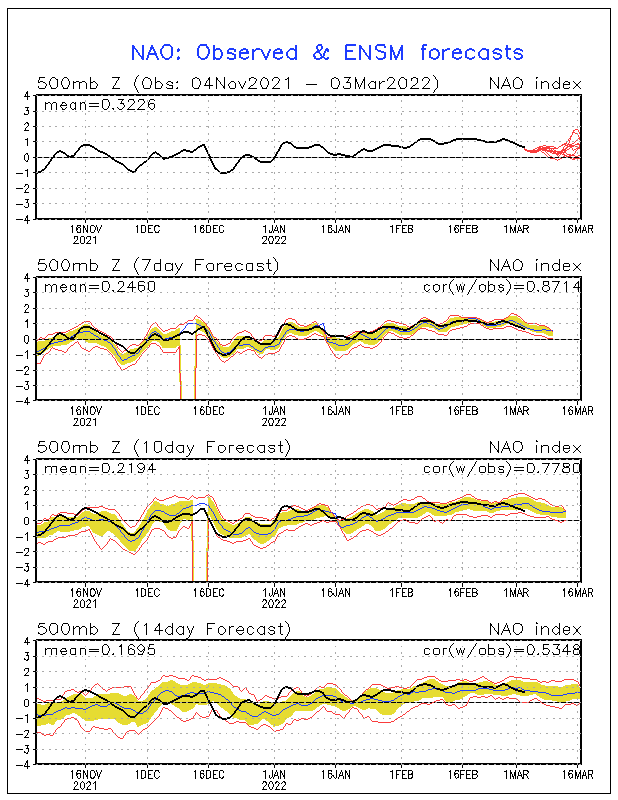
AO says I am with you!? Let due it together -nice couplet

PNA Going neutral
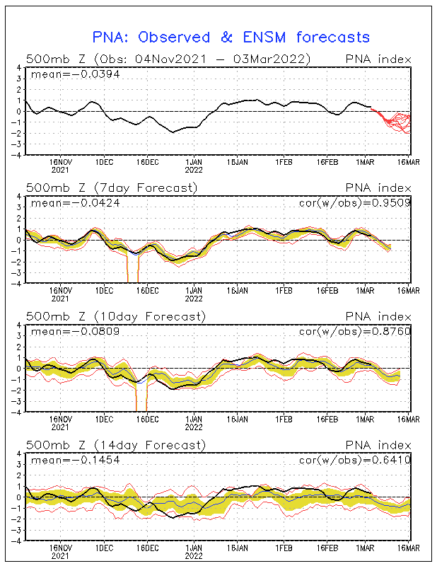
If you recall RB and I talked about this the other day when I noticed that the mjo pulse, wave was dying in phase 3 and looking to go back to 2 by months end and that the trop forcing out at the dateline would start to exert itself. we shall see but positive signs. 2009 ring a bell to anyone here??

AO says I am with you!? Let due it together -nice couplet

PNA Going neutral

If you recall RB and I talked about this the other day when I noticed that the mjo pulse, wave was dying in phase 3 and looking to go back to 2 by months end and that the trop forcing out at the dateline would start to exert itself. we shall see but positive signs. 2009 ring a bell to anyone here??
_________________
Mugs
AKA:King: Snow Weenie
Self Proclaimed
WINTER 2014-15 : 55.12" +.02 for 6 coatings (avg. 35")
WINTER 2015-16 Total - 29.8" (Avg 35")
WINTER 2016-17 : 39.5" so far

amugs- Advanced Forecaster - Mod

- Posts : 15149
Reputation : 213
Join date : 2013-01-07
Age : 54
Location : Hillsdale,NJ
 Re: Long Range Thread 8.0
Ripped from another site gfs saying Flip Baby Flip!?


_________________
Mugs
AKA:King: Snow Weenie
Self Proclaimed
WINTER 2014-15 : 55.12" +.02 for 6 coatings (avg. 35")
WINTER 2015-16 Total - 29.8" (Avg 35")
WINTER 2016-17 : 39.5" so far

amugs- Advanced Forecaster - Mod

- Posts : 15149
Reputation : 213
Join date : 2013-01-07
Age : 54
Location : Hillsdale,NJ
 Re: Long Range Thread 8.0
bring it on here. hold baby hold!!


_________________
Mugs
AKA:King: Snow Weenie
Self Proclaimed
WINTER 2014-15 : 55.12" +.02 for 6 coatings (avg. 35")
WINTER 2015-16 Total - 29.8" (Avg 35")
WINTER 2016-17 : 39.5" so far

amugs- Advanced Forecaster - Mod

- Posts : 15149
Reputation : 213
Join date : 2013-01-07
Age : 54
Location : Hillsdale,NJ
 Re: Long Range Thread 8.0
GEFS say stout northeast trough going forward and a stout block showing up as well. Nred this to stay on the next few runs fir validity.


_________________
Mugs
AKA:King: Snow Weenie
Self Proclaimed
WINTER 2014-15 : 55.12" +.02 for 6 coatings (avg. 35")
WINTER 2015-16 Total - 29.8" (Avg 35")
WINTER 2016-17 : 39.5" so far

amugs- Advanced Forecaster - Mod

- Posts : 15149
Reputation : 213
Join date : 2013-01-07
Age : 54
Location : Hillsdale,NJ
Page 33 of 40 •  1 ... 18 ... 32, 33, 34 ... 36 ... 40
Page 33 of 40
Permissions in this forum:
You cannot reply to topics in this forum
 Home
Home