
 Search
Long Range Thread 14.0
Page 2 of 14 •  1, 2, 3 ... 8 ... 14
 ![]()
Re: Long Range Thread 14.0
![]() by CPcantmeasuresnow Thu Mar 09, 2017 12:23 pm
by CPcantmeasuresnow Thu Mar 09, 2017 12:23 pm
jmanley32 wrote:12z CMC also snows bit longer nearly in line with GFS, thats a change of pace.
Wow, and remember windshield wiper I would not be surprised to see this go back to closer to inside benchmark and give us even higher totals but this is gr8.
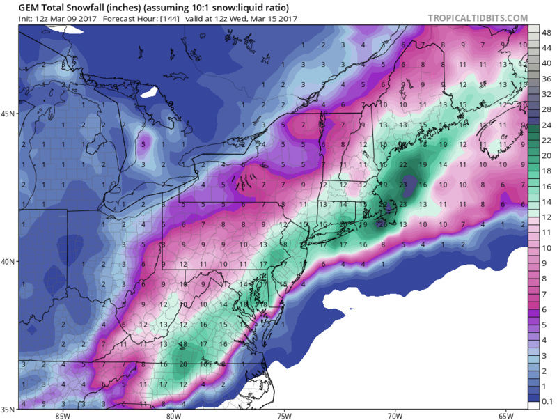
You're right Jman, the GFS and the CMC boh have exactly 15 inches right over my house. You don't often see agreement by two different models to that degree this far out. It makes me think this might actually happen.
CPcantmeasuresnow- Wx Statistician Guru

- Posts : 7274
Join date : 2013-01-07
Re: Long Range Thread 14.0
![]() by jmanley32 Thu Mar 09, 2017 12:26 pm
by jmanley32 Thu Mar 09, 2017 12:26 pm
jmanley32- Senior Enthusiast

- Posts : 20634
Join date : 2013-12-12
Re: Long Range Thread 14.0
![]() by jmanley32 Thu Mar 09, 2017 12:27 pm
by jmanley32 Thu Mar 09, 2017 12:27 pm
Please someone post the surface and then snow maps for the Euro, very excited to see what it shows, never lose hope from one run, last night was windshield, if we get to unday and things do not look good then ill be nervous. Watch this beast trend stronger and closer to coast, as frank said it has roidzilla potential, and if a triple phase occurs oh boy!

jmanley32- Senior Enthusiast
- Posts : 20634
Reputation : 108
Join date : 2013-12-12
Age : 43
Location : Yonkers, NY
Re: Long Range Thread 14.0
![]() by amugs Thu Mar 09, 2017 1:03 pm
by amugs Thu Mar 09, 2017 1:03 pm

_________________
Mugs
AKA:King: Snow Weenie
Self Proclaimed
WINTER 2014-15 : 55.12" +.02 for 6 coatings (avg. 35")
WINTER 2015-16 Total - 29.8" (Avg 35")
WINTER 2016-17 : 39.5" so far

amugs- Advanced Forecaster - Mod

- Posts : 15127
Reputation : 213
Join date : 2013-01-07
Age : 54
Location : Hillsdale,NJ
Re: Long Range Thread 14.0
![]() by billg315 Thu Mar 09, 2017 1:10 pm
by billg315 Thu Mar 09, 2017 1:10 pm

billg315- Advanced Forecaster - Mod
- Posts : 4530
Reputation : 185
Join date : 2015-01-24
Age : 50
Location : Flemington, NJ
Re: Long Range Thread 14.0
![]() by amugs Thu Mar 09, 2017 1:19 pm
by amugs Thu Mar 09, 2017 1:19 pm
PNA spike - LP dropping down - Moisture slug in the gulf - 50/50 low- NAO block
_________________
Mugs
AKA:King: Snow Weenie
Self Proclaimed
WINTER 2014-15 : 55.12" +.02 for 6 coatings (avg. 35")
WINTER 2015-16 Total - 29.8" (Avg 35")
WINTER 2016-17 : 39.5" so far
amugs- Advanced Forecaster - Mod
- Posts : 15127
Reputation : 213
Join date : 2013-01-07
Age : 54
Location : Hillsdale,NJ
Re: Long Range Thread 14.0
![]() by amugs Thu Mar 09, 2017 1:25 pm
by amugs Thu Mar 09, 2017 1:25 pm

_________________
Mugs
AKA:King: Snow Weenie
Self Proclaimed
WINTER 2014-15 : 55.12" +.02 for 6 coatings (avg. 35")
WINTER 2015-16 Total - 29.8" (Avg 35")
WINTER 2016-17 : 39.5" so far
amugs- Advanced Forecaster - Mod
- Posts : 15127
Reputation : 213
Join date : 2013-01-07
Age : 54
Location : Hillsdale,NJ
Re: Long Range Thread 14.0
![]() by amugs Thu Mar 09, 2017 1:26 pm
by amugs Thu Mar 09, 2017 1:26 pm
Trough much sharper and slower.
_________________
Mugs
AKA:King: Snow Weenie
Self Proclaimed
WINTER 2014-15 : 55.12" +.02 for 6 coatings (avg. 35")
WINTER 2015-16 Total - 29.8" (Avg 35")
WINTER 2016-17 : 39.5" so far
amugs- Advanced Forecaster - Mod
- Posts : 15127
Reputation : 213
Join date : 2013-01-07
Age : 54
Location : Hillsdale,NJ
Re: Long Range Thread 14.0
![]() by Frank_Wx Thu Mar 09, 2017 1:33 pm
by Frank_Wx Thu Mar 09, 2017 1:33 pm
_________________
_______________________________________________________________________________________________________
CLICK HERE to view NJ Strong Snowstorm Classifications

Frank_Wx- Godzilla Seeker

- Posts : 21308
Reputation : 328
Join date : 2013-01-05
Age : 32
Location : Jersey City, NJ -

Re: Long Range Thread 14.0
![]() by amugs Thu Mar 09, 2017 1:35 pm
by amugs Thu Mar 09, 2017 1:35 pm

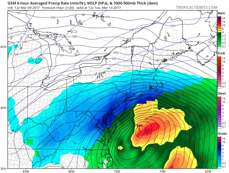
IT SNOWS FROM TUESDAY early am through Wednesday evening!!
MOMMMA MIA!!
Last edited by amugs on Thu Mar 09, 2017 1:41 pm; edited 1 time in total
_________________
Mugs
AKA:King: Snow Weenie
Self Proclaimed
WINTER 2014-15 : 55.12" +.02 for 6 coatings (avg. 35")
WINTER 2015-16 Total - 29.8" (Avg 35")
WINTER 2016-17 : 39.5" so far
amugs- Advanced Forecaster - Mod
- Posts : 15127
Reputation : 213
Join date : 2013-01-07
Age : 54
Location : Hillsdale,NJ
Re: Long Range Thread 14.0
![]() by Frank_Wx Thu Mar 09, 2017 1:36 pm
by Frank_Wx Thu Mar 09, 2017 1:36 pm
_________________
_______________________________________________________________________________________________________
CLICK HERE to view NJ Strong Snowstorm Classifications
Frank_Wx- Godzilla Seeker
- Posts : 21308
Reputation : 328
Join date : 2013-01-05
Age : 32
Location : Jersey City, NJ -
Re: Long Range Thread 14.0
![]() by nutleyblizzard Thu Mar 09, 2017 1:40 pm
by nutleyblizzard Thu Mar 09, 2017 1:40 pm
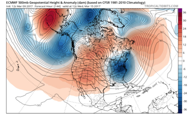
The EURO shows this too. My confidence for a major storm has increased.amugs wrote:As a young pro met showed on twitter and another board - we bridge these two - NAO/EPO/WPO - the red areas in the Canadian/Greenland region we have a LOONNNNGGG Duration event of 20 hours plus - CMC and GFS were like 30 hours long!!

nutleyblizzard- Senior Enthusiast
- Posts : 1963
Reputation : 41
Join date : 2014-01-30
Age : 58
Location : Nutley, new jersey
Re: Long Range Thread 14.0
![]() by amugs Thu Mar 09, 2017 1:43 pm
by amugs Thu Mar 09, 2017 1:43 pm
I may get banned for my mental excitement from snow deprivation such actions - LMAO!!
_________________
Mugs
AKA:King: Snow Weenie
Self Proclaimed
WINTER 2014-15 : 55.12" +.02 for 6 coatings (avg. 35")
WINTER 2015-16 Total - 29.8" (Avg 35")
WINTER 2016-17 : 39.5" so far
amugs- Advanced Forecaster - Mod
- Posts : 15127
Reputation : 213
Join date : 2013-01-07
Age : 54
Location : Hillsdale,NJ
Re: Long Range Thread 14.0
![]() by nutleyblizzard Thu Mar 09, 2017 1:49 pm
by nutleyblizzard Thu Mar 09, 2017 1:49 pm
nutleyblizzard- Senior Enthusiast
- Posts : 1963
Reputation : 41
Join date : 2014-01-30
Age : 58
Location : Nutley, new jersey
Re: Long Range Thread 14.0
![]() by sroc4 Thu Mar 09, 2017 1:51 pm
by sroc4 Thu Mar 09, 2017 1:51 pm
_________________
"In weather and in life, there's no winning and losing; there's only winning and learning."
WINTER 2012/2013 TOTALS 43.65"WINTER 2017/2018 TOTALS 62.85" WINTER 2022/2023 TOTALS 4.9"
WINTER 2013/2014 TOTALS 64.85"WINTER 2018/2019 TOTALS 14.25" WINTER 2023/2024 TOTALS 13.1"
WINTER 2014/2015 TOTALS 71.20"WINTER 2019/2020 TOTALS 6.35"
WINTER 2015/2016 TOTALS 35.00"WINTER 2020/2021 TOTALS 37.75"
WINTER 2016/2017 TOTALS 42.25"WINTER 2021/2022 TOTALS 31.65"

sroc4- Admin
- Posts : 8438
Reputation : 302
Join date : 2013-01-07
Location : Wading River, LI
Re: Long Range Thread 14.0
![]() by sroc4 Thu Mar 09, 2017 1:52 pm
by sroc4 Thu Mar 09, 2017 1:52 pm
nutleyblizzard wrote:EURO was very close to a historic run. Big improvements with the upper levels nonetheless. Good place to be right now.
Great place to be for sure. Euro conts to bring the timing of these pieces closer and closer.
_________________
"In weather and in life, there's no winning and losing; there's only winning and learning."
WINTER 2012/2013 TOTALS 43.65"WINTER 2017/2018 TOTALS 62.85" WINTER 2022/2023 TOTALS 4.9"
WINTER 2013/2014 TOTALS 64.85"WINTER 2018/2019 TOTALS 14.25" WINTER 2023/2024 TOTALS 13.1"
WINTER 2014/2015 TOTALS 71.20"WINTER 2019/2020 TOTALS 6.35"
WINTER 2015/2016 TOTALS 35.00"WINTER 2020/2021 TOTALS 37.75"
WINTER 2016/2017 TOTALS 42.25"WINTER 2021/2022 TOTALS 31.65"
sroc4- Admin
- Posts : 8438
Reputation : 302
Join date : 2013-01-07
Location : Wading River, LI
Re: Long Range Thread 14.0
![]() by Frank_Wx Thu Mar 09, 2017 1:59 pm
by Frank_Wx Thu Mar 09, 2017 1:59 pm
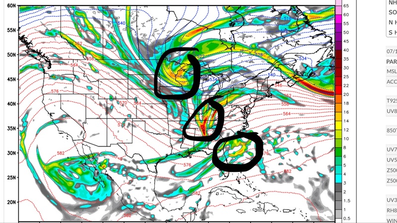
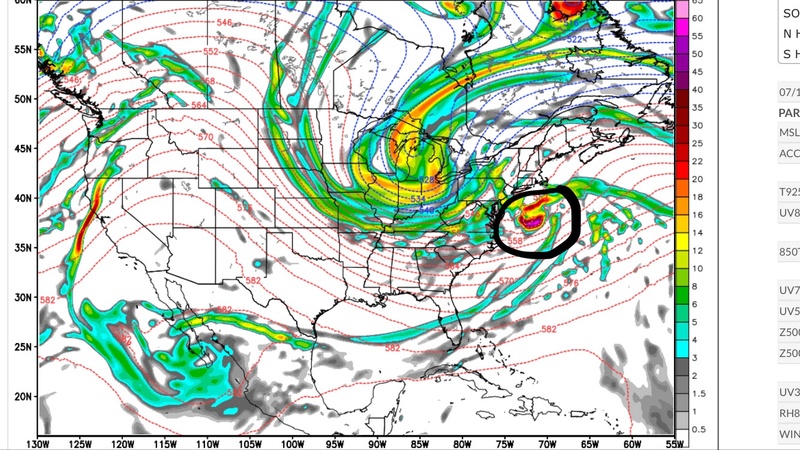
sroc4 wrote:Just look at this set up! Three bundles of energy from three branches of the Jet. Polar, PAC, STJ. If these come together just right, like Frank said Frankzilla potential, AKA BECS.
Using this image for Twitter. You have no say in this matter. Thanks.

_________________
_______________________________________________________________________________________________________
CLICK HERE to view NJ Strong Snowstorm Classifications
Frank_Wx- Godzilla Seeker
- Posts : 21308
Reputation : 328
Join date : 2013-01-05
Age : 32
Location : Jersey City, NJ -
Re: Long Range Thread 14.0
![]() by amugs Thu Mar 09, 2017 1:59 pm
by amugs Thu Mar 09, 2017 1:59 pm
Even without the full threesome it snowed for 30 plus hours on the Euro - imagine of it does and 18 of those where moderate to heavy!
_________________
Mugs
AKA:King: Snow Weenie
Self Proclaimed
WINTER 2014-15 : 55.12" +.02 for 6 coatings (avg. 35")
WINTER 2015-16 Total - 29.8" (Avg 35")
WINTER 2016-17 : 39.5" so far
amugs- Advanced Forecaster - Mod
- Posts : 15127
Reputation : 213
Join date : 2013-01-07
Age : 54
Location : Hillsdale,NJ
Re: Long Range Thread 14.0
![]() by billg315 Thu Mar 09, 2017 2:03 pm
by billg315 Thu Mar 09, 2017 2:03 pm
billg315- Advanced Forecaster - Mod
- Posts : 4530
Reputation : 185
Join date : 2015-01-24
Age : 50
Location : Flemington, NJ
Re: Long Range Thread 14.0
![]() by jake732 Thu Mar 09, 2017 2:09 pm
by jake732 Thu Mar 09, 2017 2:09 pm

jake732- Pro Enthusiast

- Posts : 449
Reputation : 0
Join date : 2016-01-03
Location : lakewood, nj -
Re: Long Range Thread 14.0
![]() by sroc4 Thu Mar 09, 2017 2:09 pm
by sroc4 Thu Mar 09, 2017 2:09 pm
Frank_Wx wrote:sroc4 wrote:Just look at this set up! Three bundles of energy from three branches of the Jet. Polar, PAC, STJ. If these come together just right, like Frank said Frankzilla potential, AKA BECS.
Using this image for Twitter. You have no say in this matter. Thanks.
LOL Frank...but but.....
Last edited by sroc4 on Thu Mar 09, 2017 2:14 pm; edited 1 time in total
_________________
"In weather and in life, there's no winning and losing; there's only winning and learning."
WINTER 2012/2013 TOTALS 43.65"WINTER 2017/2018 TOTALS 62.85" WINTER 2022/2023 TOTALS 4.9"
WINTER 2013/2014 TOTALS 64.85"WINTER 2018/2019 TOTALS 14.25" WINTER 2023/2024 TOTALS 13.1"
WINTER 2014/2015 TOTALS 71.20"WINTER 2019/2020 TOTALS 6.35"
WINTER 2015/2016 TOTALS 35.00"WINTER 2020/2021 TOTALS 37.75"
WINTER 2016/2017 TOTALS 42.25"WINTER 2021/2022 TOTALS 31.65"
sroc4- Admin
- Posts : 8438
Reputation : 302
Join date : 2013-01-07
Location : Wading River, LI
Re: Long Range Thread 14.0
![]() by jmanley32 Thu Mar 09, 2017 2:09 pm
by jmanley32 Thu Mar 09, 2017 2:09 pm
Is that why it looks like the heaviest precip is offshore? I am not go get greedy and believe it would be a frankzilla but is there stilla a decent change this can go roid? And your not saying its impossible to become a frankzilla? I can't wait to read your writeup tonight. Just one question i'd like for you to answer now is I have a mandatory meeting at 3pm Tues, would you recommend I try to move it to Monday, because I probably can.Frank_Wx wrote:There is some convective feedback on the models. That is when you know this storm is very powerful. Many branches of energy getting involved. If it all came together, it's a Frankzilla. But I think we're looking at a strong Godzilla here. Again, will have a blog later tonight. Like 10pm.
jmanley32- Senior Enthusiast
- Posts : 20634
Reputation : 108
Join date : 2013-12-12
Age : 43
Location : Yonkers, NY
Re: Long Range Thread 14.0
![]() by Frank_Wx Thu Mar 09, 2017 2:12 pm
by Frank_Wx Thu Mar 09, 2017 2:12 pm
jmanley32 wrote:Is that why it looks like the heaviest precip is offshore? I am not go get greedy and believe it would be a frankzilla but is there stilla a decent change this can go roid? And your not saying its impossible to become a frankzilla? I can't wait to read your writeup tonight. Just one question i'd like for you to answer now is I have a mandatory meeting at 3pm Tues, would you recommend I try to move it to Monday, because I probably can.Frank_Wx wrote:There is some convective feedback on the models. That is when you know this storm is very powerful. Many branches of energy getting involved. If it all came together, it's a Frankzilla. But I think we're looking at a strong Godzilla here. Again, will have a blog later tonight. Like 10pm.
Why risk anything. Yes, move the meeting.
_________________
_______________________________________________________________________________________________________
CLICK HERE to view NJ Strong Snowstorm Classifications
Frank_Wx- Godzilla Seeker
- Posts : 21308
Reputation : 328
Join date : 2013-01-05
Age : 32
Location : Jersey City, NJ -
Re: Long Range Thread 14.0
![]() by sroc4 Thu Mar 09, 2017 2:13 pm
by sroc4 Thu Mar 09, 2017 2:13 pm
jake732 wrote:can anyone explain y cnj on south on the euro has sooo much less snow then gfs and cmc?? almost a stupid storm for u according to euro
Watching 500mb frame by frame starting from 108 it appears the southern two bundles of energy phase whereas the polar energy is a tad late to the party. Because of this the main surface reflection is east of the BM.
Last edited by sroc4 on Thu Mar 09, 2017 2:15 pm; edited 1 time in total
_________________
"In weather and in life, there's no winning and losing; there's only winning and learning."
WINTER 2012/2013 TOTALS 43.65"WINTER 2017/2018 TOTALS 62.85" WINTER 2022/2023 TOTALS 4.9"
WINTER 2013/2014 TOTALS 64.85"WINTER 2018/2019 TOTALS 14.25" WINTER 2023/2024 TOTALS 13.1"
WINTER 2014/2015 TOTALS 71.20"WINTER 2019/2020 TOTALS 6.35"
WINTER 2015/2016 TOTALS 35.00"WINTER 2020/2021 TOTALS 37.75"
WINTER 2016/2017 TOTALS 42.25"WINTER 2021/2022 TOTALS 31.65"
sroc4- Admin
- Posts : 8438
Reputation : 302
Join date : 2013-01-07
Location : Wading River, LI
Re: Long Range Thread 14.0
![]() by billg315 Thu Mar 09, 2017 2:13 pm
by billg315 Thu Mar 09, 2017 2:13 pm
jmanley32 wrote:Is that why it looks like the heaviest precip is offshore? I am not go get greedy and believe it would be a frankzilla but is there stilla a decent change this can go roid? And your not saying its impossible to become a frankzilla? I can't wait to read your writeup tonight. Just one question i'd like for you to answer now is I have a mandatory meeting at 3pm Tues, would you recommend I try to move it to Monday, because I probably can.Frank_Wx wrote:There is some convective feedback on the models. That is when you know this storm is very powerful. Many branches of energy getting involved. If it all came together, it's a Frankzilla. But I think we're looking at a strong Godzilla here. Again, will have a blog later tonight. Like 10pm.
Why not? We know the weather is fine for Monday. There is a chance of a major storm paralyzing the region Tuesday. And even if it "misses" we probably still get some inclement weather. Better safe than sorry.
billg315- Advanced Forecaster - Mod
- Posts : 4530
Reputation : 185
Join date : 2015-01-24
Age : 50
Location : Flemington, NJ
Re: Long Range Thread 14.0
![]() by jmanley32 Thu Mar 09, 2017 2:14 pm
by jmanley32 Thu Mar 09, 2017 2:14 pm
When was the last time I heard any of you mention even the possibility of a BECS, never maybe the big letdown of Juno, but my excitment is growing, but I am still being cautious till we are around sat. That is an amazing setup and I wonder how the blizzard of 1993 looked at that hour out, 3 pieces? Hopefully it CAN all come together to give us all a wet dream snowstorm. LOL we track as you say!sroc4 wrote:Just look at this set up! Three bundles of energy from three branches of the Jet. Polar, PAC, STJ. If these come together just right, like Frank said Frankzilla potential, AKA BECS.
jmanley32- Senior Enthusiast
- Posts : 20634
Reputation : 108
Join date : 2013-12-12
Age : 43
Location : Yonkers, NY
Re: Long Range Thread 14.0
![]() by Guest Thu Mar 09, 2017 2:18 pm
by Guest Thu Mar 09, 2017 2:18 pm
Should I get the milk and bread?
Guest- Guest
Page 2 of 14 • 1, 2, 3 ... 8 ... 14 ![]()
|
|
|