
 Search
2017 General Tropical Cyclone Discussion Thread
Page 5 of 40 •  1, 2, 3, 4, 5, 6 ... 22 ... 40
 ![]()
Re: 2017 General Tropical Cyclone Discussion Thread
![]() by Snow88 Fri Aug 04, 2017 10:06 pm
by Snow88 Fri Aug 04, 2017 10:06 pm
Snow88- Senior Enthusiast

- Posts : 2193
Join date : 2013-01-09
Re: 2017 General Tropical Cyclone Discussion Thread
![]() by sroc4 Sat Aug 05, 2017 10:14 am
by sroc4 Sat Aug 05, 2017 10:14 am

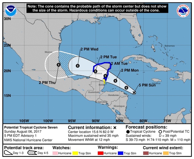
Briefly regarding 90L. Shear, and the close proximity to the S American coastline remains the key inhibiting factors for its development. If this is to develop it likely wont until it passes over the Yukatan Penninsula and into the Bay Of Campeche (BOC). That said models have been fairly consistent in taking it on the southern periphery of the shaded area above. This would result in the likelihood for little to no further development due to land interactions and little time over open waters; however, if the track ends up on the northern periphery then rapid development is def still possible. Even with development into an organized trop system landfall would likely be Mexico, but Texas is still not out of the woods. For now in the words of Mr. Forest Gump..." That's all I have to say about that"
99L
Overall the convection surrounding 99L remains highly disorganized and spread out. This combined with dry air, and Shear on the southeast and Eastern sides of the system have really hindered any further development thus far.

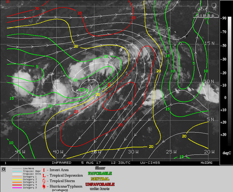
That said There remains a nice anticyclone just West of where the NHC has the center of the wave, designated I
. This anticyclone results in upper air divergence, an exhaust if you will, that promotes/enhances rising air beneath it.
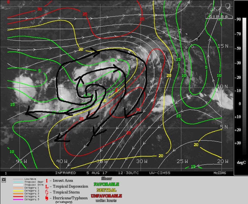
As a result of this there seems to be a little better organization and a tighter cluster of convection developing underneath this area of divergence this morning. We will have to watch this very closely for organization throughout the day as it seems to be far enough away from the shear as seen above.
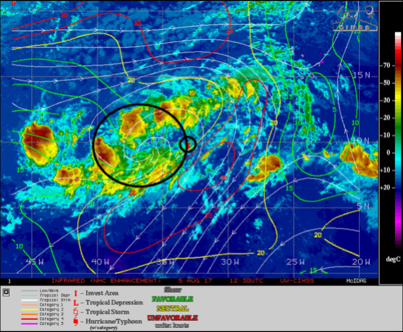
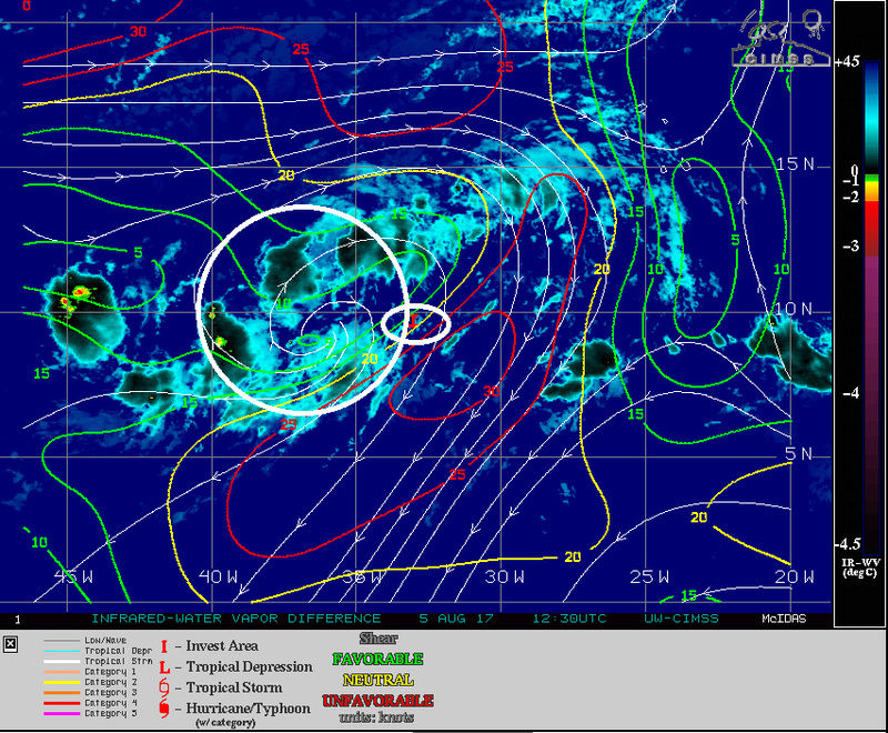

Going back to the "shear" factor looking at both GFS and Euro wind shear forecasts it actually appears that shear may increase on the southern and Easterly flanks of this area over the next 24hrs.
So although there currently appears to be some better organization near the westerly component to the wave that is 99L I suspect it will continue to be much ado about nothing.
sroc4- Admin

- Posts : 8438
Join date : 2013-01-07
Re: 2017 General Tropical Cyclone Discussion Thread
![]() by jmanley32 Sat Aug 05, 2017 7:57 pm
by jmanley32 Sat Aug 05, 2017 7:57 pm

jmanley32- Senior Enthusiast
- Posts : 20634
Reputation : 108
Join date : 2013-12-12
Age : 43
Location : Yonkers, NY
Re: 2017 General Tropical Cyclone Discussion Thread
![]() by jmanley32 Sat Aug 05, 2017 7:59 pm
by jmanley32 Sat Aug 05, 2017 7:59 pm
jmanley32- Senior Enthusiast
- Posts : 20634
Reputation : 108
Join date : 2013-12-12
Age : 43
Location : Yonkers, NY
Re: 2017 General Tropical Cyclone Discussion Thread
![]() by Math23x7 Sun Aug 06, 2017 3:15 am
by Math23x7 Sun Aug 06, 2017 3:15 am
To follow up on my remark on how the ECMWF handles storms. There is a pro/con with it. Pro: Sniffs out storms that end up occurring. Con: The specific details of the storm, including the exact location and whether or not it will phase.
Think back to Hermine. Days out, the EURO had it making landfall in Louisiana/Mississippi as a pretty sizable hurricane. It ended up making landfall in Northern Florida as a Category 1. It then had the system stalling with decent strength off the NY/NJ coast. While the low pressure did stall of the east coast, not only was it much farther away, but it did not phase, resulting in a relatively uneventful storm here.
So the signal is there but don't take the model run verbatim.
Math23x7- Wx Statistician Guru

- Posts : 2382
Reputation : 68
Join date : 2013-01-08
Re: 2017 General Tropical Cyclone Discussion Thread
![]() by sroc4 Sun Aug 06, 2017 11:09 am
by sroc4 Sun Aug 06, 2017 11:09 am

As far as 99L is concerned, yess as Mike pointed out above the Euro now has the system developed into a tropical storm just off the SE coast by the end of its run at hr 240. To cont beating a dead horse I will reiterate that the Euro is by far the best global model when it comes to handling the tropics. That said we should still be wary of any model beyond 3-5days, esp when the system isn't formed yet, and even more ESP when the system is an exceptionally broad disorganized area of convection and vorticity as 99L continues to be. When there is a broad area of vorticity in the low and mid levels, and an open wave at the surface it is very easy for any model to initialize the center of the system in the wrong location.
The 3 main reasons 99L has not developed further as was forecasted by the GFS, and 75% or more of the supposed "hurricane models" (remember 3 days ago it was supposed to be at least a depression if not trop storm by this morning) is because 1) 99L was always a broad area of convection which almost always takes more time than expected for it consolidate such that it can become self sustaining in large part because... 2) They failed to recognize the significance that the SAL was going to have on the system. A more compact system that can get convection centered over the main area of low level spin will have a better chance at mixing the dry air out, and getting the engine fired up and self sustaining. Unfort SAL will cont to be a major hindrance for at least the next 2weeks in the MDR(Main Development Region) to any tropical wave no matter how strong it is coming off the African coast. 3) There was stronger shear on the south and east sides of the system from the get go and continues to be present at the time of this writing.
All this said in no way should we sleep on 99L. For now for the next 3-5days it appears that the inhibitory factors are over coming the more favorable conditions, so significant development is unlikely at this time, but This is not a forgone conclusion. If the shear lets up there is a really nice anticyclone centered over top 99L which could def allow for slow development.

Look below and see the Euros latest MSLP anomaly maps. As you can see I have broken down the tropics into 2 main zones. The area between the West African coast and the Eastern Caribbean, AKA the MDR, is all open waters with zero land interactions and needing to contend with the SAL. My point here is some of the environmental conditions that will be enhancing or inhibitory within either of these two "zones" will be different. Once a wave or developed system reaches the 60W longitude, which is about where the Lesser Antilles are located we get our first potential interactions with various islands.
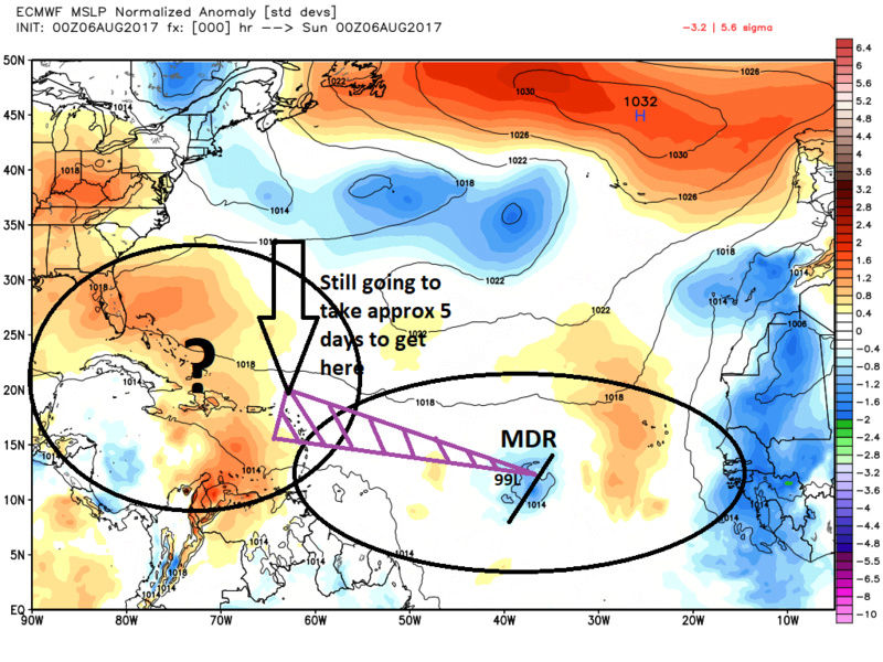
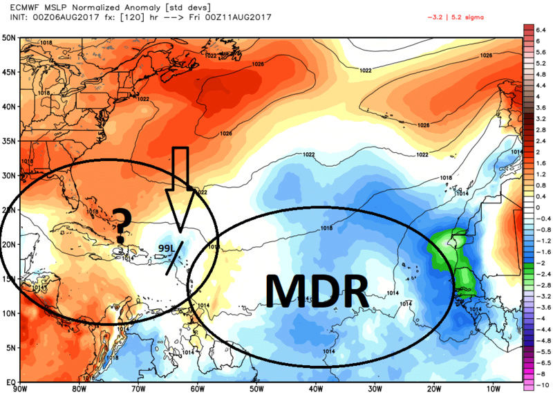
So the exact track of 99L over the next 5days will have implications on what happens next. A track into the Caribbean ocean, directly over the Greater Antilles Island chain, or north of the islands all will have implications on happens next. Sooooooooooooooooooooo............

Don't trust any model right now beyond 5-7 days regarding 99L,(although I certainly raise an eyebrow more so when the euro shows something significant in the long range), but realize it will remain a threat to the US until the wave is caught up in the westerly's and is somewhere over Europe.
_________________
"In weather and in life, there's no winning and losing; there's only winning and learning."
WINTER 2012/2013 TOTALS 43.65"WINTER 2017/2018 TOTALS 62.85" WINTER 2022/2023 TOTALS 4.9"
WINTER 2013/2014 TOTALS 64.85"WINTER 2018/2019 TOTALS 14.25" WINTER 2023/2024 TOTALS 13.1"
WINTER 2014/2015 TOTALS 71.20"WINTER 2019/2020 TOTALS 6.35"
WINTER 2015/2016 TOTALS 35.00"WINTER 2020/2021 TOTALS 37.75"
WINTER 2016/2017 TOTALS 42.25"WINTER 2021/2022 TOTALS 31.65"

sroc4- Admin
- Posts : 8438
Reputation : 302
Join date : 2013-01-07
Location : Wading River, LI
Re: 2017 General Tropical Cyclone Discussion Thread
![]() by jmanley32 Sun Aug 06, 2017 4:42 pm
by jmanley32 Sun Aug 06, 2017 4:42 pm
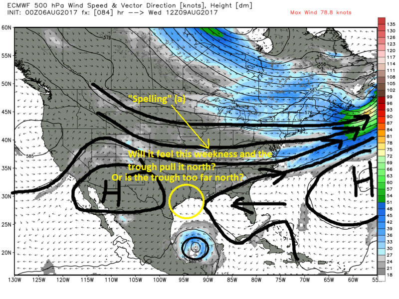
sroc4 wrote:Quick word on 90L. Whether it be east of the Yucatan peninsula or once it enters the BOC, it continues to look like it will be our next named storm. Model consensus on track still highly favors a track into Mexico. That said there is a way it can come north. Take a look at the 500mb euro images below. As you can see by about 12z Wed the system has moved over the Yukatan Penninsula and into the open waters of the BOC. If the longwave trough is sharper or deeper, and/or the center of the system is further north by this time frame there is a chance the system can feel the tug by the longwave trough and come north before the building ridge takes over and steers it west once again. By the looks of it it seems that the timing of the trough and how deep it is compared to when the system enters the BOC is such that it will likely miss the connection and again a Mexico landfall is most likely. That said the SE Texas coast should cont to monitor things closely as we are now in the 3-5day time frame.
As far as 99L is concerned, yess as Mike pointed out above the Euro now has the system developed into a tropical storm just off the SE coast by the end of its run at hr 240. To cont beating a dead horse I will reiterate that the Euro is by far the best global model when it comes to handling the tropics. That said we should still be wary of any model beyond 3-5days, esp when the system isn't formed yet, and even more ESP when the system is an exceptionally broad disorganized area of convection and vorticity as 99L continues to be. When there is a broad area of vorticity in the low and mid levels, and an open wave at the surface it is very easy for any model to initialize the center of the system in the wrong location.
The 3 main reasons 99L has not developed further as was forecasted by the GFS, and 75% or more of the supposed "hurricane models" (remember 3 days ago it was supposed to be at least a depression if not trop storm by this morning) is because 1) 99L was always a broad area of convection which almost always takes more time than expected for it consolidate such that it can become self sustaining in large part because... 2) They failed to recognize the significance that the SAL was going to have on the system. A more compact system that can get convection centered over the main area of low level spin will have a better chance at mixing the dry air out, and getting the engine fired up and self sustaining. Unfort SAL will cont to be a major hindrance for at least the next 2weeks in the MDR(Main Development Region) to any tropical wave no matter how strong it is coming off the African coast. 3) There was stronger shear on the south and east sides of the system from the get go and continues to be present at the time of this writing.
All this said in no way should we sleep on 99L. For now for the next 3-5days it appears that the inhibitory factors are over coming the more favorable conditions, so significant development is unlikely at this time, but This is not a forgone conclusion. If the shear lets up there is a really nice anticyclone centered over top 99L which could def allow for slow development.
Look below and see the Euros latest MSLP anomaly maps. As you can see I have broken down the tropics into 2 main zones. The area between the West African coast and the Eastern Caribbean, AKA the MDR, is all open waters with zero land interactions and needing to contend with the SAL. My point here is some of the environmental conditions that will be enhancing or inhibitory within either of these two "zones" will be different. Once a wave or developed system reaches the 60W longitude, which is about where the Lesser Antilles are located we get our first potential interactions with various islands.
So the exact track of 99L over the next 5days will have implications on what happens next. A track into the Caribbean ocean, directly over the Greater Antilles Island chain, or north of the islands all will have implications on happens next. Sooooooooooooooooooooo............
Don't trust any model right now beyond 5-7 days regarding 99L,(although I certainly raise an eyebrow more so when the euro shows something significant in the long range), but realize it will remain a threat to the US until the wave is caught up in the westerly's and is somewhere over Europe.
90l is a td and will be our next ts and possible hurricane in boc. 99l looks sad and nhc losing confidence. euro also dropped the development, as sroc said many days to watch 99l.
jmanley32- Senior Enthusiast
- Posts : 20634
Reputation : 108
Join date : 2013-12-12
Age : 43
Location : Yonkers, NY
Re: 2017 General Tropical Cyclone Discussion Thread
![]() by amugs Sun Aug 06, 2017 5:26 pm
by amugs Sun Aug 06, 2017 5:26 pm
At the shore at my sisters IN Belmar last few days. Catching up on here now.
90Lbecomes the next names trop cyclone.
99L has as Scott pointed out in detail a few factors to overcome. Now with that being saI'd he also pointed out the fact that all that wave has to do is get out of the MDR region and then it will have less factors hindering it's development. Still lots of time. Check out this map I founderstand on tweeter.
_________________
Mugs
AKA:King: Snow Weenie
Self Proclaimed
WINTER 2014-15 : 55.12" +.02 for 6 coatings (avg. 35")
WINTER 2015-16 Total - 29.8" (Avg 35")
WINTER 2016-17 : 39.5" so far

amugs- Advanced Forecaster - Mod

- Posts : 15127
Reputation : 213
Join date : 2013-01-07
Age : 54
Location : Hillsdale,NJ
Re: 2017 General Tropical Cyclone Discussion Thread
![]() by amugs Sun Aug 06, 2017 5:39 pm
by amugs Sun Aug 06, 2017 5:39 pm
_________________
Mugs
AKA:King: Snow Weenie
Self Proclaimed
WINTER 2014-15 : 55.12" +.02 for 6 coatings (avg. 35")
WINTER 2015-16 Total - 29.8" (Avg 35")
WINTER 2016-17 : 39.5" so far
amugs- Advanced Forecaster - Mod
- Posts : 15127
Reputation : 213
Join date : 2013-01-07
Age : 54
Location : Hillsdale,NJ
Re: 2017 General Tropical Cyclone Discussion Thread
![]() by rb924119 Sun Aug 06, 2017 5:52 pm
by rb924119 Sun Aug 06, 2017 5:52 pm
rb924119- Meteorologist

- Posts : 7033
Reputation : 195
Join date : 2013-02-06
Age : 32
Location : Greentown, Pa
Re: 2017 General Tropical Cyclone Discussion Thread
![]() by rb924119 Mon Aug 07, 2017 4:50 am
by rb924119 Mon Aug 07, 2017 4:50 am
rb924119- Meteorologist
- Posts : 7033
Reputation : 195
Join date : 2013-02-06
Age : 32
Location : Greentown, Pa
Re: 2017 General Tropical Cyclone Discussion Thread
![]() by skinsfan1177 Mon Aug 07, 2017 8:24 am
by skinsfan1177 Mon Aug 07, 2017 8:24 am

skinsfan1177- Senior Enthusiast
- Posts : 4485
Reputation : 35
Join date : 2013-01-07
Age : 46
Location : Point Pleasant Boro
Re: 2017 General Tropical Cyclone Discussion Thread
![]() by gigs68 Mon Aug 07, 2017 8:48 am
by gigs68 Mon Aug 07, 2017 8:48 am
skinsfan1177 wrote:What's BOC stand for?
Bay of Campeche

gigs68- Posts : 142
Reputation : 3
Join date : 2013-01-16
Location : Commack, NY (NW Suffolk)
Re: 2017 General Tropical Cyclone Discussion Thread
![]() by jmanley32 Mon Aug 07, 2017 8:53 am
by jmanley32 Mon Aug 07, 2017 8:53 am
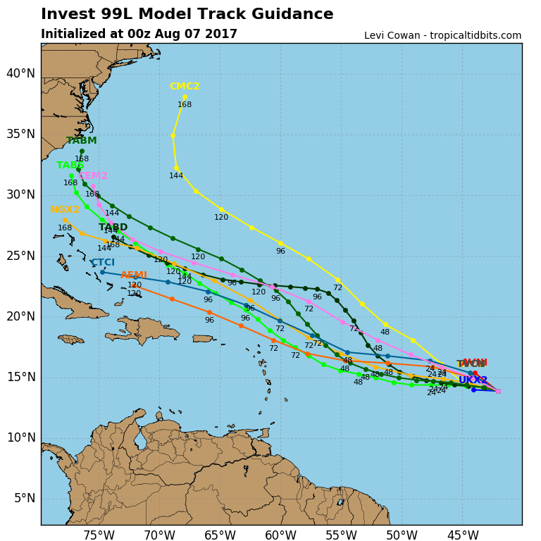
Don't toy with me lol, CMC right now is only one that shows it blowing up and having a near miss. All models do show a kink in the lines showing a open wave but nothing materializes, when do you think the models may catch onto your idea? This by no means is bashing but so far you guys have been spot on over the NHC, you and sroc need apply for head jobs there.rb924119 wrote:Whatever the name of that Invest area in the MDR, it has caught my attention. Not because of what it's (not) going to do this week as it treks across the Atlantic, as discussed by Scott, but because of the potential it has once it gets nearer the Bahamas later this weekend and early next week. I'm mildly entertained by the setup, and think it will have a decent chance to quickly organize/deepen and parallel the East Coast as a named system. Long way to go, though.
jmanley32- Senior Enthusiast
- Posts : 20634
Reputation : 108
Join date : 2013-12-12
Age : 43
Location : Yonkers, NY
Re: 2017 General Tropical Cyclone Discussion Thread
![]() by jmanley32 Mon Aug 07, 2017 8:56 am
by jmanley32 Mon Aug 07, 2017 8:56 am
jmanley32- Senior Enthusiast
- Posts : 20634
Reputation : 108
Join date : 2013-12-12
Age : 43
Location : Yonkers, NY
Re: 2017 General Tropical Cyclone Discussion Thread
![]() by sroc4 Mon Aug 07, 2017 9:44 am
by sroc4 Mon Aug 07, 2017 9:44 am
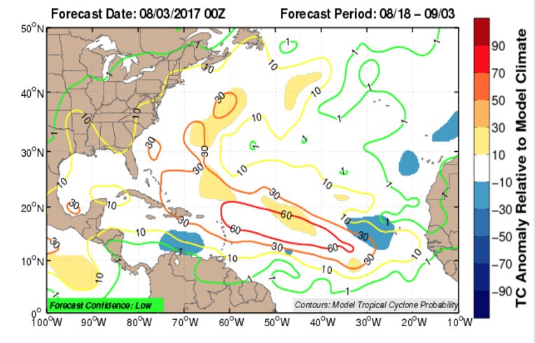
jmanley32 wrote:Don't toy with me lol, CMC right now is only one that shows it blowing up and having a near miss. All models do show a kink in the lines showing a open wave but nothing materializes, when do you think the models may catch onto your idea? This by no means is bashing but so far you guys have been spot on over the NHC, you and sroc need apply for head jobs there.rb924119 wrote:Whatever the name of that Invest area in the MDR, it has caught my attention. Not because of what it's (not) going to do this week as it treks across the Atlantic, as discussed by Scott, but because of the potential it has once it gets nearer the Bahamas later this weekend and early next week. I'm mildly entertained by the setup, and think it will have a decent chance to quickly organize/deepen and parallel the East Coast as a named system. Long way to go, though.
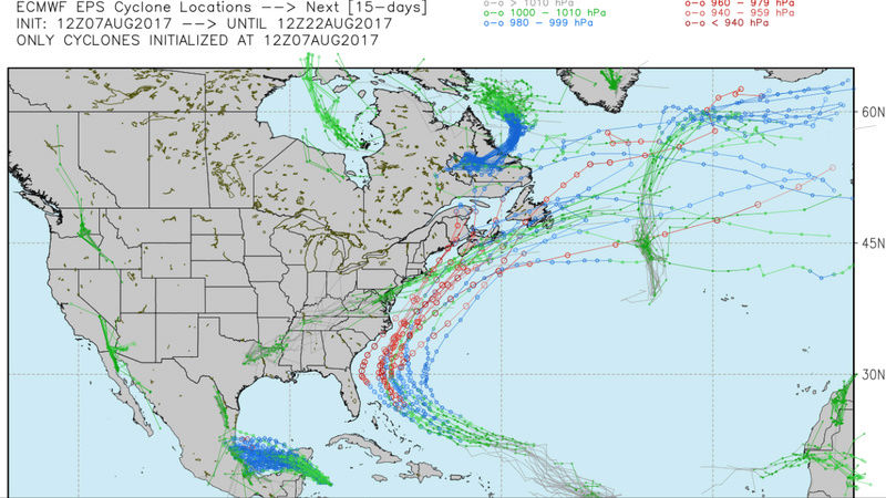
Jman Looking at this map I posted yesterday................
I would say lets see what 99L looks like and where exactly it ends up when it reaches this longitude. Only then can we look to see what the conditions are surrounding it, out ahead of it, and what it looks like up and down the east coast. I would say as of now modeling is hinting at a 500mb pattern that would likely cause it to recurve. IE: 500MB Atlantic Ridge weakness along the EC as a potent longwave positively oriented trough approaching the east coast such that any system, wave or fully, would likely feel the effects of said trough and be pulled quickly N and get caught up in the westerlies.


But of course the pudding is in the details, and those details are still obv subject to change.
_________________
"In weather and in life, there's no winning and losing; there's only winning and learning."
WINTER 2012/2013 TOTALS 43.65"WINTER 2017/2018 TOTALS 62.85" WINTER 2022/2023 TOTALS 4.9"
WINTER 2013/2014 TOTALS 64.85"WINTER 2018/2019 TOTALS 14.25" WINTER 2023/2024 TOTALS 13.1"
WINTER 2014/2015 TOTALS 71.20"WINTER 2019/2020 TOTALS 6.35"
WINTER 2015/2016 TOTALS 35.00"WINTER 2020/2021 TOTALS 37.75"
WINTER 2016/2017 TOTALS 42.25"WINTER 2021/2022 TOTALS 31.65"
sroc4- Admin
- Posts : 8438
Reputation : 302
Join date : 2013-01-07
Location : Wading River, LI
Re: 2017 General Tropical Cyclone Discussion Thread
![]() by weatherwatchermom Mon Aug 07, 2017 11:17 am
by weatherwatchermom Mon Aug 07, 2017 11:17 am
sroc4 wrote:jmanley32 wrote:Don't toy with me lol, CMC right now is only one that shows it blowing up and having a near miss. All models do show a kink in the lines showing a open wave but nothing materializes, when do you think the models may catch onto your idea? This by no means is bashing but so far you guys have been spot on over the NHC, you and sroc need apply for head jobs there.rb924119 wrote:Whatever the name of that Invest area in the MDR, it has caught my attention. Not because of what it's (not) going to do this week as it treks across the Atlantic, as discussed by Scott, but because of the potential it has once it gets nearer the Bahamas later this weekend and early next week. I'm mildly entertained by the setup, and think it will have a decent chance to quickly organize/deepen and parallel the East Coast as a named system. Long way to go, though.
Jman Looking at this map I posted yesterday................
I would say lets see what 99L looks like and where exactly it ends up when it reaches this longitude. Only then can we look to see what the conditions are surrounding it, out ahead of it, and what it looks like up and down the east coast. I would say as of now modeling is hinting at a 500mb pattern that would likely cause it to recurve. IE: 500MB Atlantic Ridge weakness along the EC as a potent longwave positively oriented trough approaching the east coast such that any system, wave or fully, would likely feel the effects of said trough and be pulled quickly N and get caught up in the westerlies.
But of course the pudding is in the details, and those details are still obv subject to change.
Thanks Sroc

weatherwatchermom- Senior Enthusiast
- Posts : 3866
Reputation : 78
Join date : 2014-11-25
Location : Hazlet Township, NJ
Re: 2017 General Tropical Cyclone Discussion Thread
![]() by weatherwatchermom Mon Aug 07, 2017 11:19 am
by weatherwatchermom Mon Aug 07, 2017 11:19 am
rb924119 wrote:Whatever the name of that Invest area in the MDR, it has caught my attention. Not because of what it's (not) going to do this week as it treks across the Atlantic, as discussed by Scott, but because of the potential it has once it gets nearer the Bahamas later this weekend and early next week. I'm mildly entertained by the setup, and think it will have a decent chance to quickly organize/deepen and parallel the East Coast as a named system. Long way to go, though.
tx rb....I hope you a least get some time to enjoy the summer!
weatherwatchermom- Senior Enthusiast
- Posts : 3866
Reputation : 78
Join date : 2014-11-25
Location : Hazlet Township, NJ
Re: 2017 General Tropical Cyclone Discussion Thread
![]() by rb924119 Mon Aug 07, 2017 12:05 pm
by rb924119 Mon Aug 07, 2017 12:05 pm
And thanks, mom!!
rb924119- Meteorologist
- Posts : 7033
Reputation : 195
Join date : 2013-02-06
Age : 32
Location : Greentown, Pa
Re: 2017 General Tropical Cyclone Discussion Thread
![]() by sroc4 Mon Aug 07, 2017 12:28 pm
by sroc4 Mon Aug 07, 2017 12:28 pm
rb924119 wrote:Agree with your thinking that a direct landfall to the East Coast is significantly less likely, Scott, which is why I used the phrase "parallel the coast". I do think it pops pretty well though, but that's just me.
And thanks, mom!!
Werd! And your welcome Weather mom!!
_________________
"In weather and in life, there's no winning and losing; there's only winning and learning."
WINTER 2012/2013 TOTALS 43.65"WINTER 2017/2018 TOTALS 62.85" WINTER 2022/2023 TOTALS 4.9"
WINTER 2013/2014 TOTALS 64.85"WINTER 2018/2019 TOTALS 14.25" WINTER 2023/2024 TOTALS 13.1"
WINTER 2014/2015 TOTALS 71.20"WINTER 2019/2020 TOTALS 6.35"
WINTER 2015/2016 TOTALS 35.00"WINTER 2020/2021 TOTALS 37.75"
WINTER 2016/2017 TOTALS 42.25"WINTER 2021/2022 TOTALS 31.65"
sroc4- Admin
- Posts : 8438
Reputation : 302
Join date : 2013-01-07
Location : Wading River, LI
Re: 2017 General Tropical Cyclone Discussion Thread
![]() by jmanley32 Mon Aug 07, 2017 3:52 pm
by jmanley32 Mon Aug 07, 2017 3:52 pm
jmanley32- Senior Enthusiast
- Posts : 20634
Reputation : 108
Join date : 2013-12-12
Age : 43
Location : Yonkers, NY

Snow88- Senior Enthusiast
- Posts : 2193
Reputation : 4
Join date : 2013-01-09
Age : 36
Location : Brooklyn, NY
Re: 2017 General Tropical Cyclone Discussion Thread
![]() by rb924119 Mon Aug 07, 2017 5:51 pm
by rb924119 Mon Aug 07, 2017 5:51 pm
rb924119- Meteorologist
- Posts : 7033
Reputation : 195
Join date : 2013-02-06
Age : 32
Location : Greentown, Pa
Re: 2017 General Tropical Cyclone Discussion Thread
![]() by jmanley32 Mon Aug 07, 2017 6:12 pm
by jmanley32 Mon Aug 07, 2017 6:12 pm
wow that gets it to cat 2 plus even far north. All stay offshore a breath of relief when and if that time came but would also love to see a huge storm. Wouldn't need much of a westward move to b a threat and a big one if the eps is right. Tons time to see and conditions can and will change. No harm meant by that sorry it's the dihard weather but in me. Is that from wxbell? I may need resubscribe soon lolrb924119 wrote:Just for you, Jman:
jmanley32- Senior Enthusiast
- Posts : 20634
Reputation : 108
Join date : 2013-12-12
Age : 43
Location : Yonkers, NY
Re: 2017 General Tropical Cyclone Discussion Thread
![]() by rb924119 Mon Aug 07, 2017 6:23 pm
by rb924119 Mon Aug 07, 2017 6:23 pm
rb924119- Meteorologist
- Posts : 7033
Reputation : 195
Join date : 2013-02-06
Age : 32
Location : Greentown, Pa
Re: 2017 General Tropical Cyclone Discussion Thread
![]() by jmanley32 Mon Aug 07, 2017 8:45 pm
by jmanley32 Mon Aug 07, 2017 8:45 pm
if and at this point I'm go say it's a huge if we got a storm to intensify sub 960 even sub 950 headed up coast into or near the area that would be really rare. It appears by that pic that even the northeast Waters would keep it intense. What would be the factors there? I know the waters have not been quite as warm. Possibly too it could be a hybrid type situation. Of course this is all speculation to a undeveloped system. Franklin may be our first hurricane.rb924119 wrote:Well, that's the one thing I would be concerned with too, is a westward shift. I could see that happening more than an eastward trend, to be honest. And no worries, buddy haha we all know what you meant. Yes, it is from WxBell.
jmanley32- Senior Enthusiast
- Posts : 20634
Reputation : 108
Join date : 2013-12-12
Age : 43
Location : Yonkers, NY
Re: 2017 General Tropical Cyclone Discussion Thread
![]() by frank 638 Mon Aug 07, 2017 9:00 pm
by frank 638 Mon Aug 07, 2017 9:00 pm
frank 638- Senior Enthusiast
- Posts : 2856
Reputation : 37
Join date : 2016-01-01
Age : 41
Location : bronx ny
Page 5 of 40 • 1, 2, 3, 4, 5, 6 ... 22 ... 40 ![]()
|
|
|