
 Search
Tracking Hurricane Irma: Part 2
Page 18 of 21 •  1 ... 10 ... 17, 18, 19, 20, 21
 ![]()
Re: Tracking Hurricane Irma: Part 2
![]() by amugs Sat Sep 09, 2017 12:45 pm
by amugs Sat Sep 09, 2017 12:45 pm
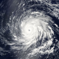
Math23x7 wrote:Janet, the 11AM advisory has Irma moving due west. If it doesn't make a northward turn anytime soon, this will go down (for Florida) as one of the biggest busts in history.
DT?? He BUSTED YUUUGGEEE!!
She is turning North and will RI, she made landfall - she is going to go to CAT 4 and possibly CAT 5.
She's improving IMO. Subsidence increasing in the eye and the IE cloud tops are increasing in height.
JB
not a full landfall hollow out the eye caseIts a disruption and likely followed by an eruption as Irma re-intensfies

amugs- Advanced Forecaster - Mod

- Posts : 15095
Join date : 2013-01-07
Re: Tracking Hurricane Irma: Part 2
![]() by WeatherBob Sat Sep 09, 2017 1:06 pm
by WeatherBob Sat Sep 09, 2017 1:06 pm
WeatherBob- Meteorologist

- Posts : 683
Join date : 2013-12-13
Re: Tracking Hurricane Irma: Part 2
![]() by GreyBeard Sat Sep 09, 2017 1:22 pm
by GreyBeard Sat Sep 09, 2017 1:22 pm
GreyBeard- Senior Enthusiast

- Posts : 725
Reputation : 34
Join date : 2014-02-12
Location : eastern nassau county
Re: Tracking Hurricane Irma: Part 2
![]() by jwalsh Sat Sep 09, 2017 1:56 pm
by jwalsh Sat Sep 09, 2017 1:56 pm
...MAJOR HURRICANE FORCE WINDS EXPECTED OVER THE FLORIDA KEYS AT
DAYBREAK...
SUMMARY OF 200 PM EDT...1800 UTC...INFORMATION
----------------------------------------------
LOCATION...23.1N 80.2W
ABOUT 65 MI...100 KM E OF VARADERO CUBA
ABOUT 145 MI...235 KM SE OF KEY WEST FLORIDA
MAXIMUM SUSTAINED WINDS...125 MPH...205 KM/H
PRESENT MOVEMENT...W OR 280 DEGREES AT 9 MPH...15 KM/H
MINIMUM CENTRAL PRESSURE...941 MB...27.79 INCHES
jwalsh- Posts : 60
Reputation : 0
Join date : 2016-01-18
Location : Commack, NY
Re: Tracking Hurricane Irma: Part 2
![]() by sroc4 Sat Sep 09, 2017 2:00 pm
by sroc4 Sat Sep 09, 2017 2:00 pm
https://m.facebook.com/story.php?story_fbid=10211815999173532&id=1176352023&fref=gc&dti=625060274303169&hc_location=ufi
_________________
"In weather and in life, there's no winning and losing; there's only winning and learning."
WINTER 2012/2013 TOTALS 43.65"WINTER 2017/2018 TOTALS 62.85" WINTER 2022/2023 TOTALS 4.9"
WINTER 2013/2014 TOTALS 64.85"WINTER 2018/2019 TOTALS 14.25" WINTER 2023/2024 TOTALS 13.1"
WINTER 2014/2015 TOTALS 71.20"WINTER 2019/2020 TOTALS 6.35"
WINTER 2015/2016 TOTALS 35.00"WINTER 2020/2021 TOTALS 37.75"
WINTER 2016/2017 TOTALS 42.25"WINTER 2021/2022 TOTALS 31.65"

sroc4- Admin

- Posts : 8390
Reputation : 302
Join date : 2013-01-07
Location : Wading River, LI
Re: Tracking Hurricane Irma: Part 2
![]() by Frank_Wx Sat Sep 09, 2017 2:10 pm
by Frank_Wx Sat Sep 09, 2017 2:10 pm

_________________
_______________________________________________________________________________________________________
CLICK HERE to view NJ Strong Snowstorm Classifications

Frank_Wx- Godzilla Seeker
- Posts : 21305
Reputation : 328
Join date : 2013-01-05
Age : 32
Location : Jersey City, NJ -

Re: Tracking Hurricane Irma: Part 2
![]() by GreyBeard Sat Sep 09, 2017 2:39 pm
by GreyBeard Sat Sep 09, 2017 2:39 pm
Frank_Wx wrote:North she goes
2:00 reading from NHC says she is moving WEST at 9mph. What do you see that they don't?
GreyBeard- Senior Enthusiast
- Posts : 725
Reputation : 34
Join date : 2014-02-12
Location : eastern nassau county
Re: Tracking Hurricane Irma: Part 2
![]() by gigs68 Sat Sep 09, 2017 2:46 pm
by gigs68 Sat Sep 09, 2017 2:46 pm
sroc4 wrote:Crazy video:
https://m.facebook.com/story.php?story_fbid=10211815999173532&id=1176352023&fref=gc&dti=625060274303169&hc_location=ufi
So can someone explain where the Ocean is. Figured it would be flooded

gigs68- Posts : 142
Reputation : 3
Join date : 2013-01-16
Location : Commack, NY (NW Suffolk)
Re: Tracking Hurricane Irma: Part 2
![]() by WeatherBob Sat Sep 09, 2017 2:50 pm
by WeatherBob Sat Sep 09, 2017 2:50 pm

WeatherBob- Meteorologist
- Posts : 683
Reputation : 83
Join date : 2013-12-13
Location : Caldwell, NJ - NW Essex County - Altitude 500 FT
Re: Tracking Hurricane Irma: Part 2
![]() by WeatherBob Sat Sep 09, 2017 2:59 pm
by WeatherBob Sat Sep 09, 2017 2:59 pm
WeatherBob- Meteorologist
- Posts : 683
Reputation : 83
Join date : 2013-12-13
Location : Caldwell, NJ - NW Essex County - Altitude 500 FT
Re: Tracking Hurricane Irma: Part 2
![]() by amugs Sat Sep 09, 2017 3:08 pm
by amugs Sat Sep 09, 2017 3:08 pm
Charlie is a great example of how RI can happen in a short span of time
_________________
Mugs
AKA:King: Snow Weenie
Self Proclaimed
WINTER 2014-15 : 55.12" +.02 for 6 coatings (avg. 35")
WINTER 2015-16 Total - 29.8" (Avg 35")
WINTER 2016-17 : 39.5" so far

amugs- Advanced Forecaster - Mod
- Posts : 15095
Reputation : 213
Join date : 2013-01-07
Age : 54
Location : Hillsdale,NJ
Re: Tracking Hurricane Irma: Part 2
![]() by sroc4 Sat Sep 09, 2017 3:36 pm
by sroc4 Sat Sep 09, 2017 3:36 pm
gigs68 wrote:sroc4 wrote:Crazy video:
https://m.facebook.com/story.php?story_fbid=10211815999173532&id=1176352023&fref=gc&dti=625060274303169&hc_location=ufi
So can someone explain where the Ocean is. Figured it would be flooded
This is likely in the wake of the storm. Low tide to go along with the storm surge pulling all the water out ahead of it. Thats my guess anyway.
_________________
"In weather and in life, there's no winning and losing; there's only winning and learning."
WINTER 2012/2013 TOTALS 43.65"WINTER 2017/2018 TOTALS 62.85" WINTER 2022/2023 TOTALS 4.9"
WINTER 2013/2014 TOTALS 64.85"WINTER 2018/2019 TOTALS 14.25" WINTER 2023/2024 TOTALS 13.1"
WINTER 2014/2015 TOTALS 71.20"WINTER 2019/2020 TOTALS 6.35"
WINTER 2015/2016 TOTALS 35.00"WINTER 2020/2021 TOTALS 37.75"
WINTER 2016/2017 TOTALS 42.25"WINTER 2021/2022 TOTALS 31.65"
sroc4- Admin
- Posts : 8390
Reputation : 302
Join date : 2013-01-07
Location : Wading River, LI
Re: Tracking Hurricane Irma: Part 2
![]() by sroc4 Sat Sep 09, 2017 3:39 pm
by sroc4 Sat Sep 09, 2017 3:39 pm
_________________
"In weather and in life, there's no winning and losing; there's only winning and learning."
WINTER 2012/2013 TOTALS 43.65"WINTER 2017/2018 TOTALS 62.85" WINTER 2022/2023 TOTALS 4.9"
WINTER 2013/2014 TOTALS 64.85"WINTER 2018/2019 TOTALS 14.25" WINTER 2023/2024 TOTALS 13.1"
WINTER 2014/2015 TOTALS 71.20"WINTER 2019/2020 TOTALS 6.35"
WINTER 2015/2016 TOTALS 35.00"WINTER 2020/2021 TOTALS 37.75"
WINTER 2016/2017 TOTALS 42.25"WINTER 2021/2022 TOTALS 31.65"
sroc4- Admin
- Posts : 8390
Reputation : 302
Join date : 2013-01-07
Location : Wading River, LI
Re: Tracking Hurricane Irma: Part 2
![]() by amugs Sat Sep 09, 2017 3:57 pm
by amugs Sat Sep 09, 2017 3:57 pm


_________________
Mugs
AKA:King: Snow Weenie
Self Proclaimed
WINTER 2014-15 : 55.12" +.02 for 6 coatings (avg. 35")
WINTER 2015-16 Total - 29.8" (Avg 35")
WINTER 2016-17 : 39.5" so far
amugs- Advanced Forecaster - Mod
- Posts : 15095
Reputation : 213
Join date : 2013-01-07
Age : 54
Location : Hillsdale,NJ
Re: Tracking Hurricane Irma: Part 2
![]() by sroc4 Sat Sep 09, 2017 3:59 pm
by sroc4 Sat Sep 09, 2017 3:59 pm
amugs wrote:Little to no shear and boiling water = KABOOM and RI cat 4 to border line 5 my call
Cant argue with you Al
_________________
"In weather and in life, there's no winning and losing; there's only winning and learning."
WINTER 2012/2013 TOTALS 43.65"WINTER 2017/2018 TOTALS 62.85" WINTER 2022/2023 TOTALS 4.9"
WINTER 2013/2014 TOTALS 64.85"WINTER 2018/2019 TOTALS 14.25" WINTER 2023/2024 TOTALS 13.1"
WINTER 2014/2015 TOTALS 71.20"WINTER 2019/2020 TOTALS 6.35"
WINTER 2015/2016 TOTALS 35.00"WINTER 2020/2021 TOTALS 37.75"
WINTER 2016/2017 TOTALS 42.25"WINTER 2021/2022 TOTALS 31.65"
sroc4- Admin
- Posts : 8390
Reputation : 302
Join date : 2013-01-07
Location : Wading River, LI
Re: Tracking Hurricane Irma: Part 2
![]() by Dunnzoo Sat Sep 09, 2017 4:05 pm
by Dunnzoo Sat Sep 09, 2017 4:05 pm
_________________
Janet
Snowfall winter of 2023-2024 17.5"
Snowfall winter of 2022-2023 6.0"
Snowfall winter of 2021-2022 17.6" 1" sleet 2/25/22
Snowfall winter of 2020-2021 51.1"
Snowfall winter of 2019-2020 8.5"
Snowfall winter of 2018-2019 25.1"
Snowfall winter of 2017-2018 51.9"
Snowfall winter of 2016-2017 45.6"
Snowfall winter of 2015-2016 29.5"
Snowfall winter of 2014-2015 50.55"
Snowfall winter of 2013-2014 66.5"

Dunnzoo- Senior Enthusiast - Mod
- Posts : 4910
Reputation : 68
Join date : 2013-01-11
Age : 62
Location : Westwood, NJ
Re: Tracking Hurricane Irma: Part 2
![]() by sroc4 Sat Sep 09, 2017 4:28 pm
by sroc4 Sat Sep 09, 2017 4:28 pm

_________________
"In weather and in life, there's no winning and losing; there's only winning and learning."
WINTER 2012/2013 TOTALS 43.65"WINTER 2017/2018 TOTALS 62.85" WINTER 2022/2023 TOTALS 4.9"
WINTER 2013/2014 TOTALS 64.85"WINTER 2018/2019 TOTALS 14.25" WINTER 2023/2024 TOTALS 13.1"
WINTER 2014/2015 TOTALS 71.20"WINTER 2019/2020 TOTALS 6.35"
WINTER 2015/2016 TOTALS 35.00"WINTER 2020/2021 TOTALS 37.75"
WINTER 2016/2017 TOTALS 42.25"WINTER 2021/2022 TOTALS 31.65"
sroc4- Admin
- Posts : 8390
Reputation : 302
Join date : 2013-01-07
Location : Wading River, LI
Re: Tracking Hurricane Irma: Part 2
![]() by amugs Sat Sep 09, 2017 4:34 pm
by amugs Sat Sep 09, 2017 4:34 pm
Hope everyone batting down the hatches is safe and will have little issues with their own personar safety and their love ones.
_________________
Mugs
AKA:King: Snow Weenie
Self Proclaimed
WINTER 2014-15 : 55.12" +.02 for 6 coatings (avg. 35")
WINTER 2015-16 Total - 29.8" (Avg 35")
WINTER 2016-17 : 39.5" so far
amugs- Advanced Forecaster - Mod
- Posts : 15095
Reputation : 213
Join date : 2013-01-07
Age : 54
Location : Hillsdale,NJ
Re: Tracking Hurricane Irma: Part 2
![]() by amugs Sat Sep 09, 2017 4:40 pm
by amugs Sat Sep 09, 2017 4:40 pm
_________________
Mugs
AKA:King: Snow Weenie
Self Proclaimed
WINTER 2014-15 : 55.12" +.02 for 6 coatings (avg. 35")
WINTER 2015-16 Total - 29.8" (Avg 35")
WINTER 2016-17 : 39.5" so far
amugs- Advanced Forecaster - Mod
- Posts : 15095
Reputation : 213
Join date : 2013-01-07
Age : 54
Location : Hillsdale,NJ
Re: Tracking Hurricane Irma: Part 2
![]() by Snow88 Sat Sep 09, 2017 5:01 pm
by Snow88 Sat Sep 09, 2017 5:01 pm

Snow88- Senior Enthusiast
- Posts : 2193
Reputation : 4
Join date : 2013-01-09
Age : 35
Location : Brooklyn, NY
Re: Tracking Hurricane Irma: Part 2
![]() by amugs Sat Sep 09, 2017 5:13 pm
by amugs Sat Sep 09, 2017 5:13 pm
_________________
Mugs
AKA:King: Snow Weenie
Self Proclaimed
WINTER 2014-15 : 55.12" +.02 for 6 coatings (avg. 35")
WINTER 2015-16 Total - 29.8" (Avg 35")
WINTER 2016-17 : 39.5" so far
amugs- Advanced Forecaster - Mod
- Posts : 15095
Reputation : 213
Join date : 2013-01-07
Age : 54
Location : Hillsdale,NJ
Re: Tracking Hurricane Irma: Part 2
![]() by Disneyprincess1592 Sat Sep 09, 2017 5:17 pm
by Disneyprincess1592 Sat Sep 09, 2017 5:17 pm
Disneyprincess1592- Posts : 34
Reputation : 0
Join date : 2017-08-31
Re: Tracking Hurricane Irma: Part 2
![]() by Guest Sat Sep 09, 2017 6:09 pm
by Guest Sat Sep 09, 2017 6:09 pm
http://forecast.weather.gov/showsigwx.php?warnzone=FLZ045&warncounty=FLC095&firewxzone=FLZ045&local_place1=Orlando%20International%20Airport%20FL&product1=Hurricane+Warning&lat=28.4313&lon=-81.3084#.WbRmHNiQzcs
Guest- Guest
Re: Tracking Hurricane Irma: Part 2
![]() by Disneyprincess1592 Sat Sep 09, 2017 6:53 pm
by Disneyprincess1592 Sat Sep 09, 2017 6:53 pm
Disneyprincess1592- Posts : 34
Reputation : 0
Join date : 2017-08-31
Re: Tracking Hurricane Irma: Part 2
![]() by rb924119 Sat Sep 09, 2017 7:19 pm
by rb924119 Sat Sep 09, 2017 7:19 pm
rb924119- Meteorologist
- Posts : 6995
Reputation : 195
Join date : 2013-02-06
Age : 32
Location : Greentown, Pa
Re: Tracking Hurricane Irma: Part 2
![]() by jmanley32 Sat Sep 09, 2017 8:24 pm
by jmanley32 Sat Sep 09, 2017 8:24 pm
that would be aweful!!rb924119 wrote:Just my own personal thought, but I think once past the Keys, the main circulation of Irma doesn't touch land again until the Panhandle, just like it did with Cuba's mainland, because of the frictional gradient. If that's the case, the entire west coast of the sate gets the worst possible effects, and it will be a monster along the entire western edge of the peninsula, as well as several hours after landfall. Again, just my opinion, but there are several models that support this. We just have to wait and see.

jmanley32- Senior Enthusiast
- Posts : 20593
Reputation : 108
Join date : 2013-12-12
Age : 43
Location : Yonkers, NY
Re: Tracking Hurricane Irma: Part 2
![]() by GreyBeard Sat Sep 09, 2017 9:11 pm
by GreyBeard Sat Sep 09, 2017 9:11 pm
GreyBeard- Senior Enthusiast
- Posts : 725
Reputation : 34
Join date : 2014-02-12
Location : eastern nassau county
Page 18 of 21 • 1 ... 10 ... 17, 18, 19, 20, 21 ![]()
|
|
|