Long Range Thread 15.0
+41
jake732
New Yorker 234
Ltd
devsman
jimv45
bobjohnsonforthehall
SnowForest
Wheezer
oldtimer
Armando Salvadore
mmanisca
track17
lglickman1
Sanchize06
mikeypizano
Dunnzoo
hyde345
SENJsnowman
skinsfan1177
MattyICE
GreyBeard
aiannone
Radz
Math23x7
Snow88
docstox12
frank 638
rb924119
HectorO
jmanley32
algae888
CPcantmeasuresnow
dkodgis
Isotherm
weatherwatchermom
sroc4
nutleyblizzard
amugs
RJB8525
billg315
Frank_Wx
45 posters
Page 38 of 42
Page 38 of 42 •  1 ... 20 ... 37, 38, 39, 40, 41, 42
 Re: Long Range Thread 15.0
As far as I'm concerned, I'm interested for an event, as stated a while back, between the 3rd-6th. Anything this weekend aside from something equivalent to a clipper is done as far I'm concerned. This pattern took a completely different direction from what was modeled and what I thought would evolve a week ago. After my next period of interest, we will revert to a La Niña-esque pattern for a while, with time-mean ridging over the East. With the pattern changing like that, our chances during the highlighted period may be heightened when compared to this one that I no longer think will occur, as we typically do get storms during a transition. We will see. Sorry for all the hype, guys and gals.
rb924119- Meteorologist

- Posts : 7033
Join date : 2013-02-06
 Re: Long Range Thread 15.0
rb924119 wrote:As far as I'm concerned, I'm interested for an event, as stated a while back, between the 3rd-6th. Anything this weekend aside from something equivalent to a clipper is done as far I'm concerned. This pattern took a completely different direction from what was modeled and what I thought would evolve a week ago. After my next period of interest, we will revert to a La Niña-esque pattern for a while, with time-mean ridging over the East. With the pattern changing like that, our chances during the highlighted period may be heightened when compared to this one that I no longer think will occur, as we typically do get storms during a transition. We will see. Sorry for all the hype, guys and gals.
You and the NWS have a weird relationship. You get excited and hype a time period they downplay it. Then when you throw in the towel they sound the alarms. Hysterical
Personally the fact that Frank and especially our own hype man aMugs, have been quiet is disconcerting. Meanwhile the NWS is feeling more confident than 24 hours ago. This whole thing is nuts. I need a few drinks.

Guest- Guest
 Re: Long Range Thread 15.0
syosnow94 wrote:rb924119 wrote:As far as I'm concerned, I'm interested for an event, as stated a while back, between the 3rd-6th. Anything this weekend aside from something equivalent to a clipper is done as far I'm concerned. This pattern took a completely different direction from what was modeled and what I thought would evolve a week ago. After my next period of interest, we will revert to a La Niña-esque pattern for a while, with time-mean ridging over the East. With the pattern changing like that, our chances during the highlighted period may be heightened when compared to this one that I no longer think will occur, as we typically do get storms during a transition. We will see. Sorry for all the hype, guys and gals.
You and the NWS have a weird relationship. You get excited and hype a time period they downplay it. Then when you throw in the towel they sound the alarms. Hysterical
Personally the fact that Frank and especially our own hype man aMugs, have been quiet is disconcerting. Meanwhile the NWS is feeling more confident than 24 hours ago. This whole thing is nuts. I need a few drinks.

People are away, and we won't know much more until probably Thursday night, so why worry about it now? Enjoy your time off if you are so lucky(like me!) and we'll see how many of us are on then!
_________________
Janet
Snowfall winter of 2023-2024 17.5"
Snowfall winter of 2022-2023 6.0"
Snowfall winter of 2021-2022 17.6" 1" sleet 2/25/22
Snowfall winter of 2020-2021 51.1"
Snowfall winter of 2019-2020 8.5"
Snowfall winter of 2018-2019 25.1"
Snowfall winter of 2017-2018 51.9"
Snowfall winter of 2016-2017 45.6"
Snowfall winter of 2015-2016 29.5"
Snowfall winter of 2014-2015 50.55"
Snowfall winter of 2013-2014 66.5"
Dunnzoo- Senior Enthusiast - Mod

- Posts : 4918
Reputation : 68
Join date : 2013-01-11
Age : 62
Location : Westwood, NJ
 Re: Long Range Thread 15.0
Dunnzoo wrote:syosnow94 wrote:rb924119 wrote:As far as I'm concerned, I'm interested for an event, as stated a while back, between the 3rd-6th. Anything this weekend aside from something equivalent to a clipper is done as far I'm concerned. This pattern took a completely different direction from what was modeled and what I thought would evolve a week ago. After my next period of interest, we will revert to a La Niña-esque pattern for a while, with time-mean ridging over the East. With the pattern changing like that, our chances during the highlighted period may be heightened when compared to this one that I no longer think will occur, as we typically do get storms during a transition. We will see. Sorry for all the hype, guys and gals.
You and the NWS have a weird relationship. You get excited and hype a time period they downplay it. Then when you throw in the towel they sound the alarms. Hysterical
Personally the fact that Frank and especially our own hype man aMugs, have been quiet is disconcerting. Meanwhile the NWS is feeling more confident than 24 hours ago. This whole thing is nuts. I need a few drinks.

People are away, and we won't know much more until probably Thursday night, so why worry about it now? Enjoy your time off if you are so lucky(like me!) and we'll see how many of us are on then!
Once the 40+ inch snow maps started several days ago for this event the writing was on the wall. Next.

CPcantmeasuresnow- Wx Statistician Guru

- Posts : 7274
Reputation : 230
Join date : 2013-01-07
Age : 103
Location : Eastern Orange County, NY
 Re: Long Range Thread 15.0
So I am guessing we are not going to have any snow for this weekend .this sucks because we have fresh cold air with no snow
frank 638- Senior Enthusiast

- Posts : 2856
Reputation : 37
Join date : 2016-01-01
Age : 41
Location : bronx ny
 Re: Long Range Thread 15.0
CPcantmeasuresnow wrote:Dunnzoo wrote:syosnow94 wrote:rb924119 wrote:As far as I'm concerned, I'm interested for an event, as stated a while back, between the 3rd-6th. Anything this weekend aside from something equivalent to a clipper is done as far I'm concerned. This pattern took a completely different direction from what was modeled and what I thought would evolve a week ago. After my next period of interest, we will revert to a La Niña-esque pattern for a while, with time-mean ridging over the East. With the pattern changing like that, our chances during the highlighted period may be heightened when compared to this one that I no longer think will occur, as we typically do get storms during a transition. We will see. Sorry for all the hype, guys and gals.
You and the NWS have a weird relationship. You get excited and hype a time period they downplay it. Then when you throw in the towel they sound the alarms. Hysterical
Personally the fact that Frank and especially our own hype man aMugs, have been quiet is disconcerting. Meanwhile the NWS is feeling more confident than 24 hours ago. This whole thing is nuts. I need a few drinks.

People are away, and we won't know much more until probably Thursday night, so why worry about it now? Enjoy your time off if you are so lucky(like me!) and we'll see how many of us are on then!
Once the 40+ inch snow maps started several days ago for this event the writing was on the wall. Next.
As a technical analyst who processes data to make trading decisions, those 40+ inch maps in our area CP are dead on accurate for the exact opposite to occur,LOL.I've seen that time and again .KOD worthy.NWS waffling as of this mornings forecast.Just goes back to that old chestnut "it's too cold to snow"! Let's see what we have tomorrow.I've been saying this all week, wait for Thursday!

docstox12- Wx Statistician Guru

- Posts : 8585
Reputation : 222
Join date : 2013-01-07
Age : 73
Location : Monroe NY
 Re: Long Range Thread 15.0
This is a pretty ugly looking 500mb map if you are looking for a big storm. However, the pieces are there for a minor event. If anything materializes this weekend it will be a high ratio snowfall due to how cold it will be. Unfortunately, I don't see a phase happening so it will likely be a northern stream driven event. A strengthening clipper.


_________________
_______________________________________________________________________________________________________
CLICK HERE to view NJ Strong Snowstorm Classifications
 Re: Long Range Thread 15.0
In the first week of January the western ridge spikes - which gives us another opportunity for a big storm - but it looks transient according to the EPS. I am not a fan of those.


_________________
_______________________________________________________________________________________________________
CLICK HERE to view NJ Strong Snowstorm Classifications
 Re: Long Range Thread 15.0
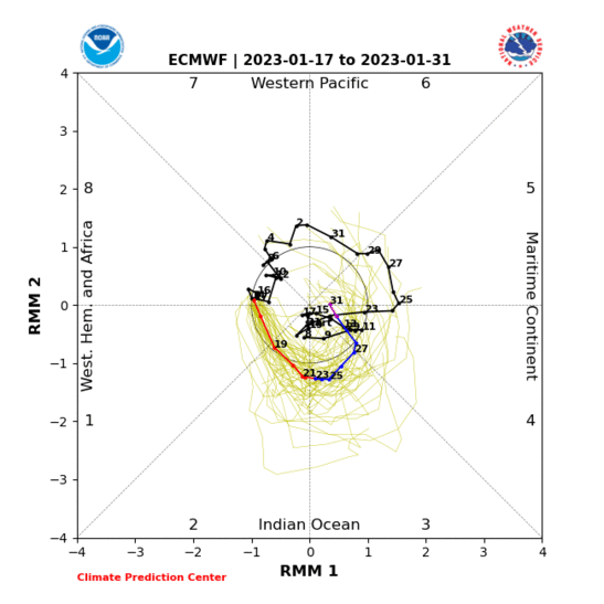
It is possible after the 1st week of January we go through a "thaw" of some kind. The MJO is shown to go into phase 2. Composites of an MJO in phase 2 under La Nina conditions have a SE Ridge placed over the eastern U.S. while the trough stays west. Again, no guarantee this happens yet but if it does it will be after the first week of January.


_________________
_______________________________________________________________________________________________________
CLICK HERE to view NJ Strong Snowstorm Classifications
 Re: Long Range Thread 15.0
Frank do you know how much snow we will get this system for this weekend
frank 638- Senior Enthusiast

- Posts : 2856
Reputation : 37
Join date : 2016-01-01
Age : 41
Location : bronx ny
 Re: Long Range Thread 15.0
frank 638 wrote:Frank do you know how much snow we will get this system for this weekend
Too early to say. May not even snow.
_________________
_______________________________________________________________________________________________________
CLICK HERE to view NJ Strong Snowstorm Classifications
 Re: Long Range Thread 15.0
Come on, Euro! Wouldn't take much of a shift west for us to be singing a different snowtune for this weekend...


SoulSingMG- Senior Enthusiast

- Posts : 2853
Reputation : 74
Join date : 2013-12-11
Location : Long Island City, NY
 Re: Long Range Thread 15.0
the question is, is there any driver to push this further west?
lglickman1- Pro Enthusiast

- Posts : 319
Reputation : 0
Join date : 2013-02-05
Location : New Rochelle, NY
 Re: Long Range Thread 15.0
lglickman1 wrote:the question is, is there any driver to push this further west?
I do not see a mechanism that will lead to an earlier phase, which would push this west. The Atlantic Ridge is also placed far east so I don't think that will be much help to us either. Essentially we need the northern energy to deepen at the right location off the coast so at the surface a low pressure can give us snow.
_________________
_______________________________________________________________________________________________________
CLICK HERE to view NJ Strong Snowstorm Classifications
 Re: Long Range Thread 15.0
Frank_Wx wrote:It is possible after the 1st week of January we go through a "thaw" of some kind. The MJO is shown to go into phase 2. Composites of an MJO in phase 2 under La Nina conditions have a SE Ridge placed over the eastern U.S. while the trough stays west. Again, no guarantee this happens yet but if it does it will be after the first week of January.
True but GEFS show it dying inphase 2 - doesnt neciisarily mean warmth

.png)
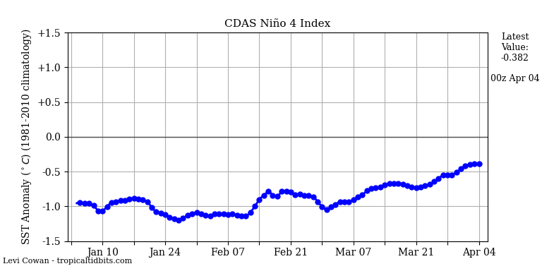
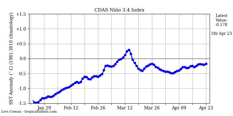
And we have indication that the EPO will be reloading - to what extent remains to be seen but if we have PAC wave breaks buckling the jet and a flare up of convection in the Phase 1/2 regions as JB showed in his video yesterday this may get muted. Remember the low level dense arctic air that is going to blanket the NA continent doesn't go away so fast as it did in the Nino winters of 15-16,16-17. With sown cover that should be down even in teh few inches department by the end of teh first week of Jan will help as well.
Nina states
_________________
Mugs
AKA:King: Snow Weenie
Self Proclaimed
WINTER 2014-15 : 55.12" +.02 for 6 coatings (avg. 35")
WINTER 2015-16 Total - 29.8" (Avg 35")
WINTER 2016-17 : 39.5" so far

amugs- Advanced Forecaster - Mod

- Posts : 15127
Reputation : 213
Join date : 2013-01-07
Age : 54
Location : Hillsdale,NJ
 Re: Long Range Thread 15.0
NAM should just about be in range for Saturday no? Anything interesting (or not interesting) with this run?

crippo84- Posts : 383
Reputation : 20
Join date : 2013-11-07
Age : 40
Location : East Village, NYC
 Re: Long Range Thread 15.0
crippo84 wrote:NAM should just about be in range for Saturday no? Anything interesting (or not interesting) with this run?
Yes


Amounts to about 1-2 inches of snow.
_________________
_______________________________________________________________________________________________________
CLICK HERE to view NJ Strong Snowstorm Classifications
 Re: Long Range Thread 15.0
The GFS does not have anything for Saturday
_________________
_______________________________________________________________________________________________________
CLICK HERE to view NJ Strong Snowstorm Classifications
 Re: Long Range Thread 15.0
CMC is holding on to the bigger storm idea for NEXT week. That’s the only legit threat for all of us.
MattyICE- Advanced Forecaster

- Posts : 249
Reputation : 6
Join date : 2017-11-10
Age : 39
Location : Clifton, NJ (Eastern Passaic County)
 Re: Long Range Thread 15.0
The Canadian model shows a Roidzilla on January 4th, while the GFS is just off-shore. The GFS loses the Pacific ridge. This ridge will be key to the entire set-up. The 4th is just a week away. Hopefully the Ensembles keep showing a signal. As we approach the 1st we would want operational support. This is the time frame rb alluded to. We'll see!!
_________________
_______________________________________________________________________________________________________
CLICK HERE to view NJ Strong Snowstorm Classifications
 Re: Long Range Thread 15.0
Read. (courtesy: @crankywxguy)
http://www.stormhamster.com/e122717.htm
http://www.stormhamster.com/e122717.htm

SoulSingMG- Senior Enthusiast

- Posts : 2853
Reputation : 74
Join date : 2013-12-11
Location : Long Island City, NY
 Re: Long Range Thread 15.0
SoulSingMG wrote:Read. (courtesy: @crankywxguy)
http://www.stormhamster.com/e122717.htm
Tx for posting

weatherwatchermom- Senior Enthusiast

- Posts : 3866
Reputation : 78
Join date : 2014-11-25
Location : Hazlet Township, NJ
 Re: Long Range Thread 15.0
From what I could see on the CMC run, the Jan 4 storm was too far North and West for the coast and South Jersey to get a lot of snow. Do you think this is more likely than not to trend South and East, like the 30-31st storm did? And would that be better for the coast vs the current CMC run?
SnowForest- Posts : 36
Reputation : 4
Join date : 2017-12-19
Location : South NJ
 Re: Long Range Thread 15.0
SnowForest wrote:From what I could see on the CMC run, the Jan 4 storm was too far North and West for the coast and South Jersey to get a lot of snow. Do you think this is more likely than not to trend South and East, like the 30-31st storm did? And would that be better for the coast vs the current CMC run?
The exact track of the low is not something I am paying much attention to. The possibility exists there may not be a storm. First let's make certain a storm will impact the area then we can discuss specifics such as who sees snow and how much. In terms of trends, it can go either way. It will track S&E or out to sea if the ridge on the west coast does not hold together.
_________________
_______________________________________________________________________________________________________
CLICK HERE to view NJ Strong Snowstorm Classifications
 Re: Long Range Thread 15.0
The EURO looks like the NAM for Saturday. A coating to an inch or 2.
_________________
_______________________________________________________________________________________________________
CLICK HERE to view NJ Strong Snowstorm Classifications
 Re: Long Range Thread 15.0
EURO is coming out now for the storm on January 4th. Let's see what it shows, but with the look of this massive PNA ridge, I expect it to show a storm.


_________________
_______________________________________________________________________________________________________
CLICK HERE to view NJ Strong Snowstorm Classifications
 Re: Long Range Thread 15.0
Euro shows the storm but off the coast. Looks like GFS. I am glad the storm is showing up. Plenty of time for it to trend west.
_________________
_______________________________________________________________________________________________________
CLICK HERE to view NJ Strong Snowstorm Classifications
Page 38 of 42 •  1 ... 20 ... 37, 38, 39, 40, 41, 42
Page 38 of 42
Permissions in this forum:
You cannot reply to topics in this forum|
|
|

 Home
Home