
 Search
10/29 - 10/30 Nor'Easter
Page 5 of 16 •  1, 2, 3, 4, 5, 6 ... 10 ... 16
 ![]()
Re: 10/29 - 10/30 Nor'Easter
![]() by Guest Fri Oct 27, 2017 10:13 pm
by Guest Fri Oct 27, 2017 10:13 pm
Guest- Guest
Re: 10/29 - 10/30 Nor'Easter
![]() by jmanley32 Fri Oct 27, 2017 10:19 pm
by jmanley32 Fri Oct 27, 2017 10:19 pm
jmanley32- Senior Enthusiast

- Posts : 20593
Join date : 2013-12-12
Re: 10/29 - 10/30 Nor'Easter
![]() by jmanley32 Fri Oct 27, 2017 10:23 pm
by jmanley32 Fri Oct 27, 2017 10:23 pm

jmanley32- Senior Enthusiast
- Posts : 20593
Reputation : 108
Join date : 2013-12-12
Age : 43
Location : Yonkers, NY
Re: 10/29 - 10/30 Nor'Easter
![]() by jmanley32 Fri Oct 27, 2017 10:24 pm
by jmanley32 Fri Oct 27, 2017 10:24 pm

jmanley32- Senior Enthusiast
- Posts : 20593
Reputation : 108
Join date : 2013-12-12
Age : 43
Location : Yonkers, NY
Re: 10/29 - 10/30 Nor'Easter
![]() by jmanley32 Fri Oct 27, 2017 10:26 pm
by jmanley32 Fri Oct 27, 2017 10:26 pm
jmanley32- Senior Enthusiast
- Posts : 20593
Reputation : 108
Join date : 2013-12-12
Age : 43
Location : Yonkers, NY
Re: 10/29 - 10/30 Nor'Easter
![]() by jmanley32 Fri Oct 27, 2017 10:27 pm
by jmanley32 Fri Oct 27, 2017 10:27 pm
jmanley32- Senior Enthusiast
- Posts : 20593
Reputation : 108
Join date : 2013-12-12
Age : 43
Location : Yonkers, NY
Re: 10/29 - 10/30 Nor'Easter
![]() by jmanley32 Fri Oct 27, 2017 10:29 pm
by jmanley32 Fri Oct 27, 2017 10:29 pm
jmanley32- Senior Enthusiast
- Posts : 20593
Reputation : 108
Join date : 2013-12-12
Age : 43
Location : Yonkers, NY
Re: 10/29 - 10/30 Nor'Easter
![]() by jmanley32 Fri Oct 27, 2017 10:32 pm
by jmanley32 Fri Oct 27, 2017 10:32 pm
jmanley32- Senior Enthusiast
- Posts : 20593
Reputation : 108
Join date : 2013-12-12
Age : 43
Location : Yonkers, NY
Re: 10/29 - 10/30 Nor'Easter
![]() by nutleyblizzard Fri Oct 27, 2017 10:33 pm
by nutleyblizzard Fri Oct 27, 2017 10:33 pm

nutleyblizzard- Senior Enthusiast
- Posts : 1957
Reputation : 41
Join date : 2014-01-30
Age : 58
Location : Nutley, new jersey
Re: 10/29 - 10/30 Nor'Easter
![]() by jmanley32 Fri Oct 27, 2017 10:34 pm
by jmanley32 Fri Oct 27, 2017 10:34 pm
jmanley32- Senior Enthusiast
- Posts : 20593
Reputation : 108
Join date : 2013-12-12
Age : 43
Location : Yonkers, NY
Re: 10/29 - 10/30 Nor'Easter
![]() by Guest Fri Oct 27, 2017 10:37 pm
by Guest Fri Oct 27, 2017 10:37 pm
Guest- Guest
Re: 10/29 - 10/30 Nor'Easter
![]() by jmanley32 Fri Oct 27, 2017 10:37 pm
by jmanley32 Fri Oct 27, 2017 10:37 pm
jmanley32- Senior Enthusiast
- Posts : 20593
Reputation : 108
Join date : 2013-12-12
Age : 43
Location : Yonkers, NY
Re: 10/29 - 10/30 Nor'Easter
![]() by jmanley32 Fri Oct 27, 2017 10:39 pm
by jmanley32 Fri Oct 27, 2017 10:39 pm
jmanley32- Senior Enthusiast
- Posts : 20593
Reputation : 108
Join date : 2013-12-12
Age : 43
Location : Yonkers, NY
Re: 10/29 - 10/30 Nor'Easter
![]() by jmanley32 Fri Oct 27, 2017 10:41 pm
by jmanley32 Fri Oct 27, 2017 10:41 pm
jmanley32- Senior Enthusiast
- Posts : 20593
Reputation : 108
Join date : 2013-12-12
Age : 43
Location : Yonkers, NY
Re: 10/29 - 10/30 Nor'Easter
![]() by jmanley32 Fri Oct 27, 2017 10:59 pm
by jmanley32 Fri Oct 27, 2017 10:59 pm
jmanley32- Senior Enthusiast
- Posts : 20593
Reputation : 108
Join date : 2013-12-12
Age : 43
Location : Yonkers, NY
Re: 10/29 - 10/30 Nor'Easter
![]() by amugs Fri Oct 27, 2017 11:16 pm
by amugs Fri Oct 27, 2017 11:16 pm
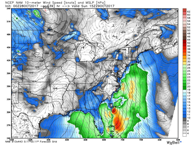
This is going to be a bad storm with jet streak over head I showed a few maps above

_________________
Mugs
AKA:King: Snow Weenie
Self Proclaimed
WINTER 2014-15 : 55.12" +.02 for 6 coatings (avg. 35")
WINTER 2015-16 Total - 29.8" (Avg 35")
WINTER 2016-17 : 39.5" so far

amugs- Advanced Forecaster - Mod

- Posts : 15095
Reputation : 213
Join date : 2013-01-07
Age : 54
Location : Hillsdale,NJ
Re: 10/29 - 10/30 Nor'Easter
![]() by jmanley32 Fri Oct 27, 2017 11:18 pm
by jmanley32 Fri Oct 27, 2017 11:18 pm
Mugs you think here in NYC area we could see gusts over 60mph? Even maybe on Sunday night? Or only on the back end. I read on a board that the NAM brought all 3 pieces together not just one part. Hence the much stronger storm.amugs wrote:Thunder model package from Ventricle which called Irma, Maria and Haavy
This is going to be a bad storm with jet streak over head I showed a few maps above
jmanley32- Senior Enthusiast
- Posts : 20593
Reputation : 108
Join date : 2013-12-12
Age : 43
Location : Yonkers, NY
Re: 10/29 - 10/30 Nor'Easter
![]() by amugs Fri Oct 27, 2017 11:25 pm
by amugs Fri Oct 27, 2017 11:25 pm
_________________
Mugs
AKA:King: Snow Weenie
Self Proclaimed
WINTER 2014-15 : 55.12" +.02 for 6 coatings (avg. 35")
WINTER 2015-16 Total - 29.8" (Avg 35")
WINTER 2016-17 : 39.5" so far
amugs- Advanced Forecaster - Mod
- Posts : 15095
Reputation : 213
Join date : 2013-01-07
Age : 54
Location : Hillsdale,NJ
Re: 10/29 - 10/30 Nor'Easter
![]() by jmanley32 Fri Oct 27, 2017 11:58 pm
by jmanley32 Fri Oct 27, 2017 11:58 pm
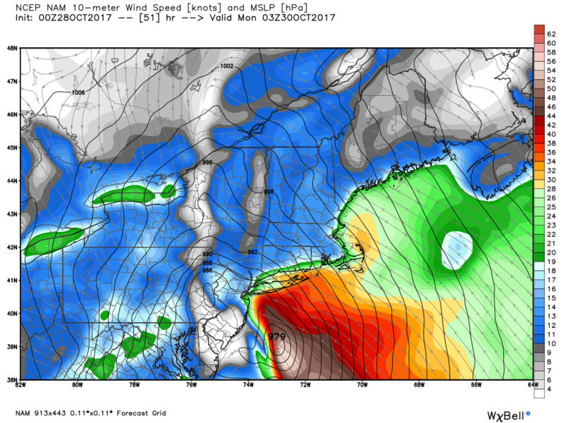
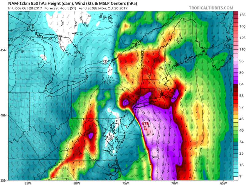
gotcha, gfs looks similar to 18z but stronger, still not putting out winds like other models.amugs wrote:If we get then full phase that is being projected the system has to come wst as depicted in the EPS and EURO which seem to be locked in on this systems path. The jet streak is potent and ifbthisnfullmphase happens over the Carolinas then this could rival the 92 Noreaster and be Sandyesque with its winds. So yes we could see 60 mph gusts if this comes to fruition.the tropical entity is again the key component.
jmanley32- Senior Enthusiast
- Posts : 20593
Reputation : 108
Join date : 2013-12-12
Age : 43
Location : Yonkers, NY
Re: 10/29 - 10/30 Nor'Easter
![]() by jmanley32 Sat Oct 28, 2017 12:11 am
by jmanley32 Sat Oct 28, 2017 12:11 am
jmanley32- Senior Enthusiast
- Posts : 20593
Reputation : 108
Join date : 2013-12-12
Age : 43
Location : Yonkers, NY
jmanley32- Senior Enthusiast
- Posts : 20593
Reputation : 108
Join date : 2013-12-12
Age : 43
Location : Yonkers, NY
Re: 10/29 - 10/30 Nor'Easter
![]() by Math23x7 Sat Oct 28, 2017 1:48 am
by Math23x7 Sat Oct 28, 2017 1:48 am
Math23x7- Wx Statistician Guru

- Posts : 2380
Reputation : 68
Join date : 2013-01-08
Re: 10/29 - 10/30 Nor'Easter
![]() by sroc4 Sat Oct 28, 2017 6:13 am
by sroc4 Sat Oct 28, 2017 6:13 am
A highly amplified upper flow will feature a full latitude
trough east of the Mississippi River. Model consensus is in good
agreement with energy at the base of this upper trough closing
off an upper low over the Tennessee Valley Sunday morning, then
lifting NE toward the Mid Atlantic states as the trough becomes
negatively tiled. A frontal wave forms along the Mid Atlantic
coast Sunday, lifting N-NW and into the NYC area Sunday
evening.
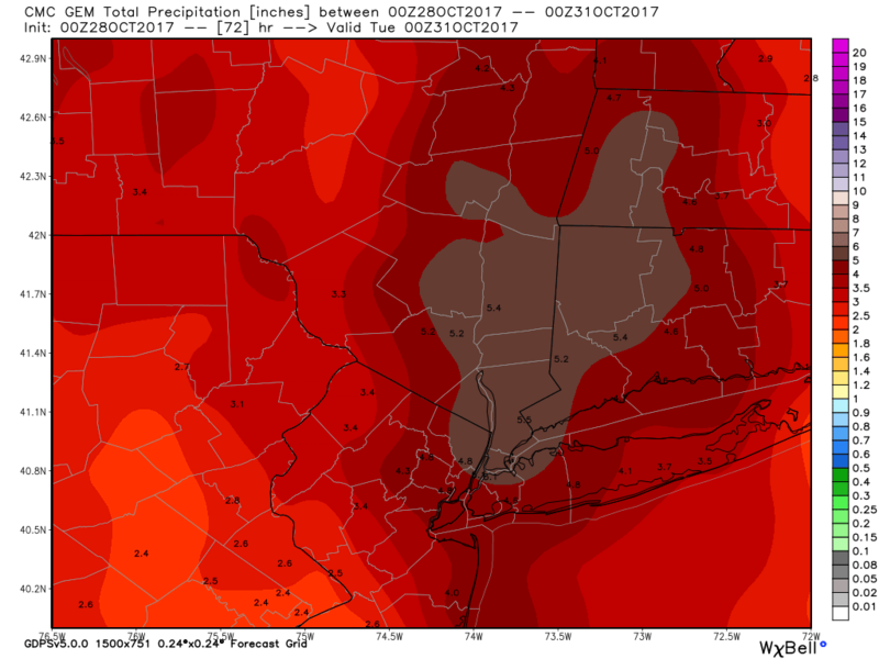
This system will have deep tropical moisture available with its
origins from the Western Caribbean and eastern Gulf of Mexico.
Additionally, interaction with Potential Tropical Cyclone 18,
will tap in on additional moisture and energy from the tropics.
This will allow for a warm conveyor belt to set up along and
just off the east coast with bands of heavy rain showers and
embedded convection to work into the area Sunday into Sunday
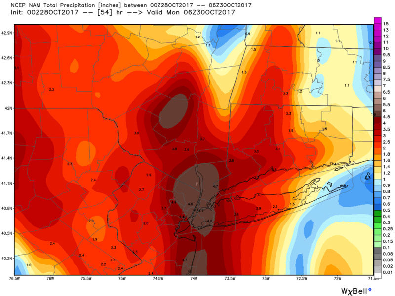
night. Widespread rainfall amounts of 2 to 3 inches are likely,
with localized amounts up to 6 inches. While the area has been
dry over the last couple of months, recent heavy rains this week
and the likelihood of additional significant rainfall has
necessitated the issuance of a flash flood watch. Any flooding
will likely be of the urban/poor drainage variety as well as
flashier small streams.
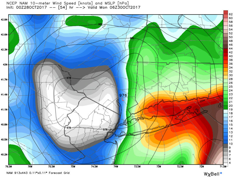
(Wind discussion for the Jman)
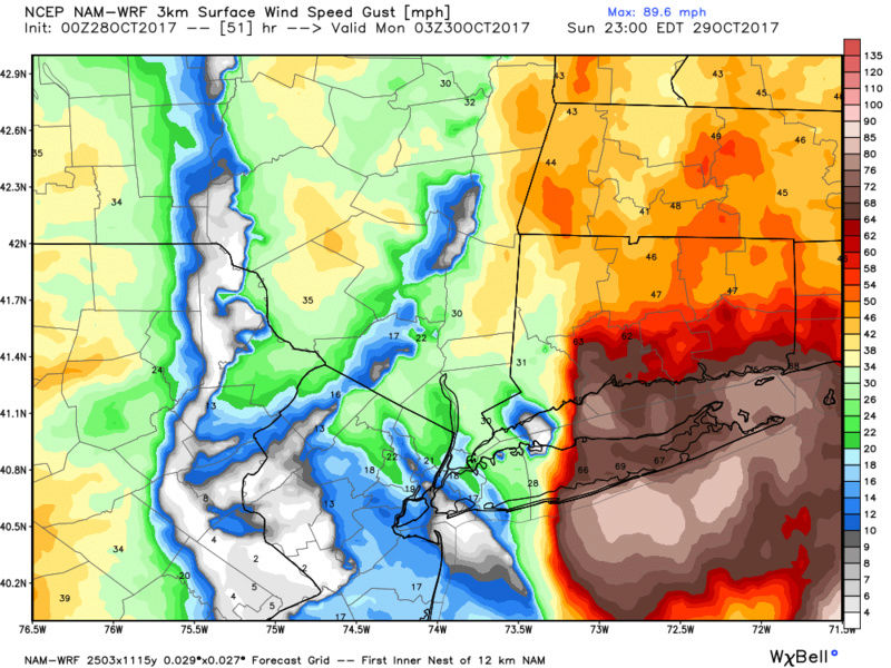
The next potential hazard is for high winds Sunday night into
Monday. The aforementioned southerly LLJ has the potential to
bring high winds up to 60 mph to eastern LI and southern CT
Sunday night. Model consensus is taking the low track just west
of these areas. Any subsequent shift (west/east) would alter
the location of this axis of high winds. Model soundings with
the close proximity of warm near shore waters support sufficient
mixing for this high wind potential. Lapse rates at some of the
coastal upper air soundings exceed moist adiabatic lapse rates,
which is a strong signal for mixing some of these high winds to
the surface. As such, a high wind watch is in effect.
On the backside of the low Monday, gusty west winds will likely
meet wind advisory criteria, perhaps even high wind warning
criteria. Confidence is too low for a watch at this time.
Conditions dry out Monday morning with temperatures returning
to seasonable levels on the backside of the system.
_________________
"In weather and in life, there's no winning and losing; there's only winning and learning."
WINTER 2012/2013 TOTALS 43.65"WINTER 2017/2018 TOTALS 62.85" WINTER 2022/2023 TOTALS 4.9"
WINTER 2013/2014 TOTALS 64.85"WINTER 2018/2019 TOTALS 14.25" WINTER 2023/2024 TOTALS 13.1"
WINTER 2014/2015 TOTALS 71.20"WINTER 2019/2020 TOTALS 6.35"
WINTER 2015/2016 TOTALS 35.00"WINTER 2020/2021 TOTALS 37.75"
WINTER 2016/2017 TOTALS 42.25"WINTER 2021/2022 TOTALS 31.65"

sroc4- Admin

- Posts : 8389
Reputation : 302
Join date : 2013-01-07
Location : Wading River, LI
Re: 10/29 - 10/30 Nor'Easter
![]() by sabamfa Sat Oct 28, 2017 7:00 am
by sabamfa Sat Oct 28, 2017 7:00 am
sabamfa- Pro Enthusiast

- Posts : 246
Reputation : 2
Join date : 2013-11-05
Age : 38
Location : Wayne, NJ
Re: 10/29 - 10/30 Nor'Easter
![]() by jmanley32 Sat Oct 28, 2017 7:20 am
by jmanley32 Sat Oct 28, 2017 7:20 am
Darn no sig wind here I guess per that but that's a lot of rain. I guess I'll have go to li lol. I see it would have to be a bit more west but not by much to bring the hww into the area. Not impossible since New Haven county is in it that's only 80 miles or less to my east.sroc4 wrote:Here is this mornings discussion from Upton. Sums things up nicely.
A highly amplified upper flow will feature a full latitude
trough east of the Mississippi River. Model consensus is in good
agreement with energy at the base of this upper trough closing
off an upper low over the Tennessee Valley Sunday morning, then
lifting NE toward the Mid Atlantic states as the trough becomes
negatively tiled. A frontal wave forms along the Mid Atlantic
coast Sunday, lifting N-NW and into the NYC area Sunday
evening.
This system will have deep tropical moisture available with its
origins from the Western Caribbean and eastern Gulf of Mexico.
Additionally, interaction with Potential Tropical Cyclone 18,
will tap in on additional moisture and energy from the tropics.
This will allow for a warm conveyor belt to set up along and
just off the east coast with bands of heavy rain showers and
embedded convection to work into the area Sunday into Sunday
night. Widespread rainfall amounts of 2 to 3 inches are likely,
with localized amounts up to 6 inches. While the area has been
dry over the last couple of months, recent heavy rains this week
and the likelihood of additional significant rainfall has
necessitated the issuance of a flash flood watch. Any flooding
will likely be of the urban/poor drainage variety as well as
flashier small streams.
(Wind discussion for the Jman)
The next potential hazard is for high winds Sunday night into
Monday. The aforementioned southerly LLJ has the potential to
bring high winds up to 60 mph to eastern LI and southern CT
Sunday night. Model consensus is taking the low track just west
of these areas. Any subsequent shift (west/east) would alter
the location of this axis of high winds. Model soundings with
the close proximity of warm near shore waters support sufficient
mixing for this high wind potential. Lapse rates at some of the
coastal upper air soundings exceed moist adiabatic lapse rates,
which is a strong signal for mixing some of these high winds to
the surface. As such, a high wind watch is in effect.
On the backside of the low Monday, gusty west winds will likely
meet wind advisory criteria, perhaps even high wind warning
criteria. Confidence is too low for a watch at this time.
Conditions dry out Monday morning with temperatures returning
to seasonable levels on the backside of the system.
jmanley32- Senior Enthusiast
- Posts : 20593
Reputation : 108
Join date : 2013-12-12
Age : 43
Location : Yonkers, NY
Re: 10/29 - 10/30 Nor'Easter
![]() by jmanley32 Sat Oct 28, 2017 7:32 am
by jmanley32 Sat Oct 28, 2017 7:32 am
Last edited by jmanley32 on Sat Oct 28, 2017 7:37 am; edited 1 time in total
jmanley32- Senior Enthusiast
- Posts : 20593
Reputation : 108
Join date : 2013-12-12
Age : 43
Location : Yonkers, NY
Re: 10/29 - 10/30 Nor'Easter
![]() by docstox12 Sat Oct 28, 2017 7:37 am
by docstox12 Sat Oct 28, 2017 7:37 am

docstox12- Wx Statistician Guru
- Posts : 8557
Reputation : 222
Join date : 2013-01-07
Age : 73
Location : Monroe NY
Page 5 of 16 • 1, 2, 3, 4, 5, 6 ... 10 ... 16 ![]()
|
|
|