January 4th Mothrazilla: Final Call & Observations
+63
Fededle22
NettWx
yorkseer
SENJsnowman
crippo84
abayoumi21
energy1276
SkiSeadooJoe
sroc4
essexcountypete
Mathgod55
track17
dkodgis
oldtimer
clownloach
larryrock72
heehaw453
Vinnydula
brownie
Smarnold
MattyICE
Dunnzoo
algae888
bloc1357
mmanisca
docstox12
goalscore
Roger92
Smitty623
NjWeatherGuy
2004blackwrx
Taffy
SoulSingMG
Dtone
Math23x7
CPcantmeasuresnow
dsix85
emokid51783
Snow88
Joe Snow
Quietace
skinsfan1177
mwilli5783
Nyi1058
lglickman1
jmanley32
nutleyblizzard
aiannone
weatherwatchermom
Sanchize06
jimv45
rb924119
Artechmetals
GreyBeard
amugs
billg315
RJB8525
Scullybutcher
Carter bk
hyde345
frank 638
mikeypizano
Frank_Wx
67 posters
Page 1 of 32
Page 1 of 32 • 1, 2, 3 ... 16 ... 32 
 January 4th Mothrazilla: Final Call & Observations
I mentioned this is the other thread but this is definitely one of the most challenging storms I've ever had to forecast. All week we've been pointing out how surface is not matching the upper air pattern. We were expecting bigger outcomes but the Global models kept showing a minor to moderate event. Since early this morning - the NAM - and some other models - have dramatically increased QPF. These mesoscale models tend to perform better with system where a lot of convection is jet dynamics are involved. The NAM closed off H5 this morning and even the Global models have come around to this idea today. However, they're still not showing the type of precip the NAM is. The latest GFS even throws more uncertainty into the wrench showing MIX for central LI and RAIN for eastern LI. This goes to show the west trend we've been seeing the last several days is real.
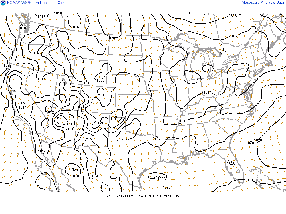
The 500mb trough is going negative and you'll notice isobars associated with our storm are pointing more north than northeast. This is one piece of evidence the storm will track closer to the coast than where some Globals show.

The 850mb low (shown here) and the 700mb low will be key to follow. We want this features to stack over the 500mb low. The 500mb low is likely to close off early tomorrow morning near the BM. But some models put the 850/700mb low EAST of the 500mb low which keeps the heaviest banding / forcing confined to LI or off the coast entirely. Obviously higher snowfall rates will increase accumulation amounts.

Much of the 500mb PVA will stay over coastal NJ and Long Island. NYC may even get into some of it at times. The Hi-Res NAM does push it more west. This is where the forecast becomes most challenging. Where does the best banding set-up?

Precipitation is ahead of schedule. Early in means early out. I am thinking snow could break out, especially for southern areas, by 1am-3am then taper off between 3-5pm on Thursday.
Here is my final call snow map.
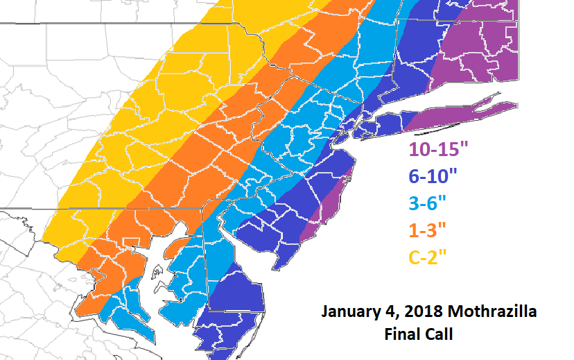
Based off the aforementioned observations this will be my final call. I will not adjust after the 00z runs tonight. Note: it is possible there could be shifts with the cut-off zones EITHER DIRECTION by as much as 25 to maybe even 50 miles. That's how much uncertainty there is at the moment with where banding sets up and how heavy the precip rates will be. It will be a fun one to track.
Mothrazilla 2K18!

The 500mb trough is going negative and you'll notice isobars associated with our storm are pointing more north than northeast. This is one piece of evidence the storm will track closer to the coast than where some Globals show.

The 850mb low (shown here) and the 700mb low will be key to follow. We want this features to stack over the 500mb low. The 500mb low is likely to close off early tomorrow morning near the BM. But some models put the 850/700mb low EAST of the 500mb low which keeps the heaviest banding / forcing confined to LI or off the coast entirely. Obviously higher snowfall rates will increase accumulation amounts.
Much of the 500mb PVA will stay over coastal NJ and Long Island. NYC may even get into some of it at times. The Hi-Res NAM does push it more west. This is where the forecast becomes most challenging. Where does the best banding set-up?

Precipitation is ahead of schedule. Early in means early out. I am thinking snow could break out, especially for southern areas, by 1am-3am then taper off between 3-5pm on Thursday.
Here is my final call snow map.

Based off the aforementioned observations this will be my final call. I will not adjust after the 00z runs tonight. Note: it is possible there could be shifts with the cut-off zones EITHER DIRECTION by as much as 25 to maybe even 50 miles. That's how much uncertainty there is at the moment with where banding sets up and how heavy the precip rates will be. It will be a fun one to track.
Mothrazilla 2K18!
_________________
_______________________________________________________________________________________________________
CLICK HERE to view NJ Strong Snowstorm Classifications
 Re: January 4th Mothrazilla: Final Call & Observations
Still don’t like it frank, can you make me 12 inch plus?

mikeypizano- Pro Enthusiast

- Posts : 1118
Reputation : 66
Join date : 2017-01-05
Age : 35
Location : Wilkes-Barre/Scranton, PA
 Re: January 4th Mothrazilla: Final Call & Observations
frank thank you for ur post and maps you put up even almost all weather stations are saying we will see 6 plus for the city and a foot for east of longisland
frank 638- Senior Enthusiast

- Posts : 2879
Reputation : 37
Join date : 2016-01-01
Age : 41
Location : bronx ny
 Re: January 4th Mothrazilla: Final Call & Observations
That map makes a lot of sense Frank. Good call. This one has been tough.

hyde345- Pro Enthusiast

- Posts : 1083
Reputation : 48
Join date : 2013-01-08
Location : Hyde Park, NY
 Re: January 4th Mothrazilla: Final Call & Observations
Like it frank but i really think the 10 to 15 should be from city east and is that with ratios
Carter bk- Posts : 73
Reputation : 5
Join date : 2017-12-07
 Re: January 4th Mothrazilla: Final Call & Observations
Put a ruler down on the 10-15" line starting jersey shore into eastern LI and Ct. it takes a right over LI then back left enough in Ct just enough to miss me being in it by 2 miles. Done on purpose by our leader
Guest- Guest
 Re: January 4th Mothrazilla: Final Call & Observations
Love the map. Puts me in the 10 - 15. I hope it’s busts high but it will be moving at a good pace.
Scullybutcher- Pro Enthusiast

- Posts : 544
Reputation : 16
Join date : 2013-02-06
Location : North Smithtown, western Suffolk county, long island
 Re: January 4th Mothrazilla: Final Call & Observations
You mean busts low scully. Frank and Scott have a habit of doing this. Lol
Guest- Guest
 Re: January 4th Mothrazilla: Final Call & Observations
even lonnie is saying manhattan will get 6 inches then brooklyn queens and the bronx will get 6 to 12 inches
frank 638- Senior Enthusiast

- Posts : 2879
Reputation : 37
Join date : 2016-01-01
Age : 41
Location : bronx ny
 Re: January 4th Mothrazilla: Final Call & Observations
ohhh i'm at the line split between 1-3/3-6 lol hopefully i can squeak out 3"

RJB8525- Senior Enthusiast

- Posts : 1994
Reputation : 28
Join date : 2013-02-06
Age : 38
Location : Hackettstown, NJ
 Re: January 4th Mothrazilla: Final Call & Observations
Carter bk wrote:Like it frank but i really think the 10 to 15 should be from city east and is that with ratios
Yes with ratios.
syosnow94 wrote:Put a ruler down on the 10-15" line starting jersey shore into eastern LI and Ct. it takes a right over LI then back left enough in Ct just enough to miss me being in it by 2 miles. Done on purpose by our leader
 not on purpose. But I do mention there could be 25 to 50 mile shifts in either direction. So you can consider yourself more in an 8-12 zone with 12+ possible. It's how you interpret the map
 _________________
_______________________________________________________________________________________________________
CLICK HERE to view NJ Strong Snowstorm Classifications
 Re: January 4th Mothrazilla: Final Call & Observations
I was hoping it was in purpose. It's funny. I'm going 10-18" from NYC east
Guest- Guest
 Re: January 4th Mothrazilla: Final Call & Observations
Solid map. I do think most in the 3-6 zone end up at or close to the 6” with a sharp drop off to 3 near the border wit the 1-3 zone.

billg315- Advanced Forecaster - Mod

- Posts : 4556
Reputation : 185
Join date : 2015-01-24
Age : 50
Location : Flemington, NJ
 Re: January 4th Mothrazilla: Final Call & Observations
Excellent work. .
As Frank pointed out a w5 mile shift west with the trends so far would bring the entire NYC metro area in the Secs to mecs category. I think the HI RES NAM will verify and put us about 10-15 more miles west looking at convection and latest radar.
As Frank pointed out a w5 mile shift west with the trends so far would bring the entire NYC metro area in the Secs to mecs category. I think the HI RES NAM will verify and put us about 10-15 more miles west looking at convection and latest radar.
_________________
Mugs
AKA:King: Snow Weenie
Self Proclaimed
WINTER 2014-15 : 55.12" +.02 for 6 coatings (avg. 35")
WINTER 2015-16 Total - 29.8" (Avg 35")
WINTER 2016-17 : 39.5" so far

amugs- Advanced Forecaster - Mod

- Posts : 15148
Reputation : 213
Join date : 2013-01-07
Age : 54
Location : Hillsdale,NJ
 Re: January 4th Mothrazilla: Final Call & Observations
Like the map Frank, but a quick question. With forecast winds both during and after the storm, we could theoretically be looking at blizzard conditions all the way through the weekend,no?
GreyBeard- Senior Enthusiast

- Posts : 731
Reputation : 34
Join date : 2014-02-12
Location : Boca Raton, Fl.
 Re: January 4th Mothrazilla: Final Call & Observations
Hi Frank we are about 11 miles apart are we in the 3 to 6 range ?
Artechmetals- Pro Enthusiast

- Posts : 571
Reputation : 3
Join date : 2014-01-01
Age : 57
Location : Wayne , NJ
 Re: January 4th Mothrazilla: Final Call & Observations
GreyBeard wrote:Like the map Frank, but a quick question. With forecast winds both during and after the storm, we could theoretically be looking at blizzard conditions all the way through the weekend,no?
Yes, great point. Blowing and drifting snow. Extreme cold and high winds behind this storm. The aftermath will not be pretty.
Artechmetals wrote:Hi Frank we are about 11 miles apart are we in the 3 to 6 range ?
Yes but on the high end
_________________
_______________________________________________________________________________________________________
CLICK HERE to view NJ Strong Snowstorm Classifications
 Re: January 4th Mothrazilla: Final Call & Observations
From Super storm Deep Thunder wow qpf


_________________
Mugs
AKA:King: Snow Weenie
Self Proclaimed
WINTER 2014-15 : 55.12" +.02 for 6 coatings (avg. 35")
WINTER 2015-16 Total - 29.8" (Avg 35")
WINTER 2016-17 : 39.5" so far

amugs- Advanced Forecaster - Mod

- Posts : 15148
Reputation : 213
Join date : 2013-01-07
Age : 54
Location : Hillsdale,NJ
 Re: January 4th Mothrazilla: Final Call & Observations
Frank_Wx wrote:Carter bk wrote:Like it frank but i really think the 10 to 15 should be from city east and is that with ratios
Yes with ratios.syosnow94 wrote:Put a ruler down on the 10-15" line starting jersey shore into eastern LI and Ct. it takes a right over LI then back left enough in Ct just enough to miss me being in it by 2 miles. Done on purpose by our leader
not on purpose. But I do mention there could be 25 to 50 mile shifts in either direction. So you can consider yourself more in an 8-12 zone with 12+ possible. It's how you interpret the map
Taking the politically correct approach so as not to upset the tribe.....I respect it, I respect it ahahahaha jk, buddy, I like it! Personally, I think you can bank on that shift west versus east, and increase totals across EPa, but seeing as though I have not made a map myself, I will not nitpick lol I know you put a lot of work in with this, and for once, do not envy being in your position, as I know the despair of trying to decide on what to do all too well aha. This has been, and continues to be, a nightmare for all of us. That said, I think it's important that we recognize the fact that you are taking a stand and putting your thoughts out there for judgement, rather than broadbrushing. Bravo, and can't wait to see how this verifies!!! Great work!!
rb924119- Meteorologist

- Posts : 7102
Reputation : 195
Join date : 2013-02-06
Age : 32
Location : Greentown, Pa
 Re: January 4th Mothrazilla: Final Call & Observations
I was looking at the water vapor loop and radar and man it looks impressive.

hyde345- Pro Enthusiast

- Posts : 1083
Reputation : 48
Join date : 2013-01-08
Location : Hyde Park, NY
 Re: January 4th Mothrazilla: Final Call & Observations
rb924119 wrote:Frank_Wx wrote:Carter bk wrote:Like it frank but i really think the 10 to 15 should be from city east and is that with ratios
Yes with ratios.syosnow94 wrote:Put a ruler down on the 10-15" line starting jersey shore into eastern LI and Ct. it takes a right over LI then back left enough in Ct just enough to miss me being in it by 2 miles. Done on purpose by our leader
not on purpose. But I do mention there could be 25 to 50 mile shifts in either direction. So you can consider yourself more in an 8-12 zone with 12+ possible. It's how you interpret the map
Taking the politically correct approach so as not to upset the tribe.....I respect it, I respect it ahahahaha jk, buddy, I like it! Personally, I think you can bank on that shift west versus east, and increase totals across EPa, but seeing as though I have not made a map myself, I will not nitpick lol I know you put a lot of work in with this, and for once, do not envy being in your position, as I know the despair of trying to decide on what to do all too well aha. This has been, and continues to be, a nightmare for all of us. That said, I think it's important that we recognize the fact that you are taking a stand and putting your thoughts out there for judgement, rather than broadbrushing. Bravo, and can't wait to see how this verifies!!! Great work!!
If the HRRR has it's way all western regions will see a few flakes. With ratios you may crack 1 inch.
- Attachments
_________________
_______________________________________________________________________________________________________
CLICK HERE to view NJ Strong Snowstorm Classifications
 Re: January 4th Mothrazilla: Final Call & Observations
Looking at present WV imagery it looks to me like our establishing low-level circulation is on a "B" line directly WEST of Hatteras. If that trajectory maintains, my god......you'd have your best banding set up as far west as EPa.
rb924119- Meteorologist

- Posts : 7102
Reputation : 195
Join date : 2013-02-06
Age : 32
Location : Greentown, Pa
 Re: January 4th Mothrazilla: Final Call & Observations
Frank_Wx wrote:rb924119 wrote:Frank_Wx wrote:Carter bk wrote:Like it frank but i really think the 10 to 15 should be from city east and is that with ratios
Yes with ratios.syosnow94 wrote:Put a ruler down on the 10-15" line starting jersey shore into eastern LI and Ct. it takes a right over LI then back left enough in Ct just enough to miss me being in it by 2 miles. Done on purpose by our leader
not on purpose. But I do mention there could be 25 to 50 mile shifts in either direction. So you can consider yourself more in an 8-12 zone with 12+ possible. It's how you interpret the map
Taking the politically correct approach so as not to upset the tribe.....I respect it, I respect it ahahahaha jk, buddy, I like it! Personally, I think you can bank on that shift west versus east, and increase totals across EPa, but seeing as though I have not made a map myself, I will not nitpick lol I know you put a lot of work in with this, and for once, do not envy being in your position, as I know the despair of trying to decide on what to do all too well aha. This has been, and continues to be, a nightmare for all of us. That said, I think it's important that we recognize the fact that you are taking a stand and putting your thoughts out there for judgement, rather than broadbrushing. Bravo, and can't wait to see how this verifies!!! Great work!!
If the HRRR has it's way all western regions will see a few flakes. With ratios you may crack 1 inch.
Lucky for me I actually despise that model. Every single time I look at it/use it I get burned. So I don't even bother, and therefore that solution doesn't exist ahaha
rb924119- Meteorologist

- Posts : 7102
Reputation : 195
Join date : 2013-02-06
Age : 32
Location : Greentown, Pa
 Re: January 4th Mothrazilla: Final Call & Observations
syosnow94 wrote:You mean busts low scully. Frank and Scott have a habit of doing this. Lol
Yes. I want the most snow for everyone possible. It’s like turning the ac up or down always confusion.

Scullybutcher- Pro Enthusiast

- Posts : 544
Reputation : 16
Join date : 2013-02-06
Location : North Smithtown, western Suffolk county, long island
Page 1 of 32 • 1, 2, 3 ... 16 ... 32 
Page 1 of 32
Permissions in this forum:
You cannot reply to topics in this forum
 Home
Home
