
 Search
March 7th-8th 2018 Storm Potential
Page 1 of 19 • 1, 2, 3 ... 10 ... 19 ![]()

March 7th-8th 2018 Storm Potential
![]() by sroc4 Sun Mar 04, 2018 9:34 am
by sroc4 Sun Mar 04, 2018 9:34 am


Lets take a look at a few things. I will try and keep it as simplified as possible. To do so we will look at the surface and the 850mb(5000ft) set up and compare the prev and the upcoming.
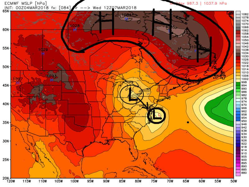
Simply stated the air mass or source regions for the air that will be pulled into the centers of our low pressure vortex at the various levels of the atmosphere will be vastly different. In both set ups we will have a surface low in similar positions, and a closed 850mb low, 700mb low, and 500mb low in similar positions just south of LI but the atmosphere surrounding them is what will be diff. Look at the set up for the surface and 850mb levels. Images will have the March 2nd set up first followed by the 7th/8th

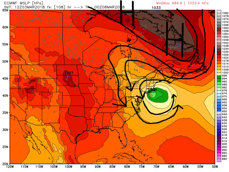

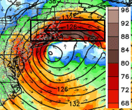
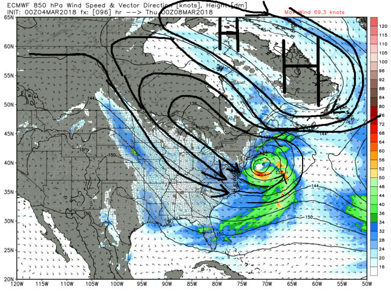
So as you can clearly see that with this current set up the source region is much more favorable for cold air. You can see by the close up shot of 850mb I showed above the winds were screaming into the coast in the mid levels right off the ocean just absolutely flooding the air mass with warm ocean air. While it wont be a direct arctic air mass that we are working with we will have a much colder source region from which to draw from given the position and strength of the surrounding features.
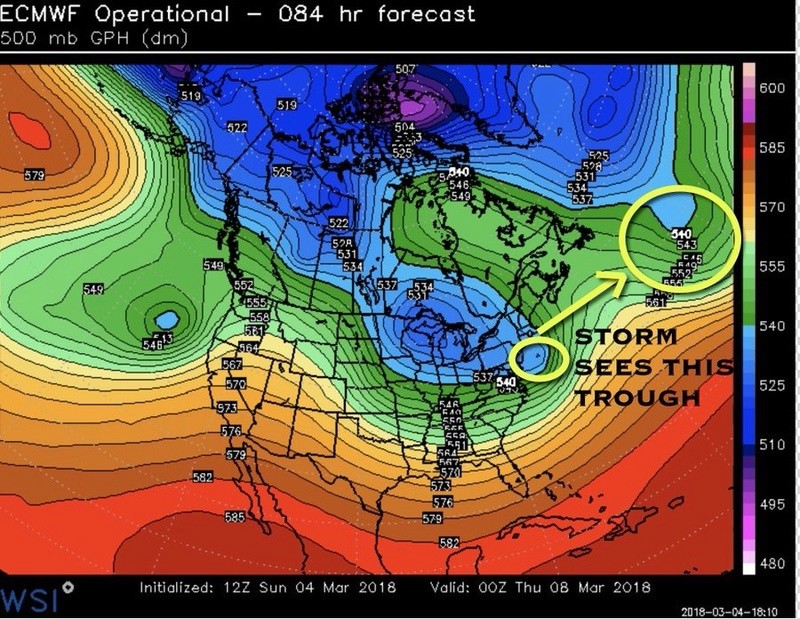
Now lets shift gears to 500mb set up for the up coming system only. Below is the evolution using the euro but GFS and other globals are pretty similar with the general progression of the pattern.
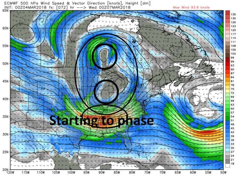
I have outlined the two 500mb feautures that will come together to generate our storm. There are two import features to look at ahead of the storm. First notice the HP in the top right and the ULL in the bottom right of all the images below. Notice that they do not mov at all. This is our block, plain and simple and is critical to all of this. Without it we wouldnt be having this discussion. Second as we head into Mon/Tues (2nd and 3rd image below) we get a reinforcing shot of cold air in the upper levels. Again not straight up arctic, but colder than what we had pre March 2nd storm without question. As we head into the Early Wed time frame notice the two upper level pieces of energy begin to interact and phase.


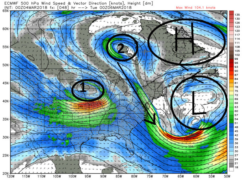
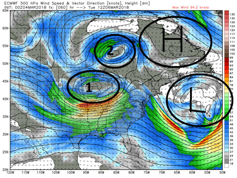
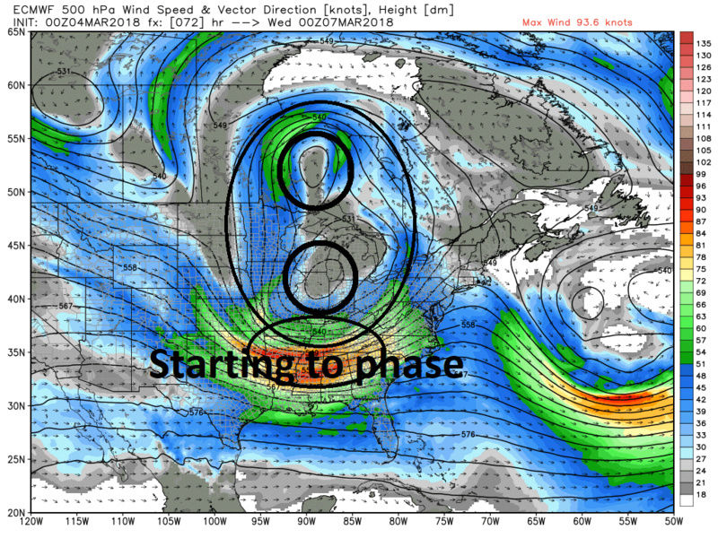
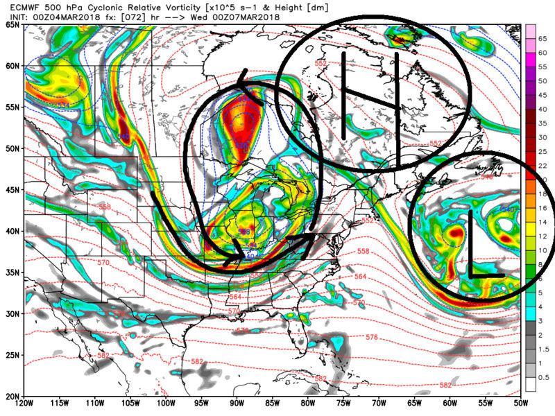
To reiterate without the block this storm cuts and we get another rant from Jimmy about how awful this winter is. BUT because there is a block the surface low again trys to cut into the Ohio valley and Nwestern NY, just like the March 2nd, and is forced to transfer to the coast as it runs into the block (the banana HP(because it looks like a banana) to the north). Its the shape and position of the HP that is why this system has more cold air to work with in along the boundary and low levels.

This general set up is pretty much uniform throughout all modeling. However, there are still minor details to be worked out which is what shapes the IMBY results. Where, when, or if the 500mb low closes off; where is the exact track of the surface low will all be important. Again the mid level temps should not be an issue even for the coast, unless the track is over LI or west. The boundary layer cold although much improved over the last system is still a question mark for the coastal plain. That said a positive for this storm and boundary layer temps is unlike the prev storm where we got started early in the day and got cranking at the peak of the daylight hrs, this system looks to get started mid-day and peak when sun angle shouldn't play as big or any roll if the heaviest comes in at night. This is an esp important point for the coastal plain. Lets see what our trends hold over the next 24hrs.
We Track!!!!!

Last edited by sroc4 on Sun Mar 04, 2018 9:44 am; edited 4 times in total
_________________
"In weather and in life, there's no winning and losing; there's only winning and learning."
WINTER 2012/2013 TOTALS 43.65"WINTER 2017/2018 TOTALS 62.85" WINTER 2022/2023 TOTALS 4.9"
WINTER 2013/2014 TOTALS 64.85"WINTER 2018/2019 TOTALS 14.25" WINTER 2023/2024 TOTALS 13.1"
WINTER 2014/2015 TOTALS 71.20"WINTER 2019/2020 TOTALS 6.35"
WINTER 2015/2016 TOTALS 35.00"WINTER 2020/2021 TOTALS 37.75"
WINTER 2016/2017 TOTALS 42.25"WINTER 2021/2022 TOTALS 31.65"

sroc4- Admin

- Posts : 8389
Reputation : 302
Join date : 2013-01-07
Location : Wading River, LI
Re: March 7th-8th 2018 Storm Potential
![]() by sroc4 Sun Mar 04, 2018 9:38 am
by sroc4 Sun Mar 04, 2018 9:38 am
_________________
"In weather and in life, there's no winning and losing; there's only winning and learning."
WINTER 2012/2013 TOTALS 43.65"WINTER 2017/2018 TOTALS 62.85" WINTER 2022/2023 TOTALS 4.9"
WINTER 2013/2014 TOTALS 64.85"WINTER 2018/2019 TOTALS 14.25" WINTER 2023/2024 TOTALS 13.1"
WINTER 2014/2015 TOTALS 71.20"WINTER 2019/2020 TOTALS 6.35"
WINTER 2015/2016 TOTALS 35.00"WINTER 2020/2021 TOTALS 37.75"
WINTER 2016/2017 TOTALS 42.25"WINTER 2021/2022 TOTALS 31.65"
sroc4- Admin
- Posts : 8389
Reputation : 302
Join date : 2013-01-07
Location : Wading River, LI
Re: March 7th-8th 2018 Storm Potential
![]() by amugs Sun Mar 04, 2018 10:09 am
by amugs Sun Mar 04, 2018 10:09 am
Billings post should be moved over here as well for his points.
This needs to be more evening and nightfall, timing is crucial IMO for accumulations to stick it is not an arctic air mass as you said.
One thing that needs to be for coastal toastal peeps here. Youb want that LP to not be tucked into the coast and you want it to close off off near the VA CAPES. Then we have a bomb ton work with. Also, the 700mb LP needs to be a bit more NW of the region. If it slides directly overhead then we'll see and possibly hear in NJ Syo rant of "this winter sucks". Coastal plain peeps.need to keep in mind even with a good track you may have mixung issues this time of year, it is not Jan nor Feb so need to keep an eye out for this.
If this storm came in mid Feb as currently progged it would not be more favorable to mixing.
Give it some time and we'll see how KING WINTER WXMODEL NAM has to say LOL!! Minor tweaks and we could all see an area wide warning level storm. All news and NWS outlet will stay with the climo this far out.
Be back tonight, wife b day. HAPPY WIFE IS A HAPPY LIFE!! Hopefully there are 30 pages of maps and discussion by then.
_________________
Mugs
AKA:King: Snow Weenie
Self Proclaimed
WINTER 2014-15 : 55.12" +.02 for 6 coatings (avg. 35")
WINTER 2015-16 Total - 29.8" (Avg 35")
WINTER 2016-17 : 39.5" so far

amugs- Advanced Forecaster - Mod

- Posts : 15095
Reputation : 213
Join date : 2013-01-07
Age : 54
Location : Hillsdale,NJ
Re: March 7th-8th 2018 Storm Potential
![]() by snowday111 Sun Mar 04, 2018 10:15 am
by snowday111 Sun Mar 04, 2018 10:15 am
snowday111- Posts : 92
Reputation : 1
Join date : 2013-01-07
Location : Monroe Twp. NJ (Middlesex County)
Re: March 7th-8th 2018 Storm Potential
![]() by weatherwatchermom Sun Mar 04, 2018 11:21 am
by weatherwatchermom Sun Mar 04, 2018 11:21 am

weatherwatchermom- Senior Enthusiast

- Posts : 3826
Reputation : 78
Join date : 2014-11-25
Location : Hazlet Township, NJ
Re: March 7th-8th 2018 Storm Potential
![]() by jmanley32 Sun Mar 04, 2018 11:26 am
by jmanley32 Sun Mar 04, 2018 11:26 am

jmanley32- Senior Enthusiast
- Posts : 20593
Reputation : 108
Join date : 2013-12-12
Age : 43
Location : Yonkers, NY
Re: March 7th-8th 2018 Storm Potential
![]() by sroc4 Sun Mar 04, 2018 11:51 am
by sroc4 Sun Mar 04, 2018 11:51 am
snowday111 wrote:Is this a Tuesday night into Wednesday or a Wednesday night into Thursday scenario?
We’d to Thursday
_________________
"In weather and in life, there's no winning and losing; there's only winning and learning."
WINTER 2012/2013 TOTALS 43.65"WINTER 2017/2018 TOTALS 62.85" WINTER 2022/2023 TOTALS 4.9"
WINTER 2013/2014 TOTALS 64.85"WINTER 2018/2019 TOTALS 14.25" WINTER 2023/2024 TOTALS 13.1"
WINTER 2014/2015 TOTALS 71.20"WINTER 2019/2020 TOTALS 6.35"
WINTER 2015/2016 TOTALS 35.00"WINTER 2020/2021 TOTALS 37.75"
WINTER 2016/2017 TOTALS 42.25"WINTER 2021/2022 TOTALS 31.65"
sroc4- Admin
- Posts : 8389
Reputation : 302
Join date : 2013-01-07
Location : Wading River, LI
Re: March 7th-8th 2018 Storm Potential
![]() by jmanley32 Sun Mar 04, 2018 11:53 am
by jmanley32 Sun Mar 04, 2018 11:53 am
jmanley32- Senior Enthusiast
- Posts : 20593
Reputation : 108
Join date : 2013-12-12
Age : 43
Location : Yonkers, NY
Re: March 7th-8th 2018 Storm Potential
![]() by sroc4 Sun Mar 04, 2018 12:01 pm
by sroc4 Sun Mar 04, 2018 12:01 pm
jmanley32 wrote:Got a chance see the 12z CMC closer now, wow 4 LP from 7th to the 13th, miss us to east including this one, way offshore too, hopefully its not a trend.
Too much blocking. It won’t be OTS like that.
_________________
"In weather and in life, there's no winning and losing; there's only winning and learning."
WINTER 2012/2013 TOTALS 43.65"WINTER 2017/2018 TOTALS 62.85" WINTER 2022/2023 TOTALS 4.9"
WINTER 2013/2014 TOTALS 64.85"WINTER 2018/2019 TOTALS 14.25" WINTER 2023/2024 TOTALS 13.1"
WINTER 2014/2015 TOTALS 71.20"WINTER 2019/2020 TOTALS 6.35"
WINTER 2015/2016 TOTALS 35.00"WINTER 2020/2021 TOTALS 37.75"
WINTER 2016/2017 TOTALS 42.25"WINTER 2021/2022 TOTALS 31.65"
sroc4- Admin
- Posts : 8389
Reputation : 302
Join date : 2013-01-07
Location : Wading River, LI
Re: March 7th-8th 2018 Storm Potential
![]() by sroc4 Sun Mar 04, 2018 12:19 pm
by sroc4 Sun Mar 04, 2018 12:19 pm
billg315 wrote:
Three things I continue to like about this:
1. System starts with much colder air in place at surface and aloft than last system. Not as cold as I’d like it but better than Friday which actually still worked out for people just to our N&W. Also snow may continue after dark Wednesday which is a better time for accumulation.
2. I like when surface low develops further south (NC/VA) because it gives it more time to deepen and organize as it moves north toward and past us.
3. Unlike last system models seem consistent in general placement of low and cold air. So while coastal areas have mixing concerns (as they always will with March storms) there is at least a little more consensus away from the coast for snow.
Three things I don’t like:
1. A north and west trend as we’ve had this year could kill us with this one. GFS was already a little too close to coast for my liking and produces mix/rain issues NYC east. Any further west and this could be a slop fest at best;
2. This storm may not be as strong do areas that stay cold enough for snow may not be in heaviest precip.
3. During day Wed. even with colder temps we’re still mostly above freezing so stickage at outset is still as Mike pointed out a concern.
_________________
"In weather and in life, there's no winning and losing; there's only winning and learning."
WINTER 2012/2013 TOTALS 43.65"WINTER 2017/2018 TOTALS 62.85" WINTER 2022/2023 TOTALS 4.9"
WINTER 2013/2014 TOTALS 64.85"WINTER 2018/2019 TOTALS 14.25" WINTER 2023/2024 TOTALS 13.1"
WINTER 2014/2015 TOTALS 71.20"WINTER 2019/2020 TOTALS 6.35"
WINTER 2015/2016 TOTALS 35.00"WINTER 2020/2021 TOTALS 37.75"
WINTER 2016/2017 TOTALS 42.25"WINTER 2021/2022 TOTALS 31.65"
sroc4- Admin
- Posts : 8389
Reputation : 302
Join date : 2013-01-07
Location : Wading River, LI
Re: March 7th-8th 2018 Storm Potential
![]() by jmanley32 Sun Mar 04, 2018 12:28 pm
by jmanley32 Sun Mar 04, 2018 12:28 pm
good for nothing cmc lol,sroc4 wrote:jmanley32 wrote:Got a chance see the 12z CMC closer now, wow 4 LP from 7th to the 13th, miss us to east including this one, way offshore too, hopefully its not a trend.
Too much blocking. It won’t be OTS like that.
jmanley32- Senior Enthusiast
- Posts : 20593
Reputation : 108
Join date : 2013-12-12
Age : 43
Location : Yonkers, NY
Re: March 7th-8th 2018 Storm Potential
![]() by SoulSingMG Sun Mar 04, 2018 12:52 pm
by SoulSingMG Sun Mar 04, 2018 12:52 pm

SoulSingMG- Senior Enthusiast
- Posts : 2853
Reputation : 74
Join date : 2013-12-11
Location : Long Island City, NY
SoulSingMG- Senior Enthusiast
- Posts : 2853
Reputation : 74
Join date : 2013-12-11
Location : Long Island City, NY
Re: March 7th-8th 2018 Storm Potential
![]() by Guest Sun Mar 04, 2018 1:48 pm
by Guest Sun Mar 04, 2018 1:48 pm
SoulSingMG wrote:12z European
Close but no cigar. Is that an improvement over the last run?
NWS has a low form off the VA capes and then move up inside the BM by about 74-100 miles. Spits out 2” qpf. On the coast. Probably mostly rain verbatim based on the track if it verifies
Guest- Guest
Re: March 7th-8th 2018 Storm Potential
![]() by sroc4 Sun Mar 04, 2018 1:53 pm
by sroc4 Sun Mar 04, 2018 1:53 pm
_________________
"In weather and in life, there's no winning and losing; there's only winning and learning."
WINTER 2012/2013 TOTALS 43.65"WINTER 2017/2018 TOTALS 62.85" WINTER 2022/2023 TOTALS 4.9"
WINTER 2013/2014 TOTALS 64.85"WINTER 2018/2019 TOTALS 14.25" WINTER 2023/2024 TOTALS 13.1"
WINTER 2014/2015 TOTALS 71.20"WINTER 2019/2020 TOTALS 6.35"
WINTER 2015/2016 TOTALS 35.00"WINTER 2020/2021 TOTALS 37.75"
WINTER 2016/2017 TOTALS 42.25"WINTER 2021/2022 TOTALS 31.65"
sroc4- Admin
- Posts : 8389
Reputation : 302
Join date : 2013-01-07
Location : Wading River, LI
Re: March 7th-8th 2018 Storm Potential
![]() by nutleyblizzard Sun Mar 04, 2018 2:01 pm
by nutleyblizzard Sun Mar 04, 2018 2:01 pm
Agreed. Most storms this winter have trended west once inside 48-72 hours. If anything I'm concerned of a coastal hugger with this event.sroc4 wrote:Perfect position right now. With the block in place it's going to back west a little

nutleyblizzard- Senior Enthusiast
- Posts : 1957
Reputation : 41
Join date : 2014-01-30
Age : 58
Location : Nutley, new jersey
Re: March 7th-8th 2018 Storm Potential
![]() by SoulSingMG Sun Mar 04, 2018 2:07 pm
by SoulSingMG Sun Mar 04, 2018 2:07 pm
sroc4 wrote:Perfect position right now. With the block in place it's going to back west a little
Agree completely. MET Mike Masco out of Philly points out (see his map below) how the Euro "is pulling the storm more east
SoulSingMG- Senior Enthusiast
- Posts : 2853
Reputation : 74
Join date : 2013-12-11
Location : Long Island City, NY
Re: March 7th-8th 2018 Storm Potential
![]() by aiannone Sun Mar 04, 2018 2:10 pm
by aiannone Sun Mar 04, 2018 2:10 pm
_________________
-Alex Iannone-

aiannone- Senior Enthusiast - Mod
- Posts : 4817
Reputation : 92
Join date : 2013-01-07
Location : Saint James, LI (Northwest Suffolk Co.)
Re: March 7th-8th 2018 Storm Potential
![]() by track17 Sun Mar 04, 2018 2:15 pm
by track17 Sun Mar 04, 2018 2:15 pm
track17- Posts : 454
Reputation : 4
Join date : 2016-01-09
Re: March 7th-8th 2018 Storm Potential
![]() by sroc4 Sun Mar 04, 2018 2:19 pm
by sroc4 Sun Mar 04, 2018 2:19 pm
_________________
"In weather and in life, there's no winning and losing; there's only winning and learning."
WINTER 2012/2013 TOTALS 43.65"WINTER 2017/2018 TOTALS 62.85" WINTER 2022/2023 TOTALS 4.9"
WINTER 2013/2014 TOTALS 64.85"WINTER 2018/2019 TOTALS 14.25" WINTER 2023/2024 TOTALS 13.1"
WINTER 2014/2015 TOTALS 71.20"WINTER 2019/2020 TOTALS 6.35"
WINTER 2015/2016 TOTALS 35.00"WINTER 2020/2021 TOTALS 37.75"
WINTER 2016/2017 TOTALS 42.25"WINTER 2021/2022 TOTALS 31.65"
sroc4- Admin
- Posts : 8389
Reputation : 302
Join date : 2013-01-07
Location : Wading River, LI
Re: March 7th-8th 2018 Storm Potential
![]() by Guest Sun Mar 04, 2018 2:21 pm
by Guest Sun Mar 04, 2018 2:21 pm
sroc4 wrote:Euro was perfect for me. I’m thinking big picture for everyone.
I trust you buddy. But I also trusted rb and Frank last storm and look what’s happened
Guest- Guest
Re: March 7th-8th 2018 Storm Potential
![]() by sroc4 Sun Mar 04, 2018 2:32 pm
by sroc4 Sun Mar 04, 2018 2:32 pm
aiannone wrote:wouldnt a west shift cause the coast to rain? i would have assumed we want it a bit east. less snow but colder
Depends on how far and what time of day is it.
_________________
"In weather and in life, there's no winning and losing; there's only winning and learning."
WINTER 2012/2013 TOTALS 43.65"WINTER 2017/2018 TOTALS 62.85" WINTER 2022/2023 TOTALS 4.9"
WINTER 2013/2014 TOTALS 64.85"WINTER 2018/2019 TOTALS 14.25" WINTER 2023/2024 TOTALS 13.1"
WINTER 2014/2015 TOTALS 71.20"WINTER 2019/2020 TOTALS 6.35"
WINTER 2015/2016 TOTALS 35.00"WINTER 2020/2021 TOTALS 37.75"
WINTER 2016/2017 TOTALS 42.25"WINTER 2021/2022 TOTALS 31.65"
sroc4- Admin
- Posts : 8389
Reputation : 302
Join date : 2013-01-07
Location : Wading River, LI
Re: March 7th-8th 2018 Storm Potential
![]() by aiannone Sun Mar 04, 2018 2:37 pm
by aiannone Sun Mar 04, 2018 2:37 pm
sroc4 wrote:aiannone wrote:wouldnt a west shift cause the coast to rain? i would have assumed we want it a bit east. less snow but colder
Depends on how far and what time of day is it.
ahh makes sense. well king nam should be in range this aftn
_________________
-Alex Iannone-
aiannone- Senior Enthusiast - Mod
- Posts : 4817
Reputation : 92
Join date : 2013-01-07
Location : Saint James, LI (Northwest Suffolk Co.)
Re: March 7th-8th 2018 Storm Potential
![]() by nutleyblizzard Sun Mar 04, 2018 2:41 pm
by nutleyblizzard Sun Mar 04, 2018 2:41 pm
nutleyblizzard- Senior Enthusiast
- Posts : 1957
Reputation : 41
Join date : 2014-01-30
Age : 58
Location : Nutley, new jersey
Re: March 7th-8th 2018 Storm Potential
![]() by jmanley32 Sun Mar 04, 2018 2:42 pm
by jmanley32 Sun Mar 04, 2018 2:42 pm
jmanley32- Senior Enthusiast
- Posts : 20593
Reputation : 108
Join date : 2013-12-12
Age : 43
Location : Yonkers, NY
Page 1 of 19 • 1, 2, 3 ... 10 ... 19 ![]()
|
|
|