
 Search
March 7th Godzilla: 1st Call Snow Map
Page 15 of 24 •  1 ... 9 ... 14, 15, 16 ... 19 ... 24
 ![]()
sroc4- Admin

- Posts : 8390
Join date : 2013-01-07

Frank_Wx- Godzilla Seeker
- Posts : 21305
Join date : 2013-01-05 -

Re: March 7th Godzilla: 1st Call Snow Map
![]() by Guest Tue Mar 06, 2018 3:04 pm
by Guest Tue Mar 06, 2018 3:04 pm
sroc4 wrote:Tucked in by hr 21
Yep. Unless the backend is real impressive Scott it looks like we may be toast
Guest- Guest
Re: March 7th Godzilla: 1st Call Snow Map
![]() by rb924119 Tue Mar 06, 2018 3:04 pm
by rb924119 Tue Mar 06, 2018 3:04 pm
rb924119- Meteorologist

- Posts : 6995
Reputation : 195
Join date : 2013-02-06
Age : 32
Location : Greentown, Pa
Re: March 7th Godzilla: 1st Call Snow Map
![]() by Guest Tue Mar 06, 2018 3:06 pm
by Guest Tue Mar 06, 2018 3:06 pm

rb924119 wrote:H5 closed over D.C.!!!
Guest- Guest
Re: March 7th Godzilla: 1st Call Snow Map
![]() by sroc4 Tue Mar 06, 2018 3:08 pm
by sroc4 Tue Mar 06, 2018 3:08 pm
syosnow94 wrote:sroc4 wrote:Tucked in by hr 21
Yep. Unless the backend is real impressive Scott it looks like we may be toast
Agreed Brotha
_________________
"In weather and in life, there's no winning and losing; there's only winning and learning."
WINTER 2012/2013 TOTALS 43.65"WINTER 2017/2018 TOTALS 62.85" WINTER 2022/2023 TOTALS 4.9"
WINTER 2013/2014 TOTALS 64.85"WINTER 2018/2019 TOTALS 14.25" WINTER 2023/2024 TOTALS 13.1"
WINTER 2014/2015 TOTALS 71.20"WINTER 2019/2020 TOTALS 6.35"
WINTER 2015/2016 TOTALS 35.00"WINTER 2020/2021 TOTALS 37.75"
WINTER 2016/2017 TOTALS 42.25"WINTER 2021/2022 TOTALS 31.65"

sroc4- Admin
- Posts : 8390
Reputation : 302
Join date : 2013-01-07
Location : Wading River, LI
Re: March 7th Godzilla: 1st Call Snow Map
![]() by sroc4 Tue Mar 06, 2018 3:09 pm
by sroc4 Tue Mar 06, 2018 3:09 pm
_________________
"In weather and in life, there's no winning and losing; there's only winning and learning."
WINTER 2012/2013 TOTALS 43.65"WINTER 2017/2018 TOTALS 62.85" WINTER 2022/2023 TOTALS 4.9"
WINTER 2013/2014 TOTALS 64.85"WINTER 2018/2019 TOTALS 14.25" WINTER 2023/2024 TOTALS 13.1"
WINTER 2014/2015 TOTALS 71.20"WINTER 2019/2020 TOTALS 6.35"
WINTER 2015/2016 TOTALS 35.00"WINTER 2020/2021 TOTALS 37.75"
WINTER 2016/2017 TOTALS 42.25"WINTER 2021/2022 TOTALS 31.65"
sroc4- Admin
- Posts : 8390
Reputation : 302
Join date : 2013-01-07
Location : Wading River, LI
Re: March 7th Godzilla: 1st Call Snow Map
![]() by SoulSingMG Tue Mar 06, 2018 3:15 pm
by SoulSingMG Tue Mar 06, 2018 3:15 pm

SoulSingMG- Senior Enthusiast

- Posts : 2853
Reputation : 74
Join date : 2013-12-11
Location : Long Island City, NY
Re: March 7th Godzilla: 1st Call Snow Map
![]() by sroc4 Tue Mar 06, 2018 3:23 pm
by sroc4 Tue Mar 06, 2018 3:23 pm
SoulSingMG wrote:It's focusing on the wrong LP.
Doubt it. I think I am understanding Ray what your talking about when looking for the height falls as H5 begins its transition to closing off. I and others have been preaching this part of the forecast for a few days now. The timing and positioning of when and where H5 closes off would be critical in the evolution of this thing. With height falls beginning where we see them being modeled and H5 ultimately closing off just S&W of LI will ultimately be the reason the coastal plain gets the shaft. The furthest east solns had H5 close off and height falls beginning much later and S of LI over open water. The hi res models are trending away from that soln. In the end the GFS is likely too warm overall, but has to be weighted. My map will have to be adjusted.


_________________
"In weather and in life, there's no winning and losing; there's only winning and learning."
WINTER 2012/2013 TOTALS 43.65"WINTER 2017/2018 TOTALS 62.85" WINTER 2022/2023 TOTALS 4.9"
WINTER 2013/2014 TOTALS 64.85"WINTER 2018/2019 TOTALS 14.25" WINTER 2023/2024 TOTALS 13.1"
WINTER 2014/2015 TOTALS 71.20"WINTER 2019/2020 TOTALS 6.35"
WINTER 2015/2016 TOTALS 35.00"WINTER 2020/2021 TOTALS 37.75"
WINTER 2016/2017 TOTALS 42.25"WINTER 2021/2022 TOTALS 31.65"
sroc4- Admin
- Posts : 8390
Reputation : 302
Join date : 2013-01-07
Location : Wading River, LI
Re: March 7th Godzilla: 1st Call Snow Map
![]() by SoulSingMG Tue Mar 06, 2018 3:29 pm
by SoulSingMG Tue Mar 06, 2018 3:29 pm
sroc4 wrote:SoulSingMG wrote:It's focusing on the wrong LP.
Doubt it. I think I am understanding Ray what your talking about when looking for the height falls as H5 begins its transition to closing off. I and others have been preaching this part of the forecast for a few days now. The timing and positioning of when and where H5 closes off would be critical in the evolution of this thing. With height falls beginning where we see them being modeled and H5 ultimately closing off just S&W of LI will ultimately be the reason the coastal plain gets the shaft. The furthest east solns had H5 close off and height falls beginning much later and S of LI over open water. The hi res models are trending away from that soln. In the end the GFS is likely too warm overall, but has to be weighted. My map will have to be adjusted.
I keep seeing and hearing the word "occlusion" with the eastern track reasoning. Does that make any sense? Genuinely asking cuz I can't explain it in MET terms..
SoulSingMG- Senior Enthusiast
- Posts : 2853
Reputation : 74
Join date : 2013-12-11
Location : Long Island City, NY
Re: March 7th Godzilla: 1st Call Snow Map
![]() by Guest Tue Mar 06, 2018 3:30 pm
by Guest Tue Mar 06, 2018 3:30 pm
Guest- Guest
Re: March 7th Godzilla: 1st Call Snow Map
![]() by weatherwatchermom Tue Mar 06, 2018 3:31 pm
by weatherwatchermom Tue Mar 06, 2018 3:31 pm

weatherwatchermom- Senior Enthusiast
- Posts : 3826
Reputation : 78
Join date : 2014-11-25
Location : Hazlet Township, NJ
Re: March 7th Godzilla: 1st Call Snow Map
![]() by crippo84 Tue Mar 06, 2018 3:32 pm
by crippo84 Tue Mar 06, 2018 3:32 pm
syosnow94 wrote:Shafted twice in a row now after February which was really May. Looks like it’s just a matter of waiting for the NWS to drop the Winter Storm Warnings for NYC metro and LI. Then it’s onto spring and see you all next late fall. God bless
I can see Manhattan, Bronx, and perhaps SI staying in the warning. I wouldn't be surprised if eastern areas of NYC are dropped to advisory.

crippo84- Posts : 383
Reputation : 20
Join date : 2013-11-07
Age : 40
Location : East Village, NYC
Re: March 7th Godzilla: 1st Call Snow Map
![]() by amugs Tue Mar 06, 2018 3:35 pm
by amugs Tue Mar 06, 2018 3:35 pm

_________________
Mugs
AKA:King: Snow Weenie
Self Proclaimed
WINTER 2014-15 : 55.12" +.02 for 6 coatings (avg. 35")
WINTER 2015-16 Total - 29.8" (Avg 35")
WINTER 2016-17 : 39.5" so far

amugs- Advanced Forecaster - Mod

- Posts : 15095
Reputation : 213
Join date : 2013-01-07
Age : 54
Location : Hillsdale,NJ
Re: March 7th Godzilla: 1st Call Snow Map
![]() by Guest Tue Mar 06, 2018 3:36 pm
by Guest Tue Mar 06, 2018 3:36 pm
weatherwatchermom wrote:oh no...just got home to 8 pages of reading...skipped to the end...not looking so good right???? Drats...Syos..if your map verify's.....
It will verifying mom. I’m sorry. rob you were right all along. Great job kid. We will meet up at Beekman when I come up to fish next month. This winter leave snow me incredibly frustrated. It is what it is. Ciao all
Guest- Guest
Re: March 7th Godzilla: 1st Call Snow Map
![]() by dsix85 Tue Mar 06, 2018 3:37 pm
by dsix85 Tue Mar 06, 2018 3:37 pm
dsix85- Pro Enthusiast

- Posts : 349
Reputation : 8
Join date : 2014-01-01
Location : New York
Re: March 7th Godzilla: 1st Call Snow Map
![]() by emokid51783 Tue Mar 06, 2018 3:39 pm
by emokid51783 Tue Mar 06, 2018 3:39 pm
dsix85 wrote:James- I can't wait until you get sucked back in tonight when the models show an all out crush job for Long Island. You are more volatile than the stock market these days.
Syo-BitCoin-Snow
emokid51783- Posts : 144
Reputation : 5
Join date : 2013-12-12
Age : 41
Location : Jersey City Heights, NJ
Re: March 7th Godzilla: 1st Call Snow Map
![]() by emokid51783 Tue Mar 06, 2018 3:41 pm
by emokid51783 Tue Mar 06, 2018 3:41 pm
emokid51783- Posts : 144
Reputation : 5
Join date : 2013-12-12
Age : 41
Location : Jersey City Heights, NJ
Re: March 7th Godzilla: 1st Call Snow Map
![]() by amugs Tue Mar 06, 2018 3:41 pm
by amugs Tue Mar 06, 2018 3:41 pm
People. when you have the RGEM, HRDPS, Euro, EPS and Ukie in one corner. And you have the GFS and NAM in the other. 98% of the time, you're going to toss the GFS and NAM.
_________________
Mugs
AKA:King: Snow Weenie
Self Proclaimed
WINTER 2014-15 : 55.12" +.02 for 6 coatings (avg. 35")
WINTER 2015-16 Total - 29.8" (Avg 35")
WINTER 2016-17 : 39.5" so far
amugs- Advanced Forecaster - Mod
- Posts : 15095
Reputation : 213
Join date : 2013-01-07
Age : 54
Location : Hillsdale,NJ
Re: March 7th Godzilla: 1st Call Snow Map
![]() by Blaze Tue Mar 06, 2018 3:42 pm
by Blaze Tue Mar 06, 2018 3:42 pm
Blaze- Posts : 21
Reputation : 5
Join date : 2018-03-06
Re: March 7th Godzilla: 1st Call Snow Map
![]() by amugs Tue Mar 06, 2018 3:43 pm
by amugs Tue Mar 06, 2018 3:43 pm
_________________
Mugs
AKA:King: Snow Weenie
Self Proclaimed
WINTER 2014-15 : 55.12" +.02 for 6 coatings (avg. 35")
WINTER 2015-16 Total - 29.8" (Avg 35")
WINTER 2016-17 : 39.5" so far
amugs- Advanced Forecaster - Mod
- Posts : 15095
Reputation : 213
Join date : 2013-01-07
Age : 54
Location : Hillsdale,NJ
Re: March 7th Godzilla: 1st Call Snow Map
![]() by dsix85 Tue Mar 06, 2018 3:45 pm
by dsix85 Tue Mar 06, 2018 3:45 pm
dsix85- Pro Enthusiast
- Posts : 349
Reputation : 8
Join date : 2014-01-01
Location : New York
Re: March 7th Godzilla: 1st Call Snow Map
![]() by jmanley32 Tue Mar 06, 2018 3:46 pm
by jmanley32 Tue Mar 06, 2018 3:46 pm
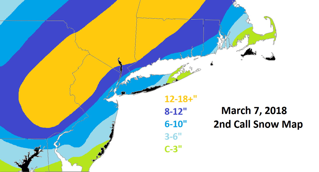
I personally was not too happy to be so far removed from 12 to 18 hoping that comes back into my area.Frank_Wx wrote:Notice my updated snow map says *2nd* and not final...

jmanley32- Senior Enthusiast
- Posts : 20593
Reputation : 108
Join date : 2013-12-12
Age : 43
Location : Yonkers, NY
Re: March 7th Godzilla: 1st Call Snow Map
![]() by nutleyblizzard Tue Mar 06, 2018 3:46 pm
by nutleyblizzard Tue Mar 06, 2018 3:46 pm
Man people need to chill out!!! Its nowcasting time folks. Yes you want to look at the short range models, but also current map observations and radars.amugs wrote:Great post by Geo (33)
People. when you have the RGEM, HRDPS, Euro, EPS and Ukie in one corner. And you have the GFS and NAM in the other. 98% of the time, you're going to toss the GFS and NAM.

nutleyblizzard- Senior Enthusiast
- Posts : 1957
Reputation : 41
Join date : 2014-01-30
Age : 58
Location : Nutley, new jersey

SoulSingMG- Senior Enthusiast
- Posts : 2853
Reputation : 74
Join date : 2013-12-11
Location : Long Island City, NY
Re: March 7th Godzilla: 1st Call Snow Map
![]() by WeatherBob Tue Mar 06, 2018 3:48 pm
by WeatherBob Tue Mar 06, 2018 3:48 pm

WeatherBob- Meteorologist
- Posts : 683
Reputation : 83
Join date : 2013-12-13
Location : Caldwell, NJ - NW Essex County - Altitude 500 FT
Re: March 7th Godzilla: 1st Call Snow Map
![]() by emokid51783 Tue Mar 06, 2018 3:49 pm
by emokid51783 Tue Mar 06, 2018 3:49 pm
amugs wrote:Great post by Geo (33)
People. when you have the RGEM, HRDPS, Euro, EPS and Ukie in one corner. And you have the GFS and NAM in the other. 98% of the time, you're going to toss the GFS and NAM.
Whose post is that?
emokid51783- Posts : 144
Reputation : 5
Join date : 2013-12-12
Age : 41
Location : Jersey City Heights, NJ
Page 15 of 24 • 1 ... 9 ... 14, 15, 16 ... 19 ... 24 ![]()