
 Search
12/16-12/17 Godzilla: Final Snow Map & Obsevations
Page 14 of 32 •  1 ... 8 ... 13, 14, 15 ... 23 ... 32
 ![]()
Re: 12/16-12/17 Godzilla: Final Snow Map & Obsevations
![]() by snowlover78 Wed Dec 16, 2020 4:17 pm
by snowlover78 Wed Dec 16, 2020 4:17 pm
snowlover78- Posts : 99
Join date : 2016-01-20
Re: 12/16-12/17 Godzilla: Final Snow Map & Obsevations
![]() by Frank_Wx Wed Dec 16, 2020 4:19 pm
by Frank_Wx Wed Dec 16, 2020 4:19 pm
snowlover78 wrote:OMG its all white out conditions here. Heavy snow right now with wind
WOW
Frank_Wx- Godzilla Seeker

- Posts : 21305
Join date : 2013-01-05 -

Re: 12/16-12/17 Godzilla: Final Snow Map & Obsevations
![]() by billg315 Wed Dec 16, 2020 4:19 pm
by billg315 Wed Dec 16, 2020 4:19 pm
jmanley32 wrote:no and I was kidding though the program you used did look like water colors. A light bride is a board with holes you put a paper on it and you put the see through pegs on it and then turn the light on and the picture lights up.billg315 wrote:jmanley32 wrote:Got flurries. Temp on phone says 31. I'm willing to bet it's lower. I'll have check local station on wx underground later. Doing lightbrite with my daughter. Anyone remember those?
No. Is that what you accused me of using for my snow-map earlier??lol
Yeah, I know you were joking. I had to do it in a hurry before work so I didn't have time to make it look good. Hopefully its close to accurate though.

billg315- Advanced Forecaster - Mod

- Posts : 4515
Reputation : 185
Join date : 2015-01-24
Age : 50
Location : Flemington, NJ
Re: 12/16-12/17 Godzilla: Final Snow Map & Obsevations
![]() by dsix85 Wed Dec 16, 2020 4:20 pm
by dsix85 Wed Dec 16, 2020 4:20 pm
dsix85- Pro Enthusiast

- Posts : 349
Reputation : 8
Join date : 2014-01-01
Location : New York
Re: 12/16-12/17 Godzilla: Final Snow Map & Obsevations
![]() by jmanley32 Wed Dec 16, 2020 4:20 pm
by jmanley32 Wed Dec 16, 2020 4:20 pm
Last edited by jmanley32 on Wed Dec 16, 2020 4:23 pm; edited 1 time in total

jmanley32- Senior Enthusiast

- Posts : 20595
Reputation : 108
Join date : 2013-12-12
Age : 43
Location : Yonkers, NY
brownie likes this post
Re: 12/16-12/17 Godzilla: Final Snow Map & Obsevations
![]() by Frank_Wx Wed Dec 16, 2020 4:20 pm
by Frank_Wx Wed Dec 16, 2020 4:20 pm
So I first want to be clear, that these observations can change, but as I stand at 4 PM, the atmospheric environment with this storm IS colder.
— NY NJ PA Weather (@nynjpaweather) December 16, 2020
_________________
_______________________________________________________________________________________________________
CLICK HERE to view NJ Strong Snowstorm Classifications

Frank_Wx- Godzilla Seeker
- Posts : 21305
Reputation : 328
Join date : 2013-01-05
Age : 32
Location : Jersey City, NJ -
Re: 12/16-12/17 Godzilla: Final Snow Map & Obsevations
![]() by SENJsnowman Wed Dec 16, 2020 4:21 pm
by SENJsnowman Wed Dec 16, 2020 4:21 pm
Last edited by SENJsnowman on Wed Dec 16, 2020 4:23 pm; edited 1 time in total
SENJsnowman- Senior Enthusiast
- Posts : 1189
Reputation : 61
Join date : 2017-01-06
Age : 51
Location : Bayville, NJ
Re: 12/16-12/17 Godzilla: Final Snow Map & Obsevations
![]() by billg315 Wed Dec 16, 2020 4:21 pm
by billg315 Wed Dec 16, 2020 4:21 pm
Frank_Wx wrote:I think CAD is over powering the warmth to this point. The real threat to lower snow amounts may not be mid-level warmth or mixing, it is this dry slot. Racing N-NE.

Would not be the first time I/we were done in by a dry slot. A lot of heavy snow lined up before that gets here, so let's enjoy those heavy bands first and see how it progresses.
billg315- Advanced Forecaster - Mod
- Posts : 4515
Reputation : 185
Join date : 2015-01-24
Age : 50
Location : Flemington, NJ
Re: 12/16-12/17 Godzilla: Final Snow Map & Obsevations
![]() by amugs Wed Dec 16, 2020 4:22 pm
by amugs Wed Dec 16, 2020 4:22 pm
frank 638 wrote:please bring this hereamugs wrote:SNJ reports outside Philly getting 2-3/4" rates and wind driven blizzard like conditions.
I"M FRIGGIN WORKIN ON IT PEEPS ONLY SO MUCH ONE MAN CAN DO HERE YA KNOW - DOC RALLY THE BAND!!!!!!! (CP, SNOWIE, YOU AND ME) WHERE GETTIN BACK TO TOGETHER!!
Last edited by amugs on Wed Dec 16, 2020 4:26 pm; edited 1 time in total
_________________
Mugs
AKA:King: Snow Weenie
Self Proclaimed
WINTER 2014-15 : 55.12" +.02 for 6 coatings (avg. 35")
WINTER 2015-16 Total - 29.8" (Avg 35")
WINTER 2016-17 : 39.5" so far

amugs- Advanced Forecaster - Mod
- Posts : 15095
Reputation : 213
Join date : 2013-01-07
Age : 54
Location : Hillsdale,NJ
bloc1357, Taffy and sabamfa like this post
Re: 12/16-12/17 Godzilla: Final Snow Map & Obsevations
![]() by jmanley32 Wed Dec 16, 2020 4:25 pm
by jmanley32 Wed Dec 16, 2020 4:25 pm
Thats a insanely heavy band to south jersey and i presume its moving north, have look at radar.billg315 wrote:Frank_Wx wrote:I think CAD is over powering the warmth to this point. The real threat to lower snow amounts may not be mid-level warmth or mixing, it is this dry slot. Racing N-NE.
Would not be the first time I/we were done in by a dry slot. A lot of heavy snow lined up before that gets here, so let's enjoy those heavy bands first and see how it progresses.
jmanley32- Senior Enthusiast
- Posts : 20595
Reputation : 108
Join date : 2013-12-12
Age : 43
Location : Yonkers, NY
Re: 12/16-12/17 Godzilla: Final Snow Map & Obsevations
![]() by heehaw453 Wed Dec 16, 2020 4:27 pm
by heehaw453 Wed Dec 16, 2020 4:27 pm

heehaw453- Advanced Forecaster

- Posts : 3906
Reputation : 86
Join date : 2014-01-20
Location : Bedminster Township, PA Elevation 600' ASL
Re: 12/16-12/17 Godzilla: Final Snow Map & Obsevations
![]() by SENJsnowman Wed Dec 16, 2020 4:30 pm
by SENJsnowman Wed Dec 16, 2020 4:30 pm

SENJsnowman- Senior Enthusiast
- Posts : 1189
Reputation : 61
Join date : 2017-01-06
Age : 51
Location : Bayville, NJ
Re: 12/16-12/17 Godzilla: Final Snow Map & Obsevations
![]() by heehaw453 Wed Dec 16, 2020 4:30 pm
by heehaw453 Wed Dec 16, 2020 4:30 pm

heehaw453- Advanced Forecaster
- Posts : 3906
Reputation : 86
Join date : 2014-01-20
Location : Bedminster Township, PA Elevation 600' ASL
Re: 12/16-12/17 Godzilla: Final Snow Map & Obsevations
![]() by snowlover78 Wed Dec 16, 2020 4:31 pm
by snowlover78 Wed Dec 16, 2020 4:31 pm
snowlover78- Posts : 99
Reputation : 5
Join date : 2016-01-20
Location : Plumstead, Ocean County, NJ
Re: 12/16-12/17 Godzilla: Final Snow Map & Obsevations
![]() by jmanley32 Wed Dec 16, 2020 4:31 pm
by jmanley32 Wed Dec 16, 2020 4:31 pm
jmanley32- Senior Enthusiast
- Posts : 20595
Reputation : 108
Join date : 2013-12-12
Age : 43
Location : Yonkers, NY
Re: 12/16-12/17 Godzilla: Final Snow Map & Obsevations
![]() by amugs Wed Dec 16, 2020 4:31 pm
by amugs Wed Dec 16, 2020 4:31 pm

Look at that heavy heavy yellow 30-35dbz band of just puking snow
_________________
Mugs
AKA:King: Snow Weenie
Self Proclaimed
WINTER 2014-15 : 55.12" +.02 for 6 coatings (avg. 35")
WINTER 2015-16 Total - 29.8" (Avg 35")
WINTER 2016-17 : 39.5" so far
amugs- Advanced Forecaster - Mod
- Posts : 15095
Reputation : 213
Join date : 2013-01-07
Age : 54
Location : Hillsdale,NJ
Re: 12/16-12/17 Godzilla: Final Snow Map & Obsevations
![]() by jmanley32 Wed Dec 16, 2020 4:33 pm
by jmanley32 Wed Dec 16, 2020 4:33 pm
that would be fantastic for majority on the board, if somehow we can fill in that snow hole we will be crushed, we still wil lget impressive amounts even with the snow hole as look how much is in front of it.snowlover78 wrote:This must be a heaviest band which we experiencing here at the moment. Easily it will be 2-3 inch per hour zone. Whiteout. Its all coming up north. I don’t see at all any warm air creeping in. We may stay all snow here. Keeping the fingers crossed.
jmanley32- Senior Enthusiast
- Posts : 20595
Reputation : 108
Join date : 2013-12-12
Age : 43
Location : Yonkers, NY

pkmak- Posts : 27
Reputation : 0
Join date : 2013-08-30
Location : Glen Cove NY
RJB8525 likes this post
Re: 12/16-12/17 Godzilla: Final Snow Map & Obsevations
![]() by dkodgis Wed Dec 16, 2020 4:35 pm
by dkodgis Wed Dec 16, 2020 4:35 pm

dkodgis- Senior Enthusiast
- Posts : 2622
Reputation : 98
Join date : 2013-12-29
Re: 12/16-12/17 Godzilla: Final Snow Map & Obsevations
![]() by heehaw453 Wed Dec 16, 2020 4:36 pm
by heehaw453 Wed Dec 16, 2020 4:36 pm
SN+ Frequent 35 mph gusts now. Visibility < 1/2 mile
heehaw453- Advanced Forecaster
- Posts : 3906
Reputation : 86
Join date : 2014-01-20
Location : Bedminster Township, PA Elevation 600' ASL
Re: 12/16-12/17 Godzilla: Final Snow Map & Obsevations
![]() by DAYBLAZER Wed Dec 16, 2020 4:39 pm
by DAYBLAZER Wed Dec 16, 2020 4:39 pm
amugs wrote:
Look at that heavy heavy yellow 30-35dbz band of just puking snow


DAYBLAZER- Posts : 228
Reputation : 20
Join date : 2017-03-12
Location : Hopatcong, NJ Sussex County
Re: 12/16-12/17 Godzilla: Final Snow Map & Obsevations
![]() by Frank_Wx Wed Dec 16, 2020 4:39 pm
by Frank_Wx Wed Dec 16, 2020 4:39 pm
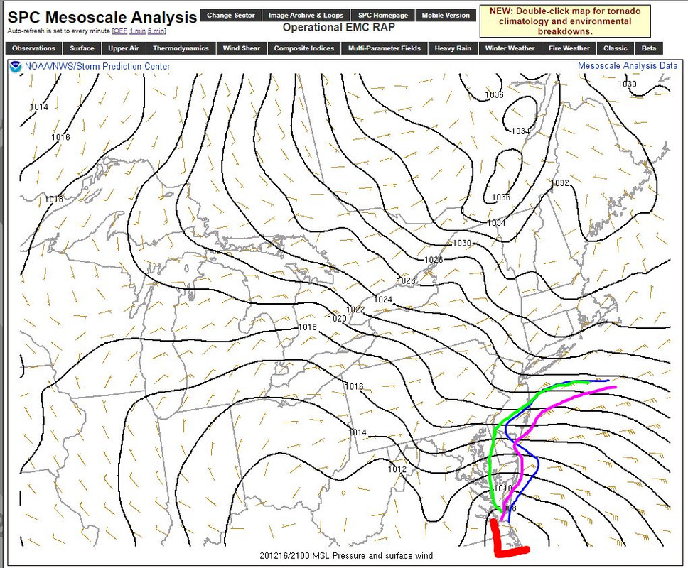
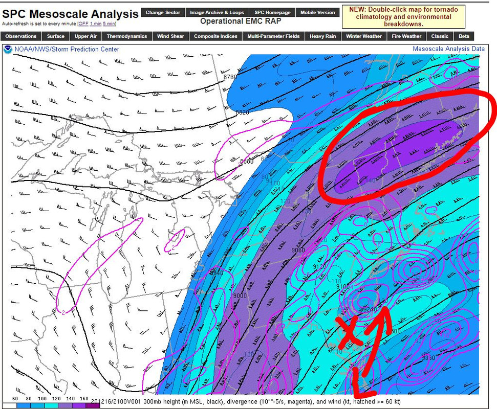
Meanwhile, an impressive upper level jet streak has developed over New England. Between this feature and the HP, I feel pretty good about the low taking a more eastern track. I think the GFS is way off, but time will tell.
Last edited by Frank_Wx on Wed Dec 16, 2020 4:42 pm; edited 1 time in total
_________________
_______________________________________________________________________________________________________
CLICK HERE to view NJ Strong Snowstorm Classifications
Frank_Wx- Godzilla Seeker
- Posts : 21305
Reputation : 328
Join date : 2013-01-05
Age : 32
Location : Jersey City, NJ -
Re: 12/16-12/17 Godzilla: Final Snow Map & Obsevations
![]() by billg315 Wed Dec 16, 2020 4:40 pm
by billg315 Wed Dec 16, 2020 4:40 pm
billg315- Advanced Forecaster - Mod
- Posts : 4515
Reputation : 185
Join date : 2015-01-24
Age : 50
Location : Flemington, NJ
Re: 12/16-12/17 Godzilla: Final Snow Map & Obsevations
![]() by dkodgis Wed Dec 16, 2020 4:41 pm
by dkodgis Wed Dec 16, 2020 4:41 pm
dkodgis- Senior Enthusiast
- Posts : 2622
Reputation : 98
Join date : 2013-12-29
Re: 12/16-12/17 Godzilla: Final Snow Map & Obsevations
![]() by amugs Wed Dec 16, 2020 4:42 pm
by amugs Wed Dec 16, 2020 4:42 pm

Last edited by amugs on Wed Dec 16, 2020 4:44 pm; edited 1 time in total
_________________
Mugs
AKA:King: Snow Weenie
Self Proclaimed
WINTER 2014-15 : 55.12" +.02 for 6 coatings (avg. 35")
WINTER 2015-16 Total - 29.8" (Avg 35")
WINTER 2016-17 : 39.5" so far
amugs- Advanced Forecaster - Mod
- Posts : 15095
Reputation : 213
Join date : 2013-01-07
Age : 54
Location : Hillsdale,NJ
Re: 12/16-12/17 Godzilla: Final Snow Map & Obsevations
![]() by Frank_Wx Wed Dec 16, 2020 4:42 pm
by Frank_Wx Wed Dec 16, 2020 4:42 pm

_________________
_______________________________________________________________________________________________________
CLICK HERE to view NJ Strong Snowstorm Classifications
Frank_Wx- Godzilla Seeker
- Posts : 21305
Reputation : 328
Join date : 2013-01-05
Age : 32
Location : Jersey City, NJ -
Re: 12/16-12/17 Godzilla: Final Snow Map & Obsevations
![]() by jmanley32 Wed Dec 16, 2020 4:47 pm
by jmanley32 Wed Dec 16, 2020 4:47 pm
I just looked at 3km nam and it barely gives most of the area 6 inches, am i missing something? Ok why is 12km so different? I thought these were the same model just different resolutions?Frank_Wx wrote:We're at a critical moment. The low has to soon decide does it stay N-NW or N-NE. I overlaid the most recent GFS, NAM and HRRR tracks on the current observations. For some locations, this is the difference between 3 inches or 10, 6 inches or 12, 12 inches or 18, etc. The 18z NAM was an absolute whopper with blitzing snow, and it happens to be in between the GFS/HRRR.
Meanwhile, an impressive upper level jet streak has developed over New England. Between this feature and the HP, I feel pretty good about the low taking a more eastern track. I think the GFS is way off, but time will tell.
jmanley32- Senior Enthusiast
- Posts : 20595
Reputation : 108
Join date : 2013-12-12
Age : 43
Location : Yonkers, NY
Page 14 of 32 • 1 ... 8 ... 13, 14, 15 ... 23 ... 32 ![]()