Thursday's Mothrazilla, Part II: First Forecast
+44
bloc1357
Dunnzoo
hurrysundown23
larryrock72
phil155
dsvinos
docstox12
weatherwatchermom
SNOW MAN
kalleg
Snow88
Radz
Joe Snow
oldtimer
gigs68
mmanisca
Vinnydula
SkiSeadooJoe
algae888
jaydoy
dkodgis
Zhukov1945
skinsfan1177
2004blackwrx
lglickman1
Artingerb
Grselig
GreyBeard
moleson
nutleyblizzard
essexcountypete
billg315
sroc4
amugs
Fededle22
CPcantmeasuresnow
Irish
heehaw453
SENJsnowman
aiannone
DAYBLAZER
jmanley32
frank 638
Frank_Wx
48 posters
Page 1 of 18
Page 1 of 18 • 1, 2, 3 ... 9 ... 18 
 Thursday's Mothrazilla, Part II: First Forecast
The fury February onslaught continues as our area stares down yet another winter storm Thursday into Friday. Personally, this one snuck up on me because I did not believe it had a chance to be an area-wide significant snowstorm. The mid-level trough axis is west of here and the Atlantic ridge is overlapping onto the coast. However, Mother Nature said 'va fangul' and snow begets snow, so here we are.
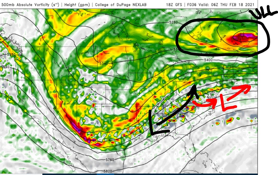
One key reason why the surface low will take a path that favors colder temps staying locked into our area is because of the ULL - upper level low - spinning over SE Canada. The confluence that is draped across northern New England is preventing 500mb heights from growing above our metro. As the primary low attempts to cut into Ohio, it quickly realizes it has nowhere to move and transfers its energy to a secondary low near the Mid-Atlantic. There are several 'waves' of upper energy that are expected to pass south which may mean more than one surface low developing. Because our area is wedged between an incoming trough, SE ridge, and extremely powerful upper level jet stream to the north, the gradient and dynamics associated with this storm are going to be one of the more impressive we've seen yet this winter.
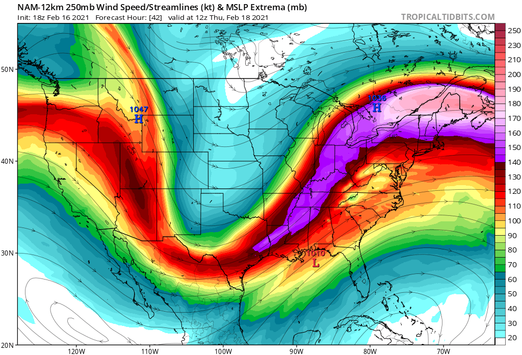
The 200mb jet streak (how many times have we seen this picture on the year?) is approaching 200 KTs. In conjunction with very potent 500mb vorticity passing through, that calls for an impressive precipitation field to develop. This is one reason why I'm not buying the EURO very much. It shows a sharp cut-off of the precip for areas N&W of NYC.
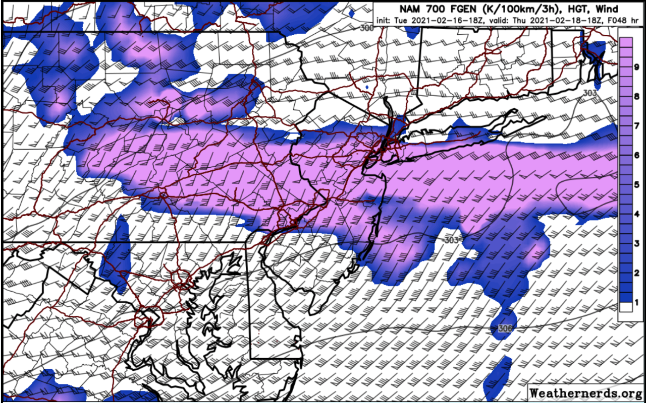
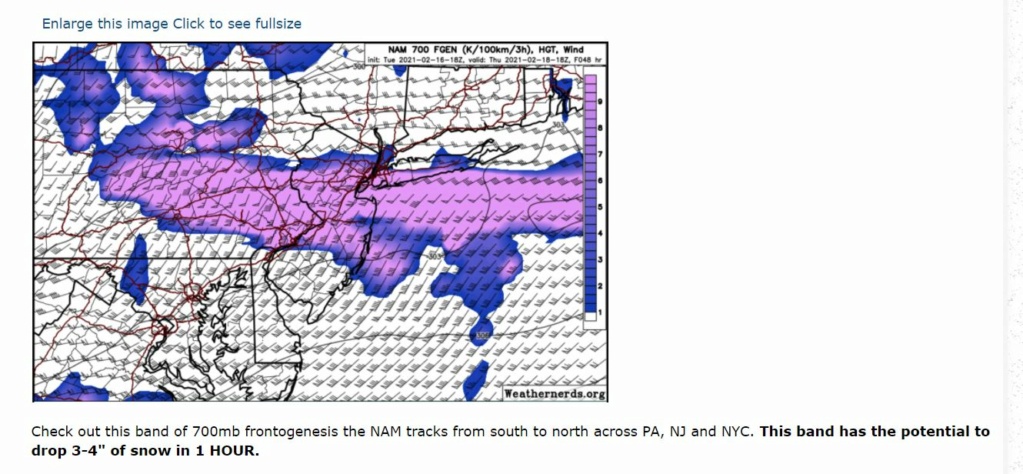
Check out this band of 700mb frontogenesis the NAM tracks from south to north across PA, NJ and NYC. This band has the potential to drop 3-4" of snow in 1 HOUR.
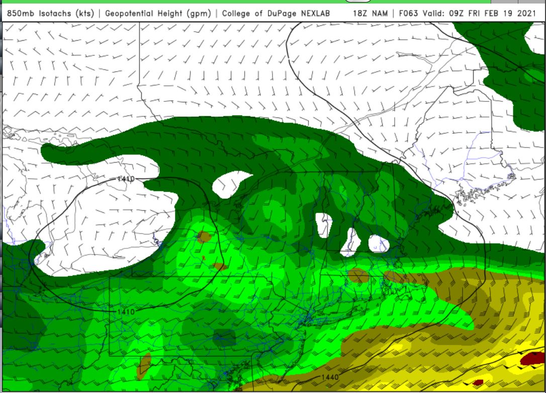
One possible negative is the track of the 850mb low. If it gets as far west as shown here - in NW PA - then there is a very good chance the 850mb temps along the coast rise above freezing levels. This would limit the amount of snow that falls over certain parts of our area.
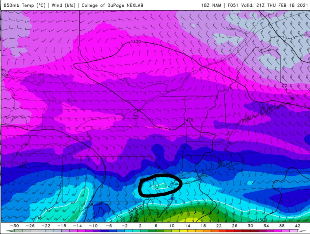
Remember that sneaky warm wedge in the boundary layers during the February 1st Roidzilla that caused parts of EPA and WNJ to see sleet? You can see the NAM hints at something like that coming to fruition again. Now by this time most of the damage has already been done and we're already in a dry slow. However, be mindful that this is not the most perfect set-up and that warm wedges are possible again.

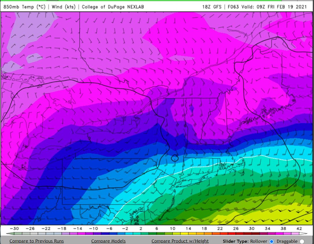
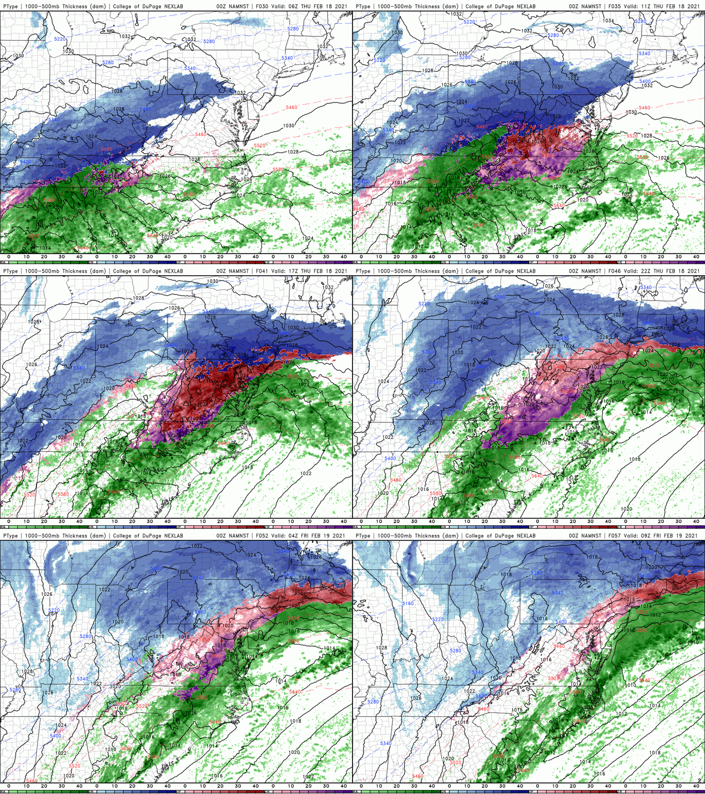
What's interesting is seeing the northern stream energy trying to phase in at the last moment. This would lengthen the duration of this storm by a few hours as additional banding tries to develop on the west side as the low pulls away. But as you can see, the immediate coast at this point is too warm for snow. However, areas N&W would end up seeing 'bonus' snow IF this comes to fruition. The overall idea here is that the storm could continue well into Friday (say 3-5pm) IF this phasing and back-building of precipitation forms.
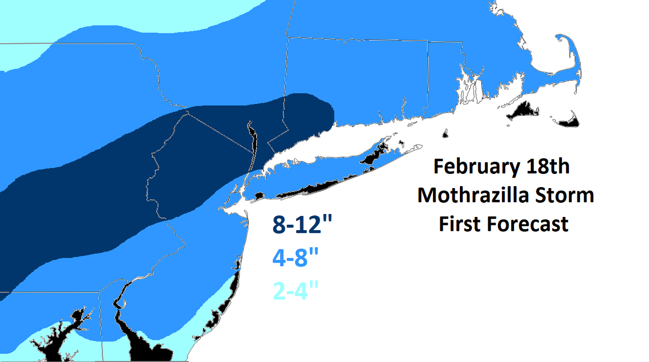
My first forecast takes all of these factors into account. One thing I'll have to keep an eye on is the immediate coast. I'm thinking >8" is possible since the 700mb frontogenesis band tracks directly over that area. This includes NYC Metro. However, the negatives are daytime snowfall and the fact this storm is going to move very fast. I will adjust on my second forecast map if necessary.

One key reason why the surface low will take a path that favors colder temps staying locked into our area is because of the ULL - upper level low - spinning over SE Canada. The confluence that is draped across northern New England is preventing 500mb heights from growing above our metro. As the primary low attempts to cut into Ohio, it quickly realizes it has nowhere to move and transfers its energy to a secondary low near the Mid-Atlantic. There are several 'waves' of upper energy that are expected to pass south which may mean more than one surface low developing. Because our area is wedged between an incoming trough, SE ridge, and extremely powerful upper level jet stream to the north, the gradient and dynamics associated with this storm are going to be one of the more impressive we've seen yet this winter.

The 200mb jet streak (how many times have we seen this picture on the year?) is approaching 200 KTs. In conjunction with very potent 500mb vorticity passing through, that calls for an impressive precipitation field to develop. This is one reason why I'm not buying the EURO very much. It shows a sharp cut-off of the precip for areas N&W of NYC.

Check out this band of 700mb frontogenesis the NAM tracks from south to north across PA, NJ and NYC. This band has the potential to drop 3-4" of snow in 1 HOUR.

One possible negative is the track of the 850mb low. If it gets as far west as shown here - in NW PA - then there is a very good chance the 850mb temps along the coast rise above freezing levels. This would limit the amount of snow that falls over certain parts of our area.

Remember that sneaky warm wedge in the boundary layers during the February 1st Roidzilla that caused parts of EPA and WNJ to see sleet? You can see the NAM hints at something like that coming to fruition again. Now by this time most of the damage has already been done and we're already in a dry slow. However, be mindful that this is not the most perfect set-up and that warm wedges are possible again.


What's interesting is seeing the northern stream energy trying to phase in at the last moment. This would lengthen the duration of this storm by a few hours as additional banding tries to develop on the west side as the low pulls away. But as you can see, the immediate coast at this point is too warm for snow. However, areas N&W would end up seeing 'bonus' snow IF this comes to fruition. The overall idea here is that the storm could continue well into Friday (say 3-5pm) IF this phasing and back-building of precipitation forms.

My first forecast takes all of these factors into account. One thing I'll have to keep an eye on is the immediate coast. I'm thinking >8" is possible since the 700mb frontogenesis band tracks directly over that area. This includes NYC Metro. However, the negatives are daytime snowfall and the fact this storm is going to move very fast. I will adjust on my second forecast map if necessary.
_________________
_______________________________________________________________________________________________________
CLICK HERE to view NJ Strong Snowstorm Classifications
CPcantmeasuresnow, billg315 and DAYBLAZER like this post
 Re: Thursday's Mothrazilla, Part II: First Forecast
Loving it frank thank you for ur post bring on the 
frank 638- Senior Enthusiast

- Posts : 2878
Reputation : 37
Join date : 2016-01-01
Age : 41
Location : bronx ny
 Re: Thursday's Mothrazilla, Part II: First Forecast
Very nice, cannot complain about that map one bit. Just hope those pesky 850s stay away for all. So if that back end does build in the people not far NW are they go see rain wash all the snow away on Friday?

jmanley32- Senior Enthusiast

- Posts : 20645
Reputation : 108
Join date : 2013-12-12
Age : 43
Location : Yonkers, NY
 Re: Thursday's Mothrazilla, Part II: First Forecast
Today was the first day that I was able to actually see my whole walkway and driveway since the 2/1 storm. The last of the buildup melted in the 49 degree heatwave we had up here today.
Not that I'm complaining, mind you. Bring it on. Great explanation and write-up Frank, much appreciated as always.
Not that I'm complaining, mind you. Bring it on. Great explanation and write-up Frank, much appreciated as always.

DAYBLAZER- Posts : 228
Reputation : 20
Join date : 2017-03-12
Location : Hopatcong, NJ Sussex County
 Re: Thursday's Mothrazilla, Part II: First Forecast
00z NAM has an even more robust jet streak than 18z...madonne


_________________
_______________________________________________________________________________________________________
CLICK HERE to view NJ Strong Snowstorm Classifications
 Re: Thursday's Mothrazilla, Part II: First Forecast


_________________
_______________________________________________________________________________________________________
CLICK HERE to view NJ Strong Snowstorm Classifications
 Re: Thursday's Mothrazilla, Part II: First Forecast
By Thursday 7pm the NAM is showing the coast changing over


_________________
_______________________________________________________________________________________________________
CLICK HERE to view NJ Strong Snowstorm Classifications
 Re: Thursday's Mothrazilla, Part II: First Forecast
Total precip...that northern cut off. Gotta watch it


_________________
_______________________________________________________________________________________________________
CLICK HERE to view NJ Strong Snowstorm Classifications

aiannone- Senior Enthusiast - Mod

- Posts : 4827
Reputation : 92
Join date : 2013-01-07
Location : Saint James, LI (Northwest Suffolk Co.)
 Re: Thursday's Mothrazilla, Part II: First Forecast
how much of that yellow around NYC is rain or IP do you think to cut into the snowfall? And yeah pivotal isnt showing same thing.Frank_Wx wrote:Total precip...that northern cut off. Gotta watch it

jmanley32- Senior Enthusiast

- Posts : 20645
Reputation : 108
Join date : 2013-12-12
Age : 43
Location : Yonkers, NY
 Re: Thursday's Mothrazilla, Part II: First Forecast
3km nam has a big area of changeover after the main snow comes through. Man that is a fast storm, how does it put down 8-12 in literally like 6 hrs, its go snow that hard?
edit well on 3km totals are less.
edit well on 3km totals are less.
Last edited by jmanley32 on Tue Feb 16, 2021 9:34 pm; edited 1 time in total

jmanley32- Senior Enthusiast

- Posts : 20645
Reputation : 108
Join date : 2013-12-12
Age : 43
Location : Yonkers, NY
SENJsnowman- Senior Enthusiast

- Posts : 1198
Reputation : 61
Join date : 2017-01-06
Age : 51
Location : Long Branch, NJ
 Re: Thursday's Mothrazilla, Part II: First Forecast
Position of the low is the same. My guess is different resolutions is causing differences in how precip is shown. But that’s kinda strange.
jmanley32 wrote:how much of that yellow around NYC is rain or IP do you think to cut into the snowfall? And yeah pivotal isnt showing same thing.Frank_Wx wrote:Total precip...that northern cut off. Gotta watch it
Probably .20 or so.
jmanley32 wrote:3km nam has a big area of changeover after the main snow comes through. Man that is a fast storm, how does it put down 8-12 in literally like 6 hrs, its go snow that hard?
I guess you didn’t read my post!!
_________________
_______________________________________________________________________________________________________
CLICK HERE to view NJ Strong Snowstorm Classifications
 Re: Thursday's Mothrazilla, Part II: First Forecast
_________________
_______________________________________________________________________________________________________
CLICK HERE to view NJ Strong Snowstorm Classifications
SENJsnowman likes this post
 Re: Thursday's Mothrazilla, Part II: First Forecast
NAM also shows what I said about extending the duration of the storm. Bad news for the coast is that precip that falls after 8pm Thursday may not be snow. But it helps areas N&W

_________________
_______________________________________________________________________________________________________
CLICK HERE to view NJ Strong Snowstorm Classifications
 Re: Thursday's Mothrazilla, Part II: First Forecast
Great write up. I think your map makes good sense based on the frontogenesis and risk for mixing. Areas that band well and have minimal mixing will approach 1' and that will most likely be NW-I95.
heehaw453- Advanced Forecaster

- Posts : 3931
Reputation : 86
Join date : 2014-01-20
Location : Bedminster Township, PA Elevation 600' ASL
Frank_Wx likes this post
 Re: Thursday's Mothrazilla, Part II: First Forecast
Frank your map is almost identical to regular 00z NAM snow map.

jmanley32- Senior Enthusiast

- Posts : 20645
Reputation : 108
Join date : 2013-12-12
Age : 43
Location : Yonkers, NY
 Re: Thursday's Mothrazilla, Part II: First Forecast
Frank_Wx wrote:By Thursday 7pm the NAM is showing the coast changing over
That's more than just the coast. No?

Irish- Pro Enthusiast

- Posts : 788
Reputation : 19
Join date : 2019-01-16
Age : 46
Location : Old Bridge, NJ
 Re: Thursday's Mothrazilla, Part II: First Forecast
Oh I did read your post, just so hard believe, that would be harder than we saw in last two storms, too bad its not for hours on end hahaFrank_Wx wrote:
Position of the low is the same. My guess is different resolutions is causing differences in how precip is shown. But that’s kinda strange.jmanley32 wrote:how much of that yellow around NYC is rain or IP do you think to cut into the snowfall? And yeah pivotal isnt showing same thing.Frank_Wx wrote:Total precip...that northern cut off. Gotta watch it
Probably .20 or so.jmanley32 wrote:3km nam has a big area of changeover after the main snow comes through. Man that is a fast storm, how does it put down 8-12 in literally like 6 hrs, its go snow that hard?
I guess you didn’t read my post!!

jmanley32- Senior Enthusiast

- Posts : 20645
Reputation : 108
Join date : 2013-12-12
Age : 43
Location : Yonkers, NY
 Re: Thursday's Mothrazilla, Part II: First Forecast
Irish wrote:Frank_Wx wrote:By Thursday 7pm the NAM is showing the coast changing over
That's more than just the coast. No?
Anyone east of 95 is coast in my book
_________________
_______________________________________________________________________________________________________
CLICK HERE to view NJ Strong Snowstorm Classifications
 Re: Thursday's Mothrazilla, Part II: First Forecast
Frank_Wx wrote:Irish wrote:Frank_Wx wrote:By Thursday 7pm the NAM is showing the coast changing over
That's more than just the coast. No?
Anyone east of 95 is coast in my book
Gotcha, close enough.

Irish- Pro Enthusiast

- Posts : 788
Reputation : 19
Join date : 2019-01-16
Age : 46
Location : Old Bridge, NJ
 Re: Thursday's Mothrazilla, Part II: First Forecast
Frank_Wx wrote:Total precip...that northern cut off. Gotta watch it
Frank:
Isn't that precip as of 10PM Thursday night? If so wouldn't areas especially to the north of NYC expect more precip and snow after this?

CPcantmeasuresnow- Wx Statistician Guru

- Posts : 7281
Reputation : 230
Join date : 2013-01-07
Age : 103
Location : Eastern Orange County, NY
 Re: Thursday's Mothrazilla, Part II: First Forecast
CPcantmeasuresnow wrote:Frank_Wx wrote:Total precip...that northern cut off. Gotta watch it
Frank:
Isn't that precip as of 10PM Thursday night? If so wouldn't areas especially to the north of NYC expect more precip and snow after this?
Yes...here’s the real total. Not a whole lot expanded north but it did some.

_________________
_______________________________________________________________________________________________________
CLICK HERE to view NJ Strong Snowstorm Classifications
CPcantmeasuresnow likes this post
 Re: Thursday's Mothrazilla, Part II: First Forecast
Icon definitely expanding the precip north.
18z

00z

Run hasn’t finished
18z
00z
Run hasn’t finished
_________________
_______________________________________________________________________________________________________
CLICK HERE to view NJ Strong Snowstorm Classifications
 Re: Thursday's Mothrazilla, Part II: First Forecast
Great potential for this storm and looking forward to what it does. Great write up Frank as usual. What are looking at with timing? Start-Finish? It's looking like it may continue into Friday as well.

Fededle22- Posts : 169
Reputation : 2
Join date : 2013-03-08
Location : West Orange, NJ
Page 1 of 18 • 1, 2, 3 ... 9 ... 18 
Page 1 of 18
Permissions in this forum:
You cannot reply to topics in this forum
 Home
Home

